Topics > Tyne and Wear > North Tyneside > Historic Buildings and Monuments in North Tyneside
Historic Buildings and Monuments in North Tyneside
This page includes historic buildings, monuments, parks and sites in North Tyneside, compiled from two sources: a) Listed buildings and scheduled monuments, from the National Heritage List for England[1]. b) the List of Buildings, Parks and Gardens of Special Local Architectural or Historic Interest ('Local List') from North Tyneside Council.[2] Use the Search in the data table (below) if looking for a specific building / monument, or to filter on a particular area e.g. type: Wallsend. Jump to photos / links.
| Structure | List No. | Grade | Built~ | Ward | Locality | Note |
|---|---|---|---|---|---|---|
| Hadrian's Wall in wall mile 0, Wallsend Roman fort, Segedunum | 1005914 | n/a | Roman | Wallsend | Wallsend | Scheduled Monument |
| Hadrian's Wall in wall mile 0, two sections of Hadrian's Wall between Sharpe Road and The Avenue | 1005915 | n/a | Roman | Wallsend | Wallsend | Scheduled Monument |
| Enclosure 600yds (540m) NE of Burradon House | 1005912 | n/a | Camperdown | Burradon | Scheduled Monument | |
| Clifford's Fort | 1005896 | n/a | Tynemouth | North Shields | Scheduled Monument. See 4 separate listed buildings on this site. | |
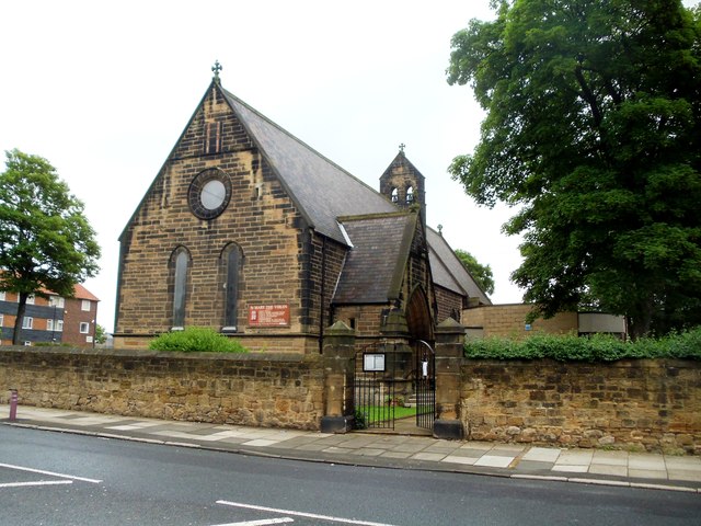
| Church of St Edward | 1413394 | II | 1928 | Whitley Bay | Whitley Bay | |
| Church of St Paul | 1185615 | II | 1864 | Whitley Bay | Whitley Bay | By Anthony Salvin |
| Cullercoats Radio Station Browns Point | 1389373 | II | 1906 | Whitley Bay | Cullercoats | |
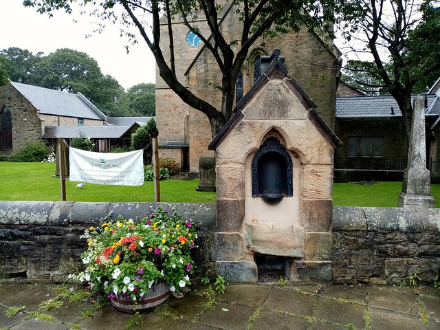
| Drinking Fountain East of Church of St Paul | 1355006 | II | 1864 | Whitley Bay | Whitley Bay | |
| K4 Telephone Kiosk | 1025340 | II | c.1930 | Whitley Bay | Whitley Bay | Station Road |
| Sewer Gas Lamp | 1025338 | II | c.1900 | Whitley Bay | Whitley Bay | Near Watts Slope |
| Sewer Gas Lamp | 1405388 | II | c.1900 | Whitley Bay | Whitley Bay | Park Road / Marine Avenue |
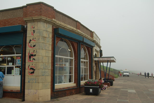
| Spanish City | 1025339 | II | 1910 | Whitley Bay | Whitley Bay | |
| Whitley Bay Station Main Building with Train Shed | 1355007 | II | 1882 | Whitley Bay | Whitley Bay | Now Whitley Bay Metro Station |
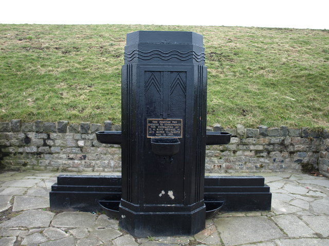
| Drinking Fountain | 1410877 | II | 1937 | Monkseaton North | Whitley Bay | North Pomonade |
| Sewer Gas Lamp | 1405386 | II | Monkseaton North | Monkseaton | Deanholm | |
| Sewer Gas Lamp | 1405387 | II | Monkseaton North | Monkseaton | Brantwood / Pykerley | |
| Sewer Gas Lamp | 1405390 | II | Monkseaton North | Whitley Bay | Near Watts Slope | |
| Sewer Gas Lamp at East Corner of Junction with Pykerley Road | 1025337 | II | Monkseaton North | Monkseaton | ||
| Sewer Gas Lamp at North Corner of Junction with Grange Park | 1185720 | II | Monkseaton North | Monkseaton | ||
| War Memorial and Dwarf Walls, Steps and Piers Surrounding | 1299616 | II | 1922 | Monkseaton North | Whitley Bay | On the Links |
| Sewer Gas Lamp | 1405383 | II | Monkseaton South | Monkseaton | ||
| Sewer Gas Lamp | 1405385 | II | Monkseaton South | Monkseaton | ||
| Sewer Gas Lamp | 1405389 | II | Monkseaton South | Monkseaton | ||
| Barn, Gin-Gang and Shelter Shed to West of Brierdene Farmhouse | 1185581 | II | C18th | St Mary's | Whitley Bay | |
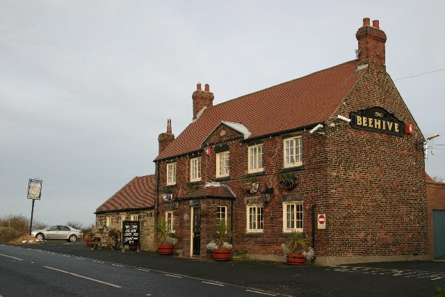
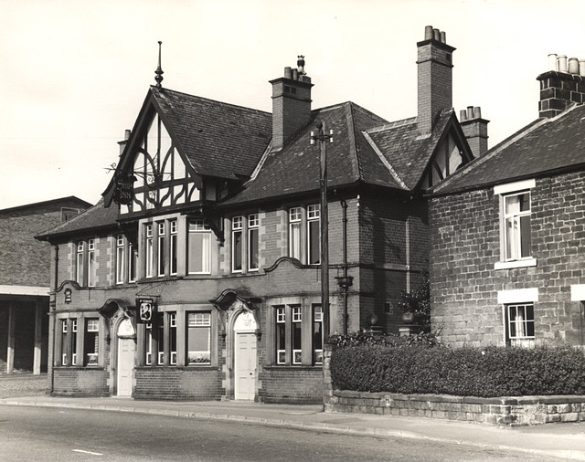
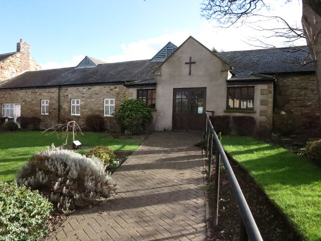
| Beehive Public House | 1355005 | II | C18th | St Mary's | Near Earsdon | |
| Bleak Hope House | 1025399 | II | C19th | St Mary's | Earsdon | |
| Chapel and Crematorium at Whitley Bay Cemetery | 1096121 | II* | 1913 | St Mary's | Whitley Bay | |
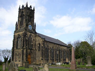
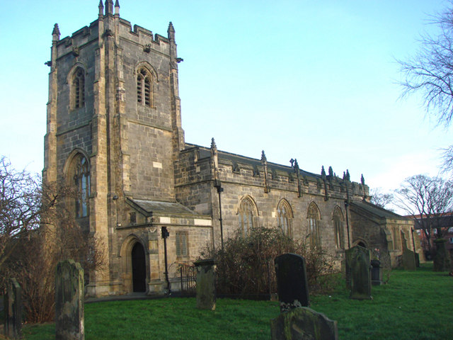
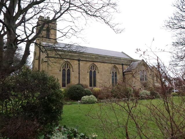
| Church of St Alban | 1184308 | II | 1837 | St Mary's | Earsdon | By John & Benjamin Green |
| Edward Eccles Church Hall and Walls and Piers in Front | 1025397 | II | 1911 | St Mary's | Earsdon | |
| Entrance Gates, Shelters, Railings and Boundary Walls to Whitley Bay Cemetery | 1096119 | II | 1913 | St Mary's | Whitley Bay | |
| Former Fisherman's Cottage | 1408464 | II | C19th | St Mary's | St Mary's Island | |
| Hartley Disaster Memorial North East of Church of St Alban, and Surrounding Wall | 1354997 | II | 1862 | St Mary's | Earsdon | |
| Manor House | 1184323 | II | C18th | St Mary's | Earsdon | |
| Oven South of the Garth and Wall Attached | 1025400 | II | C17th | St Mary's | Earsdon | |
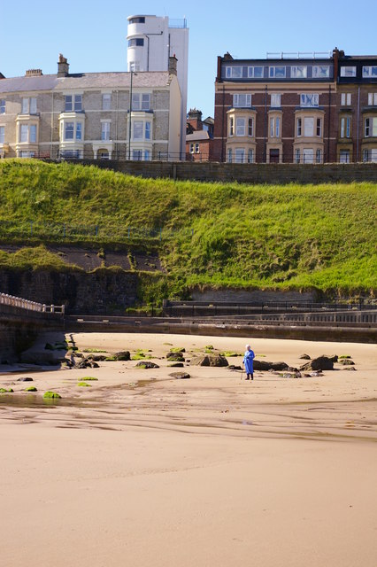
| St Mary's Island Lighthouse, Keepers' Cottages and Compound Walls | 1408299 | II | 1898 | St Mary's | St Mary's Island | |
| Stable and Carriage Shed South of Bleak Hope House, and Walls and Piers Adjoining | 1354998 | II | C19th | St Mary's | Earsdon | |
| Superintendents House at Whitley Bay Cemetery | 1096120 | II | 1913 | St Mary's | Whitley Bay | |
| The Garth | 1300188 | II | C17th | St Mary's | Earsdon | |
| Vicarage of St Alban | 1025396 | II | 1836 | St Mary's | Earsdon | By John & Benjamin Green |
| Walls and Piers in Front of Bleak Hope House | 1300186 | II | C19th | St Mary's | Earsdon | |
| Walls and Piers in Front of Manor House | 1025398 | II | C19th | St Mary's | Earsdon | |
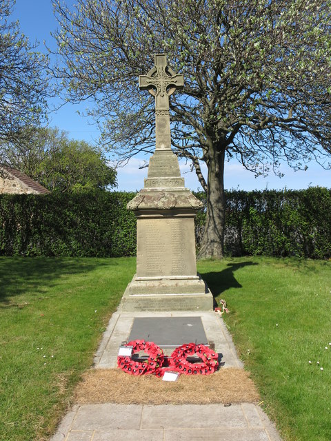
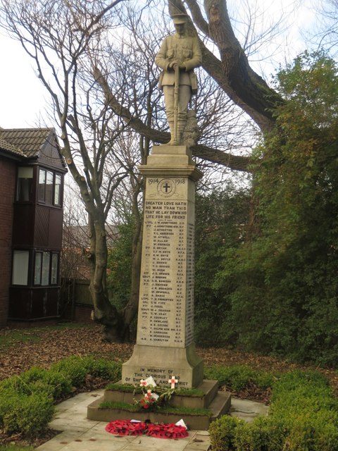
| War Memorial and Railings Surrounding | 1184342 | II | 1924 | St Mary's | Earsdon | |
| Adamson Memorial Drinking Fountain Opposite Number 68 | 1025403 | II | 1888 | Cullercoats | Cullercoats | |
| Cliff House | 1299734 | II* | 1768 | Cullercoats | Cullercoats | |
| Cullercoats Lifeboat Station | 1411983 | II | 1852 | Cullercoats | Cullercoats | |
| Cullercoats Watch Club House | 1025361 | II | 1879 | Cullercoats | Cullercoats | |
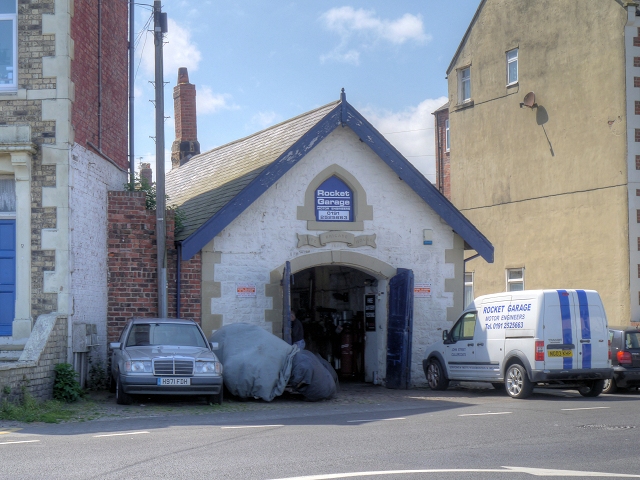
| Rocket Garage | 1025344 | II | 1867 | Cullercoats | Cullercoats | |
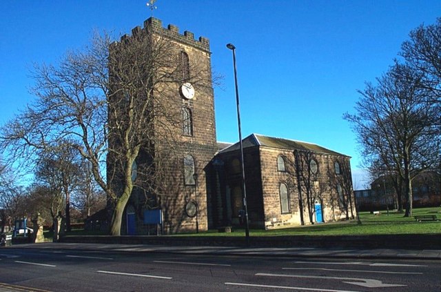
| Benton House (Conservative Club) | 1354993 | II | C18th | Benton | Benton | |
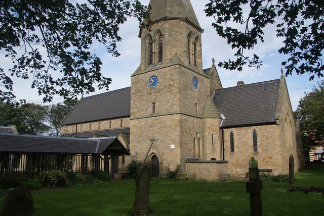
| Church of St Bartholomew | 1025393 | II | 1790 | Benton | Benton | |
| Ethel Williams Hall | 1025390 | II | 1734 | Benton | Benton | Front Street. Former vicarage/orphanage |
| Ethel Williams Hall (North House) | 1354992 | II | C18th | Benton | Benton | Font Street, North House |
| Ha-Ha South of Benton House | 1184194 | II | C18th | Benton | Benton | |
| Manor House | 1025389 | II | C17th | Benton | Benton | |
| Milepost at junction of Front Street and Manorfields | 1392672 | II | C19th | Benton | Benton | |
| Vogue Hair Stylists' Shop | 1025391 | II | C20th | Benton | Benton | |
| British Gas Research Station Including Attached Restaurant Block to South | 1259313 | II* | 1967 | Camperdown | Killingworth | |
| Burradon Tower (East of Burrandon House) | 1025387 | II | cC16th | Camperdown | Burradon | Scheduled Monument(1018644) |
| War Memorial outside St Cuthbert's Church | 1411540 | II | 1920 | Chirton | Chirton, North Shields | |
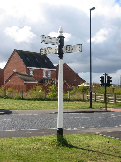
| Gate Piers to South of Murton Farmhouse | 1185120 | II | ? | Collingwood | Murton / New York | |
| Murton Farmhouse | 1025353 | II | C18th | Collingwood | Murton / New York | |
| New York War Memorial | 1185120 | II | 1921 | Collingwood | New York | |
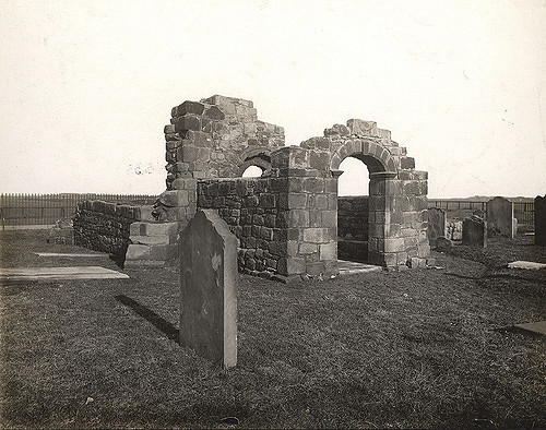
| Church of Holy Cross | 1299638 | I | C12th | Howdon | Wallsend | Ruins of medieval church. Scheduled Monument(1018643) |
| Church of St Mary | 1355038 | II | 1876 | Howdon | Willington, Wallsend | Willington |
| Elmgrove | 1025328 | II | 1876 | Howdon | Willington, Wallsend | Former vicarage |
| House West of Bewicke School | 1355004 | II | 1878 | Howdon | Wallsend | |
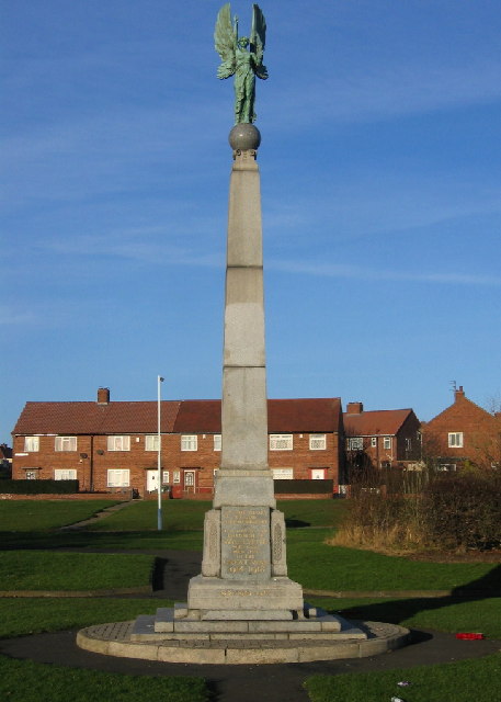
| War Memorial | 1025324 | II | 1918 | Howdon | Wallsend | |
| Church Hall | 1025394 | II | 1869 | Killingworth | Killingworth | |
| Church of St John the Evangelist | 1184227 | II | 1869 | Killingworth | Killingworth | |
| Dial Cottage | 1025392 | II* | C18th | Killingworth | West Moor / Killingworth | Home of George Stephenson |
| East Farmhouse | 1025395 | II | C18th | Killingworth | Killingworth | |
| East House Farmhouse | 1025386 | II | C18th | Killingworth | Killingworth | |
| Gate Piers, Gates, Overthrow, Walls and Railings East of Church of St John the Evangelist | 1354994 | II | 1869 | Killingworth | Killingworth | |
| Killingworth Cottage | 1184242 | II | C18th | Killingworth | Killingworth | West Lane |
| North Farmhouse | 1184235 | II | 1725 | Killingworth | Killingworth | West Lane |
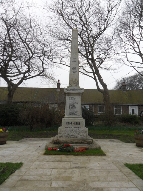
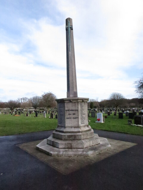
| 1914-18 War memorial in St Bartholomew's Churchyard, Longbenton | 1410079 | II | 1922 | Longbenton | Longbenton | |
| East Benton Farmhouse | 1355042 | II | C18th | Northumberland | Benton | |
| Farm Buildings to East of East Benton Farmhouse | 1185523 | II | C18th | Northumberland | Benton | |
| Nos. 6 and 7, Spring Terrace | 1025354 | II | 1830 | Preston | Preston, North Shields | |
| Christ Church | 1185050 | II | C17th | Preston | Preston, North Shields | |
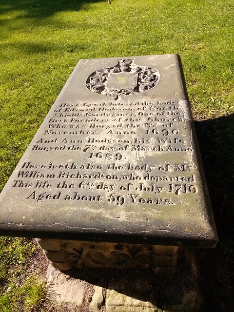
| Hodgson Tomb Circa 4 Metres South of Tower of Christ Church | 1185085 | II | 1690 | Preston | Preston, North Shields | |
| Memorial to Ralph Gardiner | 1025367 | II | 1882 | Preston | Preston, North Shields | |
| Nos. 1 and 2, Lovaine Terrace | 1253592 | II | 1852 | Preston | Preston, North Shields | |
| Numbers 1, 2, 3 and 4 and Terrace in Front | 1025364 | II | 1800 | Preston | Preston, North Shields | |
| Numbers 5 and 6 and Terrace in Front | 1025366 | II | 1830 | Preston | Preston, North Shields | |
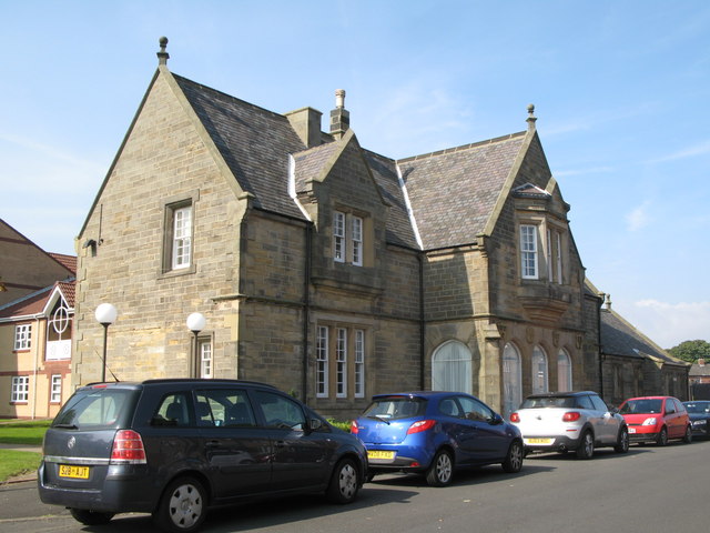
| Outpatients Building of Victoria Jubilee Infirmary | 1025341 | II | 1932 | Preston | Preston, North Shields | Hawkeys Lane |
| Piers and Walls to East of Number 1 | 1025365 | II | 1800 | Preston | Preston, North Shields | |
| Piers and Walls to West and South of Christ Church | 1355012 | II | C18th | Preston | Preston, North Shields | |
| Preston Colliery War Memorial | 1410878 | II | 1924 | Preston | Preston, North Shields | |
| Rosella Place | 1354999 | II | 1820 | Preston | Preston, North Shields | |
| The Moorings | 1025363 | II | 1850 | Preston | North Shields | Brightman Road |
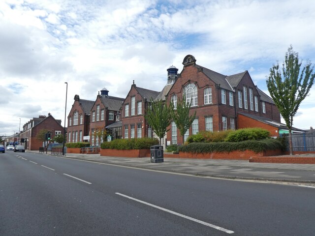
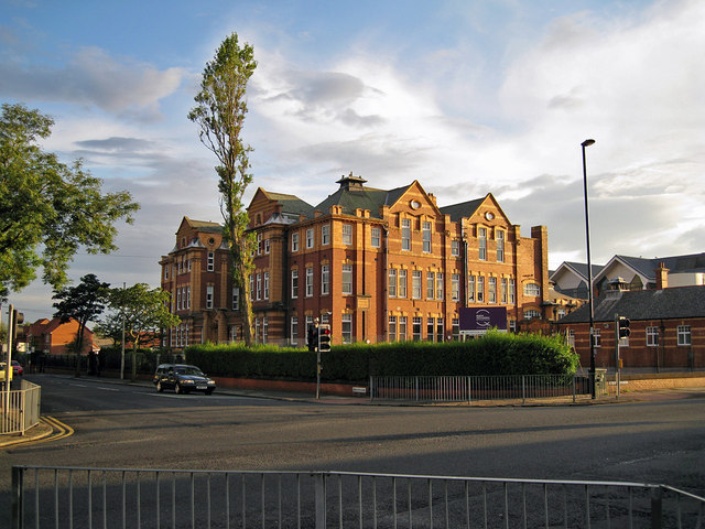
| Tyne Metropolitan College, Academy Campus | 1392979 | II | 1902 | Preston | Preston, North Shields | Hawkey's Lane. Closed. |
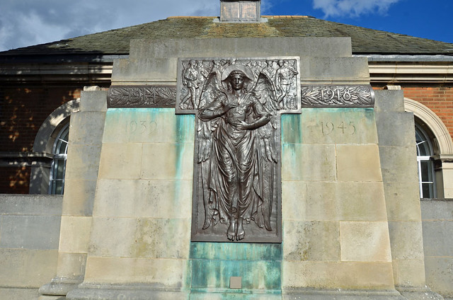
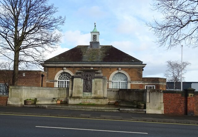
| War Memorial, Benches, Walls, Piers, Terrace and Steps | 1184732 | II | 1923 | Preston | Preston, North Shields | Hawkey's Lane |
| West Backworth medieval settlement, 300m south east of West Farm | 1016974 | n/a | Valley? | Backworth | Scheduled Monument (earthworks & below ground remains) | |
| Backworth Miners Welfare Hall | 1354995 | II | 1778 | Valley | Backworth | |
| Backworth War Memorial | 1406711 | II | Valley | Backworth | ||
| Dairy Cottage | 1300194 | II | C19th | Valley | Backworth | |
| Dukes Cottages and Wall in Front | 1354996 | II | 1840 | Valley | Backworth | |
| Finger Post | 1408200 | II | C19th | Valley | Shiremoor | |
| The Old Cottage and Stables and Loft Adjoining, Occupied by G Thomas | 1184292 | II | C18th | Valley | Backworth | |
| War Memorial | 1184272 | II | 1924 | Valley | Shiremoor | |
| War Memorial | 1184409 | II | Valley | West Allotment | ||
| No. 1, Howard Street | 1025377 | II | 1807 | Riverside | North Shields | |
| Nos. 1-5, Northumberland Place | 1025348 | II | C19th | Riverside | North Shields | |
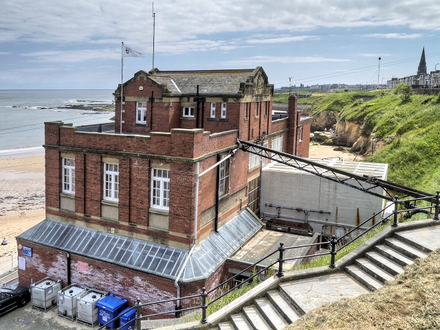
| Accumulator Tower in Albert Edward Dock | 1354990 | II* | 1882 | Riverside | North Shields | |
| No. 10, New Quay | 1025347 | II | 1800 | Riverside | North Shields | |
| Nos. 65, 66 and 67, Borough Road, 11, New Quay | 1355018 | II | 1856 | Riverside | North Shields | By Benjamin Green |
| No. 12, Union Road | 1025360 | II | C19th | Riverside | North Shields | |
| Nos. 2 and 3 Spring Terrace | 1299783 | II | 1830 | Riverside | North Shields | |
| No. 53, Tynemouth Road | 1025336 | II | 1878 | Riverside | North Shields | |
| No. 68, Borough Road | 1025362 | II | 1856 | Riverside | North Shields | |
| Accommodation Arch East of Junction with Martin Road | 1185516 | II | 1839 | Riverside | North Shields | |
| Bewicke Schools | 1299634 | II | 1878 | Riverside | North Shields | |
| Church of St John the Evangelist | 1355013 | II | 1862 | Riverside | Percy Main, North Shields |
By Anthony Salvin |
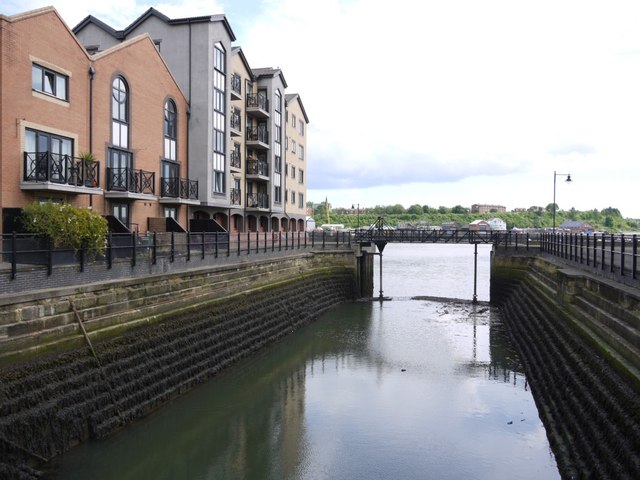
| Locks and Lock Gates in Albert Edward Dock | 1184814 | II | 1882 | Riverside | North Shields | |
| Low Dock | 1355008 | II | C19th | Riverside | North Shields | Liddell Street |
| Smith's Dock Company War Memorial in West Park | 1025346 | II | 1922 | Riverside | North Shields | Minton Lane |
| The Porthole Public House | 1390831 | II | 1897 | Riverside | North Shields | |
| Tyne Pedestrian and Cyclist Tunnels | 1380276 | II | 1951 | Riverside | Howdon | |
| Willington Viaduct | 1025323 | II | 1839 | Riverside | Wallsend | |
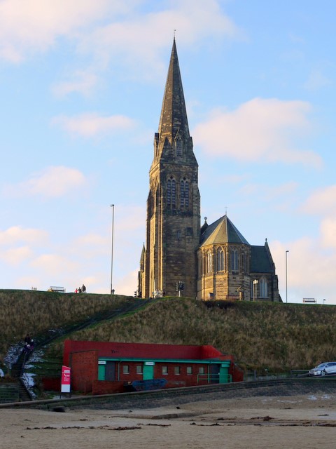
| Church of St George | 1355000 | I | 1884 | Tynemouth | Cullercoats | |
| Tynemouth Station Main and Subsidiary Buildings with Canopies and Footbridge | 1185168 | II* | 1882 | Tynemouth | Tynemouth | Now Metro Station |
| Dudley War Memorial | 1406693 | II | 1923 | Weetslade | Dudley | |
| Milepost, Wideopen | 1450225 | II | C19th | Weetslade | Wideopen | On the Great North Road |
| Milestone About 150 Metres South of Church of Sacred Heart | 1355320 | II | C18th | Weetslade | Wideopen | |
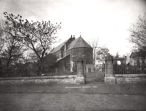
| Sacred Heart Church | 1391786 | II | 1865 | Weetslade | Wideopen | |
| Seaton Burn House | 1025388 | II | C18th | Weetslade | Seaton Burn | |
| Seaton Burn War Memorial | 1412829 | II | 1922 | Weetslade | Seaton Burn | |
| No. 12, Park Terrace | 1025333 | II | 1876 | Wallsend | Wallsend | |
| Buddle Arts Centre | 1299625 | II | 1876 | Wallsend | Wallsend | |
| Buddle School House | 1185487 | II | 1876 | Wallsend | Wallsend | |
| Castellated Wall at Lily Bank Cottage | 1389441 | II | C18th | Wallsend, Lily Bank | Wallsend | |
| Church of St Luke | 1025335 | II | 1887 | Wallsend | Wallsend | Tower added 1906 |
| Church of St Peter | 1025326 | II* | 1809 | Wallsend | Wallsend | |
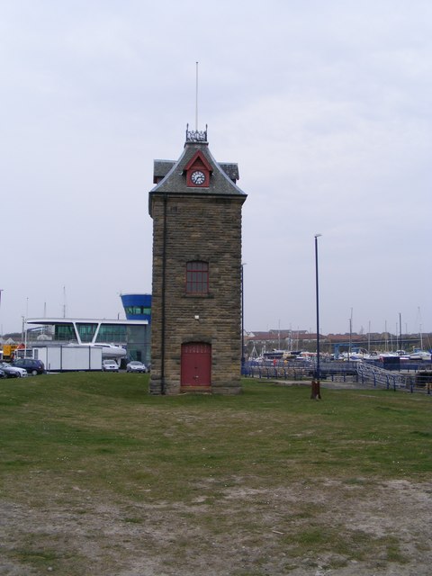
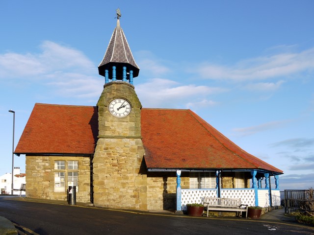
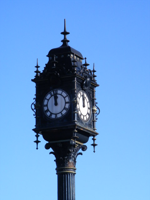
| Clock at South West Corner of Junction with Station Road | 1025325 | II | C19th | Wallsend | Wallsend | Built by Swan Hunter |
| Coach and Horses Public House | 1025331 | II | 1907 | Wallsend | Wallsend | |
| Cross House | 1366082 | II | 1748 | Wallsend | Wallsend, The Green | |
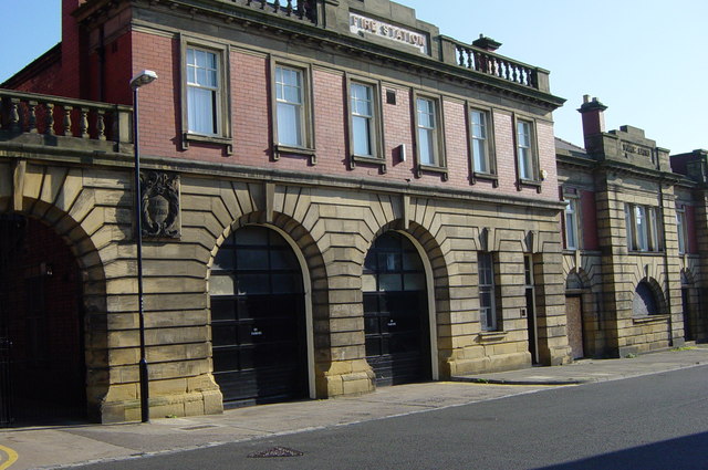
| Fire Station | 1366095 | II | 1908 | Wallsend | Wallsend | |
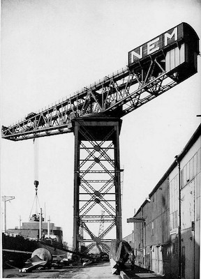
| Giant Crane at Former NEM Works | 1253566 | II* | 1909 | Wallsend | Wallsend | No longer there! Delisted. |
| Jasmine House | 1355039 | II | C18th | Wallsend | Wallsend, The Green | |
| Lily Bank Cottage | 1185480 | II | C19th | Wallsend | Wallsend | |
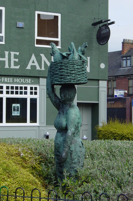
| Market Woman, High Street, junction with Station Road, Wallsend | 1437357 | II | 1966 | Wallsend | Wallsend | by Hans Schwarz |
| Milestone About One Metre South of Cemetery Wall | 1025327 | II | C18th | Wallsend | ||
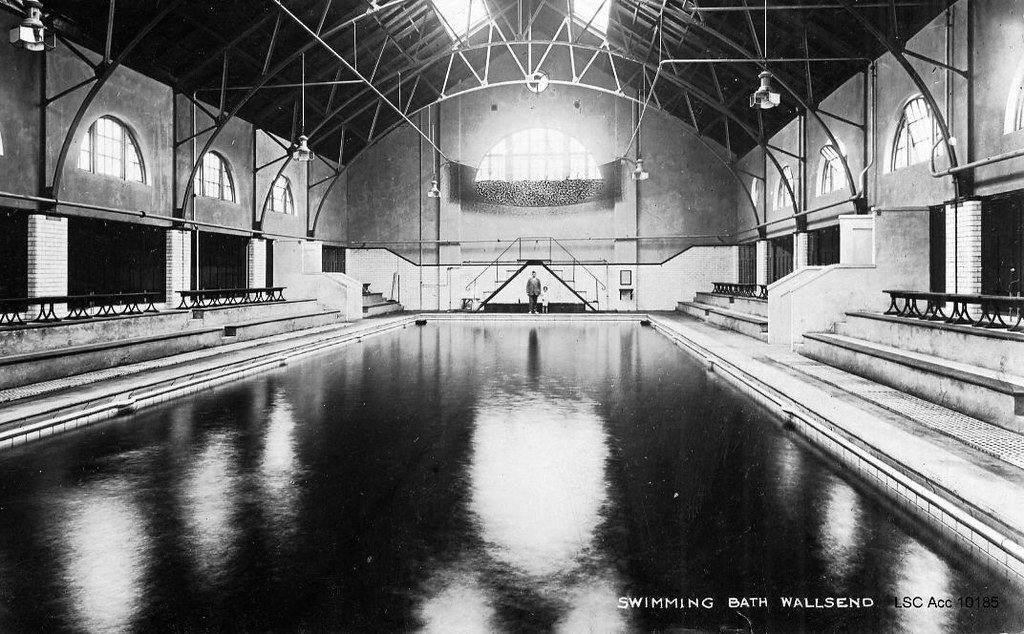
| Public Baths | 1025332 | II | 1908 | Wallsend | Wallsend | Behind the Town Hall |
| Remains of East Gate of Segedunum Re-Sited in Wallsend Park (Hall Grounds) | 1355040 | II | Wallsend | |||
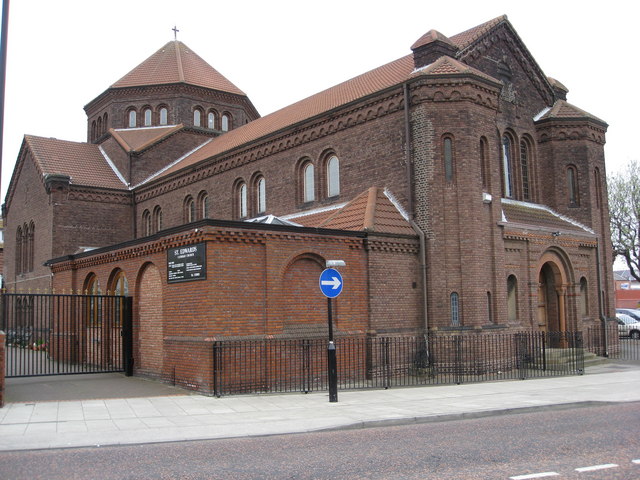
| Roman Catholic Church of Our Lady and St Columba and attached gates | 1431024 | II | Wallsend | |||
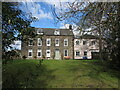
| Wallsend Hall (previously Sir G B Hunter Memorial Hospital) | 1185390 | II | C19th | Wallsend | Wallsend | By The Green |
| Social Services Area Office | 1366090 | II | Wallsend | |||
| Stocks to West of Church of St Peter | 1355037 | II | Wallsend | |||
| Thermal Syndicate Offices | 1355041 | II | Wallsend | |||
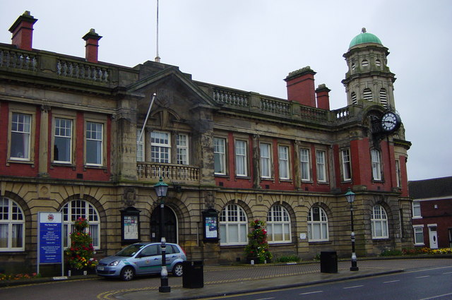
| Town Hall | 1025330 | II | 1908 | Wallsend | Wallsend | |
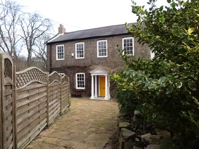
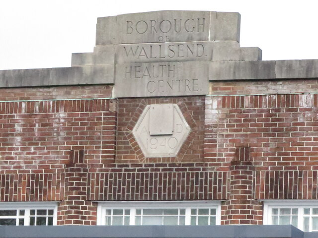
| Wallsend Health Centre | 1413007 | II | 1940 | Wallsend | Wallsend, The Green | |
| Wallsend Library | 1418250 | II | 1966 | Wallsend | Wallsend | Former library, Ferndale Avenue |
| Wallsend Memorial Hall incorporating a First World War memorial with Second World War additions | 1413255 | II | Wallsend | |||
| Nos. 1 and 2, Allendale Place | 1025401 | II | 1840 | Tynemouth | Tynemouth | |
| Clifford's Fort South and East Wall Facing River | 1185263 | II* | 1672 | Tynemouth | North Shields | |
| Clifford's Fort West and South West Wall | 1025359 | II* | 1672 | Tynemouth | North Shields | |
| Collingwood Monument and Guns | 1355011 | II* | 1845 | Tynemouth | Tynemouth | |
| Nos. 1 and 3, Tynemouth Road | 1185212 | II | 1790 | Tynemouth | Tynemouth | |
| No. 1, Dawson Square | 1355020 | II | 1830 | Tynemouth | Tynemouth | |
| No. 1, Newcastle Terrace | 1355009 | II | 1830 | Tynemouth | Tynemouth | |
| Nos. 1-11 (Inc 6a, 7a and 11a), Bath Terrace | 1025402 | II | 1830 | Tynemouth | Tynemouth | |
| Nos. 1-3, Tynemouth Terrace | 1025358 | II | 1830 | Tynemouth | Tynemouth | |
| Nos. 1-5, Colbeck Terrace | 1025368 | II | 1860 | Tynemouth | Tynemouth | |
| No. 105, Howard Street | 1025380 | II | 1882 | Tynemouth | North Shields | |
| No. 106, Howard Street | 1299946 | II | 1820 | Tynemouth | North Shields | |
| Nos. 2 and 3, Huntington Place | 1025381 | II | 1840 | Tynemouth | Tynemouth | |
| Nos. 2-4, Dawson Square | 1184545 | II | 1860 | Tynemouth | Tynemouth | |
| No. 25, Howard Street | 1299960 | II | 1841 | Tynemouth | North Shields | |
| No. 3 Clark Tombs and Enclosing Wall About 10 Metres South of East End of Presbytery at Tynemouth Priory | 1184651 | II | C18th | Tynemouth | Tynemouth | |
| No. 3, Allendale Place | 1184382 | II | 1840 | Tynemouth | Tynemouth | |
| Nos. 4-8, Huntington Place | 1025342 | II | 1840 | Tynemouth | Tynemouth | |
| Nos. 47, Front Street | 1184558 | II | 1780 | Tynemouth | Tynemouth | |
| No. 47a, Percy Gardens | 1299885 | II | 1916 | Tynemouth | Tynemouth | Look-out post & gun emplacement. |
| Nos. 5 and 6, Dawson Square | 1025370 | II | 1860 | Tynemouth | Tynemouth | |
| No. 52, Front Street | 1025372 | II | 1770 | Tynemouth | Tynemouth | |
| Nos. 53 and 53a, Front Street | 1300061 | II | C18th | Tynemouth | Tynemouth | |
| No. 54, Front Street | 1355022 | II | C18th | Tynemouth | Tynemouth | |
| No. 55, Front Street | 1300071 | II | C19th | Tynemouth | Tynemouth | |
| No. 56, Front Street | 1025373 | II | C18th | Tynemouth | Tynemouth | |
| Nos. 57, 58 and 59, Front Street | 1184588 | II | C18th | Tynemouth | Tynemouth | |
| No. 9, Huntington Place | 1025343 | II | 1760 | Tynemouth | Tynemouth | |
| No. 9, Tyne Street | 1355015 | II | 1830 | Tynemouth | Tynemouth | |
| No. 97, Howard Street | 1025379 | II | 1780 | Tynemouth | North Shields | |
| Nos. 98, 99 and 100, Howard Street | 1184795 | II | 1795 | Tynemouth | North Shields | |
| Anderson Tomb About 23 Metres South of Tynemouth Priory Church | 1184717 | II | 1714 | Tynemouth | Tynemouth | |
| Ballard's Smoke House clifford's Fort and Boundary Stones Attached | 1299778 | II | C19th | Tynemouth | Noth Shields, Clifford's Fort | |
| Baptist Church | 1025378 | II | 1846 | Tynemouth | North Shields | Howard Street. By John Dobson. |
| Beacon House Trinity Buildings Number 1 | 1025356 | II | 1727 | Tynemouth | North Shields | Old High Light |
| Borough Treasurer's Department | 1299964 | II | Tynemouth | |||
| II | Tynemouth | North Shields | See: 1299975 | |||
| Brigade Cottage | 1025351 | II | 1887 | Tynemouth | Tynemouth | |
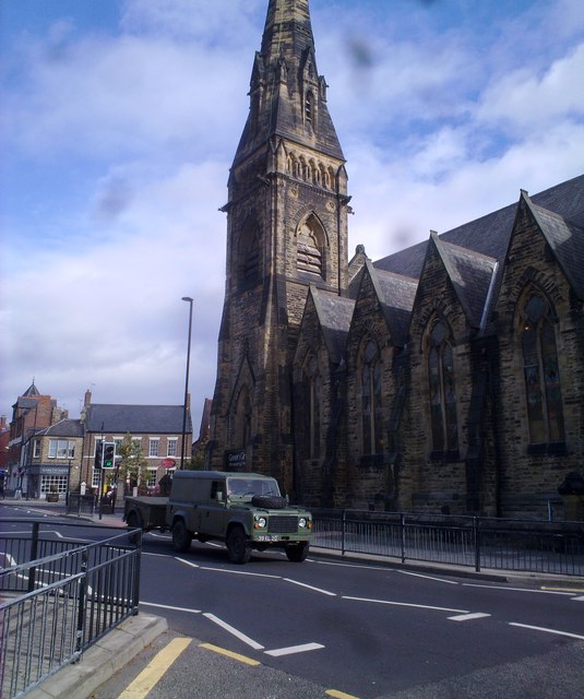
| Church of Holy Saviour | 1025369 | II | 1841 | Tynemouth | Tynemouth | By John and Benjamin Green |
| Church of St Augustin | 1401442 | II | 1884 | Tynemouth | North Shields | By Robert Anderson |
| Church of St Columba | 1355010 | II | 1858 | Tynemouth | North Shields | By John Dobson |
| Clifford's Fort Trinity House Almshouses and Boundary Stone Attached | 1355016 | II | 1727 | Tynemouth | North Shields | The Old Low Light |
| Clock Tower | 1184619 | II | 1861 | Tynemouth | Tynemouth | |
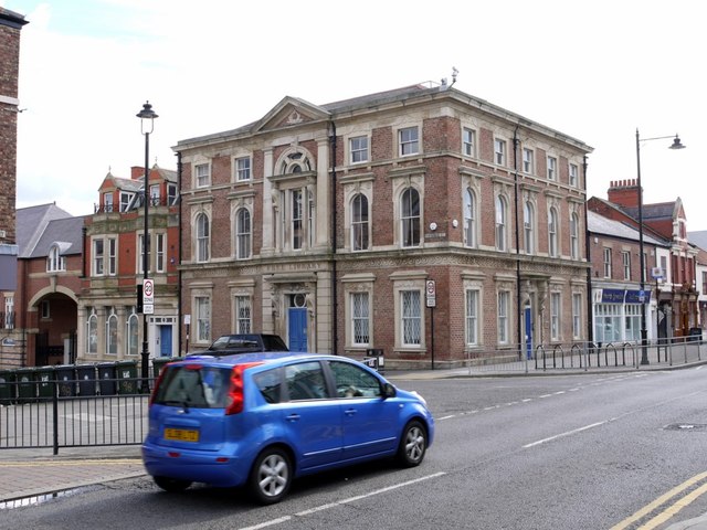
| Former North Shields Municipal Complex | 1299975 | II | C19th | Tynemouth | North Shields | |
| Field House | 1025355 | II | Tynemouth | |||
| First World War Memorial Opposite Number 6 | 1354985 | II | 1920 | Tynemouth | Tynemouth | |
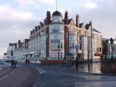
| Grand Hotel | 1025376 | II | 1872 | Tynemouth | ||
| Haswell Tomb About 12 Metres South of Percy Chapel of Tynemouth Priory Church | 1025375 | II | Tynemouth | |||
| Holly House and Walls and Piers in Front | 1025371 | II | Tynemouth | |||
| Irvins Building | 1061408 | II | 1913 | Tynemouth | North Shields | Union Road, Fish Quay |
| Land of Green Ginger Shopping Mall and Former Church Hall Adjoining on East | 1354984 | II | 1868 | Tynemouth | Tynemouth | Front Street. Former Congregational church. |
| Liddell Tomb About 20 Metres South of Percy Chapel of Tynemouth Priory Church | 1184676 | II | Tynemouth | |||
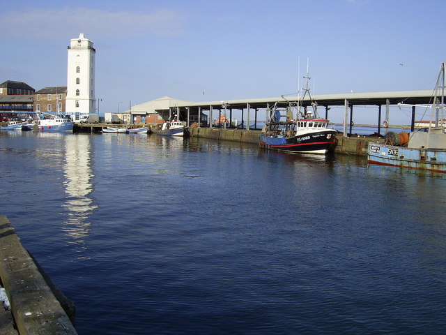
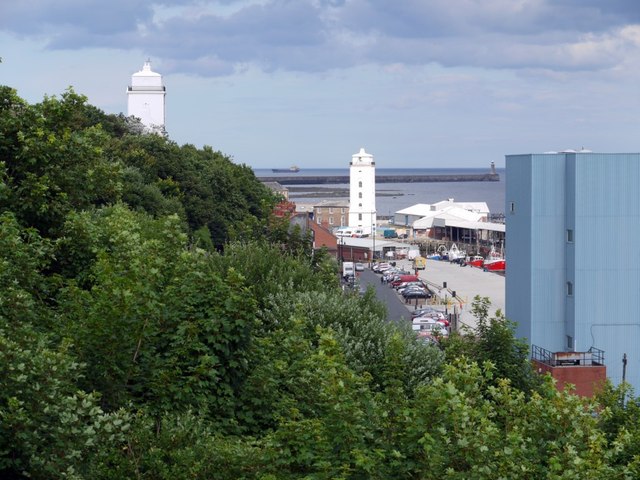
| Low Lighthouse and Building Attached to North | 1355017 | II | 1808 | Tynemouth | North Shields | Fish Quay |
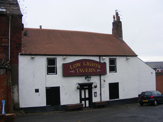
| Low Lights Tavern | 1355019 | II | C18th | Tynemouth | North Shields | Brewery Bank |
| Main Passenger Building of Tynemouth Old Railway Station | 1299917 | II | 1847 | Tynemouth | Tynemouth | |
| Marsden House | 1184551 | II | Tynemouth | |||
| Master Mariners' Homes | 1185201 | II | Tynemouth | |||
| Memorial Church, Social Centre and Ministers House | 1300159 | II | 1891 | Tynemouth | North Shields | Albion Road. Now Kiki's Kabin. |
| Milestone | 1421393 | II | Tynemouth | |||
| New High Light and House Attached | 1185198 | II | 1808 | Tynemouth | North Shields | |
| North Pier with Crane Attached and Lighthouse | 1025352 | II | Tynemouth | |||
| North Shields Mechanics Institute and Free Library | 1413269 | II | 1858 | Tynemouth | North Shields | Saville Street |
| Numbers 12-20 Consecutive Including Number 17a (Number 12 Includes Number 1) | 1025349 | II | Tynemouth | |||
| Old House | 1184557 | II | Tynemouth | |||
| Salvation Army Citadel (Scotch Church) | 1354988 | II | 1811 | Tynemouth | North Shields | Howard Street. By John Dobson. |
| South African War Memorial Opposite Number 2 | 1184607 | II | 1902 | Tynemouth | Tynemouth | Front Street |
| St Leonard's Hosptial Remains in Northumberland Park, About 15 Metres East and 32 Metres South of Park Lodge | 1025345 | II | Medieval | Tynemouth | Grave slab and coffins | |
| Statue of Duke of Northumberland, South of Master Mariners' Homes | 1025357 | II | Tynemouth | |||
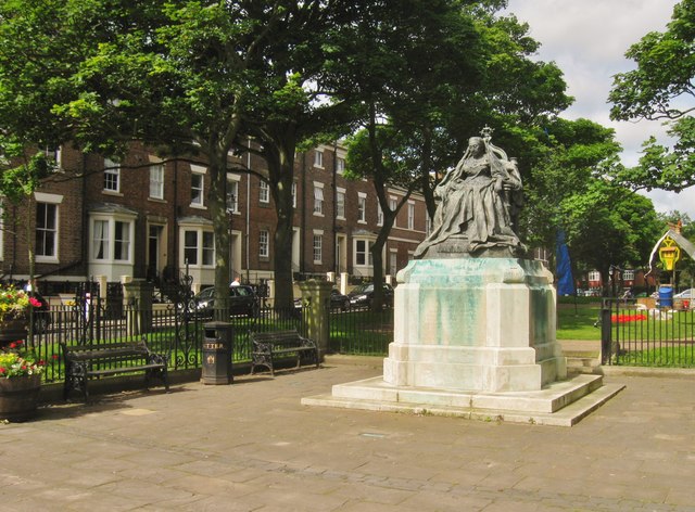
| Statue of Queen Victoria Opposite Number 10 | 1025374 | II | 1902 | Tynemouth | Tynemouth | Front Street |
| The Old Maltings | 1355014 | II | Tynemouth | |||
| Tomb in Style of Greek Temple About 20 Metres South of Tynemouth Priory | 1354987 | II | Tynemouth | |||
| Tynemouth Watch House | 1184976 | II | 1887 | Tynemouth | Tynemouth | Pier Road |
| Vicarage of St George | 1184427 | II | Tynemouth | |||
| Wall and Piers | 1185193 | II | Tynemouth | |||
| War Memorial outside St George's Church | 1411542 | II | Tynemouth | |||
| West House | 1355021 | II | Tynemouth | |||
| Wool House | 1025322 | II | Tynemouth | |||
| Wright Tomb About 12 Metres South of Presbytery of Tynemouth Priory Church | 1354986 | II | Tynemouth | |||
| Tynemouth Iron Age and Romano-British settlements, monasteries, site of lighthouse, cross, motte, enclosure and artillery castles and later coastal defences | 1015519 | n/a | Iron Age | Tynemouth | Scheduled Monument. Includes Tynemouth Priory and Castle | |
| Hadrian's Wall in wall mile 0, section between Eastfield Avenue and Tumulus Avenue | 1003506 | n/a | Roman | Wallsend | Scheduled Monument | |
| Church of St. Hilda | - | Local | 1966 | Cullercoats | Stanton Road | |
| Church Bank Cemetery and Buildings | - | Local | 1870s | Wallsend | ||
| Church of St. Peter | - | Local | 1930s | Monkseaton North | Elmwood Road | |
| Allen Memorial Church | - | Local | 1903 | Wallsend | Park Road | |
| Whitley Bay Baptist Church | - | Local | c.1910 | Whitley Bay | Park Avenue | |
| No. 1 Union Quay | - | Local | c.1840s | Tynenmouth | North Shields | Fish Quay |
| The Arcade | - | Local | c.1860s | Tynemouth | ||
| Nos. 9-11-13 Percy Park Road | - | Local | c.1880s | Tynemouth | ||
| No. 4 Percy Park Road | - | Local | c.1880s | Tynemouth | ||
| Nos. 2 - 6 High Street West | - | Local | 1883 | Wallsend | ||
| Nos. 105 - 109 High Street West | - | Local | 1924 | Wallsend | Early Art Deco | |
| No. 205 Park Road | - | Local | 1912 | Wallsend | ||
| No. 305 Whitley Road | - | Local | 1902 | Whitley Bay | Built for the North Shields Industrial Society. | |
| Verdemar House | - | Local | 1920s | Whitley Bay | 230 Park View | |
| Belvedere Building | - | Local | 1926 | Whitley Bay | ||
| Nos. 201-203 Whitley Road & 4 Station Road | - | Local | 1888 | Whitley Bay | ||
| Nos. 1-3 South Parade & 230-234 Whitley Road | - | Local | c.1900 | Whitley Bay | ||
| Nos. 86-116 Park View | - | Local | 1910 | Whitley Bay | ||
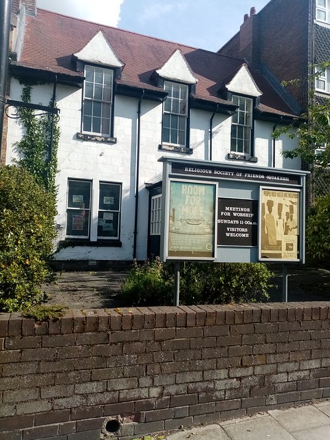
| Friends Meeting House | - | Local | C18th | Monkseaton South | Monkseaton | 23 Front Street |
| No. 52 Bell Street | - | Local | 1952 | Tynemouth | North Shields | |
| Tyne Steam Packet Provident Society Club House | - | Local | 1897 | Riverside | 1 Waldo Street/47 Sibthorpe Street | |
| No. 31 Station Road | - | Local | 1891 | Wallsend | ||
| Rake House Farm | - | Local | C19th | Collingwood | North Shields | Rake Lane |
| Burradon Farm Complex | - | Local | C19th | Camperdown | Burradon | Burradon Road |
| Nos. 1-4 West Avenue | - | Local | c.1890s | Benton | ||
| North View House | - | Local | C18th | Benton | Front Street | |
| No. 42 Beverley Terrace | - | Local | 1870 | Cullercoats | ||
| Nos. 1-3 Church Way | - | Local | C19th | Earsdon | ||
| Melrose House | - | Local | c.1860s | Benton | Forest Hall | 1 Park Drive |
| Hallington Mews | - | Local | 1968 | Camperdown | Killingworth | by Ralph Erskine, designer of Byker Wall |
| Monkseaton House | - | Local | c.1806 | Monkseaton North | 56 Front Street | |
| Knotts Memorial Flats | - | Local | 1939 | Tynemouth | North Shields | Tynemouth Road |
| Ashbury House | - | Local | 1890s | Tynemouth | North Shields | |
| Preston Cottage | - | Local | c.1810s | Preston | ||
| Nos. 1-6 Widdrington Terrace and 32 Newcastle Street | - | Local | c.1880s | Chirton | ||
| Nos. 7-8-9 Lovaine Terrace | - | Local | c.1850s | Preston | ||
| Former Quay Master's Office and House | - | Local | 1860s | Tynemouth | North Shields | Fish Quay |
| Nos. 1-7 Ferry Mews | - | Local | c.1850s | Riverside | North Shields | |
| Nos. 2-6 Trinity Buildings | - | Local | c.1887 | Tynemouth | North Shields | |
| Nos. 112-113 East View | - | Local | 1870s | Weetslade | Wideopen | |
| No. 10 Russell Square | - | Local | 1870s | Weetslade | Seaton Burn | |
| Nos. 1-8 Front Street Plus Lorne House and Broadstone | - | Local | C18th | Tynemouth | Front Street | |
| Pier Cottage | - | Local | c.1850s | Tynemouth | ||
| Nos. 1-47 Percy Gardens Plus The Lodge, Priory Court And Gardens | - | Local | c.1860s | Tynemouth | ||
| Priory Court and Gardens | - | Local | 1892 | Tynemouth | ||
| Nos. 5-8 Tynemouth Place | - | Local | C19th | Tynemouth | ||
| Nos. 1-6 Old Coastguard Cottages | - | Local | 1892 | Tynemouth | North Shields | |
| Nos. 6-7-8 Tynemouth Terrace | - | Local | c.1850s | Tynemouth | ||
| No. 1 Warkworth Terrace | - | Local | c.1860s | Tynemouth | ||
| Nos. 22, 24, 26, 28 Lovaine Row | - | Local | C18th | Tynemouth | ||
| Pickering House | - | Local | C19th | Tynemouth | 1 Pier Road | |
| Nos. 1-4 Spanish Battery | - | Local | 1895 | Tynemouth | North Shields | |
| No. 38 Percy Park | - | Local | c.1870s | Tynemouth | ||
| No. 3 Northumberland Terrace | - | Local | C19th | Tynemouth | ||
| No. 10 Priors Terrace | - | Local | C19th | Tynemouth | ||
| The Villa | - | Local | c.1857 | Wallsend | ||
| Park Villas | - | Local | c.1898 | Wallsend | ||
| Hawthorn Villas | - | Local | 1898 | Wallsend | ||
| Highfield House | - | Local | 1902 | Wallsend | 31 Kings Road South | |
| Nos. 89-96 Village Court Plus 1 & 2 The Clock Tower | - | Local | C19th | Whitley Bay | ||
| Marden House | - | Local | C19th | Whitley Bay | Marden Road South | |
| Nos. 103 To 108 The Links | - | Local | 1930s | St. Mary’s | art deco | |
| Nos. 31 To 37 (odds) Craneswater Avenue | - | Local | 1930s | St. Mary’s | art deco | |
| No. 11A Shaftesbury Avenue | - | Local | 1930s | Monkseaton North | art deco | |
| Nos. 12-34 (evens) Victoria Terrace | - | Local | C19th | Whitley Bay | ||
| Buttress House | - | Local | C19th | Weetslade | Seaton Burn | Brenkley Way |
| Dove Marine Laboratory | - | Local | 1908 | Cullercoats | ||
| Henson Service Centre | - | Local | 1964 | Camperdown | Killingworth | former Lions Brush Works |
| Caley Fisheries Ships Chandlers | - | Local | 1913 | Tynemouth | North Shields | Fish Quay |
| No. 131 Bedford Street | - | Local | 1874 | Riverside | North Shields | |
| Formica Ltd, West Chirton Industrial Estate | - | Local | c.1947 | Collingwood | North Shields | |
| Boat House and attached former morgue | - | Local | C19th | Tynemouth | Tynemouth Sailing Club Storage Hut | |
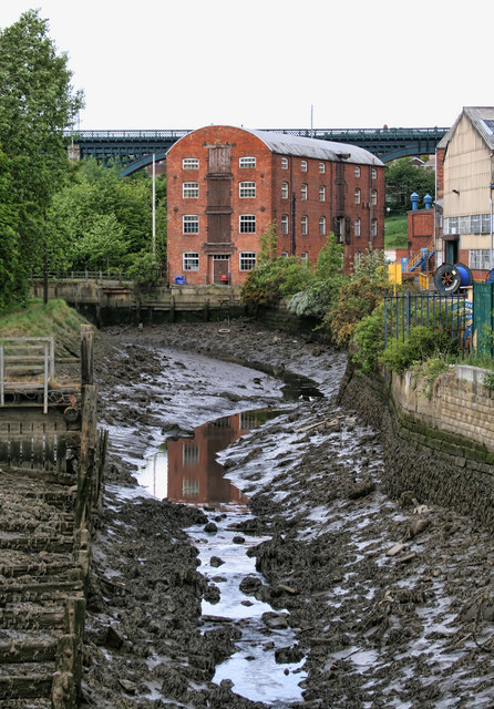
| Willington Mill | - | Local | 1805 | Riverside | Willington, Wallsend | By Willington Gut |
| Tesco Chimney | - | Local | 1940s | Chirton | West Chirton, North Shields | Norham Road |
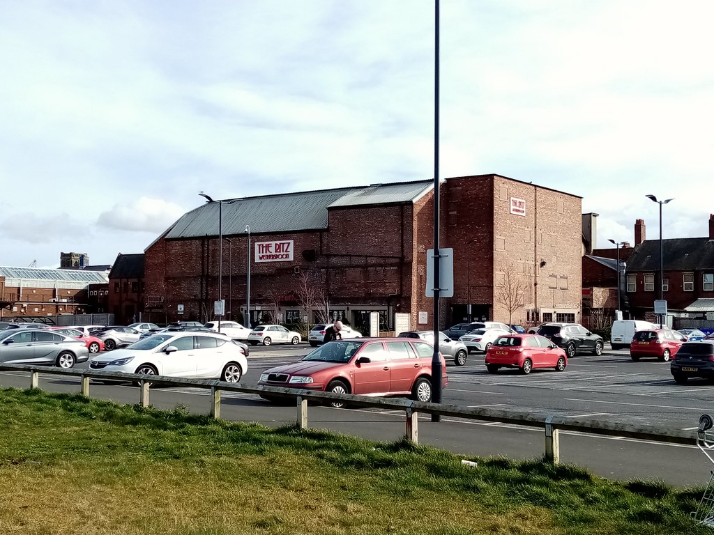
| Ritz Buildings (Forest Hall) | - | Local | 1936 | Benton | Forest Hall | Forest Hall Road |
| Tynemouth Open Air Pool | - | Local | 1925 | Tynemouth | Tynemouth | |
| The Ritz (Wallsend) | - | Local | 1939 | Wallsend | Wallsend | High Street West |
| Rendezvous Cafe | - | Local | 1930 | Monkseaton North | Whitley Bay | |
| Coliseum Building | - | Local | 1803 | Whitley Bay | Whitley Bay | 248 Whitley Road |
| Rex Hotel | - | Local | 1906 | Whitley Bay | Whitley Bay | Closed 2016 |
| Search Light - Priors Haven | - | Local | 1902 | Tynemouth | ||
| Backworth Miners Welfare Hall Gardens | - | Local | C18th | Valley | Backworth | |
| Backworth Green | - | Local | C18th | Valley | Backworth | |
| Chirton Green | - | Local | 1882 | Chirton | ||
| Springfield Park | - | Local | c.1940s | Benton | Forest Hall | |
| Killingworth Lake and Park | - | Local | 1964 | Killingworth | Killingworth | |
| Preston Cemetery | - | Local | 1856 | Preston | ||
| Northumberland Park | - | Local | 1885 | Tynemouth | King Edward Road | |
| Chirton Dene And Redburn Dene Parks | - | Local | 1990s | Riverside | ||
| Northumberland Square - North Shields | - | Local | C19th | Tynemouth | North Shields | |
| Tynemouth Green | - | Local | C18th | Tynemouth | Front Street | |
| Tynemouth Park | - | Local | 1890 | Tynemouth | Grand Parade | |
| The Hall Grounds including Victorian flued wall and grotto | - | Local | C19th | Wallsend | Kings Road South | |
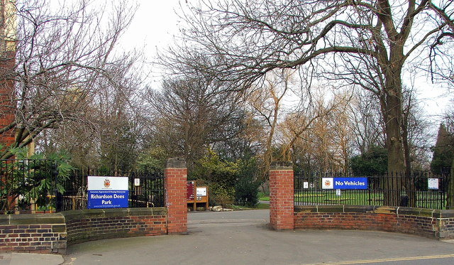
| Richardson Dees Park and Arboretum | - | Local | 1900 | Wallsend | Wallsend | North Road |
| Whitley New Cemetery | - | Local | c.1913 | St Mary's | The Links | |
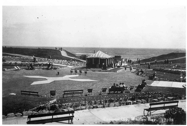
| Panama Gardens | - | Local | 1933 | Monkseaton North | Whitley Bay | The Links |
| Prince of Wales Tavern | - | Local | 1927 | Tynemouth | North Shields | Fish Quay |
| The Crane House | - | Local | 1905 | Riverside | North Shields | Duke Street |
| The Pub and Kitchen | - | Local | C19th | Riverside | North Shields | 13 - 14 Albion Road |
| Berwick Arms | - | Local | C19th | Riverside | North Shields | Trinity Street |
| Garricks Head | - | Local | 1898 | Riverside | North Shields | 44 - 52 Saville Street |
| Wolsington House | - | Local | 1902 | Riverside | North Shields | Dock Road Industrial Estate |
| Cumberland Arms | - | Local | 1898 | Tynemouth | Tynemouth | 17 Front Street |
| Salutation Inn | - | Local | C18th | Tynemouth | Front Street | |
| Dolphin Inn | - | Local | 1930s | Tynemouth | King Edward Road | |
| Rising Sun Inn | - | Local | 1930s | Wallsend | Wallsend | Coast Road |
| Duke of York | - | Local | C20th | Wallsend | 179 High Street West | |
| The Anchor | - | Local | C20th | Wallsend | 166 High Street West | |
| Queen’s Head | - | Local | C19th | Wallsend | 140 High Street West | |
| Manhattan | - | Local | C19th | Wallsend | 85 - 87 High Street West | |
| Rose Inn | - | Local | c.1913 | Wallsend | Rosehill, Rosehill Bank | Rosehill Bank |
| New Winning Tavern | - | Local | 1894 | Wallsend | Church Bank | |
| The Fat Ox | - | Local | 1923 | Whitley Bay | 278 Whitley Road | |
| Travellers Rest | - | Local | 1930s | Weetslade | Wideopen | Great North Road |
| Richardson Dees Primary School | - | Local | 1902 | Wallsend | High Street East | High Street East |
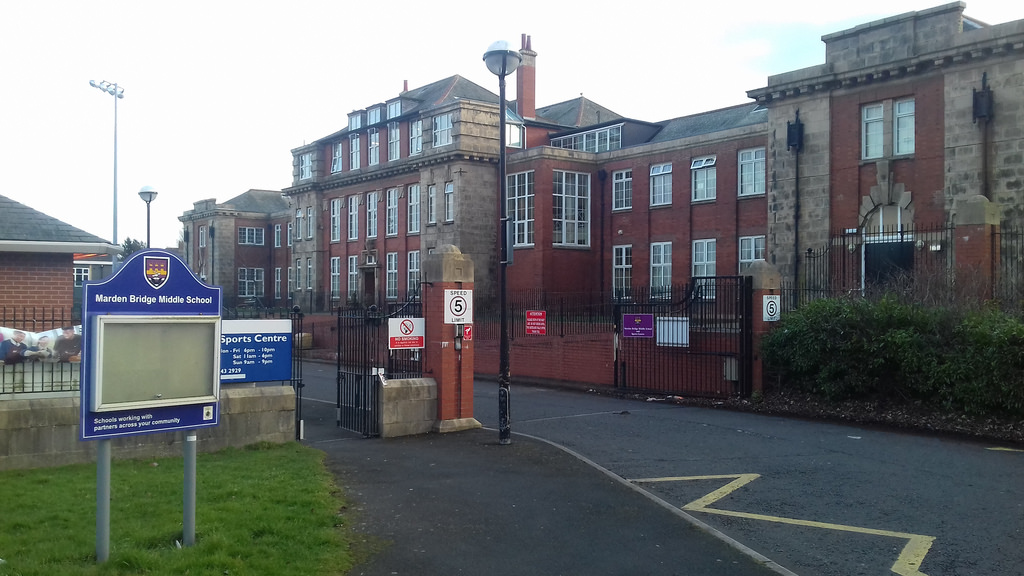
| Marden Bridge Middle School | - | Local | 1914 | Whitley Bay | Lovaine Avenue | |
| Cattle Trough | - | Local | 1927 | Monkseaton North | Relton Terrace | |
| Lion's Head Fountain | - | Local | 1863 | Tynemouth | Buried under the sand at Tynemouth Longsands | |
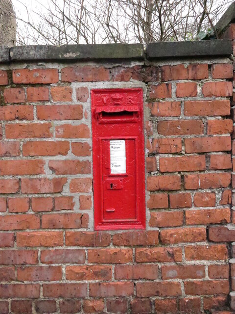
| Victorian Post Box - Lily Bank | - | Local | C19th | Wallsend | ||
| Victorian Post Box - Engine Inn Road | - | Local | C19th | Howdon | ||
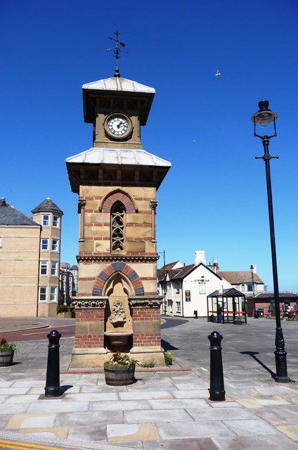
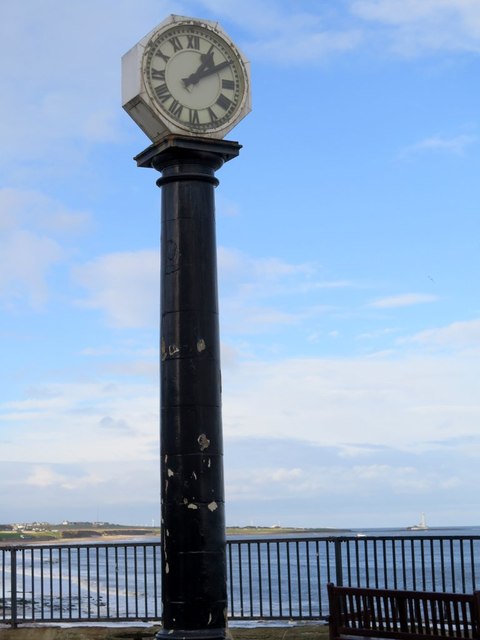
| Grant's Clock | - | Local | 1933 | Whitley Bay | Promenade | |
| Victorian Post Box - Hillheads Road | - | Local | C19th | Whitley Bay | ||
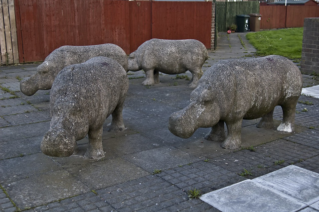
| Killingworth Hippopotami | - | Local | 1970s | Killingworth | Killingworth | Garth Twenty Two |
| Jigsaw Memorial - White Swan Centre | - | Local | 2000 | Killingworth | Killingworth | |
| Benton Metro Station | - | Local | 1871 | Benton | Former railway station | |
| Cullercoats Metro Station | - | Local | 1882 | Cullercoats | Former railway station | |
| Monkseaton Metro Station | - | Local | 1915 | Monkseaton South | Whitley Bay | Former railway station |
| West Monkseaton Metro Station | - | Local | 1933 | Monkseaton North | ||
| Linskill Centre | - | Local | 1932 | Tynemouth | North Shields | |
| No. 21 Front Street | - | Local | C18th | Tynemouth | ||
| Nos. 26 and 28 Great Lime Road | - | Local | C19th | Killingworth | West Moor | |
| No. 2 Connaught Gardens/51 Station Road | - | Local | c.1900 | Benton | Forest Hall | |
| Nos. 53-55 Park View | - | Local | 1930s | Whitley Bay | ||
| No. 70 Whitley Road | - | Local | c.1890s | Whitley Bay | Bluebells | |
| Beacon House | - | Local | 1962 | St Mary's | Whitley Bay | |
| Earsdon Community Centre | - | Local | C19th | St Mary's | Earsdon | |
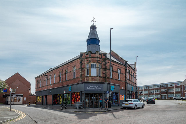
| N.E. Co-Op | - | Local | 1895 | Cullercoats | Cullercoats | John Street |
| No. 28 Tynemouth Road | - | Local | 1792 | Tynemouth | North Shields | Former House of Correction |
| War Memorial At Church Bank Cemetery | - | Local | 1920s | Wallsend | ||
| Cross of Sacrifice at Preston Cemetery | - | Local | 1927 | Preston | ||
| No. 16 Bygate Road | - | Local | C18th | Monkseaton South | ||
| Liddell House | - | Local | 1958 | Tynemouth | 1F Grand Parade | |
| The remains of the Old Monkseaton Brewery Wall, situated adjacent to the Monkseaton Arms | - | Local | 1683 | Monkseaton North | ||
| Monkseaton Village Methodist Church | - | Local | C18th | Monkseaton South | C18th | Front Street |
| Oceana Business Park | - | Local | C20th | Wallsend | Former Wallsend Research Station | |
| Park Hotel | - | Local | 1938 | Tynemouth | Art Deco | |
| North and South Piers, Cullercoats Bay | - | Local | C19th | Cullercoats | ||
| Post Box - Forest Hall Road | - | Local | C20th | Benton | Forest Hall | |
| Post Box - Northumberland Terrace | - | Local | C19th | Tynemouth | ||
| Old Post Office | - | Local | 1889 | Tynemouth | North Shields | 63 Saville Street |
| Preston Towers | - | Local | 1875 | Preston | Preston Road | |
| Three private graves - Benton Cemetery | - | Local | C19th | Benton | Benton | |
| Horse trough | - | Local | c.1900 | Benton | West Moor | off Great Lime Road |
| Ryder House | - | Local | 1956 | Longbenton | 98A Stoneleigh Avenue | |
| Signpost - Junction of Fisher Road | - | Local | C19th | Valley | Backworth | |
| Nos. 28-74 (evens) Simpson Street | - | Local | C19th | Cullercoats | ||
| Spital Dene House | - | Local | C18th | Tynemouth | King Edward Road | |
| St. Andrew’s Church | - | Local | 1904 | Longbenton | Benton | |
| Stone of Remembrance - Preston Cemetery | - | Local | c.1950 | Preston | ||
| The Ship Inn | - | Local | 1904 | Benton | Benton | Front Street |
| The Villa, 26 Front Street | - | Local | c.1830s | Weetslade | Seaton Burn | |
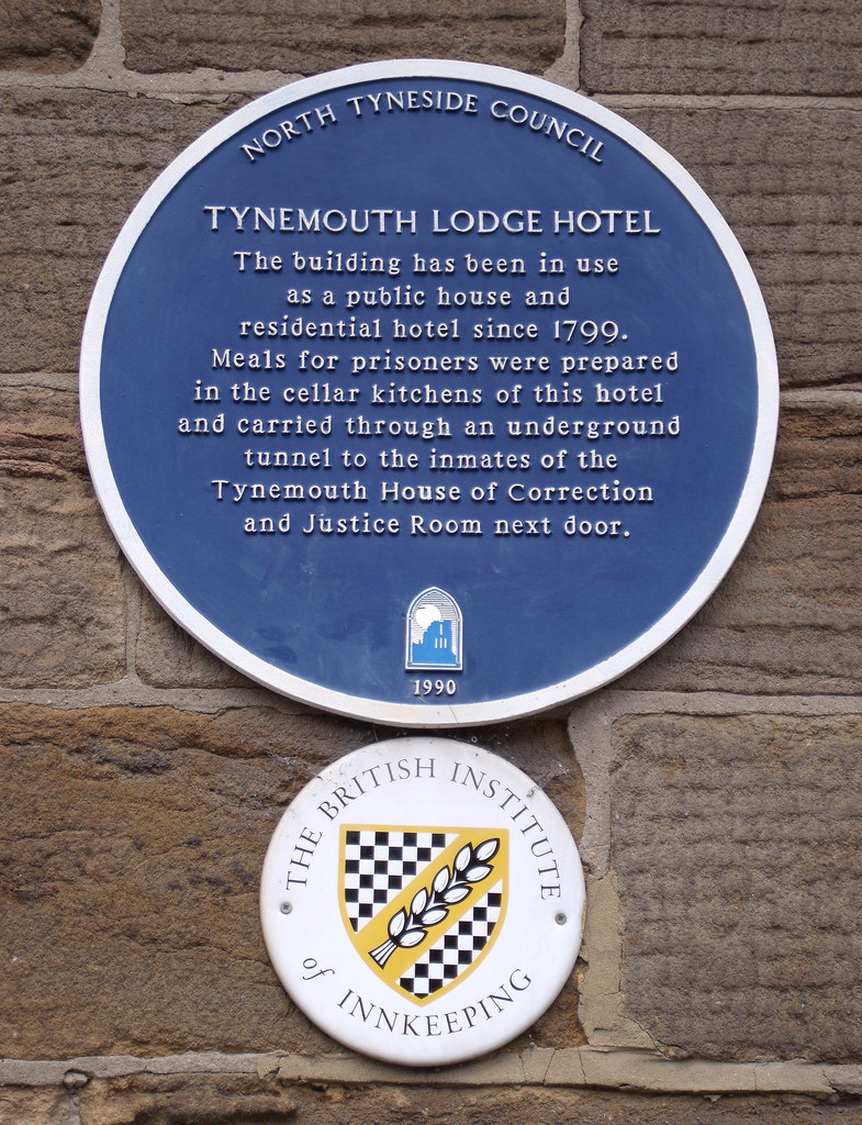
| Tynemouth Lodge Hotel | - | Local | 1799 | Tynemouth | North Shields | Tynemouth Road |
| Water Hydrant - Westmorland Street | - | Local | c.1900 | Wallsend | ||
| The Winding House - Fenwick Colliery | - | Local | 1946 | Valley | East Holywell | |
| No. 1 King Edward Road | - | Local | C18th | Tynemouth | ||
| No. 58 Front Street | - | Local | C15th | Monkseaton North | C19th remodelling | |
| Beach Bingo, Russell Street | - | Local | 1929 | Riverside | North Shields | |
| Sterling Pharma Solutions | - | Local | 1972 | Weetslade | Dudley | |
| Post Box at junction with Jackson Street | - | Local | C19th | Tynemouth | North Shields | |
| Blocks E, F, J, L, M, N, S and Plant 1 and 2, Engineering Research Station | - | Local | 1966 | Camperdown | Killingworth | |
| Concrete Pillar - St Mary's Island | - | Local | 1914 | St. Mary’s | ||
| Tritek House - Stephenson Industrial Estate | - | Local | 1960s | Camperdown | Killingworth | |
| Ryder and Yates’ Office | - | Local | 1965 | Camperdown | Killingworth |
1. Primary source: the National Heritage List for England - NHLE is the register of nationally protected historic buildings and sites in England, including listed buildings, scheduled monuments, protected wrecks, registered parks and gardens, and battlefields. The list is maintained by Historic England. Check NHLE for updates and new entries.
Secondary sources: British Listed Buildings and Sitelines.
2. Listed buildings and the local list - North Tyneside Council.
Co-Curate Page
Accumulator Tower, Albert Edward Dock
- Overview Map Street View The hydraulic accumulator tower is located in what today is the Royal Quays Marina in North Shields. The 2 story tower was built in 1882 for …

Co-Curate Page
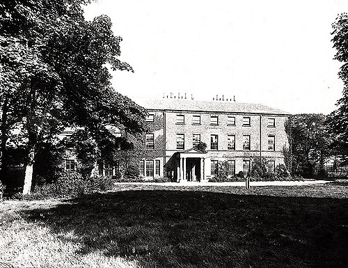
Former British Gas Engineering Research Station
- Overview Map Street View This former British Gas Research Station is located off Station Road in Killigworth. It was originally built 1966-1967, designed by Ryder and Yates, and extended. It …
Co-Curate Page
Dial Cottage, West Moor near Killingworth
- Overview Map Street View The plaque above the door of Dial Cottage reads: "George Stephenson engineer. Inventor of the Locomotive Engine lived in this cottage from (1805 to 1823), his …
Co-Curate Page
Church of St George
- Overview About the Church Map Street View The Parish Church in Cullercoats was built between 1882 and 1884 by the Duke of Northumberland in memory of his father George Percy, …

Co-Curate Page
Tynemouth Station
- Overview About the Station History Map Street View Tynemouth Station opened on 7th July 1882. It was designed by William Bell for the North Eastern Railway Company (NER). It replaced …
Co-Curate Page
Beehive Inn, nr Earsdon
- Overview Map Street View The Beehive is a pub near Whitley Bay. It is located on Hartley Lane (the B1325) half a mile north east of Earsdon and 2.5 miles …
Co-Curate Page
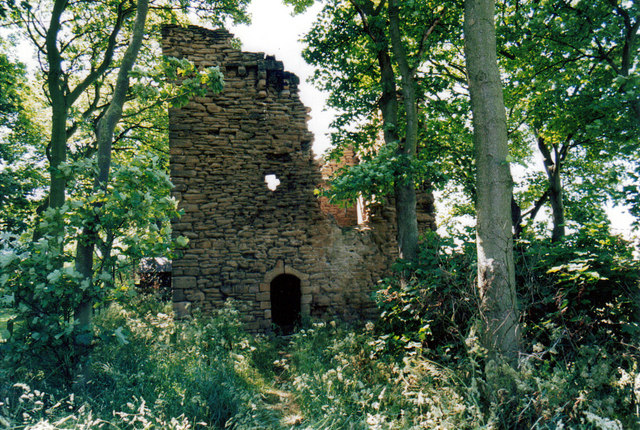
Burradon Tower
- Overview About Burradon Tower Map Burradon Tower is a ruined Pele Tower (defensive tower) in Burradon, built during times of hostilities with Scotland. The Tower is a Grade II listed …
Co-Curate Page
Christ Church
- Overview About Christ Church Map Street View Christ Church, North Shields, Tyne and Wear, England is an Anglican church in the parish of North Shields Christ Church, diocese of …
Co-Curate Page
Church of St. Alban
- Overview Map Street View The Parish Church at Earsdon was built 1836-1837, on the site of a much earlier 13th century church. The church was designed by John & Benjamin Green, …
Co-Curate Page
Church of St Bartholomew
- Overview About the Church Map Street View St Bartholomew's Church is located off Station Road in Longbenton. The parish church is on a Medieval site dating back to at least …
Co-Curate Page
Church of St. Edward
- Overview Map Street View St Edward’s Roman Catholic Church on Coquet Avenue in Whitley Bay was built 1926-1928 to the designs of Stienlet & Maxwell of Newcastle. It was opened …
Co-Curate Page
Edward Eccles Church Hall
- Overview Map Street View The Hall, which belongs to St Alban's Church, is located at the west edge of Earsdon. Designed by Wilkinson and Crawley, it was built 1910-1911 and …
Co-Curate Page
Church of St Paul
- Overview Map Street View St Paul's Parish Church on Park View in Whitley Bay was built in 1864 by Salvin, and paid for by the Duke of Northumberland. The west …
Co-Curate Page
Clock Tower
- Overview Map Street View The distinctive clock tower and drinking fountain is located at the head of Front Street in Tynemouth, close to Tynemouth Priory. The Venetian Gothic style clock tower …
Co-Curate Page
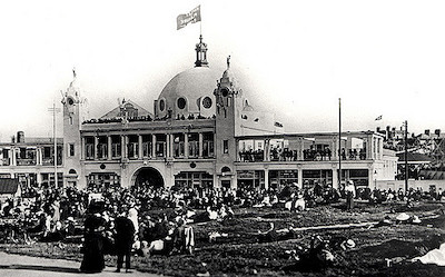
Spanish City
- Overview About Map Street View In c.1904 Charles Elderton, of Hebburn Theatre Royal, started bringing the "Toreadors" concert party to perform at Whitley Bay. Following repeated success, he established a …
Co-Curate Page
Rendezvous Cafe
- Overview Map Street View The iconic Art Deco style cafe at Duke's Walk by the North Promenade was built in June 1930 by Whitley Bay & District Council, and originally …
Co-Curate Page
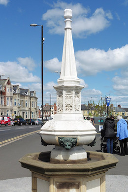
Coronation Fountain, North Promenade
- Plaque reads: "This drinking fountain was erected on 12th May 1937 to commemorate the coronation of T. M. King George and Queen Elizabeth". The fountain is Grade II listed as …

Co-Curate Page
Church of St Luke
- Overview Map Street View St Luke's Parish Church in Wallsend is located on the corner of Frank Street and Station Road. The church was built 1885-1887 by Oliver, Leeson and …
Co-Curate Page
Church of St Peter
- Overview Map Street View The Church of St. Peter in Wallsend was built in 1809 and extensively modified in 1892. The church is Grade II* listed on the National Heritage …
Co-Curate Page
Holy Cross Church (ruins)
- Overview Map Street View The Holy Cross Church, located near Valley Gardens in Wallsend dates from the mid 12th century. It was the chapel for Wallsend in the parish of …
Co-Curate Page
NEM Hammer-head Crane
- The giant 'NEM Hammerhead Crane' in Wallsend was built for the North Eastern Marine Engineering Company in 1909. At the time it was built, it was said to be the largest crane …
Co-Curate Page
Buddle Arts Centre
- Overview Map Street View Buddle Arts Centre is located on Station Road in Wallsend. The building was originally Buddle School or Wallsend Board Schools (for juniors and infants), completed in 1876 and …
Co-Curate Page
Coach & Horses
- Overview Map Street View The Coach and Horses in Wallsend is a public house located on the junction of High Street East and Coach Road. The pub was built c.1907 …
Co-Curate Page
Market Woman
- Sculpture of a Roman Woman by Hans Schwarz (1922-2003) in Wallsend. The sculpture was commissioned by J Seymour Harris and Partners, developers of the Forum shopping centre, and was unveiled …
Co-Curate Page
Town Hall
- Overview Map Street View The Town Hall, now a Business and a Conference Centre, were built 1907-8 by E.F.W. Liddle and P.L. Brown for the Borough of Wallsend. The Town …
Co-Curate Page
Old Wallsend Library, Ferndale Avenue
- Overview Map Street View The former Library on Ferndale Avenue in Wallsend was built 1965-1966, designed by Harry Faulkner Brown. The library closed on the 15th February 2014, and was …
Co-Curate Page
War Memorial
- The War Memorial for the Borough of Wallsend is located off Archer Street. It is a tall granite obelisk topped with a bronze angel of victory. The panel on the …
Co-Curate Page
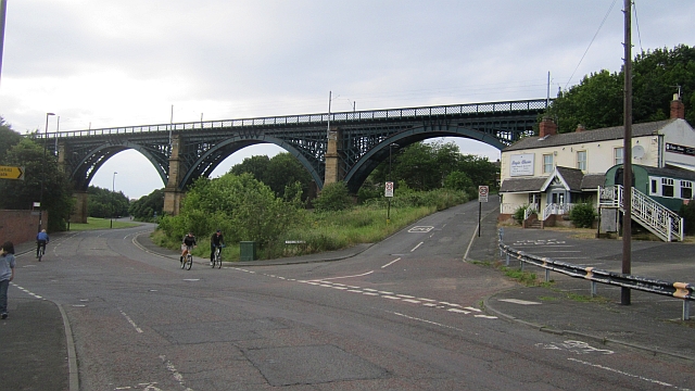
Willington Dene Viaduct
- Overview Map Street View Willington Dene Viaduct is a railway bridge over the valley of Wallsend Burn near Willington and Wallsend. It was built between 1837-1839 by John and Benjamin Green …
Co-Curate Page
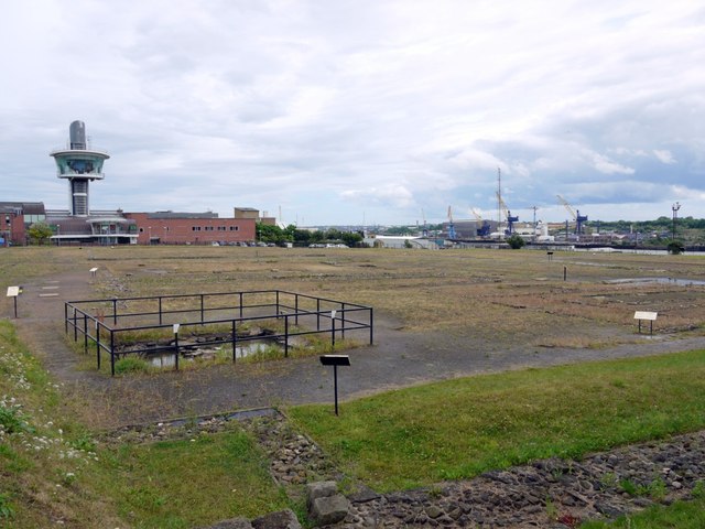
Segedunum
- Overview About Segedunum Map Segedunum was a Roman fort built at the eastern end of Hadrian's Wall near the banks of the River Tyne. It is located in modern-day Wallsend, …
Co-Curate Page
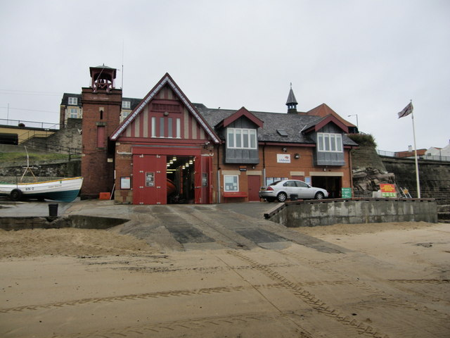
Cullercoats Lifeboat Station
- Overview Map Street View The first lifeboat in Cullercoats was funded by the Duke of Northumberland. This became operational in 1852 following the establishment of The Royal National Lifeboat Institution (RNLI) …

Co-Curate Page
Cullercoats Metro Station
- Overview About Map Street View The Metro station at Cullercoats was originally a railway station, which opened on the 7th July 1882. The station was built by the North Eastern …
Co-Curate Page
Dove Marine Laboratory
- Overview About Map Street View The first laboratory at Cullercoats was constructed by the Northumberland Sea Fisheries Committee and opened on the 21st of October 1897.[1] It was a small wooden …
Co-Curate Page
Church of the Holy Saviour
- Overview Map Street View Holy Saviour's Church on The Broadway/Crossway in Tynemouth was built 1839 to 1841 by John Green and Benjamin Green for the Duke of Northumberland. The parish …
Co-Curate Page
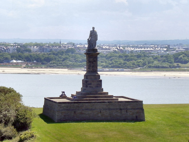
Collingwood Monument
- Overview About the Monument Map Street View The Collingwood Monument was built in 1845 in honour of Admiral Lord Collingwood, who led the British Fleet to victory at the Battle …
Co-Curate Page
Land of Green Ginger
- Overview Map Street View The former Congregational Church on Front Street in Tynemouth was built in 1868 by Thomas Oliver. The adjoining Church Hall was built in 1886.[1] In the …
Co-Curate Page
Statue of Queen Victoria
- Overview Map Street View The bronze memorial statue of Queen Victoria on Front Street in Tynemouth was by Alfred Turner and built in 1902. It was paid for by public …
Co-Curate Page
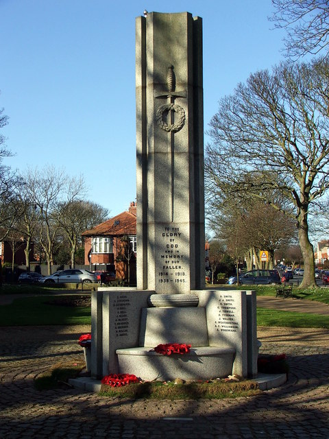
War Memorial
- Overview Map Street View The First World War Memorial in Tynemouth is located in the centre of the park by Front Street, between the Statue of Queen Victoria and the …
Co-Curate Page
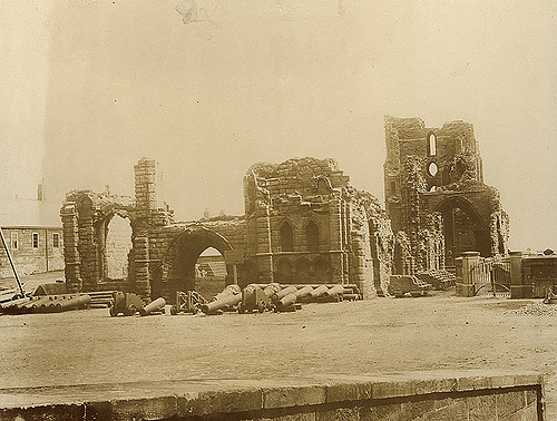
Tynemouth Priory and Castle
- Overview History Aerial View Street View Tynemouth Castle is located on a rocky headland (known as Pen Bal Crag) at Tynemouth, overlooking Tynemouth Pier and the mouth of the River …

Co-Curate Page
Tynemouth Pier and Lighthouse
- Overview Map Street View Work on the North Pier in Tynemouth began in 1854 and on the South Pier (in South Shields) in 1856. Both piers were originally constructed in …
Co-Curate Page
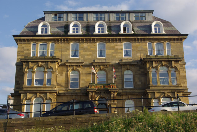
Grand Hotel
- Overview Map Street View The Grand Hotel is located on Grand Parade, by the sea front at Tynemouth. It was originally built in 1872 as seaside house for Duchess of …
Co-Curate Page
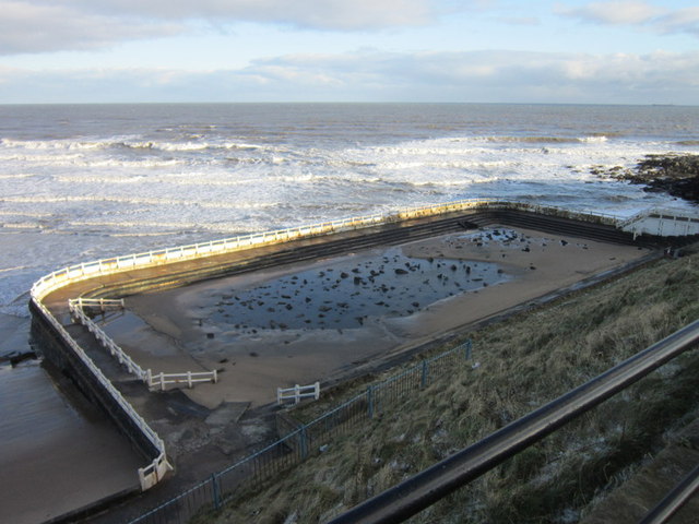
Tynemouth Outdoor Swimming Pool
- Overview Map Street View "Tynemouth outdoor swimming pool was first opened on 30th May 1925 and was once one of the area’s favourite and most prestigious attractions. It was automatically …
Co-Curate Page
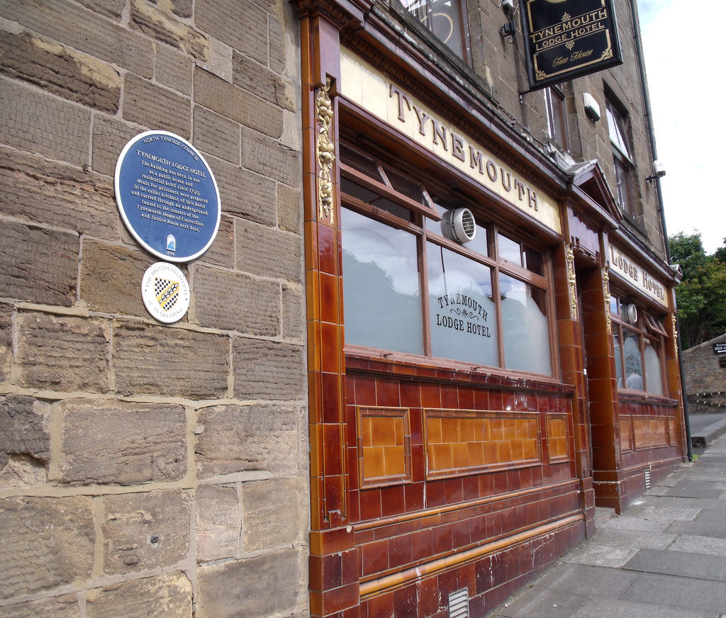
Tynemouth Lodge Hotel
- Overview Map Street View Inside The Tynemouth Lodge Hotel is a traditional pub on Tynemouth Road in North Shields (non residential), located by Northumberland Park, close to Tynemouth. "This building …
Co-Curate Page
Clock on Buddle Street
- Overview Map Street View This Gothic-style cast iron clock is by the junction of Buddle Street and Station Road, near Segedunum in Wallsend. It was built in the late 19th …
Co-Curate Page
The Ritz, Wallsend
- Overview Map Street View The Ritz is a public house on High Street West in Wallsend. It was originally the Ritz Cinema, which opened on the 15th of May 1939 …
Co-Curate Page
Rising Sun Inn
- Overview Map Street View The Rising Sun is a public house by the Coast Road in Wallsend. It was built in the 1930's to serve the new community in the …
Co-Curate Page
Public Baths, Wallsend
- Overview Map Street View The former public baths in Wallsend are located on Lawson Street, behind the Town Hall. The 'Restrained Baroque' style building was built by E.F.W Liddle and …
Co-Curate Page
Look-out Post & Gun Emplacement, Percy Gardens
- Overview Map Street View 47A Percy Gardens (west side) in Tynemouth is a former lookout post and gun emplacement built in c.1916, during the First World War. It is a …
Co-Curate Page
Bay View House (former Rex Hotel)
- Overview Map Street View Bay View House is located on the corner of Promenade and South Parade in Whitley Bay. This is the former 70 bedroom Rex Hotel, which closed in 2016. …
Co-Curate Page
Drinking Fountain, St Paul's Church
- The old drinking fountain, dated 1864, is built into the boundary wall of St Paul's Church in Whitey Bay. It is Grade II listed on the National Heritage List for …
Co-Curate Page
N.E. Co-op, John Street
- Overview Map Street View "This building was opened in 1895 by the North Shields Co-operative Society, subsequently North Eastern Co-operative Society. It is still in use by the Co-op. The building …
Co-Curate Page
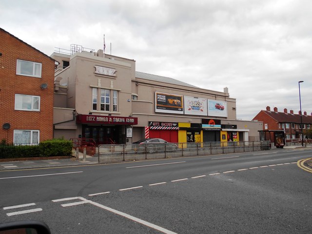
The Ritz, Forest Hall
- Overview Map Street View The 'Ritz' Bingo & Social Club in Forest Hall was originally a cinema. The Ritz cinema, with 1,062 seats, opened on the 9th November 1936 with …
Co-Curate Page
New York War Memorial
- Overview Map Street View The war memorial on Murton Lane in New York in inscribed with the names of 68 local servicemen from the district who lost their lives in the …
Co-Curate Page
War Memorial
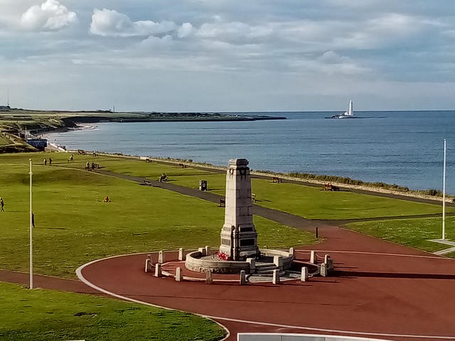
- Overview Map Street View The Cenotaph in Whitley Bay is located on the Links, by the Empress Gardens, close to Spanish City. The memorial was officially unveiled on the 15th …
Co-Curate Page
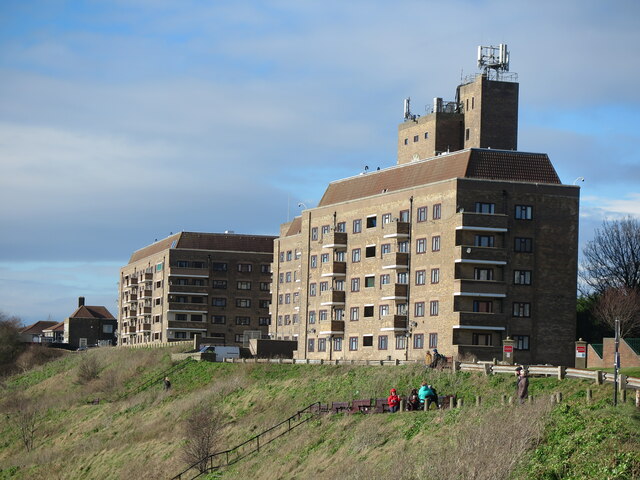
Sir James Knott Memorial Flats
- Overview Map Street View The Sir James Knott Memorial Flats on Tynemouth Road, overlooking the mouth of the Tyne, in North Shields and close to Tynemouth, were opened in 1939. …
Co-Curate Page
Old Tynemouth Station
- Overview Map Street View The first railway station in Tynemouth was opened on the 20th of March 1847 by the Newcastle and Berwick Railway. The station buildings were designed by …
Co-Curate Page
Cumberland Arms, Tynemouth
- Overview Map Street View The Cumberland Arms is located at 17 Front Street, Tynemouth. It is a red brick and faience Victorian gothic-style public house, which was built in 1898 …

Co-Curate Page
Monkseaton Station
- Overview About Map Street View The railway station at Monkseaton opened 25th July 1915, replacing the former Whitley Junction station of 1860, which was located in what is now Souter Park. …
Co-Curate Page
Grants Clock
- Overview Map Street View There is a clock with 2 faces located on the Promenade in Whitley Bay, close to the junction with South Parade. The clock stands on a …
Co-Curate Page
Northumberland Square
- Overview Map Street View Northumberland Square was the centrepiece of the 'New Town' development of North Shields built in the late 18th and early 19th century.
Co-Curate Page
Wallsend Hall
- Overview Memorial Hospital Map Street View Wallsend Hall is located on The Green in Wallsend. The house was built in the early 19th century and had significant grounds. The Hall …
Co-Curate Page
Church of St John the Evangelist
- Overview Map Street View The Church of St John the Evangelist is located on West Lane in Killingworth Village. Killingworth had been part of the parish of Longbenton, but became …
Co-Curate Page
Killingworth Hippopotami
- Overview Map Concrete Hippos by Stan Bonnar (b.1948), located at Garth 22, Killingworth. The sculpture is on the Register of Buildings and Parks of Local Architectural and Historic Interest ('Local List') …
Co-Curate Page
Old Fire Station, Wallsend
- Overview Map Street View The old Fire Station is located on Lawson Street in Wallsend. It was built in c.1908 by E.F.W. Liddle and P.L. Brown for the Borough of Wallsend. …
Co-Curate Page
Church of St Mary The Virgin, Willington
- Overview Map Street View The Church of St Mary the Virgin is located on Churchill Street in Willington was built in 1876 by Austin and Johnson. The parish church is …
Co-Curate Page
Willington Mill
- Overview Map Street View Willington Mill is situated by Willington Gut and located on Gut Road, off Ropery Lane. Constructed around 1805, this is a four-storey brick-built corn mill with …
Co-Curate Page
War Memorial, Shiremoor
- Overview Map Street View The War Memorial in Shiremoor is located off Emmerson Place. The memorial is a statue of a Northumberland Fusilier resting on reversed rifle, on tall column.[1] …
Co-Curate Page
Old Signpost, Shiremoor
- This "finger post" at the junction of Park Lane and Earsdon Road, in Shiremoor, dates from the later C19 or early C20. It was manufactured by the firm of Smith, …
Co-Curate Page
The Ship Inn, Benton
- Overview Map Street View Inside The Ship Inn on Front Street in Benton dates from 1904. The Ship Inn is listed on North Tyneside Council's register of buildings and parks …
Co-Curate Page
North House, Benton
- Overview Map Street View North House is located on Front Street in Benton, within the Longbenton Conservation Area, and believed to be the site of a vicarage since 1343. The …
Co-Curate Page
Church of St Augustin
- Overview Map Street View St Augustin's Church is located by the junction of Jackson Street and Washington Terrace in North Shields. It was designed as a replica of St Andrew’s …
Co-Curate Page
Church of St. Columba, North Shields
- Overview Map Street View St Columba's United Reformed Church is located on Northumberland Square (no. 30) in North Shields. It was originally built as a Presbyterian Church, designed in an …
Co-Curate Page
Mechanics Institute and Free Library
- Overview Map Street View The former Free Library is located on Howard Street by the junction with Saville Street, North Shields. The Mechanics Institute was built 1857-1858, designed by John …
Co-Curate Page
Low Lights Tavern, North Shields
- Overview Map Street View Low Lights Tavern is located on Brewhouse Bank, North Shields. It was originally built as a house in the late 18th Century, and later converted for …
Co-Curate Page
Hodgson Tomb, Christ Church, North Shields
- Overview Map Street View This old sandstone chest tomb of c.1690 is located in the churchyard of Christ Church, by Preston Road in North Shields. This is the tomb of …
Co-Curate Page
Panama Gardens
- Overview Map Street View In October 1932 Whitley & Monkseaton Urban District Council discussed a scheme for sunken gardens on The Links between Watts Road and Panama House (a cafe …
Co-Curate Page
House of Correction
- The former Tynemouth House of Correction and Justice Room on Tynemouth Road in North Shields was built in 1792. It was converted into a workshop in 1906 and significantly altered …
Co-Curate Page
Salvation Army Citadel
- Overview Map Street View The Salvation Army Citadel is located at no. 28 Howard Street, North Shields. It was originally built in 1811 as Scotch Church, designed by John Dobson. The …
Co-Curate Page
Kiki's Kabin (former church)
- Overview Map Street View Kiki's Kabin is located on Albion Road, North Shields. This children's play centre is a former non-conformist church. The Church, Sunday School and minister's house was …
Co-Curate Page
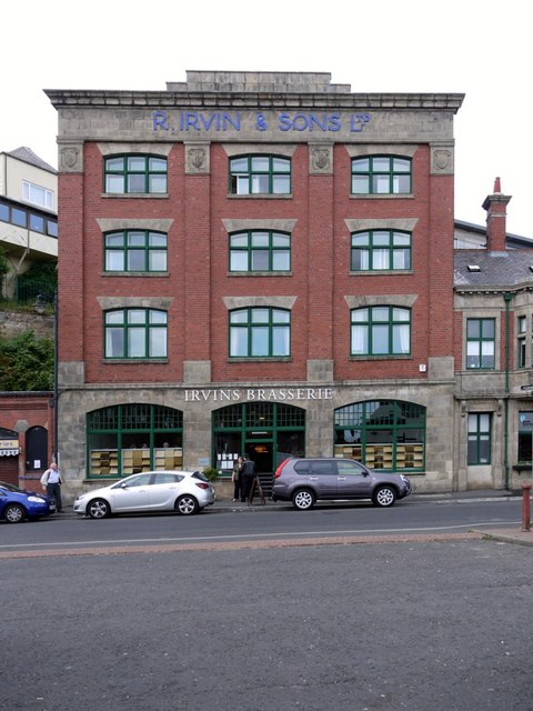
Irvin's Building
- Overview Map Street View The Irvin Building is located on Union Road on the North Shields Fish Quay. It was built in 1913 for Richard Irvin and Sons Ltd., who …
Co-Curate Page
Old Low Light
- Overview Map Street View The Old Low Light is a heritage centre and cafe located at the Fish Quay in North Shields. It was originally built as a lighthouse in …
Co-Curate Page
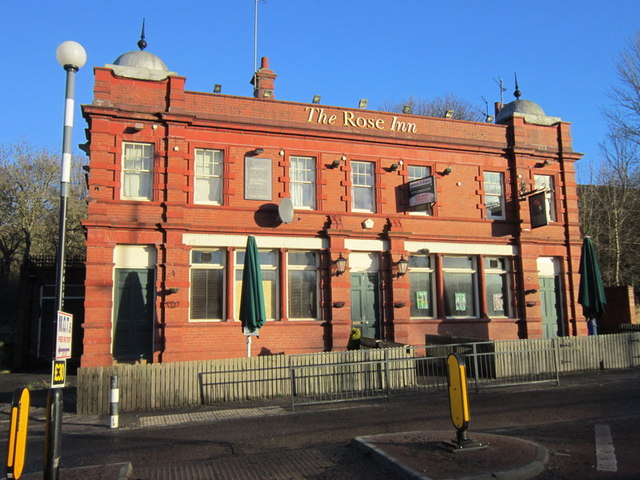
Rose Inn, Rosehill Bank
- Overview Map Street View The Rose Inn is a public house located on Rosehill Bank in the Rosehill area of Wallsend. The ornate terracotta two storey public house opened in …
Co-Curate Page
Low Light
- Overview Map Street View The "New" Low Light on North Shields Fish Quay was built 1805-1808 by Trinity House and first lit in 1810.[1]. In conjunction with the High Light in …
Co-Curate Page
High Light
- Overview Map Street View The "New" High Light, on Tyne Street, North Shields was built in 1807, designed by John Stokoe for Trinity House, and first lit in 1810.[1] In conjunction with the Low Light on the North Shields Fish Quay, …
Co-Curate Page
Ballards Smoke House, Fish Quay
- Overview Map Street View Ballards Smoke House is located in the Fish Quay area of North Shields. At first glance it looks like a modern building with its distinctive contemporary …
Co-Curate Page
Low Dock, Liddell Street, North Shields
- Overview Map Street View Low Dock, off Liddell Street in North Shields dates from the early 19th century. It is the oldest surviving graving dock on Tyneside. Low Dock is …
Co-Curate Page
Ethel Williams Hall, Front Street
- Overview Map Street View Ethel Williams Hall is located on Front Street in Benton. The house was built in c.1734 for C. Hayton. The building was used as a vicarage …
Co-Curate Page
Jasmine House, The Green, Wallsend
- Overview Map Street View Jasmine House is located on The Green, by the junction with Crow Bank, in Wallsend. It dates from the mid to late 18th century and is …
Co-Curate Page
Cross House, The Green, Wallsend
- Overview Map Street View Cross House is located on The Green in Wallsend. Dame Eleanor Allan (founder of Dame Allan's school in Newcastle) taught for short period in the house. …
Co-Curate Page
Wallsend Health Centre, The Green, Wallsend
- Overview Map Street View The Village Green Surgery (aka Wallsend Health Centre) is located next to Wallsend Hall, on The Green in Wallsend. Pre-dating the creation of the National Health …
Co-Curate Page
Richardson Dees Primary School
- Overview Map Street View Richardson Dees Primary School is located on High Street East in Wallsend. It is a Foundation school, under North Tyneside Learning Trust. The school has about …
Co-Curate Page
Former Queen Alexandra College Building, Hawkeys Lane
- This building on Hawkeys Lane in North Shields is part of the former site of Queen Alexandra Sixth Form College. It was originally built in 1909 for the Tynemouth Education …

Co-Curate Page
St. Leonard's Hospital
- Overview Map St. Leonard’s Hospital was built during the 13th Century and the earliest documentary evidence is an assize roll of 1293 which mentions “the bridge of the hospital of …
Co-Curate Page
War Memorial, Hawkeys Lane
- Overview Map Street View This war memorial stands outside the Health Centre on Hawkeys Lane in North Shields. The memorial, dedicated those lost in the First World War, was uveiled …
Co-Curate Page
Victoria Jubilee Infirmary, Hawkeys Lane
- Overview Map Street View The former Victoria Jubilee Infirmary is located on Hawkeys Lane in North Shields. The outpatient wing was built in 1932, designed by Cackett, Burns, Dick & …
Co-Curate Page
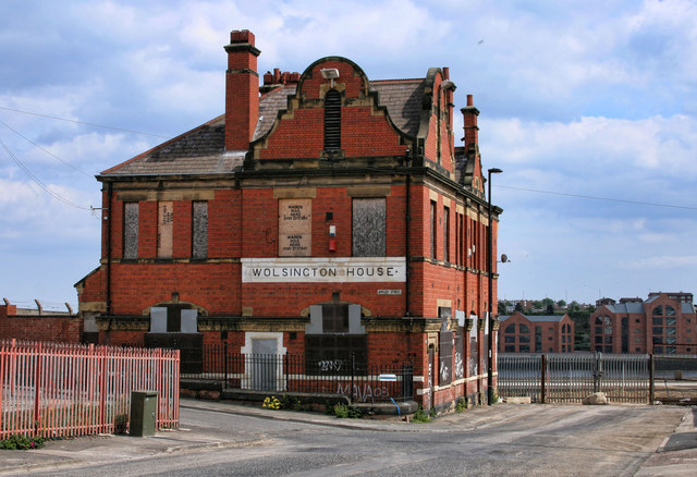
Wolsington House
- Overview Map Street View Wolsington House is a former public house on Burdon Main Row, by the Dock Road Industrial Estate, in North Shields. It is situated on an elavated …
Co-Curate Page
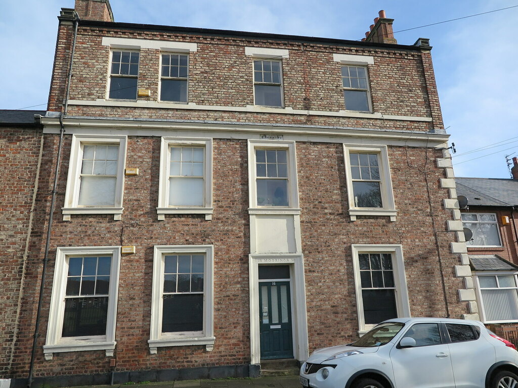
The Moorings, No.16, Brightman Road, North Shields
- Overview Map Street View The Moorings is a house on Brightman Road, North Shields. It was built in 1850 and was the home of Chevalier Henry Anson Brightman who lived …
Co-Curate Page
Smith's Dock Company War Memorial, West End Park, North Shields
- Overview Map Street View This war memorial is located off Minton Lane, in West End Park, near Riverside Primary School. The memorial was erected by the Smith's Dock Company in …
Co-Curate Page
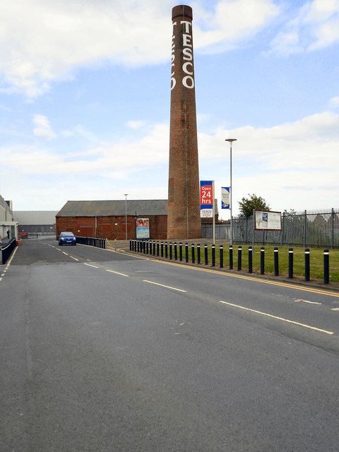
Tesco Chimney, West Chirton
- Overview Map Street View The 'Tesco Chimney' is located by the Tesco Extra store off Norham Road, on the West Chirton Industrial Estate, in North Shields. It is a surviving …
Co-Curate Page
Monkseaton Methodist Church
- Overview Map Street View Monkseaton Methodist Church is located on Front Street in Monkseaton. The building was originally a byre, stable and turnip house, forming part of Monkseaton Village Farm. …
Co-Curate Page
Friends Meeting House, Monkseaton
- Overview Map Street View This Friends Meeting House is located at No. 23, Front Street, in Monkseaton. The building was originally a single storey cottage (Gourd Cottage) associated with Monkseaton …
Co-Curate Page
Richardson Dees Park, Wallsend
- Overview Map Street View "In 1897, local solicitor and benefactor Robert Richardson Dees donated fourteen acres of his Hall estate to the Urban District Council for use as a park. …
Co-Curate Page
Killingworth Cottage
- Overview Map Street View Killingworth Cottage is a late 18th century house, located on West Lane in Killingworth Village. It is a Grade II listed building on the National Heritage …
Co-Curate Page
North Farm House, Killingworth Village
- Overview Map Street View North Farm House, now a house, is located on West Lane in Killingworth Village. The lintel above the door is inscribed 'DP 1725' with 'DP' being …
Co-Curate Page
Marden Bridge Middle School
- Overview Map Street View Marden Bridge Middle School is located on Lovaine Avenue in Whitley Bay. It is a community school with about 530 pupils aged 9 to 13.[1] The school …
Co-Curate Page
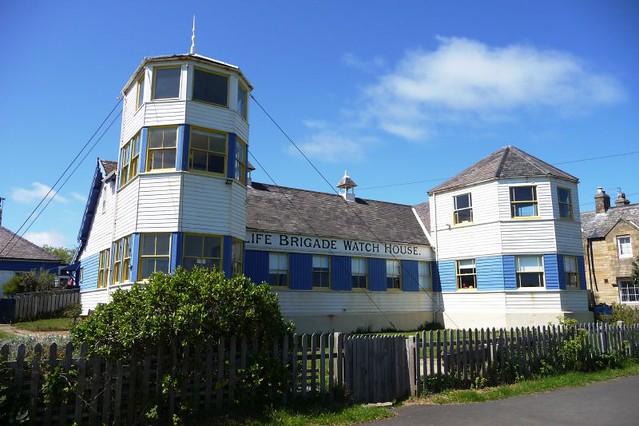
Watch House Museum
- Overview Map Street View The Tynemouth Volunteer Life Brigade, founded in 1864, was the first such organisation in the country. The Watch House was built 1886-1887 overlooking the Black Midden …
Co-Curate Page
Lily Bank Cottage, Wallsend
- Overview Map Street View Lily Bank Cottage, on Lily Bank in Wallsend dates from the early 19th century, with a later rear extension. The building is Grade II listed on …
Co-Curate Page
Lily Bank, Wallsend
- Overview Map Street View Lily Bank is a road in old Wallsend, which falls within The Green Connservation Area. Lily Bank Cottage dates for the early-19th century. The postbox on …
Co-Curate Page
Crane House, Duke Street
- Overview Map Street View Crane House Vaults is a former public house, now apartments, located on Duke Street in North Shields, opposite Ferry Mews. The building has an attractive glazed …
Co-Curate Page
Rake House Farm
- Overview Map Street View Rake House is a small-business and office complex, based on a former farm on Rake Lane in Preston Grange, North Shields. The former farmhouse dates from …
Co-Curate Page
Preston Colliery War Memorial
- There is a war memorial located in the south-west side of Preston Cemetery. The memorial was commissioned by the owners of Preston Colliery; G.A. Ritson and Sons. Of 900 men employed …

Co-Curate Page
South African War Memorial, Tynemouth
- Overview Map Street View The South African War Memorial is located at the west end of the public garden area by Front Street and Huntington Place, in Tynemouth. The red …

Co-Curate Page
Accumulator Tower, Albert Edward Dock
- Overview Map Street View The hydraulic accumulator tower is located in what today is the Royal Quays Marina in North Shields. The 2 story tower was built in 1882 for …
Co-Curate Page
Former British Gas Engineering Research Station
- Overview Map Street View This former British Gas Research Station is located off Station Road in Killigworth. It was originally built 1966-1967, designed by Ryder and Yates, and extended. It …
Co-Curate Page
Dial Cottage, West Moor near Killingworth
- Overview Map Street View The plaque above the door of Dial Cottage reads: "George Stephenson engineer. Inventor of the Locomotive Engine lived in this cottage from (1805 to 1823), his …
Co-Curate Page
Church of St George
- Overview About the Church Map Street View The Parish Church in Cullercoats was built between 1882 and 1884 by the Duke of Northumberland in memory of his father George Percy, …
Co-Curate Page
Tynemouth Station
- Overview About the Station History Map Street View Tynemouth Station opened on 7th July 1882. It was designed by William Bell for the North Eastern Railway Company (NER). It replaced …
Co-Curate Page
Beehive Inn, nr Earsdon
- Overview Map Street View The Beehive is a pub near Whitley Bay. It is located on Hartley Lane (the B1325) half a mile north east of Earsdon and 2.5 miles …
Co-Curate Page
Burradon Tower
- Overview About Burradon Tower Map Burradon Tower is a ruined Pele Tower (defensive tower) in Burradon, built during times of hostilities with Scotland. The Tower is a Grade II listed …
Co-Curate Page
Christ Church
- Overview About Christ Church Map Street View Christ Church, North Shields, Tyne and Wear, England is an Anglican church in the parish of North Shields Christ Church, diocese of …
Co-Curate Page
Church of St. Alban
- Overview Map Street View The Parish Church at Earsdon was built 1836-1837, on the site of a much earlier 13th century church. The church was designed by John & Benjamin Green, …
Co-Curate Page
Church of St Bartholomew
- Overview About the Church Map Street View St Bartholomew's Church is located off Station Road in Longbenton. The parish church is on a Medieval site dating back to at least …
Co-Curate Page
Church of St. Edward
- Overview Map Street View St Edward’s Roman Catholic Church on Coquet Avenue in Whitley Bay was built 1926-1928 to the designs of Stienlet & Maxwell of Newcastle. It was opened …
Co-Curate Page
Edward Eccles Church Hall
- Overview Map Street View The Hall, which belongs to St Alban's Church, is located at the west edge of Earsdon. Designed by Wilkinson and Crawley, it was built 1910-1911 and …
Co-Curate Page
Church of St Paul
- Overview Map Street View St Paul's Parish Church on Park View in Whitley Bay was built in 1864 by Salvin, and paid for by the Duke of Northumberland. The west …
Co-Curate Page
Clock Tower
- Overview Map Street View The distinctive clock tower and drinking fountain is located at the head of Front Street in Tynemouth, close to Tynemouth Priory. The Venetian Gothic style clock tower …
Co-Curate Page
Spanish City
- Overview About Map Street View In c.1904 Charles Elderton, of Hebburn Theatre Royal, started bringing the "Toreadors" concert party to perform at Whitley Bay. Following repeated success, he established a …
Co-Curate Page
Rendezvous Cafe
- Overview Map Street View The iconic Art Deco style cafe at Duke's Walk by the North Promenade was built in June 1930 by Whitley Bay & District Council, and originally …
Co-Curate Page
Coronation Fountain, North Promenade
- Plaque reads: "This drinking fountain was erected on 12th May 1937 to commemorate the coronation of T. M. King George and Queen Elizabeth". The fountain is Grade II listed as …
Co-Curate Page
Church of St Luke
- Overview Map Street View St Luke's Parish Church in Wallsend is located on the corner of Frank Street and Station Road. The church was built 1885-1887 by Oliver, Leeson and …
Co-Curate Page
Church of St Peter
- Overview Map Street View The Church of St. Peter in Wallsend was built in 1809 and extensively modified in 1892. The church is Grade II* listed on the National Heritage …
Co-Curate Page
Holy Cross Church (ruins)
- Overview Map Street View The Holy Cross Church, located near Valley Gardens in Wallsend dates from the mid 12th century. It was the chapel for Wallsend in the parish of …
Co-Curate Page
NEM Hammer-head Crane
- The giant 'NEM Hammerhead Crane' in Wallsend was built for the North Eastern Marine Engineering Company in 1909. At the time it was built, it was said to be the largest crane …
Co-Curate Page
Buddle Arts Centre
- Overview Map Street View Buddle Arts Centre is located on Station Road in Wallsend. The building was originally Buddle School or Wallsend Board Schools (for juniors and infants), completed in 1876 and …
Co-Curate Page
Coach & Horses
- Overview Map Street View The Coach and Horses in Wallsend is a public house located on the junction of High Street East and Coach Road. The pub was built c.1907 …
Co-Curate Page
Market Woman
- Sculpture of a Roman Woman by Hans Schwarz (1922-2003) in Wallsend. The sculpture was commissioned by J Seymour Harris and Partners, developers of the Forum shopping centre, and was unveiled …
Co-Curate Page
Town Hall
- Overview Map Street View The Town Hall, now a Business and a Conference Centre, were built 1907-8 by E.F.W. Liddle and P.L. Brown for the Borough of Wallsend. The Town …
Co-Curate Page
Old Wallsend Library, Ferndale Avenue
- Overview Map Street View The former Library on Ferndale Avenue in Wallsend was built 1965-1966, designed by Harry Faulkner Brown. The library closed on the 15th February 2014, and was …
Co-Curate Page
War Memorial
- The War Memorial for the Borough of Wallsend is located off Archer Street. It is a tall granite obelisk topped with a bronze angel of victory. The panel on the …
Co-Curate Page
Willington Dene Viaduct
- Overview Map Street View Willington Dene Viaduct is a railway bridge over the valley of Wallsend Burn near Willington and Wallsend. It was built between 1837-1839 by John and Benjamin Green …
Co-Curate Page
Segedunum
- Overview About Segedunum Map Segedunum was a Roman fort built at the eastern end of Hadrian's Wall near the banks of the River Tyne. It is located in modern-day Wallsend, …
Co-Curate Page
Cullercoats Lifeboat Station
- Overview Map Street View The first lifeboat in Cullercoats was funded by the Duke of Northumberland. This became operational in 1852 following the establishment of The Royal National Lifeboat Institution (RNLI) …
Co-Curate Page
Cullercoats Metro Station
- Overview About Map Street View The Metro station at Cullercoats was originally a railway station, which opened on the 7th July 1882. The station was built by the North Eastern …
Co-Curate Page
Dove Marine Laboratory
- Overview About Map Street View The first laboratory at Cullercoats was constructed by the Northumberland Sea Fisheries Committee and opened on the 21st of October 1897.[1] It was a small wooden …
Co-Curate Page
Church of the Holy Saviour
- Overview Map Street View Holy Saviour's Church on The Broadway/Crossway in Tynemouth was built 1839 to 1841 by John Green and Benjamin Green for the Duke of Northumberland. The parish …
Co-Curate Page
Collingwood Monument
- Overview About the Monument Map Street View The Collingwood Monument was built in 1845 in honour of Admiral Lord Collingwood, who led the British Fleet to victory at the Battle …
Co-Curate Page
Land of Green Ginger
- Overview Map Street View The former Congregational Church on Front Street in Tynemouth was built in 1868 by Thomas Oliver. The adjoining Church Hall was built in 1886.[1] In the …
Co-Curate Page
Statue of Queen Victoria
- Overview Map Street View The bronze memorial statue of Queen Victoria on Front Street in Tynemouth was by Alfred Turner and built in 1902. It was paid for by public …
Co-Curate Page
War Memorial
- Overview Map Street View The First World War Memorial in Tynemouth is located in the centre of the park by Front Street, between the Statue of Queen Victoria and the …
Co-Curate Page
Tynemouth Priory and Castle
- Overview History Aerial View Street View Tynemouth Castle is located on a rocky headland (known as Pen Bal Crag) at Tynemouth, overlooking Tynemouth Pier and the mouth of the River …
Co-Curate Page
Tynemouth Pier and Lighthouse
- Overview Map Street View Work on the North Pier in Tynemouth began in 1854 and on the South Pier (in South Shields) in 1856. Both piers were originally constructed in …
Co-Curate Page
Grand Hotel
- Overview Map Street View The Grand Hotel is located on Grand Parade, by the sea front at Tynemouth. It was originally built in 1872 as seaside house for Duchess of …
Co-Curate Page
Tynemouth Outdoor Swimming Pool
- Overview Map Street View "Tynemouth outdoor swimming pool was first opened on 30th May 1925 and was once one of the area’s favourite and most prestigious attractions. It was automatically …
Co-Curate Page
Tynemouth Lodge Hotel
- Overview Map Street View Inside The Tynemouth Lodge Hotel is a traditional pub on Tynemouth Road in North Shields (non residential), located by Northumberland Park, close to Tynemouth. "This building …
Co-Curate Page
Clock on Buddle Street
- Overview Map Street View This Gothic-style cast iron clock is by the junction of Buddle Street and Station Road, near Segedunum in Wallsend. It was built in the late 19th …
Co-Curate Page
The Ritz, Wallsend
- Overview Map Street View The Ritz is a public house on High Street West in Wallsend. It was originally the Ritz Cinema, which opened on the 15th of May 1939 …
Co-Curate Page
Rising Sun Inn
- Overview Map Street View The Rising Sun is a public house by the Coast Road in Wallsend. It was built in the 1930's to serve the new community in the …
Co-Curate Page
Public Baths, Wallsend
- Overview Map Street View The former public baths in Wallsend are located on Lawson Street, behind the Town Hall. The 'Restrained Baroque' style building was built by E.F.W Liddle and …
Co-Curate Page
Look-out Post & Gun Emplacement, Percy Gardens
- Overview Map Street View 47A Percy Gardens (west side) in Tynemouth is a former lookout post and gun emplacement built in c.1916, during the First World War. It is a …
Co-Curate Page
Bay View House (former Rex Hotel)
- Overview Map Street View Bay View House is located on the corner of Promenade and South Parade in Whitley Bay. This is the former 70 bedroom Rex Hotel, which closed in 2016. …
Co-Curate Page
Drinking Fountain, St Paul's Church
- The old drinking fountain, dated 1864, is built into the boundary wall of St Paul's Church in Whitey Bay. It is Grade II listed on the National Heritage List for …
Co-Curate Page
N.E. Co-op, John Street
- Overview Map Street View "This building was opened in 1895 by the North Shields Co-operative Society, subsequently North Eastern Co-operative Society. It is still in use by the Co-op. The building …
Co-Curate Page
The Ritz, Forest Hall
- Overview Map Street View The 'Ritz' Bingo & Social Club in Forest Hall was originally a cinema. The Ritz cinema, with 1,062 seats, opened on the 9th November 1936 with …
Co-Curate Page
New York War Memorial
- Overview Map Street View The war memorial on Murton Lane in New York in inscribed with the names of 68 local servicemen from the district who lost their lives in the …
Co-Curate Page
War Memorial
- Overview Map Street View The Cenotaph in Whitley Bay is located on the Links, by the Empress Gardens, close to Spanish City. The memorial was officially unveiled on the 15th …
Co-Curate Page
Sir James Knott Memorial Flats
- Overview Map Street View The Sir James Knott Memorial Flats on Tynemouth Road, overlooking the mouth of the Tyne, in North Shields and close to Tynemouth, were opened in 1939. …
Co-Curate Page
Old Tynemouth Station
- Overview Map Street View The first railway station in Tynemouth was opened on the 20th of March 1847 by the Newcastle and Berwick Railway. The station buildings were designed by …
Co-Curate Page
Cumberland Arms, Tynemouth
- Overview Map Street View The Cumberland Arms is located at 17 Front Street, Tynemouth. It is a red brick and faience Victorian gothic-style public house, which was built in 1898 …
Co-Curate Page
Monkseaton Station
- Overview About Map Street View The railway station at Monkseaton opened 25th July 1915, replacing the former Whitley Junction station of 1860, which was located in what is now Souter Park. …
Co-Curate Page
Grants Clock
- Overview Map Street View There is a clock with 2 faces located on the Promenade in Whitley Bay, close to the junction with South Parade. The clock stands on a …
Co-Curate Page
Northumberland Square
- Overview Map Street View Northumberland Square was the centrepiece of the 'New Town' development of North Shields built in the late 18th and early 19th century.
Co-Curate Page
Wallsend Hall
- Overview Memorial Hospital Map Street View Wallsend Hall is located on The Green in Wallsend. The house was built in the early 19th century and had significant grounds. The Hall …
Co-Curate Page
Church of St John the Evangelist
- Overview Map Street View The Church of St John the Evangelist is located on West Lane in Killingworth Village. Killingworth had been part of the parish of Longbenton, but became …
Co-Curate Page
Killingworth Hippopotami
- Overview Map Concrete Hippos by Stan Bonnar (b.1948), located at Garth 22, Killingworth. The sculpture is on the Register of Buildings and Parks of Local Architectural and Historic Interest ('Local List') …
Co-Curate Page
Old Fire Station, Wallsend
- Overview Map Street View The old Fire Station is located on Lawson Street in Wallsend. It was built in c.1908 by E.F.W. Liddle and P.L. Brown for the Borough of Wallsend. …
Co-Curate Page
Church of St Mary The Virgin, Willington
- Overview Map Street View The Church of St Mary the Virgin is located on Churchill Street in Willington was built in 1876 by Austin and Johnson. The parish church is …
Co-Curate Page
Willington Mill
- Overview Map Street View Willington Mill is situated by Willington Gut and located on Gut Road, off Ropery Lane. Constructed around 1805, this is a four-storey brick-built corn mill with …
Co-Curate Page
War Memorial, Shiremoor
- Overview Map Street View The War Memorial in Shiremoor is located off Emmerson Place. The memorial is a statue of a Northumberland Fusilier resting on reversed rifle, on tall column.[1] …
Co-Curate Page
Old Signpost, Shiremoor
- This "finger post" at the junction of Park Lane and Earsdon Road, in Shiremoor, dates from the later C19 or early C20. It was manufactured by the firm of Smith, …
Co-Curate Page
The Ship Inn, Benton
- Overview Map Street View Inside The Ship Inn on Front Street in Benton dates from 1904. The Ship Inn is listed on North Tyneside Council's register of buildings and parks …
Co-Curate Page
North House, Benton
- Overview Map Street View North House is located on Front Street in Benton, within the Longbenton Conservation Area, and believed to be the site of a vicarage since 1343. The …
Co-Curate Page
Church of St Augustin
- Overview Map Street View St Augustin's Church is located by the junction of Jackson Street and Washington Terrace in North Shields. It was designed as a replica of St Andrew’s …
Co-Curate Page
Church of St. Columba, North Shields
- Overview Map Street View St Columba's United Reformed Church is located on Northumberland Square (no. 30) in North Shields. It was originally built as a Presbyterian Church, designed in an …
Co-Curate Page
Mechanics Institute and Free Library
- Overview Map Street View The former Free Library is located on Howard Street by the junction with Saville Street, North Shields. The Mechanics Institute was built 1857-1858, designed by John …
Co-Curate Page
Low Lights Tavern, North Shields
- Overview Map Street View Low Lights Tavern is located on Brewhouse Bank, North Shields. It was originally built as a house in the late 18th Century, and later converted for …
Co-Curate Page
Hodgson Tomb, Christ Church, North Shields
- Overview Map Street View This old sandstone chest tomb of c.1690 is located in the churchyard of Christ Church, by Preston Road in North Shields. This is the tomb of …
Co-Curate Page
Panama Gardens
- Overview Map Street View In October 1932 Whitley & Monkseaton Urban District Council discussed a scheme for sunken gardens on The Links between Watts Road and Panama House (a cafe …
Co-Curate Page
House of Correction
- The former Tynemouth House of Correction and Justice Room on Tynemouth Road in North Shields was built in 1792. It was converted into a workshop in 1906 and significantly altered …
Co-Curate Page
Salvation Army Citadel
- Overview Map Street View The Salvation Army Citadel is located at no. 28 Howard Street, North Shields. It was originally built in 1811 as Scotch Church, designed by John Dobson. The …
Co-Curate Page
Kiki's Kabin (former church)
- Overview Map Street View Kiki's Kabin is located on Albion Road, North Shields. This children's play centre is a former non-conformist church. The Church, Sunday School and minister's house was …
Co-Curate Page
Irvin's Building
- Overview Map Street View The Irvin Building is located on Union Road on the North Shields Fish Quay. It was built in 1913 for Richard Irvin and Sons Ltd., who …
Co-Curate Page
Old Low Light
- Overview Map Street View The Old Low Light is a heritage centre and cafe located at the Fish Quay in North Shields. It was originally built as a lighthouse in …
Co-Curate Page
Rose Inn, Rosehill Bank
- Overview Map Street View The Rose Inn is a public house located on Rosehill Bank in the Rosehill area of Wallsend. The ornate terracotta two storey public house opened in …
Co-Curate Page
Low Light
- Overview Map Street View The "New" Low Light on North Shields Fish Quay was built 1805-1808 by Trinity House and first lit in 1810.[1]. In conjunction with the High Light in …
Co-Curate Page
High Light
- Overview Map Street View The "New" High Light, on Tyne Street, North Shields was built in 1807, designed by John Stokoe for Trinity House, and first lit in 1810.[1] In conjunction with the Low Light on the North Shields Fish Quay, …
Co-Curate Page
Ballards Smoke House, Fish Quay
- Overview Map Street View Ballards Smoke House is located in the Fish Quay area of North Shields. At first glance it looks like a modern building with its distinctive contemporary …
Co-Curate Page
Low Dock, Liddell Street, North Shields
- Overview Map Street View Low Dock, off Liddell Street in North Shields dates from the early 19th century. It is the oldest surviving graving dock on Tyneside. Low Dock is …
Co-Curate Page
Ethel Williams Hall, Front Street
- Overview Map Street View Ethel Williams Hall is located on Front Street in Benton. The house was built in c.1734 for C. Hayton. The building was used as a vicarage …
Co-Curate Page
Jasmine House, The Green, Wallsend
- Overview Map Street View Jasmine House is located on The Green, by the junction with Crow Bank, in Wallsend. It dates from the mid to late 18th century and is …
Co-Curate Page
Cross House, The Green, Wallsend
- Overview Map Street View Cross House is located on The Green in Wallsend. Dame Eleanor Allan (founder of Dame Allan's school in Newcastle) taught for short period in the house. …
Co-Curate Page
Wallsend Health Centre, The Green, Wallsend
- Overview Map Street View The Village Green Surgery (aka Wallsend Health Centre) is located next to Wallsend Hall, on The Green in Wallsend. Pre-dating the creation of the National Health …
Co-Curate Page
Richardson Dees Primary School
- Overview Map Street View Richardson Dees Primary School is located on High Street East in Wallsend. It is a Foundation school, under North Tyneside Learning Trust. The school has about …
Co-Curate Page
Former Queen Alexandra College Building, Hawkeys Lane
- This building on Hawkeys Lane in North Shields is part of the former site of Queen Alexandra Sixth Form College. It was originally built in 1909 for the Tynemouth Education …
Co-Curate Page
St. Leonard's Hospital
- Overview Map St. Leonard’s Hospital was built during the 13th Century and the earliest documentary evidence is an assize roll of 1293 which mentions “the bridge of the hospital of …
Co-Curate Page
War Memorial, Hawkeys Lane
- Overview Map Street View This war memorial stands outside the Health Centre on Hawkeys Lane in North Shields. The memorial, dedicated those lost in the First World War, was uveiled …
Co-Curate Page
Victoria Jubilee Infirmary, Hawkeys Lane
- Overview Map Street View The former Victoria Jubilee Infirmary is located on Hawkeys Lane in North Shields. The outpatient wing was built in 1932, designed by Cackett, Burns, Dick & …
Co-Curate Page
Wolsington House
- Overview Map Street View Wolsington House is a former public house on Burdon Main Row, by the Dock Road Industrial Estate, in North Shields. It is situated on an elavated …
Co-Curate Page
The Moorings, No.16, Brightman Road, North Shields
- Overview Map Street View The Moorings is a house on Brightman Road, North Shields. It was built in 1850 and was the home of Chevalier Henry Anson Brightman who lived …
Co-Curate Page
Smith's Dock Company War Memorial, West End Park, North Shields
- Overview Map Street View This war memorial is located off Minton Lane, in West End Park, near Riverside Primary School. The memorial was erected by the Smith's Dock Company in …
Co-Curate Page
Tesco Chimney, West Chirton
- Overview Map Street View The 'Tesco Chimney' is located by the Tesco Extra store off Norham Road, on the West Chirton Industrial Estate, in North Shields. It is a surviving …
Co-Curate Page
Monkseaton Methodist Church
- Overview Map Street View Monkseaton Methodist Church is located on Front Street in Monkseaton. The building was originally a byre, stable and turnip house, forming part of Monkseaton Village Farm. …
Co-Curate Page
Friends Meeting House, Monkseaton
- Overview Map Street View This Friends Meeting House is located at No. 23, Front Street, in Monkseaton. The building was originally a single storey cottage (Gourd Cottage) associated with Monkseaton …
Co-Curate Page
Richardson Dees Park, Wallsend
- Overview Map Street View "In 1897, local solicitor and benefactor Robert Richardson Dees donated fourteen acres of his Hall estate to the Urban District Council for use as a park. …
Co-Curate Page
Killingworth Cottage
- Overview Map Street View Killingworth Cottage is a late 18th century house, located on West Lane in Killingworth Village. It is a Grade II listed building on the National Heritage …
Co-Curate Page
North Farm House, Killingworth Village
- Overview Map Street View North Farm House, now a house, is located on West Lane in Killingworth Village. The lintel above the door is inscribed 'DP 1725' with 'DP' being …
Co-Curate Page
Marden Bridge Middle School
- Overview Map Street View Marden Bridge Middle School is located on Lovaine Avenue in Whitley Bay. It is a community school with about 530 pupils aged 9 to 13.[1] The school …
Co-Curate Page
Watch House Museum
- Overview Map Street View The Tynemouth Volunteer Life Brigade, founded in 1864, was the first such organisation in the country. The Watch House was built 1886-1887 overlooking the Black Midden …
Co-Curate Page
Lily Bank Cottage, Wallsend
- Overview Map Street View Lily Bank Cottage, on Lily Bank in Wallsend dates from the early 19th century, with a later rear extension. The building is Grade II listed on …
Co-Curate Page
Lily Bank, Wallsend
- Overview Map Street View Lily Bank is a road in old Wallsend, which falls within The Green Connservation Area. Lily Bank Cottage dates for the early-19th century. The postbox on …
Co-Curate Page
Crane House, Duke Street
- Overview Map Street View Crane House Vaults is a former public house, now apartments, located on Duke Street in North Shields, opposite Ferry Mews. The building has an attractive glazed …
Co-Curate Page
Rake House Farm
- Overview Map Street View Rake House is a small-business and office complex, based on a former farm on Rake Lane in Preston Grange, North Shields. The former farmhouse dates from …
Co-Curate Page
Preston Colliery War Memorial
- There is a war memorial located in the south-west side of Preston Cemetery. The memorial was commissioned by the owners of Preston Colliery; G.A. Ritson and Sons. Of 900 men employed …


