Topics > Heritage Sites > Listed Buildings > Local List
Local List
Many local authorities maintain heritage "Local Lists" (Non-Designated Heritage Assets), usually developed with public consultation as part of the Neighbourhood Plan. The local list includes buildings, structures, parks and gardens which have special local architectural, heritage or historic interest. This differs from the National Heritage List for England (NHLE), which includes building recognised as being of national importance. Whilst buildings and parks on the Local List may not be recognised as being of particular national relevance, they are of special importance to the locality. They do not have the legal protection and restrictions of those on the NHLE. However, many are located within Conservation Areas, which do have some restrictions.

Co-Curate Page
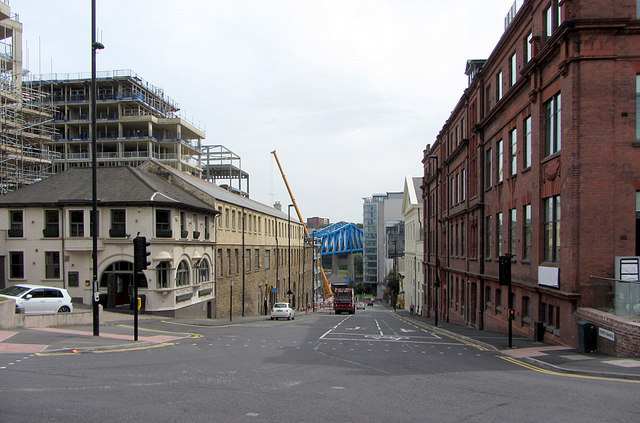
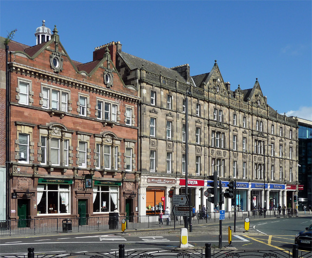
No. 20 Collingwood Street
- Built in 1889 by R K Freeman and Robins for Mr Swanson. The building is on the Local List.

Co-Curate Page
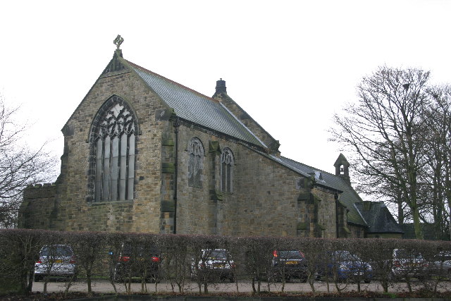
Church of St. Joseph
- St Joesph's Church in Benwell is located at the junction of Armstrong Road and South Benwell Road. The neo-Byzantine style building was designed by Stienlet & Maxwell and opened in October …

Co-Curate Page
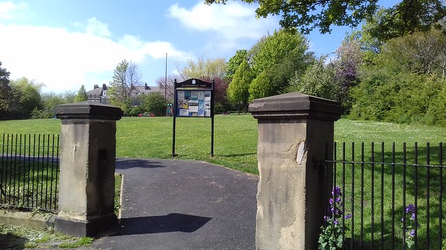
Benwell Nature Park
- Overview About Map Street View Benwell Nature Park was established in 1982 on land cleared by the demolition of two streets of terraced housing and a section of Atkinson Road in …

Co-Curate Page
Monkseaton Station
- Overview About Map Street View The railway station at Monkseaton opened 25th July 1915, replacing the former Whitley Junction station of 1860, which was located in what is now Souter Park. …

Co-Curate Page
Cullercoats Metro Station
- Overview About Map Street View The Metro station at Cullercoats was originally a railway station, which opened on the 7th July 1882. The station was built by the North Eastern …
Co-Curate Page
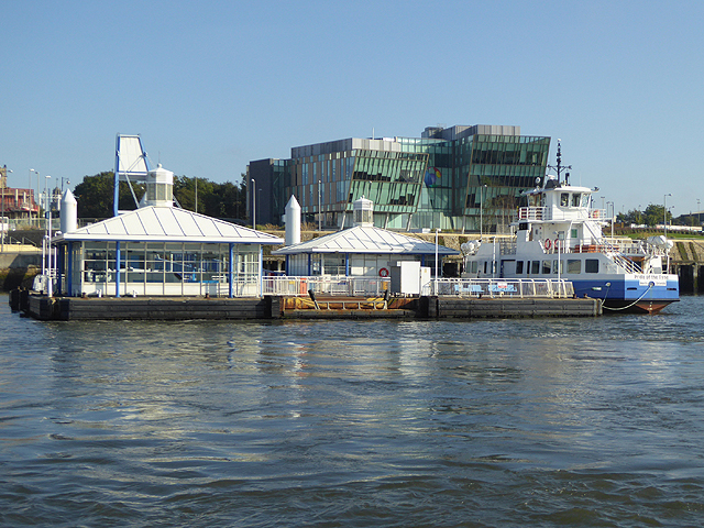
South Shields, Ferry Landing
- Overview Map Street View The new landing for the Shields Ferry in South Shields was built by Harbour & General at the Pallion Yard in Sunderland. The landing is made of …
Co-Curate Page
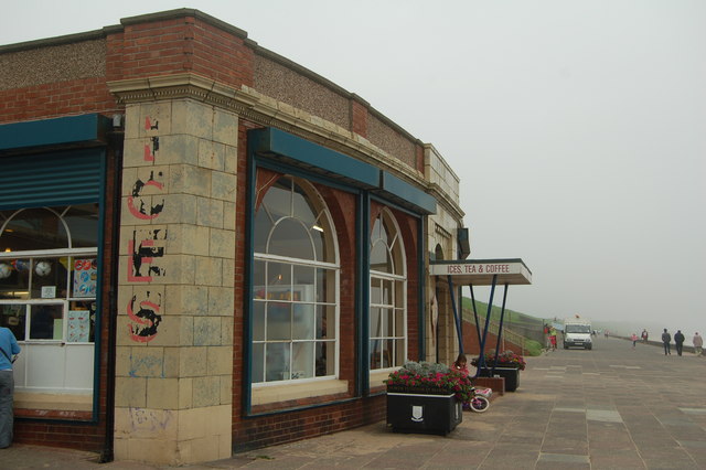
Rendezvous Cafe
- Overview Map Street View The iconic Art Deco style cafe at Duke's Walk by the North Promenade was built in June 1930 by Whitley Bay & District Council, and originally …
Co-Curate Page
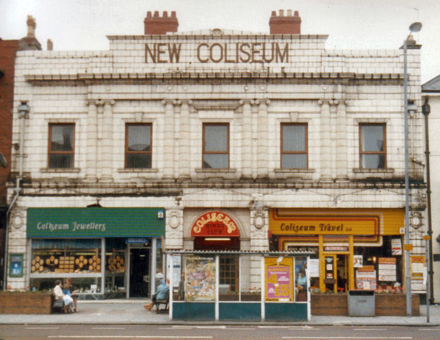
New Coliseum
- Overview Map Street View Former theatre and cinema at no's 246-248 Whitley Road. The grand façade of the New Coliseum is a feature of the town centre in Whitley Bay. …
Co-Curate Page
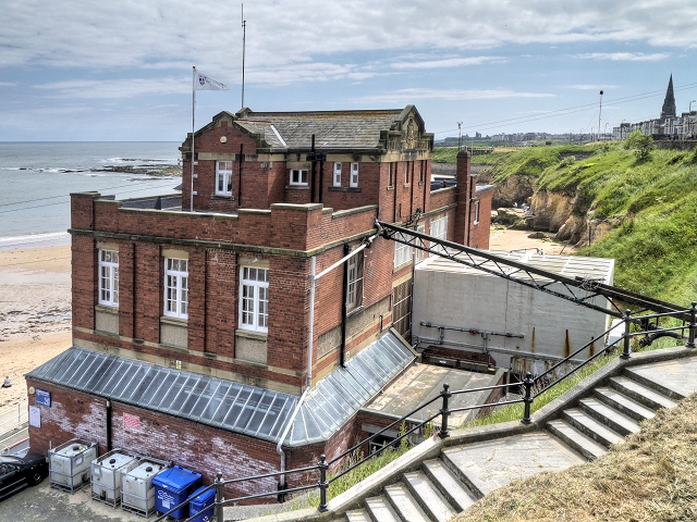
Dove Marine Laboratory
- Overview About Map Street View The first laboratory at Cullercoats was constructed by the Northumberland Sea Fisheries Committee and opened on the 21st of October 1897.[1] It was a small wooden …

from https://sitelines.newcastle.g…
Tyne and Wear HER(7423): Chopwell, Church of St. John the Evangelist
- "This beautifully finished and well-kept turn of the 20th century rural church is in snecked, tooled, golden sandstone with ashlar details. Below the small bell turret the stonework advances, giving …
Added by
Simon Cotterill
Co-Curate Page
Church of St. John the Evangelist, Chopwell
- Overview Map Street View The Church of St. John the Evangelist in Chopwell opened in 1909. It replaced an existing smaller church, as the parish population had expanded rapidy with …
Co-Curate Page
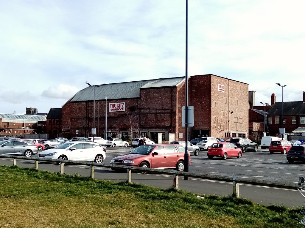
The Ritz, Forest Hall
- Overview Map Street View The 'Ritz' Bingo & Social Club in Forest Hall was originally a cinema. The Ritz cinema, with 1,062 seats, opened on the 9th November 1936 with …
Co-Curate Page
Church of St Anne
- Overview Map Street View St Anne's Church in Winlaton was built in 1962 and is part of the Roman Catholic diocese of Hexham and Newcastle.
Co-Curate Page
Path Head Water Mill, Blaydon
- Overview Map Street View The 18th Century Water Mill at Path Head, on Summerhill near Blaydon. The mill was derelict by 1974, but has been restored and renovated by the Vale …
Co-Curate Page
Cragside Primary School, High Heaton
- Overview Map Street View High Heaton Infants School ('the wooden school') opened on the 20th of August 1929 with a roll of 164 students. With a growing population in High …
Co-Curate Page
Northumberland Village Homes
- Overview Map Street View Village Court is tucked away off Norham Road by Monkseaton Metro Station. It has an interesting history... Northumberland Village Homes in Whitley Bay were built in …
Co-Curate Page
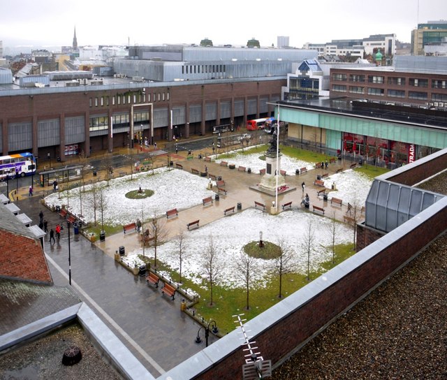
Old Eldon Square
- Overview About Old Eldon Square Map Street View Old Eldon Square off Blackett Street was built 1825 - 1831 as part of the mid 19th century redevelopment of Newcastle city centre. …
Co-Curate Page
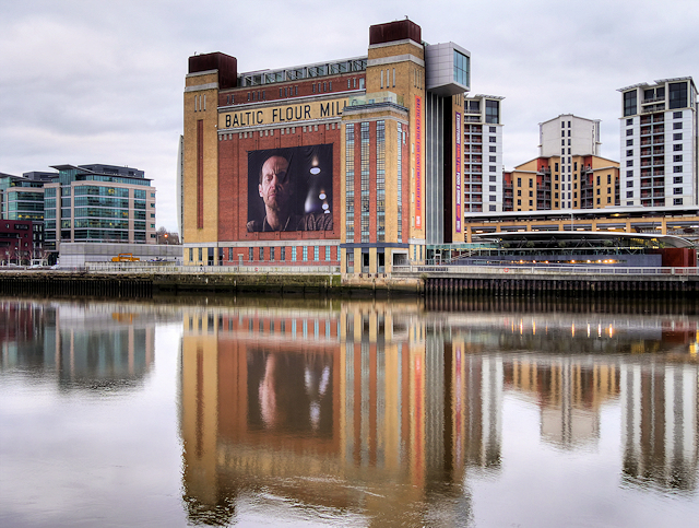
Baltic Centre for Contemporary Art
- Overview About the Baltic Map Street View The original Baltic Flour Mills were opened in 1950, built for the Rank Hovis company based on a 1930s design by Gelder and …
Co-Curate Page
Marsden Grotto
- Summary About Marsden Grotto Map Street View Marsden Grotto is a 'cave bar' pub and restaurant on the coast at South Shields. It's history can be traced back to 1782 …
Co-Curate Page
Whitburn Methodist Church
- Overview Map Street View Whitburn Methodist Church is located on North Guards in Whitburn. It was built in 1881 to replace an earlier Wesleyan Chapel of 1812.[1] A tapered octagonal tower …
Co-Curate Page
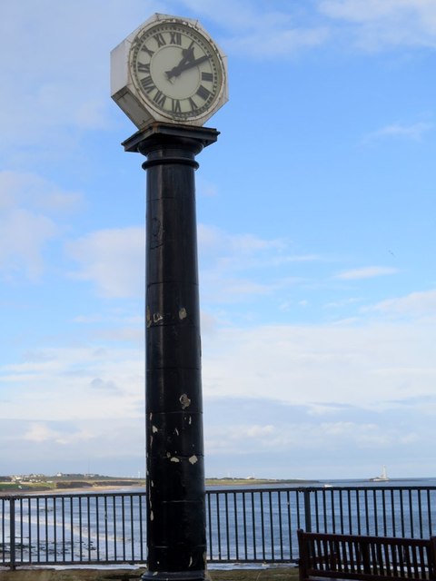
Grants Clock
- Overview Map Street View There is a clock with 2 faces located on the Promenade in Whitley Bay, close to the junction with South Parade. The clock stands on a …
Co-Curate Page
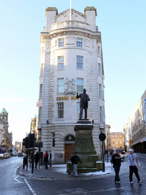
Cross House
- Overview Map Street View Cross House is a distinctive office building on the corner of Westgate Road and Fenkle Steet in Newcastle. It was designed by Cackett and Burns Dick architects …
Co-Curate Page
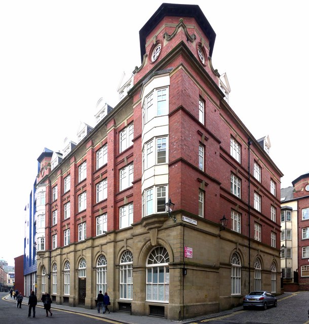
Old Cooperative Warehouse, Stowell Street
- Overview Map Street View 14-18 Stowell Street is the former warehouse of the Co-operative Wholesale Society, built in 1908. The warehouse was used for ripening fruit and had loading bays …
Co-Curate Page
Stage Door Nightclub, Stowell Street
- Overview Map Street View Now 'The Cosmic Ballroom' nightclub. The building at 20-22 Stowell Street was originally a warehouse, and was converted into a casino known as 'The Bird Cage' …
Co-Curate Page
Nos. 34-46 Stowell Street
- Overview Map Street View Nos. 34-46 are the only remaining original buildings from when Stowell Street was first built c.1824.[1] The buildings now house a number of restaurants.
Co-Curate Page
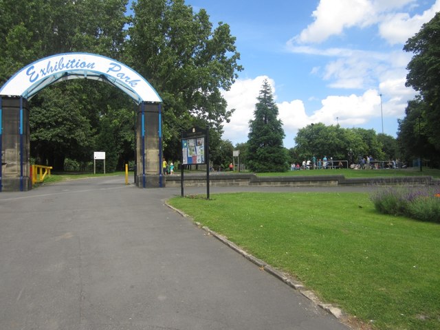
Exhibition Park
- Overview About Exhibition Park Map Street View Exhibition Park is a short walk from Newcastle City Centre; the main entrance is off Claremont Road. It became known as Exhibition Park …
Co-Curate Page
Byker Bridge
- Overview About Byker Bridge Map Street View The Byker Bridge is a 344.65m (1130 ft) long road bridge that carries the A193 road over the River Ouseburn in Newcastle …
Co-Curate Page
The Mansion House, Fernwood Road
- Overview Map Street View The Mansion House on Fernwood Road in Jesmond is the official residence of the Lord Mayor of Newcastle. It was originally built in 1880 as two …
Co-Curate Page
Quadrangle
- Overview Map Street View The Quadrangle lies at the heart of Newcastle University with gardens and thoroughfare, which is a favourite place for graduation photographs. It is surrounded on all sides, …
Co-Curate Page
People's Theatre
- Overview About the Prople's Theatre Map Street View 1959: "The unfailing support of the Tyneside audience for our choice of play encourages us to purchase the Lyric Cinema, Heaton. It …
Co-Curate Page
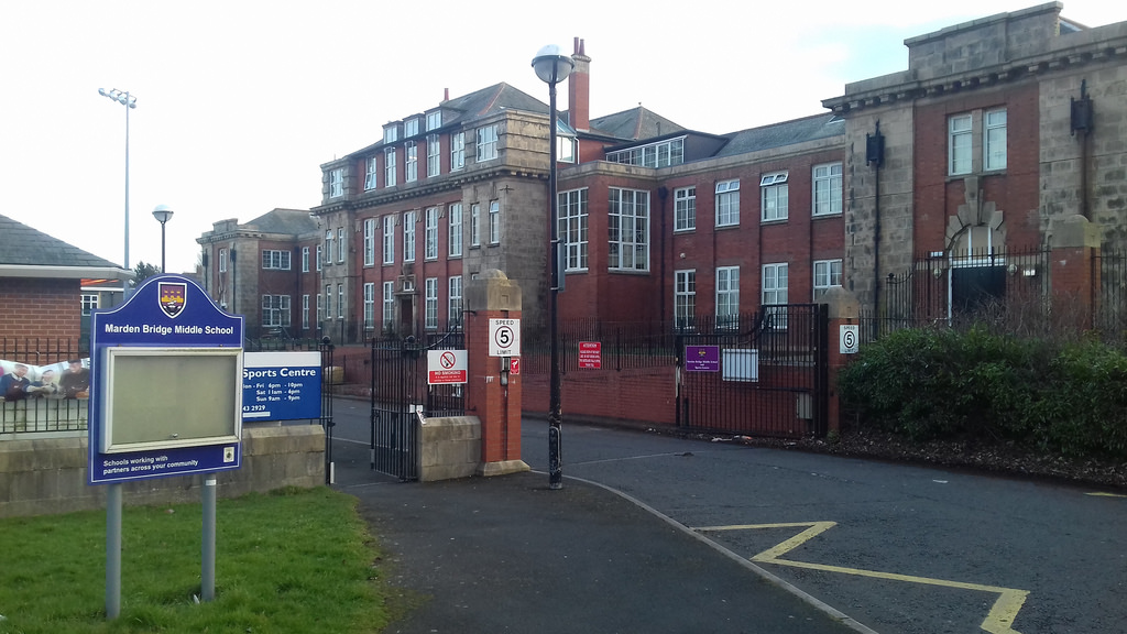
Marden Bridge Middle School
- Overview Map Street View Marden Bridge Middle School is located on Lovaine Avenue in Whitley Bay. It is a community school with about 530 pupils aged 9 to 13.[1] The school …
Co-Curate Page
Ravenswood Primary School
- Overview Map Street View Located on Ravenswood Road in Heaton, Ravenswood is one of the largest primary schools in Newcastle. It is a foundation school with about 650 pupils aged …
Co-Curate Page
Danby House and Blacksmith’s Forge
- Overview Map Street View Danby House at 321 Acklam Road, is a former small holding and part of the former village of Acklam, before it became part of Middlesbrough. It …
Co-Curate Page
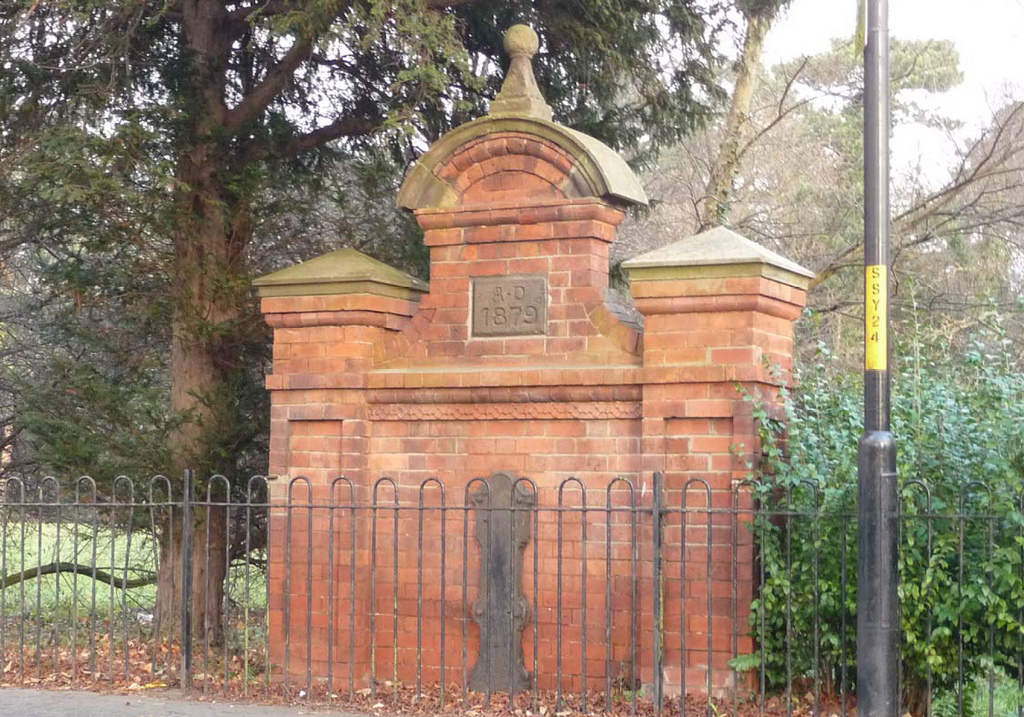
Drinking Fountain, Stokesley Road, Marton
- Overview Map Street View Dated 1879 and located on Stokesley Road, opposite St Cuthbert’s Church, and at the south-west corner of Stewart Park in Marton. The drinking fountain was built …
Co-Curate Page
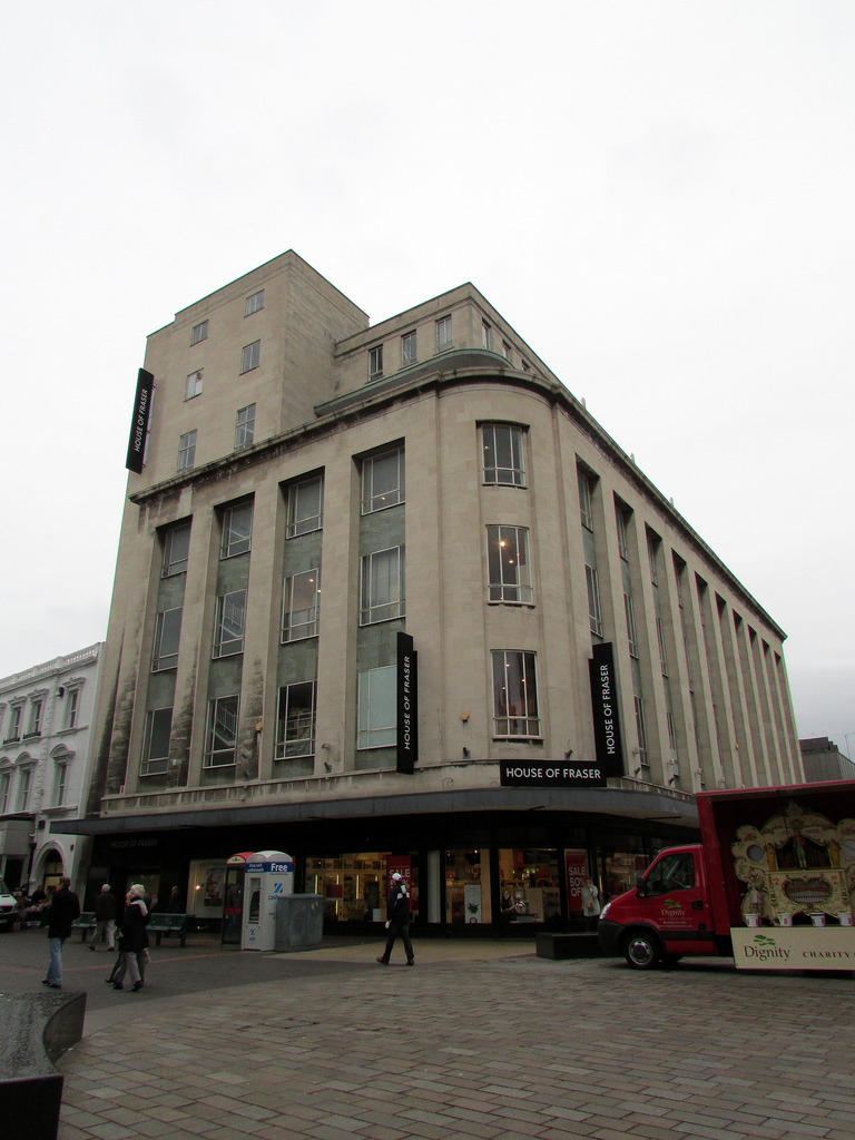
House of Fraser, 37 Linthorpe Road
- Overview Map Street View The House of Fraser Department Store (37 Linthorpe Road) is located in Middlesbrough town centre on the corner of Newport Road and Linthorpe Road. Built in …
Co-Curate Page
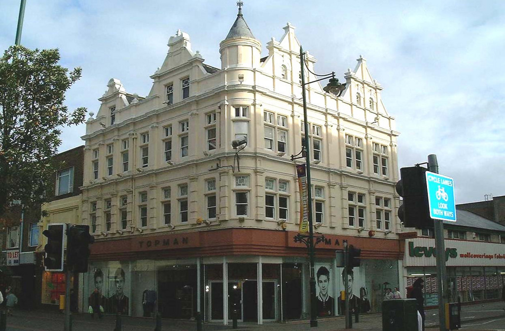
Miss Selfridge, 64-66 Linthorpe Road
- Overview Map Street View Nos. 64-66 Linthorpe Road in Middlesbrough is a Miss Selfridge store on the corner of Linthorpe Road and Corporation Road. The building was originally built in …
Co-Curate Page
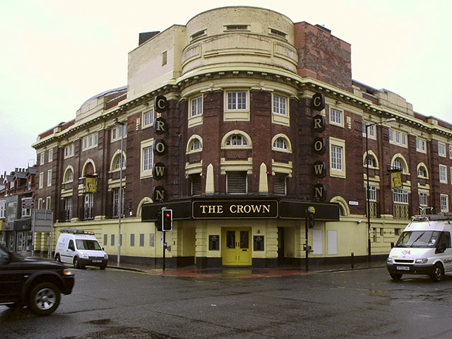
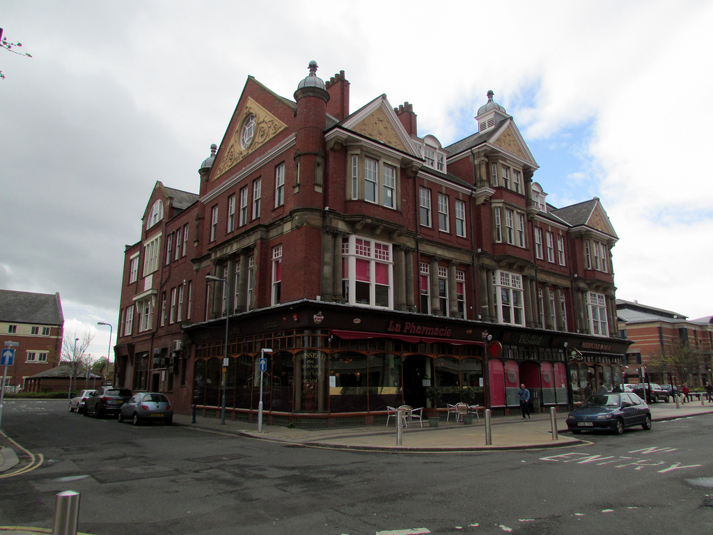
The Crown
- Overview Map Street View The Crown is a prominent building on the corner of Linthorpe Road and Borough Road, Middlesbrough. The building was designed by architect James Forbes, and was …
Co-Curate Page
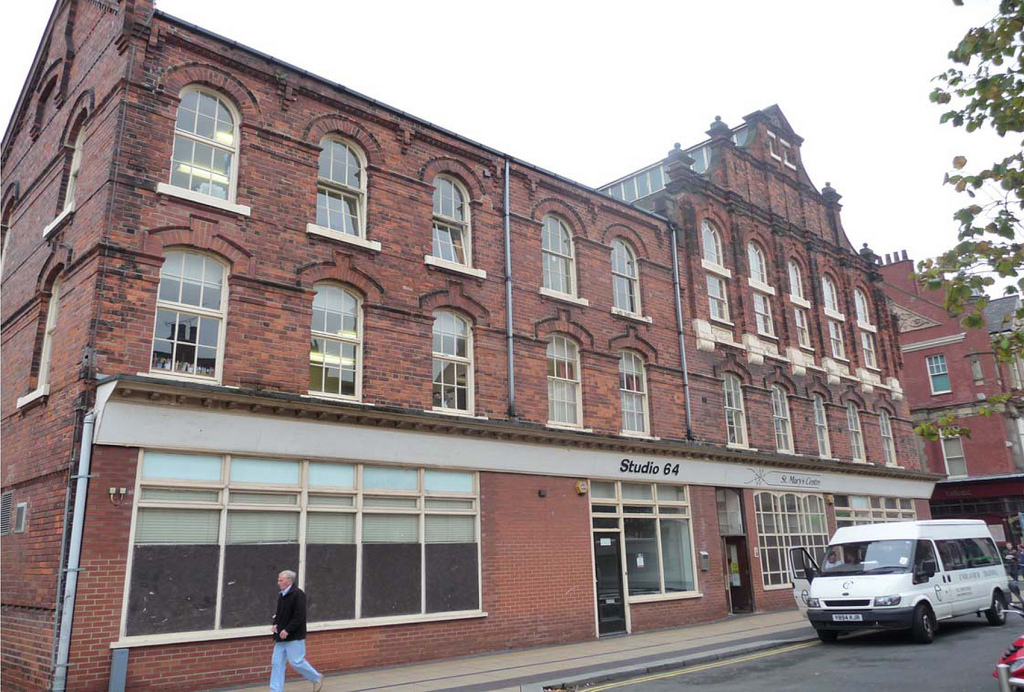
Methodist Church, 126-132 Linthorpe Road
- Overview Map Street View Built as a Methodist Church and Sunday School in 1892, located on the corner of Linthorpe Road and Borough Road in Middlesbrough. Today the church still …
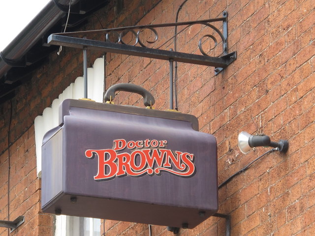
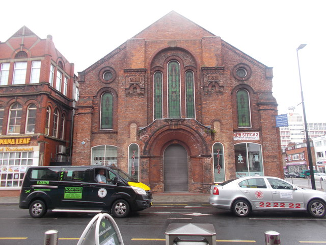
Co-Curate Page
Dr Brown's, Corporation Road
- Overview Map Street View Doctor Brown's pub is located on the junction of Corporation Road and Marton Road in the centre of Middlesbrough. The triangular building was originally built as …
Co-Curate Page
72-80 Corporation Road
- Overview Map Street View 72-80 Corporation Road, Middlesbrough was originally built in c.1898 as a shop, warehouse and offices for the Middlesbrough Co-operative Society. During the 1940’s and 1950’s the building …
Co-Curate Page
82-90 Corporation Road
- Overview Map Street View 82-90 Corporation Road in Middlesbrough was built in 1881. It was designed by William Duncan and Roger Lofthouse for the Middlesbrough Co-operative Society Branch, to house …
Co-Curate Page
Hawthorne House
- Overview Map Street View Hawthorne House is a 3 storey brick and stone Georgian building on Forth Banks in Newcastle. It was part of the former Hawthorn Engineering Works, whose …
Co-Curate Page
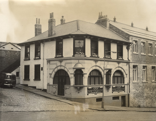
Former Hawthorne Inn
- Overview Map Street View Sachins Punjabi Restaurant is located on Forth Banks, by the junction with Forth Street in Newcastle. The building was formerly the Hawthorne Inn public house (shown …
Co-Curate Page
Church of St John, Whorlton, Westerhope
- Overview Map Street View The Church of St John in Whorlton, Westerhope was originally built in 1866 as a Chapel of Ease to Newburn. In c.1911 the east end of …
Co-Curate Page
Church of St Augustine
- Overview Map Street View The Church of Augustine of Hippo (now St George & St. Athanasius Coptic Orthodox Church) is located on Brighton Grove in Fenham, Newcastle. The church was …
Co-Curate Page
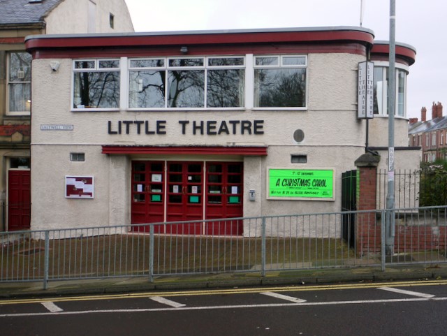
Little Theatre
- Overview About The Little Theatre Map Street View The Little Theatre is located on Saltwell View, Gateshead. The Theatre was established by the Progressive Players and the opening performance was …
Co-Curate Page
Ridley Villas, 91 New Bridge Street
- Ridley Villas, 91 New Bridge Street, Newcastle, were built in the 1820s. They were once part of a row of grand residential houses, possibly designed by John Dobson. The villas …
Co-Curate Page
Bay View House (former Rex Hotel)
- Overview Map Street View Bay View House is located on the corner of Promenade and South Parade in Whitley Bay. This is the former 70 bedroom Rex Hotel, which closed in 2016. …
Co-Curate Page
Belle Grove pub (1875-2008)
- The Belle Grove public house on the corner of Belle Grove Terrace and Ancrum Street in Spital Tongues Newcastle, was built in c.1875. It was built for Sanderson's Haymarket Brewery and …
Co-Curate Page
Old Stainton School
- Overview Map Street View Stainton Board Schools (separate boys and girls schools within the building) was constructed in 1876 by the Stainton, Thornton and Maltby School Board. It replaced the …
Co-Curate Page
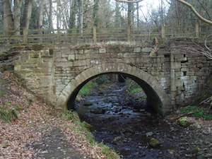
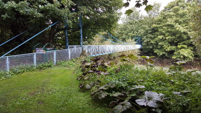
The Hikey Bridge
- The Sands Suspension Bridge, known locally as the 'Hikey Bidge', is a footbridge over the River Derwent at Swalwell, Gateshead. It was built in 1902 to link the allotments on …
Co-Curate Page
Middlehaven Public House, Stockton Street
- Overview Map Street View The Middlehaven was a public house on Stockton Street in the Middlehaven area of Middlesbrough. It was formerly called the Ship Inn, which was first licenced …
Co-Curate Page
Lions Head Fountain, Tynemouth Longsands
- The Lion’s Head Fountain on Tynemouth Longsands was built in 1863 utilising a natural mineral spring which had been used since the 1820s for its reputed health-giving properties. However, it …

Co-Curate Page
Rangefinder Pillar, St Mary's Island
- Overview Map Street View There is a concrete pillar on the rocks to the east of St Mary's Island. It was originally built in 1914 as a rangefinder to calibrate …
Co-Curate Page
Former Grand Hotel, Barras Bridge
- 1 - 24, Barras Bridge. This is a former hotel, built in 1902, now shops and accommodation. In 1958 it was bought by Newcastle University for use as student accommodation.
Co-Curate Page
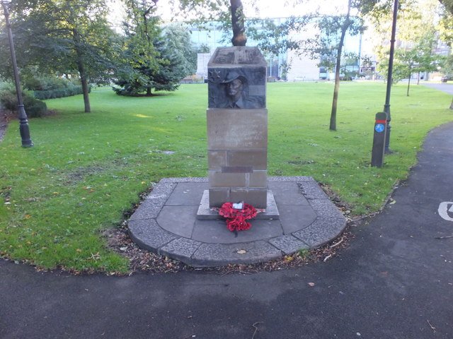
Burma War Memorial
- This memorial stands in the grounds of the Church of St Thomas the Martyr, by St Mary's Place in Newcastle. The bronze sculpture is by Nicholas Whitmore, commissioned by the …
Co-Curate Page
Cassie Building
- Overview Map Street View The Cassie Building at Newcastle University was built in 1955. The main entrance is on Kensington Walk - a walkway between Claremont Road and Kensington Terrace. …
Co-Curate Page
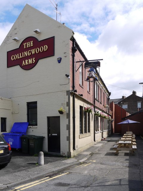
Collingwood Arms, Brandling Village
- Overview Map Street View The Collingwood Arms is a public house in Brandling Village, Jesmond. It first opened in 1836. The first landlord, Robert Hewlitt, named the pub after Newcastle-born …
Co-Curate Page
Cumberland Arms
- Overview Map Street View The Cumberland Arms is located on James Place Street in Ouseburn, Byker (rear to Back Stephen Street). The Cumberland Arms was first licensed as a beer …
Co-Curate Page
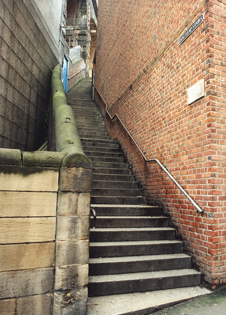
Dog Leap Stairs
- Historic steps from Castle Garth to Side in Newcastle. In 1772, the young Baron Eldon (John Scott) eloped with Bessie Surtees and the couple made their escape on horseback up Dog Leap …
Co-Curate Page
Heaton Baptist Church, Heaton Road
- Overview Map Street View Heaton Baptist Church, on the corner of Heaton Road and Mundella Terrace, was built in 1904. Plans to build the church began in 1895 when members …
Co-Curate Page
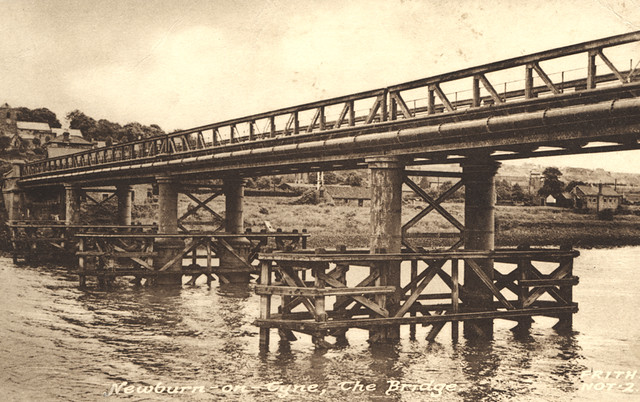
Newburn Bridge
- Overview About Newburn Bridge Map Street View Newburn Bridge is a road bridge over the River Tyne between Newburn in the City of Newcastle upon Tyne and Ryton in the …
Co-Curate Page
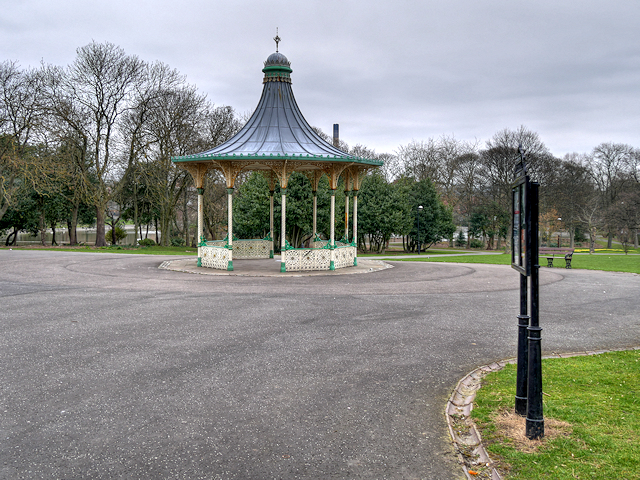
Bandstand, Leazes Park
- The bandstand in Leazes Park is a faithful reconstruction of the original 19th Century bandstand made in 2003. The ornate 10 sided bandstand, with it's crown domed roof is an …
Co-Curate Page
The Ritz, Wallsend
- Overview Map Street View The Ritz is a public house on High Street West in Wallsend. It was originally the Ritz Cinema, which opened on the 15th of May 1939 …
Co-Curate Page
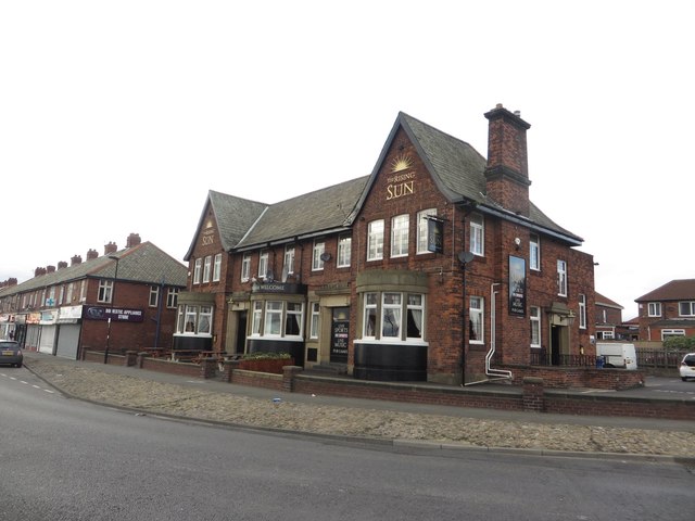
Rising Sun Inn
- Overview Map Street View The Rising Sun is a public house by the Coast Road in Wallsend. It was built in the 1930's to serve the new community in the …
Co-Curate Page
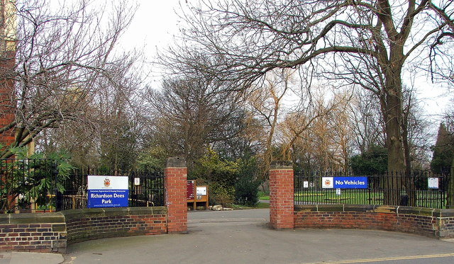
Richardson Dees Park, Wallsend
- Overview Map Street View "In 1897, local solicitor and benefactor Robert Richardson Dees donated fourteen acres of his Hall estate to the Urban District Council for use as a park. …
Co-Curate Page
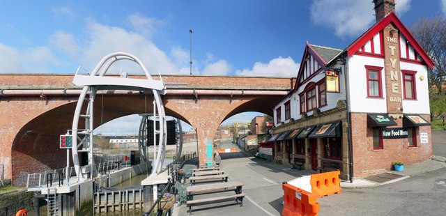
Tyne Bar, Ouseburn
- Overview Map Street View The Tyne Bar is a public house, located on Maling Street, by Glasshouse Bridge in Ouseburn, near the eastern end of the Quayside in Newcastle. It …
Co-Curate Page
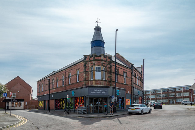
N.E. Co-op, John Street
- Overview Map Street View "This building was opened in 1895 by the North Shields Co-operative Society, subsequently North Eastern Co-operative Society. It is still in use by the Co-op. The building …
Co-Curate Page
Summerhill Square and Park
- Overview Map Street View Summerhill Square is an open space formed around the Georgian terraces of Summerhill Grove, Summerhill Terrace and Ravensworth Terrace / Greenfield Place / Swinburne Place. Summerhill Park, at …
Co-Curate Page
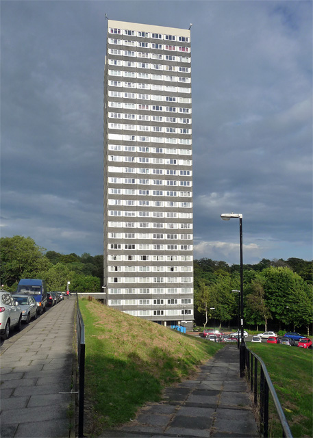
Vale House
- Overview Map Street View Vale House is a tower block on Lansdowne Gardens, overlooking Jesmond Vale, built in 1967 by Douglass Wise and Partners. The building has 28 floors and at …
Co-Curate Page
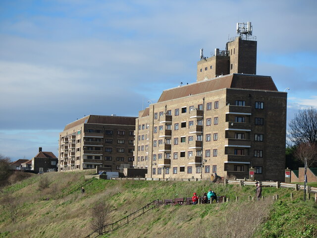
Sir James Knott Memorial Flats
- Overview Map Street View The Sir James Knott Memorial Flats on Tynemouth Road, overlooking the mouth of the Tyne, in North Shields and close to Tynemouth, were opened in 1939. …
Co-Curate Page
Willington Mill
- Overview Map Street View Willington Mill is situated by Willington Gut and located on Gut Road, off Ropery Lane. Constructed around 1805, this is a four-storey brick-built corn mill with …
Co-Curate Page
The Ship Inn, Benton
- Overview Map Street View Inside The Ship Inn on Front Street in Benton dates from 1904. The Ship Inn is listed on North Tyneside Council's register of buildings and parks …
Co-Curate Page
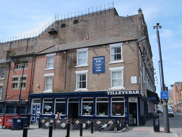
Tilley's Bar, Westgate Road
- Overview Map Street View Tilley's Bar is located next to the Tyne Theatre, on the corner of Westgate Road and Thornton Street in Newcastle. The building dates from the mid …
Co-Curate Page
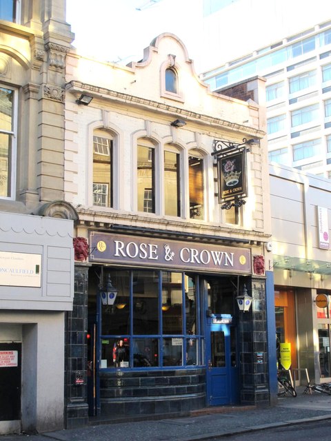
Rose and Crown, Newgate Street
- Overview Map Street View The Rose and Crown is a public house located on Newgate Street in Newcastle. It was built for Duncan and Dalglish in c.1914, designed by Simpson and …
Co-Curate Page
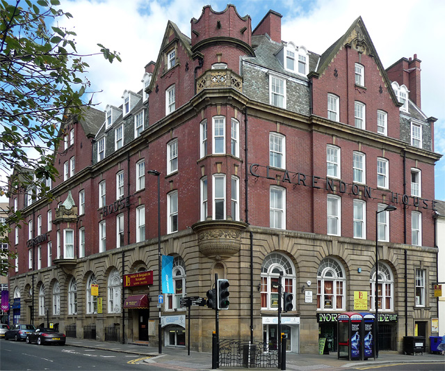
Clarendon House, Clayton Street West
- Overview Map Street View Clarendon House on the corner of Clayton Street West and Bewick Street in Newcastle was originally built as a temperence hotel. It was designed by Oliver …
Co-Curate Page
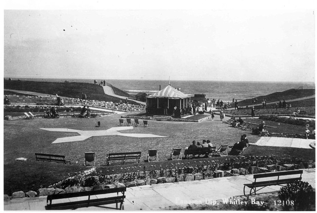
Panama Gardens
- Overview Map Street View In October 1932 Whitley & Monkseaton Urban District Council discussed a scheme for sunken gardens on The Links between Watts Road and Panama House (a cafe …
Co-Curate Page
91-93 Westgate Road, Newcastle
- Nos. 91-93 Westgate Road, Newcastle, was originally built in c.1900 for Lockhart's Cocoa Rooms.
Co-Curate Page
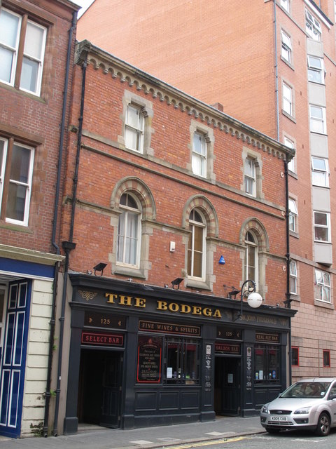
The Bodega, Westgate Road
- Overview Map Street View The Bodega is a public house on Westgate Road (no. 125), in Newcastle. Local List. "Designed by Septimus Oswald c.1872. This was a rebuild of the …
Co-Curate Page
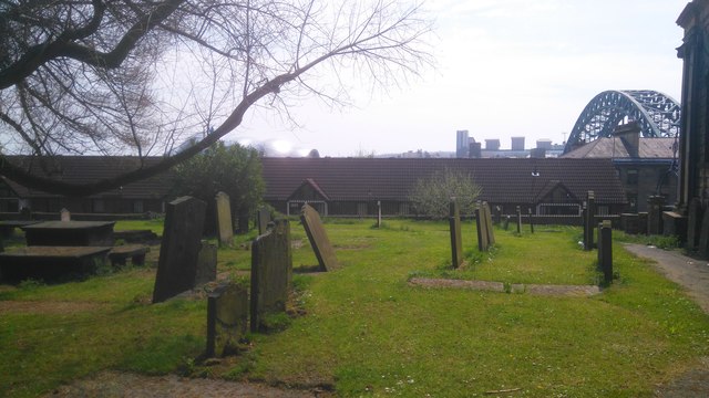
Ballast Hills Graveyard
- Overview Map Street View Ballast Hills, Ouseburn / Byker. This was a non-conformist burial ground associated with the influx of foreign (some adopting Quakerism) and Scottish families (many Presbyterians) into …
Co-Curate Page
110-116 Grey Street, Newcastle
- Nos. 110-116 Grey Street, Newcastle, is an Edwardian building, originally the Victoria Music Hall, and later a billiard salon. Then in 1914, the building was remodelled by White and Stephenson …
Co-Curate Page
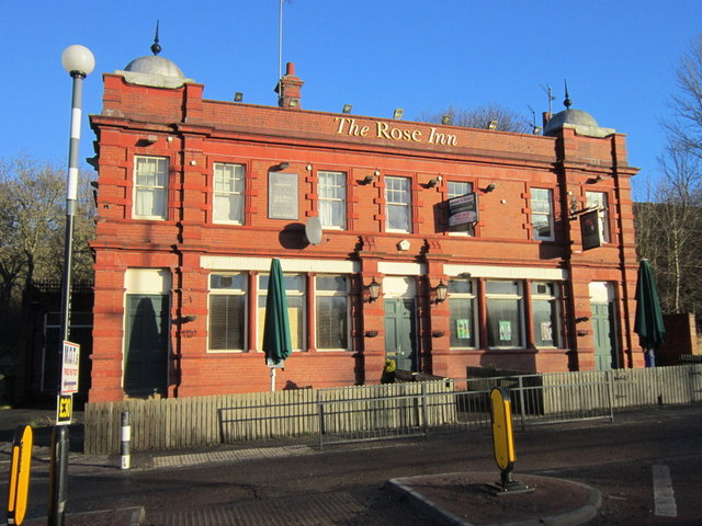
Rose Inn, Rosehill Bank
- Overview Map Street View The Rose Inn is a public house located on Rosehill Bank in the Rosehill area of Wallsend. The ornate terracotta two storey public house opened in …
Co-Curate Page
Richardson Dees Primary School
- Overview Map Street View Richardson Dees Primary School is located on High Street East in Wallsend. It is a Foundation school, under North Tyneside Learning Trust. The school has about …
Co-Curate Page
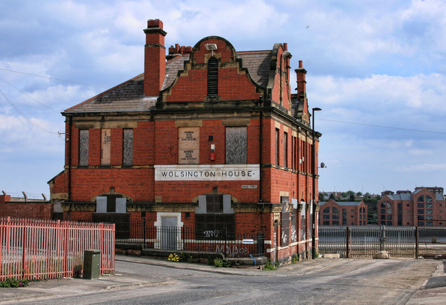
Wolsington House
- Overview Map Street View Wolsington House is a former public house on Burdon Main Row, by the Dock Road Industrial Estate, in North Shields. It is situated on an elavated …
Co-Curate Page
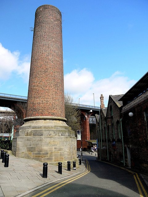
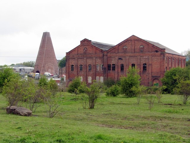
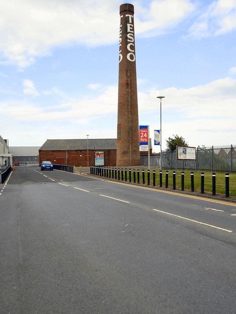
Tesco Chimney, West Chirton
- Overview Map Street View The 'Tesco Chimney' is located by the Tesco Extra store off Norham Road, on the West Chirton Industrial Estate, in North Shields. It is a surviving …
Co-Curate Page
Monkseaton Methodist Church
- Overview Map Street View Monkseaton Methodist Church is located on Front Street in Monkseaton. The building was originally a byre, stable and turnip house, forming part of Monkseaton Village Farm. …
Co-Curate Page
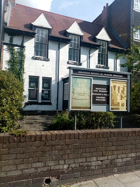
Friends Meeting House, Monkseaton
- Overview Map Street View This Friends Meeting House is located at No. 23, Front Street, in Monkseaton. The building was originally a single storey cottage (Gourd Cottage) associated with Monkseaton …
Co-Curate Page
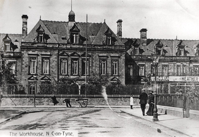
Newcastle upon Tyne Poor Law Union Workhouse
- Newcastle-upon-Tyne Poor Law Union formally came into existence on the 26th September 1836. THE UNION WORKHOUSE is situated in this township, about one mile west of Newcastle. It is a …
Co-Curate Page
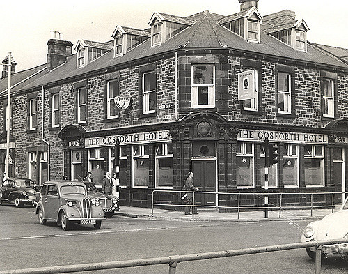
The Gosforth Hotel
- Overview Map Street View The Gosforth Hotel is a public house, located on the High Street, by the junction with Salters Road in Gosforth. It was built in 1878 and …
Co-Curate Page
Galen House, Low Friar Street
- Overview Map Street View Galen House is located on the corner of Low Friar Street and Dispensary Lane in Newcastle. The building dates from c.1901 and was designed by Matthew …
Co-Curate Page
All Saint's Churchyard, Newcastle
- Overview Map Street View The churchyard of All Saints Church on Akenside Hill, by the lower end of Pilgrim Street and Dog Bank, is a significant green space in the …
Co-Curate Page
Central Buildings, 7-9, Bigg Market
- Overview Map Street View Nos. 7-9 Bigg Market in Newcastle were originally a public house, offices and warehouses. A date stone on the building states "Established 1822, Rebuilt 1897". The …
Co-Curate Page
Subterranean WC, Bigg Market
- Overview Map Street View At the south end of the Bigg Market, in Newcastle, are the former public lavatories with circular railings around the underground the gents toilet. It opened …
Co-Curate Page
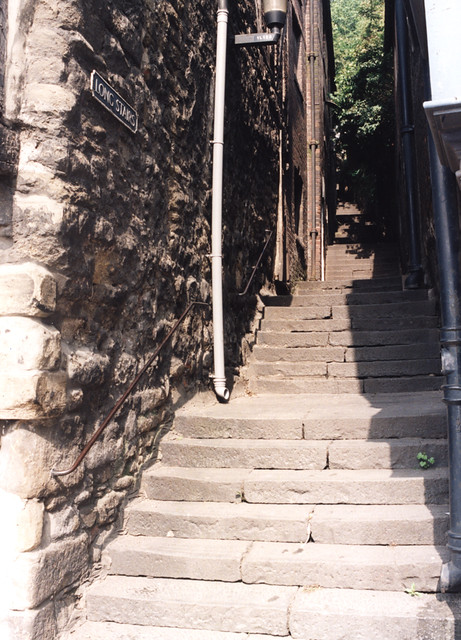
Long Stairs
- Overview Map Street View The historic Long Stairs in Newcastle start on the Close between the 15th century Cooperage and 16th century “Buttress” merchant’s house, leading up to Queen's Lane, …
Co-Curate Page
Hanging Gardens, Close
- Overview Map Street View The Hanging Gardens (now closed to the public) are a landscaped area on the steeply sloping bank running from Hanover Street down to Close, in Newcastle. …
Co-Curate Page
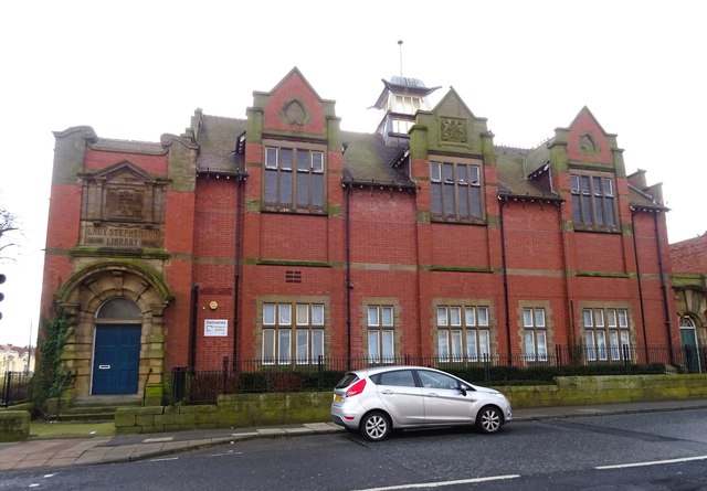
Old Library, Walker
- Overview Map Street View The former Walker Library building is located on Welbeck Road in Walker, Newcastle. It was opened as the Lady Stephenson Library in 1908, commissioned by the …
Co-Curate Page
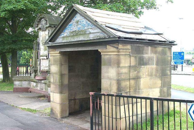
Fleming Memorial Patients' Shelter
- Overview Map Street View This Patients Shelter of the former Fleming Memorial Hospital is located by the junction of the Great North Road and Clayton Road in Jesmond, Newcastle. It …
Co-Curate Page
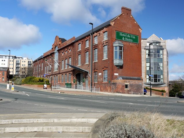
Allan House, City Road
- Overview Map Street View Allan House (now Hotel du Vin & Bistro) is located on City Road, by the junction with Ouse Street, in Newcastle. It was orininally built as …
Co-Curate Page
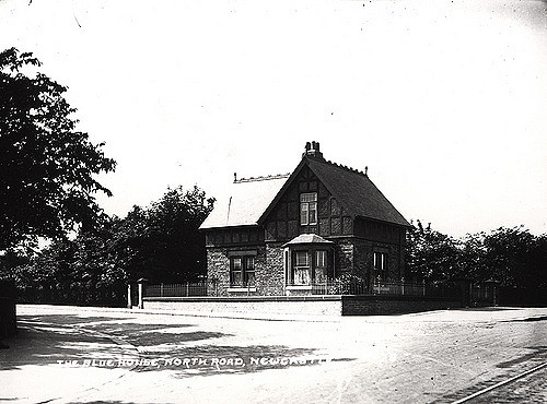
Blue House, Great North Road
- Overview Map Street View The Blue House on Town Moor in Newcastle is located on the juction of Grandstand Road and the Great North Road - and gives its name …
Co-Curate Page
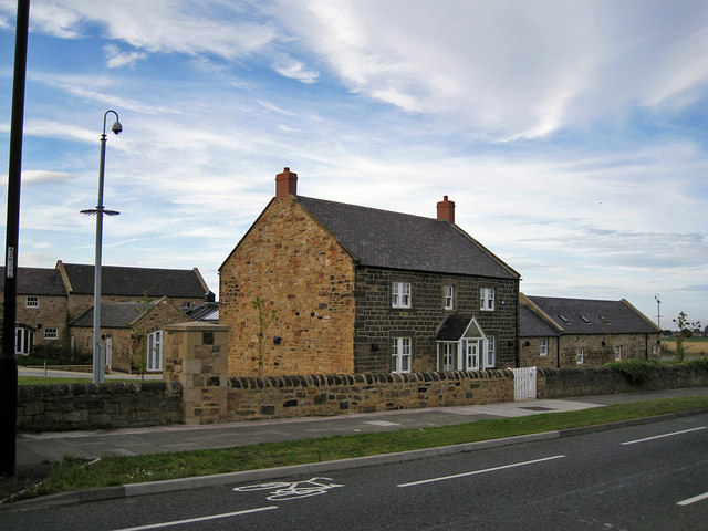
West Fellgate Farm
- Overview Map Street View West Fellgate Farm is located off Leam Lane, Fellgate, in South Tyneside. The farm building dates from the 19th century. The farmhouse and West Fellgate Cottage …
Co-Curate Page
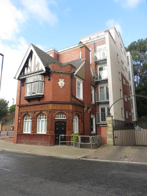
Crane House, Duke Street
- Overview Map Street View Crane House Vaults is a former public house, now apartments, located on Duke Street in North Shields, opposite Ferry Mews. The building has an attractive glazed …
Co-Curate Page
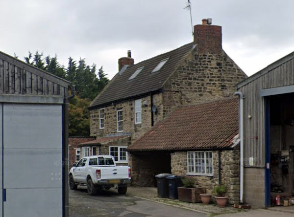
Rake House Farm
- Overview Map Street View Rake House is a small-business and office complex, based on a former farm on Rake Lane in Preston Grange, North Shields. The former farmhouse dates from …

Co-Curate Page
Linthorpe Community Primary School
- Overview Map Street View Linthorpe Community Primary School is located on Roman Road in Linthorpe, Middlesbrough. The school has about 730 pupils aged 2 to 11. In January 2004 it …
Co-Curate Page
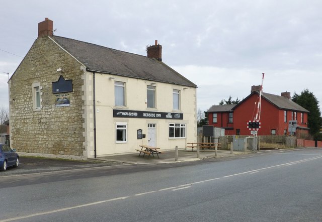
Bebside Inn
- Overview Map Street View The Bebside Inn (affectionately known as "The Bebby") is a public house located on Front Street in Bebside, Blyth. The inn was redeveloped and reopened in …
Co-Curate Page
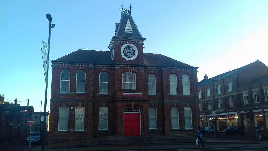
Library
- Overview Map Street View The Library is located at No. 20, Bridge Street, in Blyth. The building, with its distinctive clock tower, was originally a Mechanics Institute built in a …

Co-Curate Page
No. 20 Collingwood Street
- Built in 1889 by R K Freeman and Robins for Mr Swanson. The building is on the Local List.
Co-Curate Page
Church of St. Joseph
- St Joesph's Church in Benwell is located at the junction of Armstrong Road and South Benwell Road. The neo-Byzantine style building was designed by Stienlet & Maxwell and opened in October …
Co-Curate Page
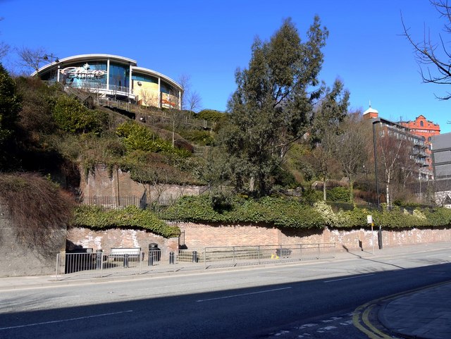
Benwell Nature Park
- Overview About Map Street View Benwell Nature Park was established in 1982 on land cleared by the demolition of two streets of terraced housing and a section of Atkinson Road in …
Co-Curate Page
Monkseaton Station
- Overview About Map Street View The railway station at Monkseaton opened 25th July 1915, replacing the former Whitley Junction station of 1860, which was located in what is now Souter Park. …
Co-Curate Page
Cullercoats Metro Station
- Overview About Map Street View The Metro station at Cullercoats was originally a railway station, which opened on the 7th July 1882. The station was built by the North Eastern …
Co-Curate Page
South Shields, Ferry Landing
- Overview Map Street View The new landing for the Shields Ferry in South Shields was built by Harbour & General at the Pallion Yard in Sunderland. The landing is made of …
Co-Curate Page
Rendezvous Cafe
- Overview Map Street View The iconic Art Deco style cafe at Duke's Walk by the North Promenade was built in June 1930 by Whitley Bay & District Council, and originally …
Co-Curate Page
New Coliseum
- Overview Map Street View Former theatre and cinema at no's 246-248 Whitley Road. The grand façade of the New Coliseum is a feature of the town centre in Whitley Bay. …
Co-Curate Page
Dove Marine Laboratory
- Overview About Map Street View The first laboratory at Cullercoats was constructed by the Northumberland Sea Fisheries Committee and opened on the 21st of October 1897.[1] It was a small wooden …
from https://sitelines.newcastle.g…
Tyne and Wear HER(7423): Chopwell, Church of St. John the Evangelist
- "This beautifully finished and well-kept turn of the 20th century rural church is in snecked, tooled, golden sandstone with ashlar details. Below the small bell turret the stonework advances, giving …
Added by
Simon Cotterill
Co-Curate Page
Church of St. John the Evangelist, Chopwell
- Overview Map Street View The Church of St. John the Evangelist in Chopwell opened in 1909. It replaced an existing smaller church, as the parish population had expanded rapidy with …
Co-Curate Page
The Ritz, Forest Hall
- Overview Map Street View The 'Ritz' Bingo & Social Club in Forest Hall was originally a cinema. The Ritz cinema, with 1,062 seats, opened on the 9th November 1936 with …
Co-Curate Page
Church of St Anne
- Overview Map Street View St Anne's Church in Winlaton was built in 1962 and is part of the Roman Catholic diocese of Hexham and Newcastle.
Co-Curate Page
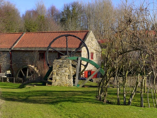
Path Head Water Mill, Blaydon
- Overview Map Street View The 18th Century Water Mill at Path Head, on Summerhill near Blaydon. The mill was derelict by 1974, but has been restored and renovated by the Vale …
Co-Curate Page
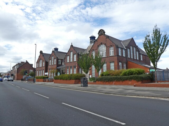
Cragside Primary School, High Heaton
- Overview Map Street View High Heaton Infants School ('the wooden school') opened on the 20th of August 1929 with a roll of 164 students. With a growing population in High …
Co-Curate Page
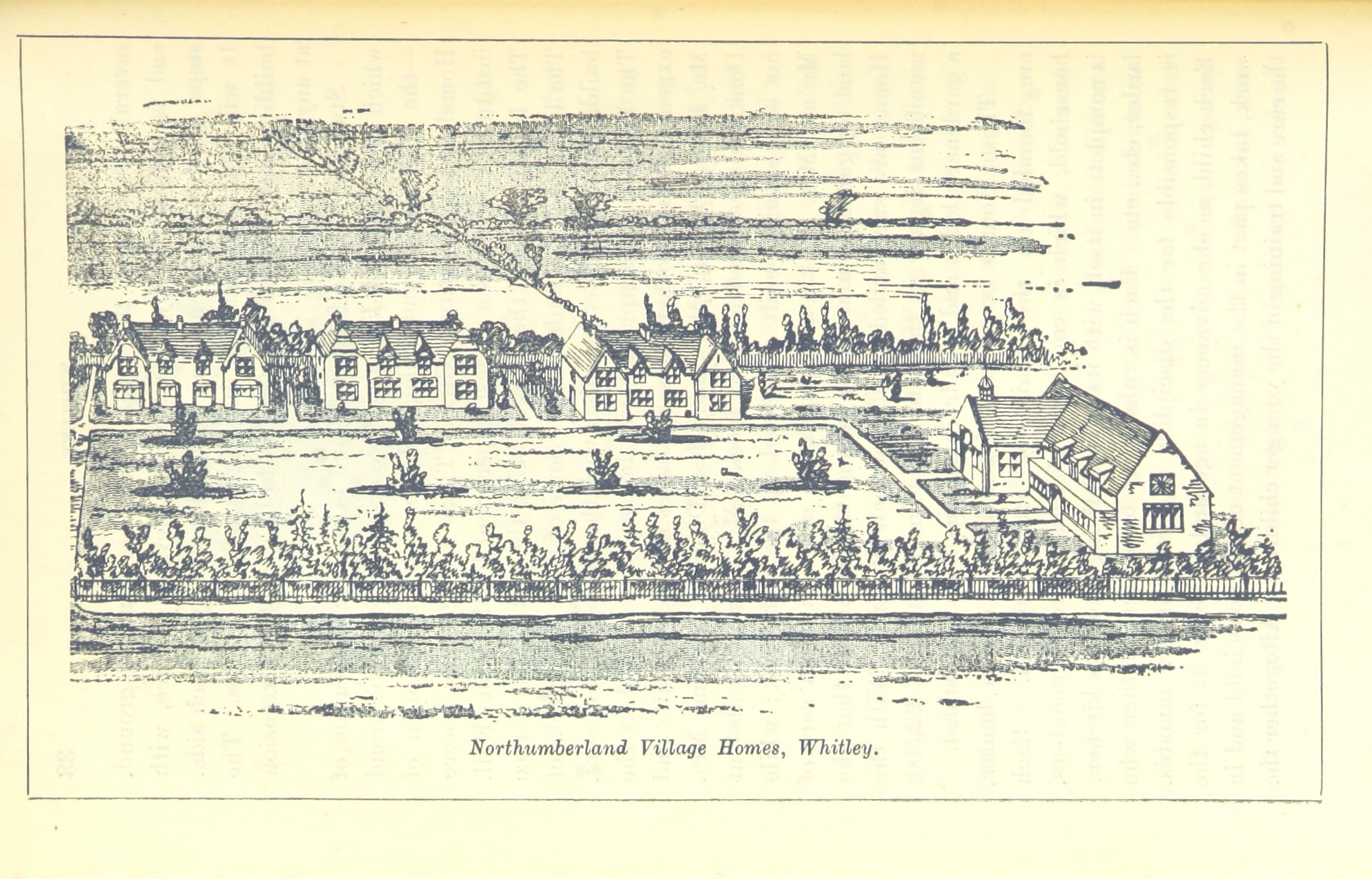
Northumberland Village Homes
- Overview Map Street View Village Court is tucked away off Norham Road by Monkseaton Metro Station. It has an interesting history... Northumberland Village Homes in Whitley Bay were built in …
Co-Curate Page
Old Eldon Square
- Overview About Old Eldon Square Map Street View Old Eldon Square off Blackett Street was built 1825 - 1831 as part of the mid 19th century redevelopment of Newcastle city centre. …
Co-Curate Page
Baltic Centre for Contemporary Art
- Overview About the Baltic Map Street View The original Baltic Flour Mills were opened in 1950, built for the Rank Hovis company based on a 1930s design by Gelder and …
Co-Curate Page
Marsden Grotto
- Summary About Marsden Grotto Map Street View Marsden Grotto is a 'cave bar' pub and restaurant on the coast at South Shields. It's history can be traced back to 1782 …
Co-Curate Page
Whitburn Methodist Church
- Overview Map Street View Whitburn Methodist Church is located on North Guards in Whitburn. It was built in 1881 to replace an earlier Wesleyan Chapel of 1812.[1] A tapered octagonal tower …
Co-Curate Page
Grants Clock
- Overview Map Street View There is a clock with 2 faces located on the Promenade in Whitley Bay, close to the junction with South Parade. The clock stands on a …
Co-Curate Page
Cross House
- Overview Map Street View Cross House is a distinctive office building on the corner of Westgate Road and Fenkle Steet in Newcastle. It was designed by Cackett and Burns Dick architects …
Co-Curate Page
Old Cooperative Warehouse, Stowell Street
- Overview Map Street View 14-18 Stowell Street is the former warehouse of the Co-operative Wholesale Society, built in 1908. The warehouse was used for ripening fruit and had loading bays …
Co-Curate Page
Stage Door Nightclub, Stowell Street
- Overview Map Street View Now 'The Cosmic Ballroom' nightclub. The building at 20-22 Stowell Street was originally a warehouse, and was converted into a casino known as 'The Bird Cage' …
Co-Curate Page
Nos. 34-46 Stowell Street
- Overview Map Street View Nos. 34-46 are the only remaining original buildings from when Stowell Street was first built c.1824.[1] The buildings now house a number of restaurants.
Co-Curate Page
Exhibition Park
- Overview About Exhibition Park Map Street View Exhibition Park is a short walk from Newcastle City Centre; the main entrance is off Claremont Road. It became known as Exhibition Park …
Co-Curate Page
Byker Bridge
- Overview About Byker Bridge Map Street View The Byker Bridge is a 344.65m (1130 ft) long road bridge that carries the A193 road over the River Ouseburn in Newcastle …
Co-Curate Page
The Mansion House, Fernwood Road
- Overview Map Street View The Mansion House on Fernwood Road in Jesmond is the official residence of the Lord Mayor of Newcastle. It was originally built in 1880 as two …
Co-Curate Page
Quadrangle
- Overview Map Street View The Quadrangle lies at the heart of Newcastle University with gardens and thoroughfare, which is a favourite place for graduation photographs. It is surrounded on all sides, …
Co-Curate Page
People's Theatre
- Overview About the Prople's Theatre Map Street View 1959: "The unfailing support of the Tyneside audience for our choice of play encourages us to purchase the Lyric Cinema, Heaton. It …
Co-Curate Page
Marden Bridge Middle School
- Overview Map Street View Marden Bridge Middle School is located on Lovaine Avenue in Whitley Bay. It is a community school with about 530 pupils aged 9 to 13.[1] The school …
Co-Curate Page
Ravenswood Primary School
- Overview Map Street View Located on Ravenswood Road in Heaton, Ravenswood is one of the largest primary schools in Newcastle. It is a foundation school with about 650 pupils aged …
Co-Curate Page
Danby House and Blacksmith’s Forge
- Overview Map Street View Danby House at 321 Acklam Road, is a former small holding and part of the former village of Acklam, before it became part of Middlesbrough. It …
Co-Curate Page
Drinking Fountain, Stokesley Road, Marton
- Overview Map Street View Dated 1879 and located on Stokesley Road, opposite St Cuthbert’s Church, and at the south-west corner of Stewart Park in Marton. The drinking fountain was built …
Co-Curate Page
House of Fraser, 37 Linthorpe Road
- Overview Map Street View The House of Fraser Department Store (37 Linthorpe Road) is located in Middlesbrough town centre on the corner of Newport Road and Linthorpe Road. Built in …
Co-Curate Page
Miss Selfridge, 64-66 Linthorpe Road
- Overview Map Street View Nos. 64-66 Linthorpe Road in Middlesbrough is a Miss Selfridge store on the corner of Linthorpe Road and Corporation Road. The building was originally built in …
Co-Curate Page
The Crown
- Overview Map Street View The Crown is a prominent building on the corner of Linthorpe Road and Borough Road, Middlesbrough. The building was designed by architect James Forbes, and was …
Co-Curate Page
Methodist Church, 126-132 Linthorpe Road
- Overview Map Street View Built as a Methodist Church and Sunday School in 1892, located on the corner of Linthorpe Road and Borough Road in Middlesbrough. Today the church still …
Co-Curate Page
Dr Brown's, Corporation Road
- Overview Map Street View Doctor Brown's pub is located on the junction of Corporation Road and Marton Road in the centre of Middlesbrough. The triangular building was originally built as …
Co-Curate Page
72-80 Corporation Road
- Overview Map Street View 72-80 Corporation Road, Middlesbrough was originally built in c.1898 as a shop, warehouse and offices for the Middlesbrough Co-operative Society. During the 1940’s and 1950’s the building …
Co-Curate Page
82-90 Corporation Road
- Overview Map Street View 82-90 Corporation Road in Middlesbrough was built in 1881. It was designed by William Duncan and Roger Lofthouse for the Middlesbrough Co-operative Society Branch, to house …
Co-Curate Page
Hawthorne House
- Overview Map Street View Hawthorne House is a 3 storey brick and stone Georgian building on Forth Banks in Newcastle. It was part of the former Hawthorn Engineering Works, whose …
Co-Curate Page
Former Hawthorne Inn
- Overview Map Street View Sachins Punjabi Restaurant is located on Forth Banks, by the junction with Forth Street in Newcastle. The building was formerly the Hawthorne Inn public house (shown …
Co-Curate Page
Church of St John, Whorlton, Westerhope
- Overview Map Street View The Church of St John in Whorlton, Westerhope was originally built in 1866 as a Chapel of Ease to Newburn. In c.1911 the east end of …
Co-Curate Page
Church of St Augustine
- Overview Map Street View The Church of Augustine of Hippo (now St George & St. Athanasius Coptic Orthodox Church) is located on Brighton Grove in Fenham, Newcastle. The church was …
Co-Curate Page
Little Theatre
- Overview About The Little Theatre Map Street View The Little Theatre is located on Saltwell View, Gateshead. The Theatre was established by the Progressive Players and the opening performance was …
Co-Curate Page
Ridley Villas, 91 New Bridge Street
- Ridley Villas, 91 New Bridge Street, Newcastle, were built in the 1820s. They were once part of a row of grand residential houses, possibly designed by John Dobson. The villas …
Co-Curate Page
Bay View House (former Rex Hotel)
- Overview Map Street View Bay View House is located on the corner of Promenade and South Parade in Whitley Bay. This is the former 70 bedroom Rex Hotel, which closed in 2016. …
Co-Curate Page
Belle Grove pub (1875-2008)
- The Belle Grove public house on the corner of Belle Grove Terrace and Ancrum Street in Spital Tongues Newcastle, was built in c.1875. It was built for Sanderson's Haymarket Brewery and …
Co-Curate Page
Old Stainton School
- Overview Map Street View Stainton Board Schools (separate boys and girls schools within the building) was constructed in 1876 by the Stainton, Thornton and Maltby School Board. It replaced the …
Co-Curate Page
The Hikey Bridge
- The Sands Suspension Bridge, known locally as the 'Hikey Bidge', is a footbridge over the River Derwent at Swalwell, Gateshead. It was built in 1902 to link the allotments on …
Co-Curate Page
Middlehaven Public House, Stockton Street
- Overview Map Street View The Middlehaven was a public house on Stockton Street in the Middlehaven area of Middlesbrough. It was formerly called the Ship Inn, which was first licenced …
Co-Curate Page
Lions Head Fountain, Tynemouth Longsands
- The Lion’s Head Fountain on Tynemouth Longsands was built in 1863 utilising a natural mineral spring which had been used since the 1820s for its reputed health-giving properties. However, it …
Co-Curate Page
Rangefinder Pillar, St Mary's Island
- Overview Map Street View There is a concrete pillar on the rocks to the east of St Mary's Island. It was originally built in 1914 as a rangefinder to calibrate …
Co-Curate Page
Former Grand Hotel, Barras Bridge
- 1 - 24, Barras Bridge. This is a former hotel, built in 1902, now shops and accommodation. In 1958 it was bought by Newcastle University for use as student accommodation.
Co-Curate Page
Burma War Memorial
- This memorial stands in the grounds of the Church of St Thomas the Martyr, by St Mary's Place in Newcastle. The bronze sculpture is by Nicholas Whitmore, commissioned by the …
Co-Curate Page
Cassie Building
- Overview Map Street View The Cassie Building at Newcastle University was built in 1955. The main entrance is on Kensington Walk - a walkway between Claremont Road and Kensington Terrace. …
Co-Curate Page
Collingwood Arms, Brandling Village
- Overview Map Street View The Collingwood Arms is a public house in Brandling Village, Jesmond. It first opened in 1836. The first landlord, Robert Hewlitt, named the pub after Newcastle-born …
Co-Curate Page
Cumberland Arms
- Overview Map Street View The Cumberland Arms is located on James Place Street in Ouseburn, Byker (rear to Back Stephen Street). The Cumberland Arms was first licensed as a beer …
Co-Curate Page
Dog Leap Stairs
- Historic steps from Castle Garth to Side in Newcastle. In 1772, the young Baron Eldon (John Scott) eloped with Bessie Surtees and the couple made their escape on horseback up Dog Leap …
Co-Curate Page
Heaton Baptist Church, Heaton Road
- Overview Map Street View Heaton Baptist Church, on the corner of Heaton Road and Mundella Terrace, was built in 1904. Plans to build the church began in 1895 when members …
Co-Curate Page
Newburn Bridge
- Overview About Newburn Bridge Map Street View Newburn Bridge is a road bridge over the River Tyne between Newburn in the City of Newcastle upon Tyne and Ryton in the …
Co-Curate Page
Bandstand, Leazes Park
- The bandstand in Leazes Park is a faithful reconstruction of the original 19th Century bandstand made in 2003. The ornate 10 sided bandstand, with it's crown domed roof is an …
Co-Curate Page
The Ritz, Wallsend
- Overview Map Street View The Ritz is a public house on High Street West in Wallsend. It was originally the Ritz Cinema, which opened on the 15th of May 1939 …
Co-Curate Page
Rising Sun Inn
- Overview Map Street View The Rising Sun is a public house by the Coast Road in Wallsend. It was built in the 1930's to serve the new community in the …
Co-Curate Page
Richardson Dees Park, Wallsend
- Overview Map Street View "In 1897, local solicitor and benefactor Robert Richardson Dees donated fourteen acres of his Hall estate to the Urban District Council for use as a park. …
Co-Curate Page
Tyne Bar, Ouseburn
- Overview Map Street View The Tyne Bar is a public house, located on Maling Street, by Glasshouse Bridge in Ouseburn, near the eastern end of the Quayside in Newcastle. It …
Co-Curate Page
N.E. Co-op, John Street
- Overview Map Street View "This building was opened in 1895 by the North Shields Co-operative Society, subsequently North Eastern Co-operative Society. It is still in use by the Co-op. The building …
Co-Curate Page
Summerhill Square and Park
- Overview Map Street View Summerhill Square is an open space formed around the Georgian terraces of Summerhill Grove, Summerhill Terrace and Ravensworth Terrace / Greenfield Place / Swinburne Place. Summerhill Park, at …
Co-Curate Page
Vale House
- Overview Map Street View Vale House is a tower block on Lansdowne Gardens, overlooking Jesmond Vale, built in 1967 by Douglass Wise and Partners. The building has 28 floors and at …
Co-Curate Page
Sir James Knott Memorial Flats
- Overview Map Street View The Sir James Knott Memorial Flats on Tynemouth Road, overlooking the mouth of the Tyne, in North Shields and close to Tynemouth, were opened in 1939. …
Co-Curate Page
Willington Mill
- Overview Map Street View Willington Mill is situated by Willington Gut and located on Gut Road, off Ropery Lane. Constructed around 1805, this is a four-storey brick-built corn mill with …
Co-Curate Page
The Ship Inn, Benton
- Overview Map Street View Inside The Ship Inn on Front Street in Benton dates from 1904. The Ship Inn is listed on North Tyneside Council's register of buildings and parks …
Co-Curate Page
Tilley's Bar, Westgate Road
- Overview Map Street View Tilley's Bar is located next to the Tyne Theatre, on the corner of Westgate Road and Thornton Street in Newcastle. The building dates from the mid …
Co-Curate Page
Rose and Crown, Newgate Street
- Overview Map Street View The Rose and Crown is a public house located on Newgate Street in Newcastle. It was built for Duncan and Dalglish in c.1914, designed by Simpson and …
Co-Curate Page
Clarendon House, Clayton Street West
- Overview Map Street View Clarendon House on the corner of Clayton Street West and Bewick Street in Newcastle was originally built as a temperence hotel. It was designed by Oliver …
Co-Curate Page
Panama Gardens
- Overview Map Street View In October 1932 Whitley & Monkseaton Urban District Council discussed a scheme for sunken gardens on The Links between Watts Road and Panama House (a cafe …
Co-Curate Page
91-93 Westgate Road, Newcastle
- Nos. 91-93 Westgate Road, Newcastle, was originally built in c.1900 for Lockhart's Cocoa Rooms.
Co-Curate Page
The Bodega, Westgate Road
- Overview Map Street View The Bodega is a public house on Westgate Road (no. 125), in Newcastle. Local List. "Designed by Septimus Oswald c.1872. This was a rebuild of the …
Co-Curate Page
Ballast Hills Graveyard
- Overview Map Street View Ballast Hills, Ouseburn / Byker. This was a non-conformist burial ground associated with the influx of foreign (some adopting Quakerism) and Scottish families (many Presbyterians) into …
Co-Curate Page
110-116 Grey Street, Newcastle
- Nos. 110-116 Grey Street, Newcastle, is an Edwardian building, originally the Victoria Music Hall, and later a billiard salon. Then in 1914, the building was remodelled by White and Stephenson …
Co-Curate Page
Rose Inn, Rosehill Bank
- Overview Map Street View The Rose Inn is a public house located on Rosehill Bank in the Rosehill area of Wallsend. The ornate terracotta two storey public house opened in …
Co-Curate Page
Richardson Dees Primary School
- Overview Map Street View Richardson Dees Primary School is located on High Street East in Wallsend. It is a Foundation school, under North Tyneside Learning Trust. The school has about …
Co-Curate Page
Wolsington House
- Overview Map Street View Wolsington House is a former public house on Burdon Main Row, by the Dock Road Industrial Estate, in North Shields. It is situated on an elavated …
Co-Curate Page
Tesco Chimney, West Chirton
- Overview Map Street View The 'Tesco Chimney' is located by the Tesco Extra store off Norham Road, on the West Chirton Industrial Estate, in North Shields. It is a surviving …
Co-Curate Page
Monkseaton Methodist Church
- Overview Map Street View Monkseaton Methodist Church is located on Front Street in Monkseaton. The building was originally a byre, stable and turnip house, forming part of Monkseaton Village Farm. …
Co-Curate Page
Friends Meeting House, Monkseaton
- Overview Map Street View This Friends Meeting House is located at No. 23, Front Street, in Monkseaton. The building was originally a single storey cottage (Gourd Cottage) associated with Monkseaton …
Co-Curate Page
Newcastle upon Tyne Poor Law Union Workhouse
- Newcastle-upon-Tyne Poor Law Union formally came into existence on the 26th September 1836. THE UNION WORKHOUSE is situated in this township, about one mile west of Newcastle. It is a …
Co-Curate Page
The Gosforth Hotel
- Overview Map Street View The Gosforth Hotel is a public house, located on the High Street, by the junction with Salters Road in Gosforth. It was built in 1878 and …
Co-Curate Page
Galen House, Low Friar Street
- Overview Map Street View Galen House is located on the corner of Low Friar Street and Dispensary Lane in Newcastle. The building dates from c.1901 and was designed by Matthew …
Co-Curate Page
All Saint's Churchyard, Newcastle
- Overview Map Street View The churchyard of All Saints Church on Akenside Hill, by the lower end of Pilgrim Street and Dog Bank, is a significant green space in the …
Co-Curate Page
Central Buildings, 7-9, Bigg Market
- Overview Map Street View Nos. 7-9 Bigg Market in Newcastle were originally a public house, offices and warehouses. A date stone on the building states "Established 1822, Rebuilt 1897". The …
Co-Curate Page
Subterranean WC, Bigg Market
- Overview Map Street View At the south end of the Bigg Market, in Newcastle, are the former public lavatories with circular railings around the underground the gents toilet. It opened …
Co-Curate Page
Long Stairs
- Overview Map Street View The historic Long Stairs in Newcastle start on the Close between the 15th century Cooperage and 16th century “Buttress” merchant’s house, leading up to Queen's Lane, …
Co-Curate Page
Hanging Gardens, Close
- Overview Map Street View The Hanging Gardens (now closed to the public) are a landscaped area on the steeply sloping bank running from Hanover Street down to Close, in Newcastle. …
Co-Curate Page
Old Library, Walker
- Overview Map Street View The former Walker Library building is located on Welbeck Road in Walker, Newcastle. It was opened as the Lady Stephenson Library in 1908, commissioned by the …
Co-Curate Page
Fleming Memorial Patients' Shelter
- Overview Map Street View This Patients Shelter of the former Fleming Memorial Hospital is located by the junction of the Great North Road and Clayton Road in Jesmond, Newcastle. It …
Co-Curate Page
Allan House, City Road
- Overview Map Street View Allan House (now Hotel du Vin & Bistro) is located on City Road, by the junction with Ouse Street, in Newcastle. It was orininally built as …
Co-Curate Page
Blue House, Great North Road
- Overview Map Street View The Blue House on Town Moor in Newcastle is located on the juction of Grandstand Road and the Great North Road - and gives its name …
Co-Curate Page
West Fellgate Farm
- Overview Map Street View West Fellgate Farm is located off Leam Lane, Fellgate, in South Tyneside. The farm building dates from the 19th century. The farmhouse and West Fellgate Cottage …
Co-Curate Page
Crane House, Duke Street
- Overview Map Street View Crane House Vaults is a former public house, now apartments, located on Duke Street in North Shields, opposite Ferry Mews. The building has an attractive glazed …
Co-Curate Page
Rake House Farm
- Overview Map Street View Rake House is a small-business and office complex, based on a former farm on Rake Lane in Preston Grange, North Shields. The former farmhouse dates from …
Co-Curate Page
Linthorpe Community Primary School
- Overview Map Street View Linthorpe Community Primary School is located on Roman Road in Linthorpe, Middlesbrough. The school has about 730 pupils aged 2 to 11. In January 2004 it …
Co-Curate Page
Bebside Inn
- Overview Map Street View The Bebside Inn (affectionately known as "The Bebby") is a public house located on Front Street in Bebside, Blyth. The inn was redeveloped and reopened in …


