Topics > Carlisle > Historic Buildings and Monuments in Carlisle
Historic Buildings and Monuments in Carlisle
Listed buildings and scheduled monuments in Carlisle, Cumbria, from the National Heritage List for England[1]. In the absence of a published 'local list', some other public buildings of interest are also be included. Use the Search (below) if looking for a specific building / monument. Jump to photos and more detailed information.
| Structure | List No. | Grade | Built~ | Ward~ | Note |
|---|---|---|---|---|---|
| Nos. 1, 3 and 5, Alfred Street North | 1208730 | II | Castle | ||
| Nos. 1 and 3, Abbey Street | 1196976 | II | C18th | Castle | Abbey Street |
| No. 1, Earl Street | 1196972 | II | 1830s | Castle | Earl Street |
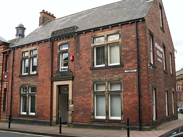
| No. 1, Fisher Street | 1209979 | II | C19th | Castle | Fisher Street |
| No. 1, Greenmarket | 1297359 | II | C18th | Castle | Greenmarket / Castle |
| No. 1, Howard Place | 1297382 | II | 1860s | Castle | |
| No. 1, Lowthian Lane | 1208743 | II | 1851 | Castle | Lowther Lane / Lowther Street / Bank Street |
| No. 1, Victoria Place | 1196918 | II* | 1830s | Castle | |
| Nos. 1-13, Devonshiew Street | 1292521 | II | Castle | ||
| Nos. 1-21, Tait Street | 1196916 | II | Castle | ||
| Nos. 1-9, the Crescent | 1291802 | II | Castle | ||
| Nos. 10, 12 and 14, Lowther Street | 1217895 | II | 1868 | Castle | Lowther Street |
| Nos. 10-30, Tait Street | 1297403 | II | Castle | ||
| Nos. 105 and 107, Warwick Road | 1218895 | II | Castle | Warwick Road | |
| No. 109, Warwick Road | 1297276 | II | 1850s | Castle | Warwick Road |
| No. 11, Earl Street | 1209731 | II | 1830s | Castle | Earl Street |
| No. 11, English Street | 1209754 | II | C18th | Castle | English Street |
| No. 11, Fisher Street | 1292334 | II | c.1790 | Castle | Fisher Street |
| Nos. 11-29, Warwick Road | 1197142 | II | Castle | Warwick Road | |
| No. 111, Warwick Road | 1218898 | II | 1860s | Castle | Warwick Road |
| Nos. 113 and 115, Warwick Road | 1197147 | II | Castle | Warwick Road | |
| Nos. 117, 119 and 121, Warwick Road | 1291718 | II | Castle | Warwick Road | |
| Nos. 12, 14 and 16, Devonshire Street | 1292525 | II | Castle | ||
| Nos. 13 and 15 Castle Street and 2 Paradise Court | 1292899 | II | Castle | Castle Street | |
| Nos. 13 and 15, English Street | 1196975 | II | Castle | English Street | |
| No. 13, Earl Street | 1297350 | II | 1862 | Castle | Earl Street |
| Nos. 14 and 16, Castle Street | 1196991 | II | Castle | Castle Street | |
| Nos. 15 and 17, Lowther Street | 1297407 | II | 1904 | Castle | Entrance to Lowther Arcade |
| No. 15, Portland Square | 1196903 | II | Castle | ||
| No. 15a, Abbey Street | 1297354 | II | Castle | Abbey Street | |
| Nos. 16-19, Portland Square | 1297394 | II | Castle | ||
| Nos. 17 and 19, Abbey Street | 1196979 | II | Castle | Abbey Street | |
| No. 17, Castle Street | 1208982 | II | Castle | Castle Street | |
| No. 17, Fisher Street | 1210006 | II | Castle | Fisher Street | |
| No. 17, Scotch Street | 1291901 | II | Castle | ||
| Nos. 18 and 20, Chiswick Street | 1292597 | II | Castle | ||
| Nos. 18, 20 and 22, Abbey Street | 1196980 | II | Castle | Abbey Street | |
| No. 18, Fisher Street | 1196951 | II* | C18th | Castle | Fisher Street |
| Nos. 19 and 21, Fisher Street | 1292379 | II | Castle | Fisher Street | |
| Nos. 19, 21 and 23, Victoria Place | 1197137 | II* | 1870s | Castle | |
| No. 19, Castle Street | 1025283 | II | Castle | Castle Street | |
| Nos. 2 and 4, Devonshire Street | 1297388 | II | Castle | ||
| Nos. 2 and 4, Hartington Place | 1210142 | II | Castle | ||
| Nos. 2 and 4, Howard Place | 1292288 | II | Castle | ||
| Nos. 2 and 4, Spencer Street | 1291829 | II | Castle | ||
| Nos. 4-18 Victoria Place, No. 2, Albert Street | 1297274 | II* | 1854 | Castle | |
| No. 2, Greenmarket | 1210127 | II | Castle | ||
| No. 2, Victoria Place | 1218796 | II* | 1830s | Castle | |
| Nos. 2-9, Chapel Street | 1196957 | II | C19th | Castle | |
| No. 20, Fisher Street | 1297379 | II | Castle | Fisher Street | |
| No. 20, Portland Square | 1196904 | II | Castle | ||
| Nos. 20-28, Scotch Street | 1291867 | II | Castle | ||
| Nos. 21 and 22, Portland Square | 1297395 | II | Castle | ||
| Nos. 21, 23 and 25, English Street | 1297374 | II | Castle | English Street | |
| No. 21, Castle Street | 1297358 | II* | C18th | Castle | Castle Street |
| Nos. 22 and 23, Chatsworth Square | 1196960 | II | Castle | ||
| Nos. 22 and 24, Hartington Place | 1196955 | II | Castle | ||
| No. 22, Chiswick Street | 1196963 | II | Castle | ||
| No. 22, Fisher Street | 1210040 | II | Castle | Fisher Street | |
| No. 23, Fisher Street | 1196952 | II | Castle | Fisher Street | |
| No. 23, Portland Square | 1196905 | II | Castle | ||
| Nos. 24 and 26, Chiswick Street | 1209529 | II | Castle | ||
| No. 24, Abbey Street | 1297355 | II* | C19th | Castle | Abbey Street |
| Nos. 25, 27 and 29, Tait Street | 1218743 | II | Castle | ||
| No. 26, Abbey Street | 1196981 | II* | C18th | Castle | Abbey Street |
| No. 27, Portland Square | 1196906 | II | Castle | ||
| Nos. 28 and 30, Abbey Street | 1208701 | II | Castle | Abbey Street | |
| Nos. 28, 30 and 32, Bank Street | 1208765 | II | Castle | ||
| No. 28, Portland Square | 1297396 | II | Castle | ||
| Nos. 3 and 4, Greenmarket | 1196954 | II | Castle | ||
| Nos. 3 and 5, Fisher Street | 1297378 | II | Castle | Fisher Street | |
| Nos. 3, 5 and 7, Earl Street | 1292508 | II | 1830s | Castle | Earl Street |
| Nos. 3, 5 and 7, Hartington Place | 1297381 | II | Castle | ||
| No. 3, Brunswick Street | 1292044 | II | Castle | ||
| No. 3, Castle Street | 1208937 | II | 1840s | Castle | Castle Street |
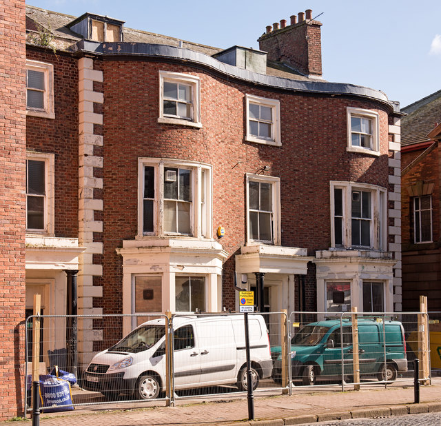
| Nos. 3-17, Victoria Place | 1197136 | II* | 1840s | Castle | |
| Nos. 31 and 33, Chiswick Street | 1196964 | II | Castle | ||
| Nos. 31-37, Fisher Street | 1292353 | II | Castle | Fisher Street | |
| Nos. 32, 34 and 36, Tait Street | 1196917 | II | Castle | ||
| Nos. 33-39, Lonsdale Street | 1217857 | II | Castle | ||
| No. 34, Abbey Street | 1297356 | II | Castle | Abbey Street | |
| No. 34, Fisher Street | 1210063 | II | Castle | Fisher Street | |
| No. 34, Scotch Street | 1297400 | II | Castle | ||
| Nos. 35-47, Chiswick Street | 1209537 | II | Castle | ||
| Nos. 35-49, Spencer Street | 1196915 | II | Castle | ||
| Nos. 36 and 38, Abbey Street | 1208715 | II | Castle | Abbey Street | |
| Nos. 36, 38 and 40, Scotch Street | 1218649 | II | Castle | ||
| Nos. 36-46, Victoria Place | 1197139 | II | Castle | ||
| Nos. 4 and 5, Paternoster Row | 1297372 | II | Castle | Paternoster Row | |
| Nos. 4, 6 and 6a, Lowther Street | 1196927 | II | 1830s | Castle | Lowther Street |
| Nos. 4, 6 and 8, Fisher Street | 1292362 | II | Castle | Fisher Street | |
| Nos. 4-12, Chiswick Street | 1196961 | II | Castle | ||
| Nos. 4-16, St Albans Row | 1297398 | II | Castle | ||
| Nos. 42 and 44, Scotch Street | 1196912 | II | Castle | ||
| No. 43, West Walls | 1291734 | II | C19th | Castle | |
| Nos. 46 and 48, Scotch Street | 1291840 | II | Castle | ||
| No. 48, Abbey Street | 1208720 | II | Castle | Abbey Street | |
| Nos. 49 and 51, Chiswick Street | 1196965 | II | Castle | ||
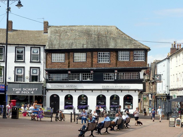
| Nos. 5 and 6, Greenmarket | 1210129 | I | C14th | Castle | Includes the Guildhall Museum. |
| Nos. 5-29, Chiswick Street | 1292594 | II | Castle | ||
| Nos. 5-33, Spencer Street | 1297402 | II | Castle | ||
| Nos. 6 and 7, Portland Square | 1196936 | II | Castle | ||
| No. 6, Paternoster Row | 1218268 | II | Castle | Paternoster Row | |
| Nos. 6-12, Castle Street | 1196990 | II | Castle | Castle Street | |
| Nos. 6-20, Hartington Place | 1210150 | II | Castle | ||
| Nos. 6-26, Spencer Street | 1291832 | II | Castle | ||
| No. 60, Scotch Street | 1291847 | II | Castle | ||
| No. 61, Warwick Road | 1197143 | II | Castle | Warwick Road | |
| Nos. 63-69, Warwick Road | 1197144 | II | Castle | Warwick Road | |
| No. 7, Paternoster Row | 1196935 | II | Castle | Paternoster Row | |
| No. 70, Scotch Street | 1196913 | II | Castle | ||
| No. 71, Warwick Road | 1218882 | II | Castle | Warwick Road | |
| No. 73, Warwick Road | 1197145 | II | Castle | Warwick Road | |
| Nos. 75-81, Warwick Road | 1218885 | II | Castle | Warwick Road | |
| Nos. 8 and 9, Portland Square | 1292013 | II | Castle | ||
| No. 8, Lowther Street | 1218057 | II | 1863 | Castle | Lowther Street |
| Nos. 85-93, Warwick Road | 1291754 | II | Castle | Warwick Road | |
| No. 9, Earl Street | 1196973 | II | 1830s | Castle | Earl Street |
| No. 9, Fisher Street | 1196950 | II | Castle | Fisher Street | |
| No. 92, Newtown Road | 1218220 | II | Castle | ||
| Nos. 99, 101 and 103, Warwick Road | 1218891 | II | 1830s | Castle | Warwick Road |
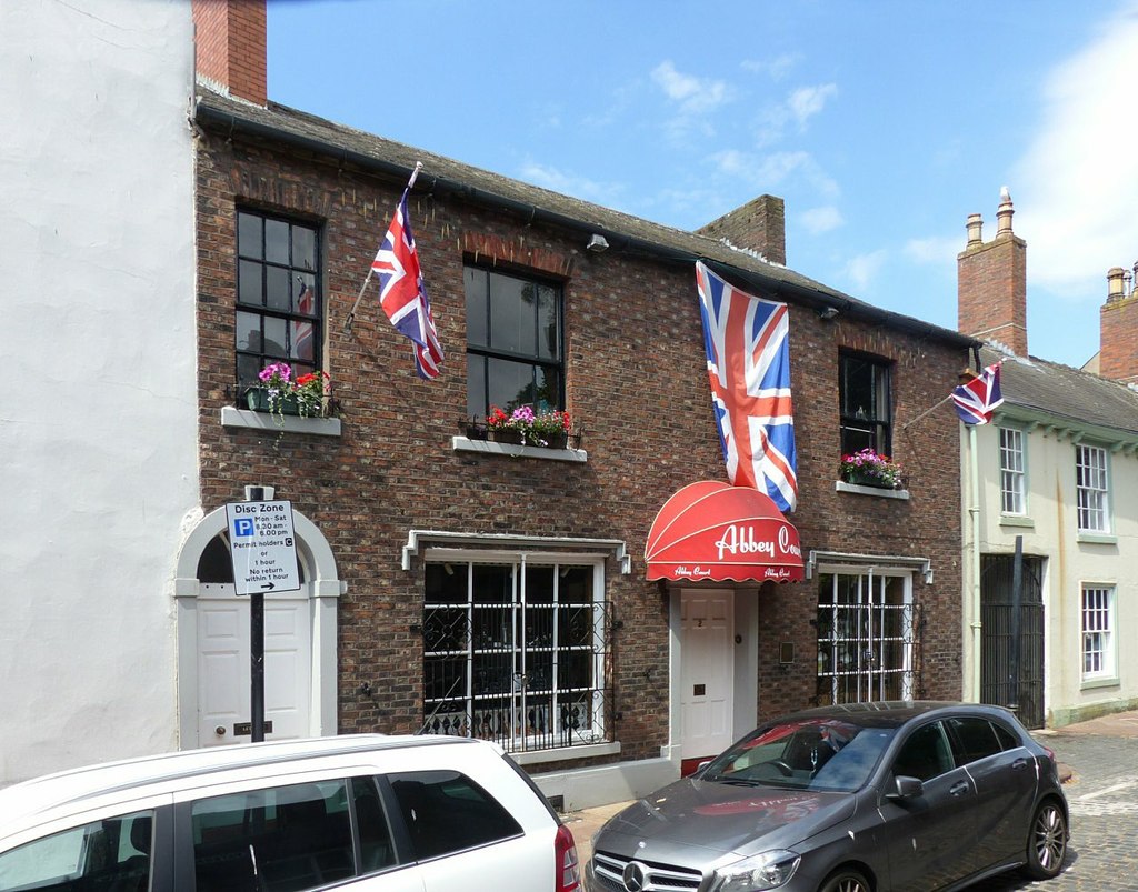
| Abbey Court | 1196934 | II | C19th | Castle | Paternoster Row, Nos 1 & 2. |
| Abbey Gate and Gatehouse | 1208514 | I | 1528 | Castle | Abbey Street |
| Arkle House | 1297406 | II | 1874 | Castle | Lonsdale Street |
| Barclays Bank | 1297375 | II | 1875 | Castle | Bank Street |
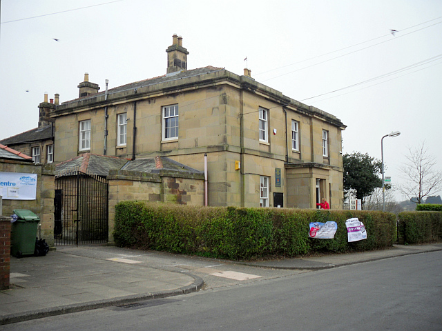
| Bishops Registry | 1197012 | II* | 1699 | Castle | Cathedral Precinct |
| Bridge over Outer Moat | 1297365 | I | C18th | Castle | Carlisle Castle |
| Caladonian Mill | 1292994 | II | 1840s | Castle | Bachouse Walk |
| Captains Tower and Inner Bailey Walls | 1297368 | I | C12th | Castle | Carlisle Castle |
| Carlisle Public Markets | 1297380 | II | 1889 | Castle | Market St, Fisher St, Scotch St. |
| Cathedral Church of the Holy and Undivided Trinity | 1208430 | I | C12th | Castle | |
| Cavendish House | 1297275 | II | 1832 | Castle | Warwick Road |
| Chatsworth House | 1297385 | II | 1870 | Castle | Chatsworth Square |
| Church House | 1197150 | II | C19th | Castle | West Walls |
| Church of Our Lady and St Joseph | 1197148 | II | 1893 | Castle | Warwick Road |
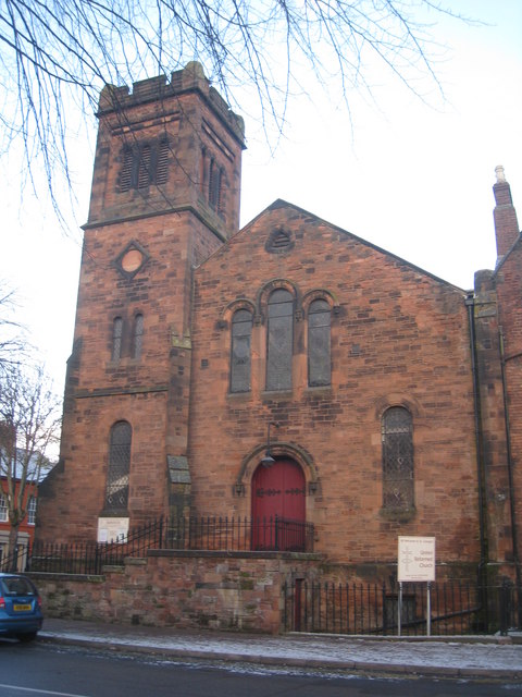
| Church of St Cuthbert with St Mary | 1218565 | II* | 1778 | Castle | On an ancient site. |
| Church of St George and attached manse | 1421406 | II | 1863 | Castle | Warwick Road |
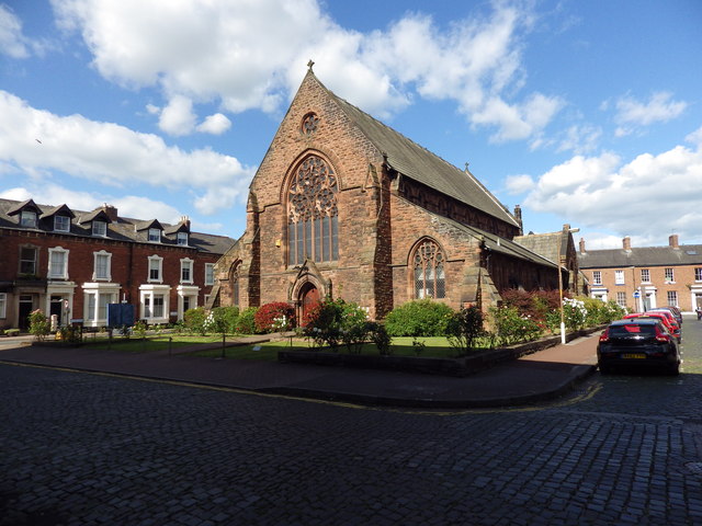
| Church of St Paul | 1217889 | II | 1870 | Castle | Lonsdale Street. Now Elim Community Church. |
| City Boundary Stone at NY 3993 5645 | 1197149 | II | 1830s | Castle | Bitts Park |
| Clydesdale Bank | 1297357 | II | 1878 | Castle | Bank Street |
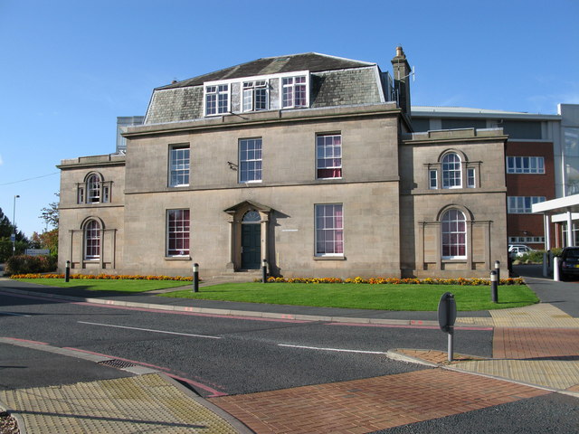
| Coledale Hall | 1196932 | II* | 1810 | Castle | Newtown Road |
| Congregational Church | 1196929 | II* | 1843 | Castle | Lowther Street |
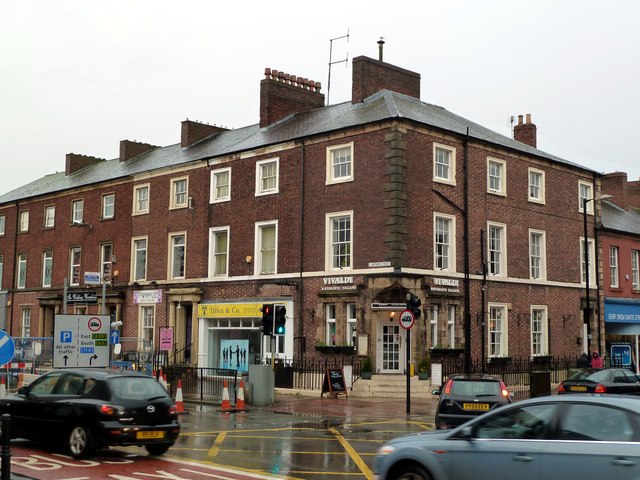
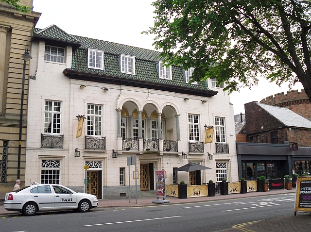
| County Hotel | 1208782 | II | 1896 | Castle | Botchergate |
| County Hotel (Part) The Caledonian Public House | 1208808 | II | c.1852 | Castle | Botchergate. |
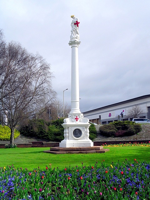
| Creighton Memorial | 1408781 | II | 1898 | Castle | Hardwicke Circus |
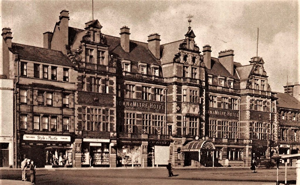
| Crown and Mitre Hotel | 1297351 | II | 1905 | Castle | English Street |
| Crozier Lodge, Cumberland Infirmary | 1297371 | II | 1820s | Castle | Newtown Road |
| Cumberland Infirmary | 1218237 | II* | 1832 | Castle | Old Infirmary building |
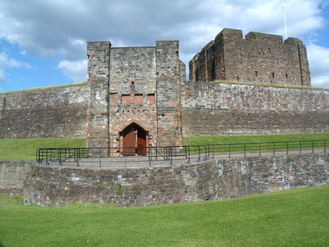
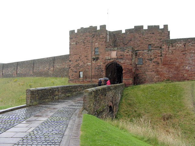
| De Irebys Tower and Outer Bailey Wall | 1197000 | I | C13th | Castle | Carlisle Castle |
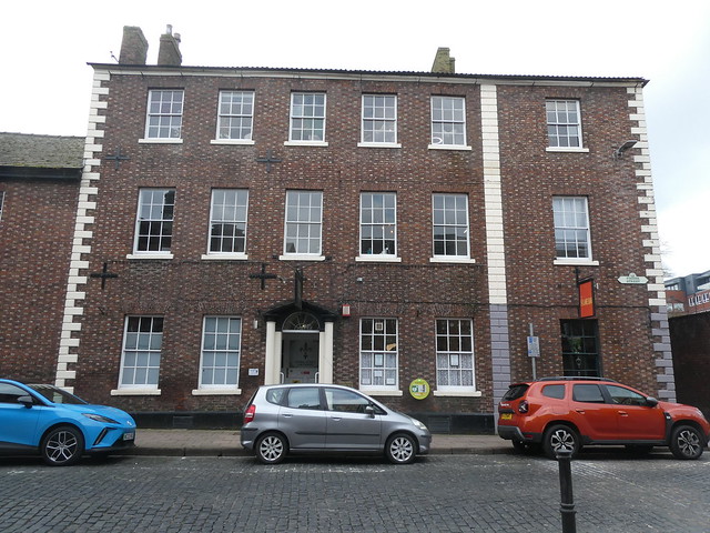
| Devonshire Chambers | 1209682 | II | 1860s | Castle | Devonshire Street |
| Diocesan Church Centre | 1218930 | II | 1832 | Castle | West Walls. Now St George's URC Church |
| Dispensary | 1196958 | II | 1857 | Castle | Chapel Street |
| Eaglesfield House | 1196982 | II | C17th | Castle | Abbey Street |
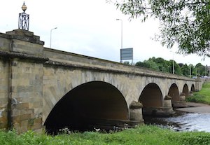
| Eden Bridge | 1297364 | I | 1815 | Castle | Bridge over the River Eden. |
| Entrance Gate Piers and Wall to East of Cumberland Infirmary | 1196956 | II | 1930s | Castle | Infirmary Street |
| Ex Servicemen's Club | 1197138 | II | 1850s | Castle | Victoria Place |
| Former Priory Wall and Deanery Garden Wall | 1197014 | II | C12th | Castle | Dean Tait's Lane |
| Fragment of North City Walls Adjoining South East Angle | 1197001 | I | C12th | Castle | Adjoins Carlisle Castle. |
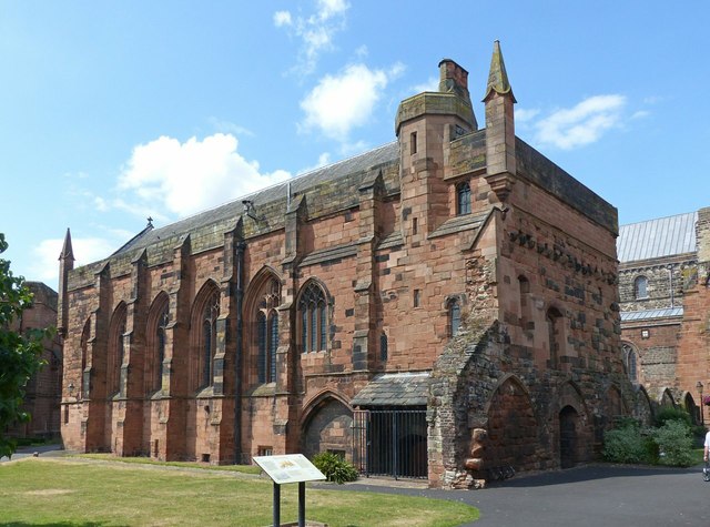
| Fratry of Former Priory of St Mary | 1208468 | I | C15th | Castle | Carlisle Cathedral |
| Gates and Lamp Bracket to East of Church of St Cuthbert with St Mary | 1196910 | II | c.1825 | Castle | St Cuthbert's Lane |
| Herbert Atkinson House | 1196977 | II | C18th | Castle | Abbey Street |
| Inner Bailey Keep | 1208315 | I | C12th | Castle | Carlisle Castle |
| Inner Bailey Magazine | 1197006 | II | 1827 | Castle | Carlisle Castle |
| Inner Bailey Militia Store | 1293187 | II | 1881 | Castle | Carlisle Castle |
| Inner Bailey Palace Range Including Part of Queen Mary's Tower | 1197007 | I | C14th | Castle | Carlisle Castle |
| Larch House | 1208921 | II | 1860s | Castle | Brunswick Street |
| Liberal Club | 1297408 | II | 1830s | Castle | Lowther Street |
| Lloyds Bank | 1292237 | II | c.1853 | Castle | Lowther Street |
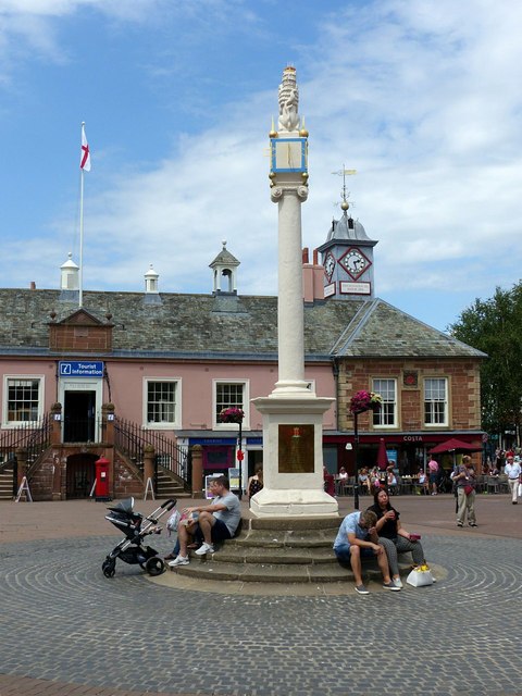
| Market Cross | 1297369 | I | 1682 | Castle | On the site of a previous medieval cross. |
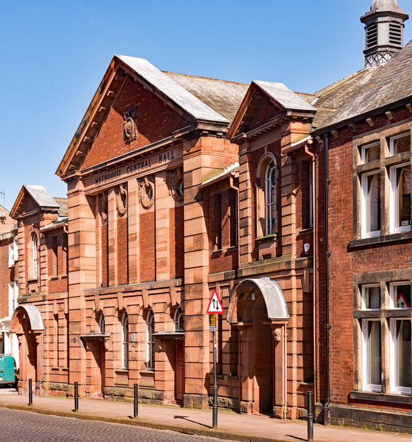
| Methodist Central Hall | 1392920 | II | 1922 | Castle | Fisher Street |
| Midland Bank | 1297387 | II | 1867 | Castle | Court Square |
| Midland Bank, Including Railings | 1196938 | II | 1849 | Castle | English Street |
| Nisi Prius Courthouse, Associated Offices and Gate Arch | 1196940 | I | 1542 | Castle | Carlisle Citadel (part of) |
| No. 1 the Abbey | 1208557 | II | C17th | Castle | Cathedral precinct |
| No. 10 Including Railings | 1196937 | II | 1870s | Castle | Portland Square |
| Nos. 14 and 16 with Gate Piers to Front | 1196962 | II | 1860s | Castle | Chiswick Street |
| No. 2, the Abbey | 1197013 | II* | C17th | Castle | Cathedral precinct |
| No. 22 Including Railings at Front | 1196928 | II | 1892 | Castle | Lowther Street |
| No. 3 and Adjacent Outbuildings | 1218264 | II | C18th | Castle | Paternoster Row |
| No. 32 and Railings to Front | 1293020 | II* | 1817 | Castle | Abbey Street |
| No. 4, the Abbey | 1297329 | II | 1863 | Castle | Cathedral precinct |
| No. 1 Including Intergral Shop | 1196989 | II | 1890s | Castle | Castle Street |
| Nos 103, 105 and Howard Arms Public House, Lowther Street | 1218034 | II | C18th | Castle | Lowther Street |
| Nos. 11-14 Including Railings to Nos 13 and 14 | 1196902 | II | 1870s | Castle | Portland Square |
| Nos. 24 and 26 Including Railings to Front | 1217914 | II | 1830s | Castle | Lowther Street |
| Nos. 26, 28 and 30 and Railings to Front | 1355058 | II* | 1823 | Castle | Castle Street |
| Nos. 3 and 6 The Abbey | 1293105 | II* | C17th | Castle | Cathedral precinct |
| Nos. 30-40 Including Railings to Front | 1292188 | II | 1824 | Castle | Lowther Street |
| Nos. 37 and 39 Including Overthrow and Lamp Bracket | 1218009 | II | 1830s | Castle | Lowther Street |
| Nos. 95 and 97 Including Railings to Front | 1197146 | II | 1840s | Castle | Warwick Road |
| Numbers 10-22 Incorporating City Walls | 1297278 | I | C19th | Castle | West Walls |
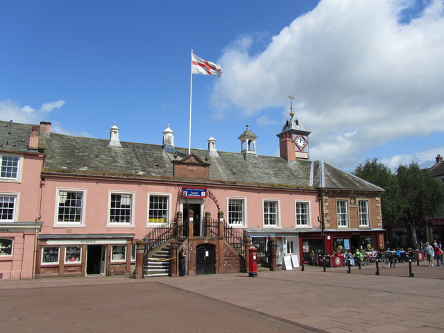
| Old Town Hall | 1218104 | I | 1669 | Castle | Market Place. |
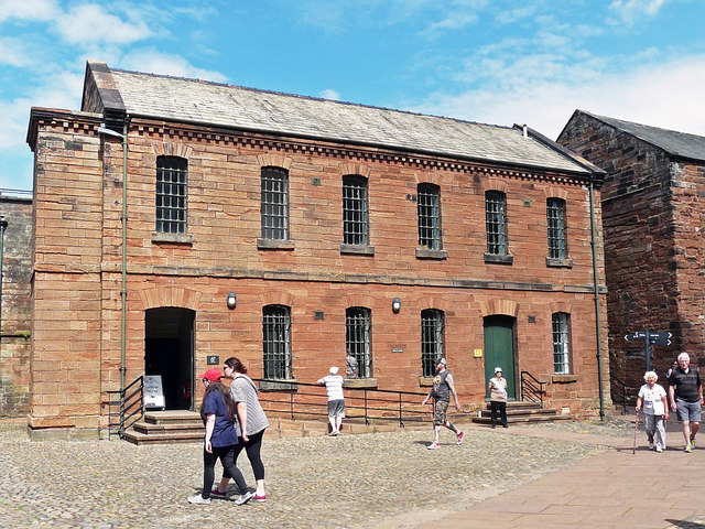
| Outer Bailey Alma Block | 1297366 | II | 1932 | Castle | Carlisle Castle |
| Outer Bailey Arroyo Block, Gym and Regimental Association Club | 1297367 | II | 1804 | Castle | Carlisle Castle |
| Outer Bailey Gallipoli Block | 1197004 | II | 1829 | Castle | Carlisle Castle |
| Outer Bailey Garrison Cells and Custodian's Office | 1293243 | II | 1832 | Castle | Carlisle Castle |
| Outer Bailey Half Moon Battery, Flanking Wall and Bridge | 1197005 | I | 1542 | Castle | Carlisle Castle |
| Outer Bailey Officers' Mess | 1208359 | II | 1876 | Castle | Carlisle Castle |
| Outer Bailey Ypres Block | 1208301 | II | 1837 | Castle | Carlisle Castle |
| Outer Bailey: Arnhem Block | 1197003 | II | 1805 | Castle | Carlisle Castle |
| Piers, Wall and Railings to South of the Sands Sports Centre | 1297370 | II | 1895 | Castle | Newmarket Road |
| Railings and Gates at East End of Cathedral | 1197010 | II | 1930 | Castle | |
| Red Gables | 1196959 | II | 1885 | Castle | Chatsworth Square |
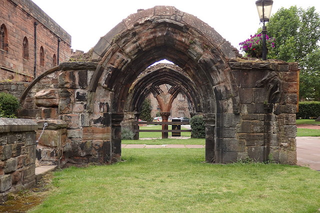
| Ruins of Dormitory of Former Priory of St Mary | 1197011 | I | C13th | Castle | Carlisle Cathedral |
| St Cuthbert's Vicarage and Associated Railings | 1297279 | II | 1832 | Castle | West Walls |
| St Gabriels Court | 1389127 | II | 1896 | Castle | Howard Place |
| Statue of Earl of Lonsdale | 1297404 | II | 1846 | Castle | The Crescent |
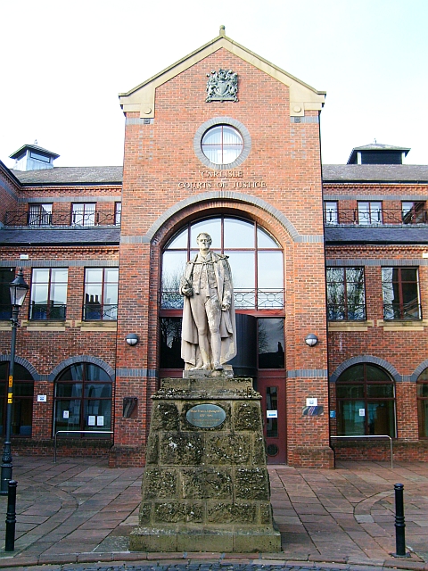
| Statue of Francis Aglionby | 1417583 | II | 1843 | Castle | Earl Street |
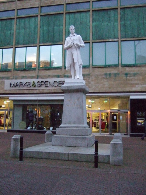
| Statue of James Steel | 1196942 | II | 1859 | Castle | English Street |
| Statue of Queen Victoria | 1218785 | II | 1902 | Castle | Bitts Park |
| The Andalusian | 1291729 | II | 1932 | Castle | Warwick Road |
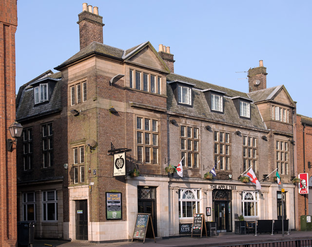
| The Apple Tree | 1119685 | II | 1925 | Castle | Lowther Street |
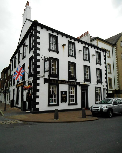
| The Boardroom Public House | 1196992 | II | C18th | Castle | Castle Street |
| The County Bar | 1208798 | II | 1868 | Castle | Botchergate |
| The Deanery and Prior's Tower | 1208577 | I | C15th | Castle | Cathedral precinct |
| The Pheasant Inn | 1209553 | II | C18th | Castle | Church Street |
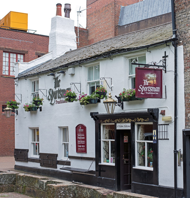
| The Sportsman Inn | 1210153 | II | C18th | Castle | Heads Lane |
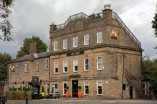
| The Turf Inn | 1218199 | II | 1840 | Castle | Newark Road. Grandstand hotel for the racecourse |
| Theakston's Carlisle Brewery | 1208869 | II | C19th | Castle | Bridge Street |
| Tithe Barn | 1218932 | I | C15th | Castle | Now church hall, St Cuthbert's |
| Tollund House | 1297352 | II | C19th | Castle | Abbey Street |
| Trustee Savings Bank and Attached Railings | 1196930 | II* | 1840 | Castle | Lowther Street. Now Lloyds Bank. |
| Tullie House and Extensions | 1297353 | I | 1689 | Castle | Abbey Street |
| Wall and Railings Around Central Gardens | 1291976 | II | 1870 | Castle | Portland Square |
| Wall, Gates and Railings in Front of Tullie House | 1196978 | I | ?C17th | Castle | Tullie House, Abbey Street |
| Wall, Railings and Gates Around Central Gardens | 1297386 | II | 1870s | Castle | Chatsworth Square |
| Wall, Railings and Piers to West of the Sands Sports Centre | 1292909 | II | 1895 | Castle | Bridge Water Road |
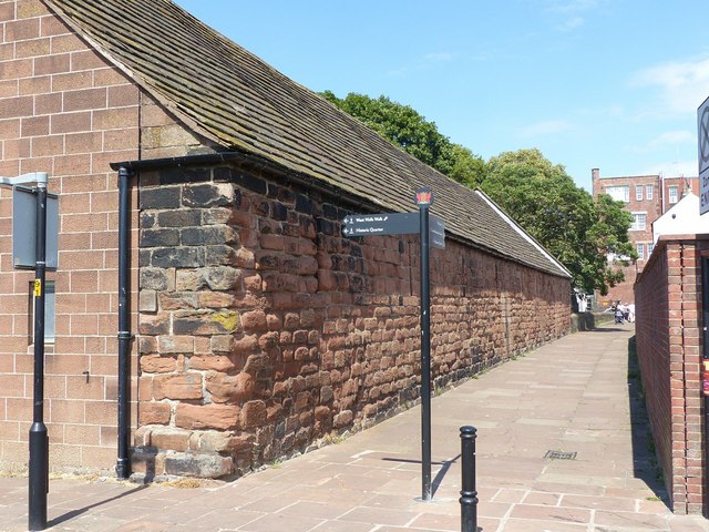
| West City Walls | 1197151 | I | C12th | Castle | |
| West City Walls and Tile Tower Adjoining at South West | 1197002 | I | C12th | Castle | |
| No. 2, Etterby Close | 1245330 | II | 1830s | Belah | |
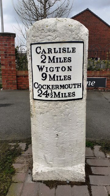
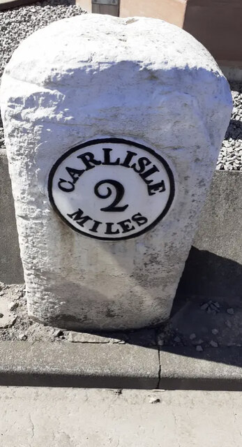
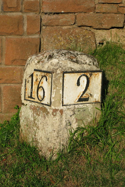
| Milestone East of Number 325 | 1196921 | II | 1820s | Belah | Kingstown Road |
| St Ann's | 1196944 | II | c.1806 | Belah | Etterby Scaur |
| The Redfern Public House | 1380323 | II | 1940 | Belah | Etterby |
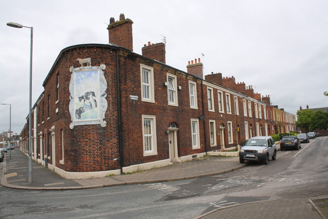
| No. 18, Wood Street | 1197155 | II | C18th | Botcherby | |
| No. 20, Wood Street | 1197156 | II | C17th | Botcherby | |
| No. 22, Wood Street | 1219033 | II | C18th | Botcherby | |
| Nos. 32 and 34, Wood Street | 1291649 | II | C19th | Botcherby | |
| Nos. 35-43, Victoria Road | 1197140 | II | 1830s | Botcherby | |
| Ashleigh House, Railings and Adjoining Garage | 1297283 | II | C19th | Botcherby | Wood Street |
| Barn to North West of Durranhill Lodge | 1292505 | II | C18th | Botcherby | Durranhill Road |
| Botcherby House | 1218982 | II | C18th | Botcherby | Wood Street |
| Botcherby War Memorial | 1458474 | II | 1921 | Botcherby | Victoria Road / Warwick Road |
| Bramerton and Associated Railings | 1219036 | II | C18th | Botcherby | Wood Street |
| Bramerton Lodge and Associated Railings | 1219051 | II | C19th | Botcherby | Wood Street |
| Church Farmhouse, Associated Railings and Adjoining Barn | 1197115 | II | C18th | Botcherby | Wood Street |
| Church of St Andrew | 1413631 | II | 1890 | Botcherby | Wood Street |
| Durranhill House | 1292498 | II | c.1811 | Botcherby | Durranhill Road |
| Durranhill Lodge | 1297349 | II | 1870 | Botcherby | Durranhill Road |
| Holme Farmhouse | 1297281 | II | C18th | Botcherby | Wood Street |
| Magpie Inn Public House | 1404909 | II | 1933 | Botcherby | Victoria Road |
| Mayfield, and Associated Railings | 1197154 | II | C19th | Botcherby | Wood Street |
| Norman House | 1219005 | II | 1700 | Botcherby | Wood Street |
| Orchard House | 1197116 | II | C18th | Botcherby | Wood Street |
| The Beeches and Adjoining Former Barn or Stable | 1219024 | II | 1767 | Botcherby | Wood Street |
| The Cottage and Adjoining Former Stable | 1219014 | II | C18th | Botcherby | Wood Street |
| The Grange and Associated Railings, Stable Croft (16) and Adjoining Barn | 1297282 | II | C19th | Botcherby | Wood Street |
| Nos. 1-11, Woodrouffe Terrace | 1197117 | II | 1850s | Currock | off St Nicholas Street |
| No. 38, St Nicholas Street | 1218637 | II | C19th | Currock | St Nicholas Street |
| Nos. 5-61, St Nicholas Street | 1196911 | II | 1840s | Currock | St Nicholas Street |
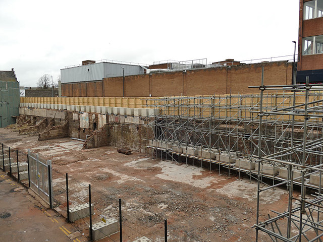
| 1197141 | II | C12th | Currock | West Walls. Hotel demolished 2020. | |
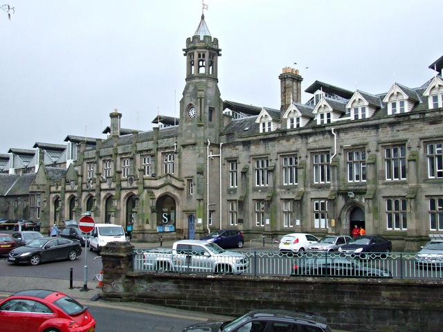
| Citadel Station | 1196969 | II* | 1847 | Currock | Carlisle Railway Station |
| Crown Court, Adjoining Offices and Gate Arch | 1196939 | I | 1542 | Currock | Carlisle Citadel (part of) |
| Cumberland Inn | 1380211 | II | 1930 | Currock | Botchergate |
| Currock House Community Centre | 1196923 | II | C19th | Currock | Lediard Avenue |
| Detached West Wall of Citadel Station | 1209674 | II | 1880 | Currock | Court Square |
| Gaol Wall, West of Crown Court | 1196983 | II | 1827 | Currock | Borough Street |
| Hospital Wing of County Gaol and Gaol Wall | 1196941 | II | 1827 | Currock | English Street |
| No 4 Gasholder, Carlisle Gas Works | 1196909 | II | 1879 | Currock | Rome Street |
| The Cumbrian Hotel | 1209676 | II | 1852 | Currock | Court Square. Now the Station Hotel. |
| The Golden Lion Public House | 1291894 | II | C19th | Currock | Botchergate / St Nicholas Street. Now Gallagher's Bar. |
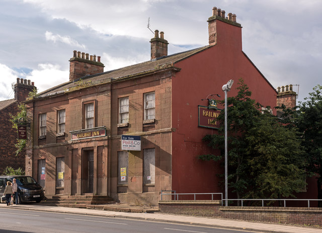
| The Railway Inn | 1196925 | II | 1837 | Currock | London Road. Former pub. |
| Turkish Suite, the Pools | 1393755 | II | 1909 | Currock | James Street |
| Nos. 2-22, Bridge Terrace | 1196987 | II | Denton Holme | ||
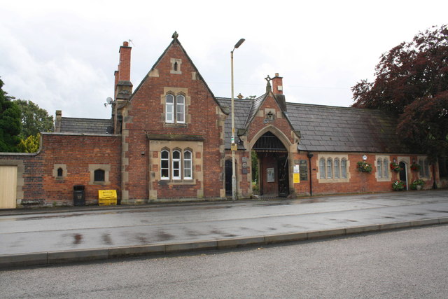
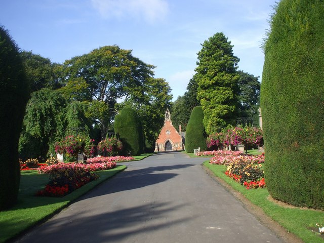
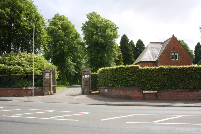
| Carlisle Cemetery West Lodge | 1209679 | II | 1856 | Denton Holme | Carlisle Cemetery |
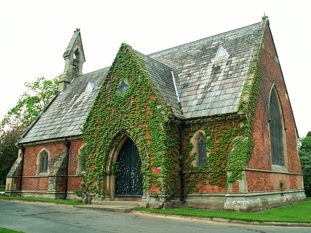
| Carlisle Cemetery Chapel | 1196907 | II | 1856 | Denton Holme | Carlisle Cemetery |
| Church of St James | 1297399 | II | 1867 | Denton Holme | Longsowerby |
| Dixons Chimney at Shaddon Mill | 1196919 | II* | 1836 | Denton Holme | Shaddongate / Junction Street |
| Former Holme Head Coffee Tavern and Reading Room | 1196933 | II | 1881 | Denton Holme | North Street |
| Gates and Gate Piers to East of West Lodge, Carlisle Cemetery | 1196970 | II | 1856 | Denton Holme | Dalston Road |
| Holme Head House | 1197008 | II | C19th | Denton Holme | nr. Denton Mill Close |
| Kingdom Hall of the Jehovah's Witnesses | 1297384 | II | 1860 | Denton Holme | Charlotte Street |
| Milbourne Arms Public House | 1196931 | II | 1853 | Denton Holme | Milbourne Street |
| Monument to Daniel Clark and Associated Railings | 1297397 | II | 1880 | Denton Holme | Richardson Street |
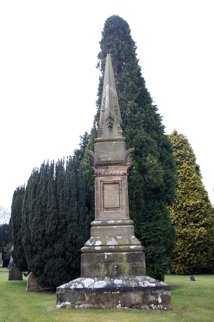
| Monument to Peter Nicholson, North West of Cemetery Chapel | 1218406 | II* | 1856 | Denton Holme | Carlisle Cemetery |
| Mortuary Chapel (Disused) | 1218426 | II | 1856 | Denton Holme | Richardson Street |
| No. 153 and Carlisle Cemetery Office | 1196908 | II | 1856 | Denton Holme | Richardson Street |
| Offices of North West Water Limited | 1208371 | II | 1853 | Denton Holme | Bridge Terrace |
| Offices of North West Water Ltd (Former Factory) | 1208391 | II | C19th | Denton Holme | Nr. Denton Mill Close |
| Shaddon Mill | 1297383 | II* | 1836 | Denton Holme | Junction Street |
| The Mill at Holme Head Works | 1197009 | II | 1865 | Denton Holme | Denton Mill Lane |
| Tuethur | 1218603 | II | 1923 | Denton Holme | St James Road |
| Boundary Stone Outside Number 431 (431 Not Included) | 1217855 | II | C19th | Harraby | London Road |
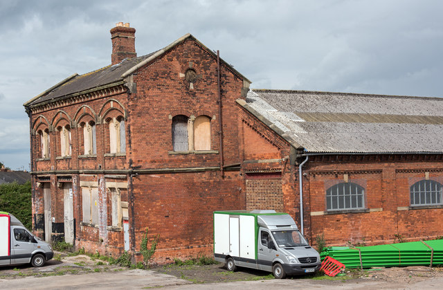
| London Road NER Goods Station | 1430159 | II | 1881 | Harraby | London Road |
| Milestone Outside Number 405 | 1196926 | II | C19th | Harraby | London Road |
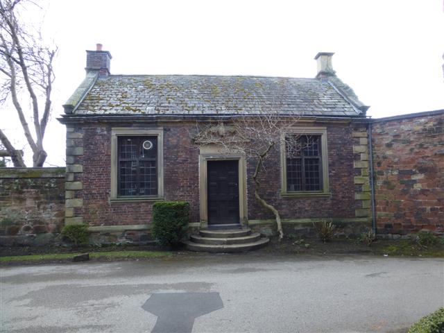
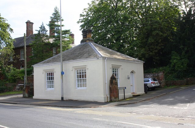
| The Lodge | 1217845 | II | 1830 | Harraby | London Road. Toll cottage. |
| Horse and Farrier Public House | 1218944 | II | 1928 | Morton | Wigton Road. By Harry Redfern. |
| Morton Community Centre | 1291709 | II | C19th | Morton | Wigton Road |
| Wall and Railings in Front of Horse and Farrier Public House | 1197152 | II | 1928 | Morton | Wigton Road |
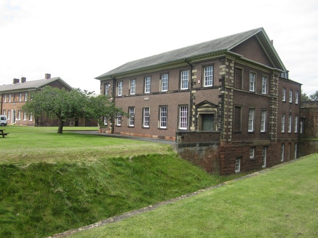
| Blencathra Building | 1210121 | II | 1864 | St Aidans | Fusehill Street |
| Christ Church War Memorial, Carlisle | 1458500 | II | 1921 | St Aidans | Warwick Road |
| Church of St Aidan | 1218914 | II | 1902 | St Aidans | Warwick Road |
| Skiddaw Building | 1196953 | II | 1864 | St Aidans | Fusehill Street |
| St Aidan's Church Hall | 1297277 | II | 1901 | St Aidans | Warwick Road |
| St Nicholas Arms Public House | 1297405 | II | C19th | St Aidans | London Road |
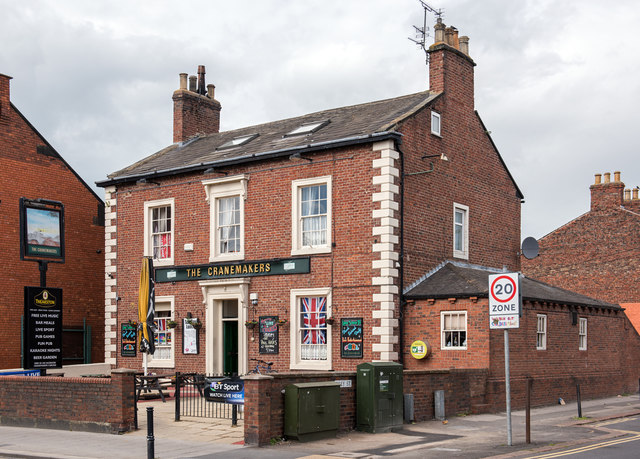
| The Cranemaker Public House | 1196924 | II | 1830s | St Aidans | London Road |
| Nos. 1, 2 and 3, Etterby Scaur | 1196943 | II | 1850s | Stanwix Urban | |
| Nos. 1,2 and 3, Stanwix Bank | 1218736 | II | 1840s | Stanwix Urban | |
| Nos. 1-8, Eden Mount | 1209736 | II | 1840s | Stanwix Urban | |
| Nos. 1-9, Devonshire Terrace | 1196971 | II | 1832 | Stanwix Urban | |
| No. 10, Etterby Street | 1196945 | II | 1830s | Stanwix Urban | |
| No. 12, Etterby Street | 1209908 | II | 1830s | Stanwix Urban | |
| Nos. 14 and 16, Etterby Street | 1196946 | II | 1830s | Stanwix Urban | |
| Nos. 14, 16 and 18, Kells Place | 1196920 | II | C18th | Stanwix Urban | |
| Nos. 18 and 20, Etterby Street | 1209959 | II | 1830s | Stanwix Urban | |
| Nos. 22 and 24, Etterby Street | 1196947 | II | 1830s | Stanwix Urban | |
| Nos. 26-36, Etterby Street | 1209960 | II | 1830s | Stanwix Urban | |
| Nos. 28-34, Eden Street | 1292475 | II | 1850s | Stanwix Urban | |
| Nos. 38, 40 and 42, Etterby Street | 1297376 | II | 1830s | Stanwix Urban | |
| Nos. 38-48, Scotland Road | 1297401 | II | 1830s | Stanwix Urban | |
| Nos. 43-51, Scotland Road | 1218693 | II | 1860s | Stanwix Urban | |
| Nos. 44-50, Etterby Street | 1209966 | II | 1830s | Stanwix Urban | |
| Nos. 50 and 52, Scotland Road | 1196914 | II | C19th | Stanwix Urban | |
| No. 52, Etterby Street | 1196948 | II | 1830s | Stanwix Urban | |
| Nos. 54-60, Etterby Street | 1209971 | II | 1830s | Stanwix Urban | |
| Nos. 6 and 8, Etterby Street | 1209903 | II | 1840s | Stanwix Urban | |
| Nos. 60-70, Etterby Street | 1297377 | II | 1830s | Stanwix Urban | |
| Nos. 72-80, Etterby Street | 1292394 | II | 1840s | Stanwix Urban | |
| Nos. 82 and 84, Etterby Street | 1196949 | II | 1840s | Stanwix Urban | |
| No. 9, Eden Mount | 1196974 | II | 1840s | Stanwix Urban | |
| Cavendish Hill | 1208990 | II | c.1850 | Stanwix Urban | Cavendish Terrace |
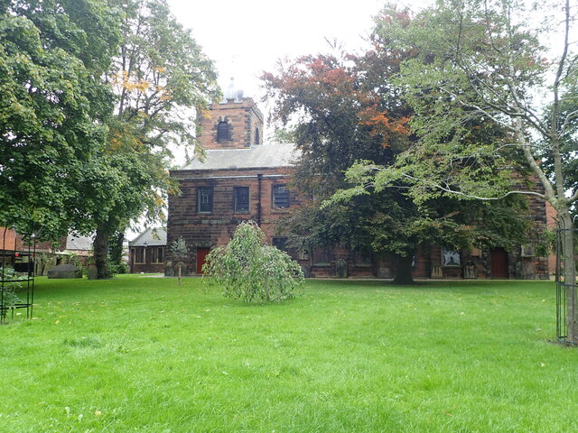
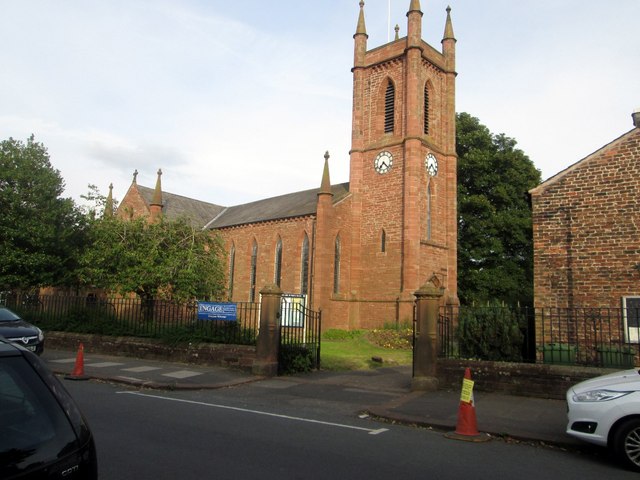
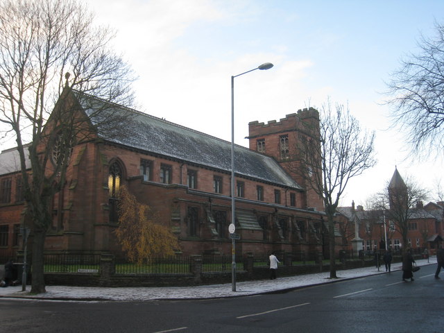
| Church of St Michael | 1209583 | II | 1843 | Stanwix Urban | Curch Street |
| Cumberland and Westmorland Joint Counties’ War Memorial | 1291971 | II* | 1922 | Stanwix Urban | Rickerby Park |
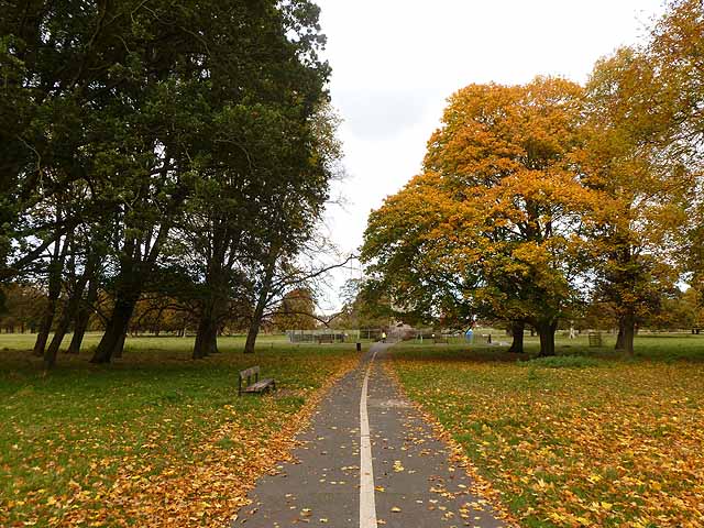
| Rickerby Park, Carlisle | 1448365 | II | 1922 | Stanwix Urban | Listed Park and Garden |
| Cumbria College of Art and Design Homeacres | 1208815 | II | 1840s | Stanwix Urban | Brampton Road |
| Cumbria College of Art and Design the Cottage and Homeacres Cottage | 1196985 | II | 1854 | Stanwix Urban | Brampton Road |
| Gates, Piers and Overthrow at Entrance to the Old Vicarage | 1292561 | II | C19th | Stanwix Urban | Church Street |
| Gateway, Wall and Lamp Brackets at South Entrance to Stanwix House | 1292935 | II | C19th | Stanwix Urban | Brampton Road |
| Hyssop Holme Well | 1196993 | II | 1817 | Stanwix Urban | Cavendish Terrace |
| Little Bank | 1196984 | II | c.1813 | Stanwix Urban | Brampton Road |
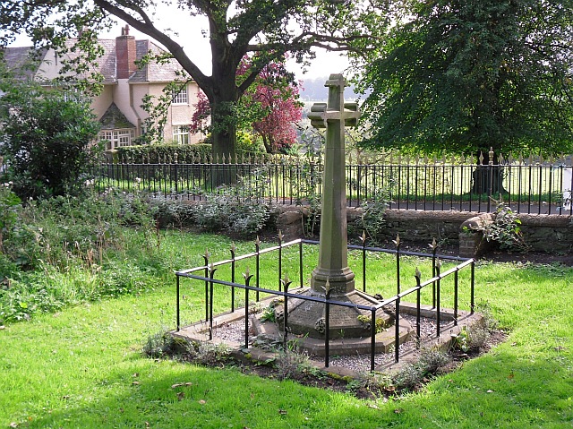
| Monument to Dean Tait's Children to South of Church of St Michael | 1196966 | II | 1856 | Stanwix Urban | Stanwix, Church Street |
| Monument to George Head Head to South West of Church of St Michael | 1209595 | II | 1876 | Stanwix Urban | Stanwix, Church Street |
| Mulcaster House | 1196986 | II* | C18th | Stanwix Urban | Brampton Road |
| Old Farm Pottery | 1196922 | II | C19 | Stanwix Urban | Knowefield |
| Stanwix House | 1196968 | II | C19th | Stanwix Urban | Church Street |
| The Old Vicarage | 1196967 | II | 1809 | Stanwix Urban | Church Street |
| Petteril Bank | 1297373 | II* | 1829 | Upperby | Now Lady Gillfords House. |
| Milestone Outside Suttle House | 1197153 | II | C19th | Yewdale | Wigton Road |
| Morton Cottage | 1297280 | II | C18th | Yewdale | Wigton Road |
| Suttle House | 1218967 | II | C18th | Yewdale | Wigton Road |
| Dalston Road Cemetery | 1001613 | II | 1855 | Denton Holme | Listed Park and Garden |
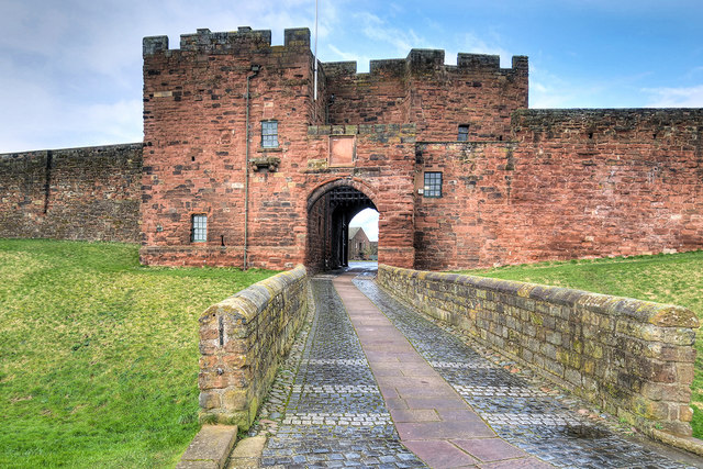
| Carlisle Castle; medieval tower keep castle, two lengths of city wall, a 16th century battery, and part of an earlier Roman fort known as Luguvalium | 1014579 | n/a | Castle | Scheduled Monument | |
| Carlisle Cathedral precinct | 1007074 | n/a | Castle | Scheduled Monument. Site of Roman fort. | |
| Area of Roman and medieval towns, bounded by Annetwell Street, Abbey Street, Castle Street and Paternoster Row | 1007075 | n/a | Castle | Scheduled Monument | |
| City wall, NE side | 1007123 | n/a | C12th | Castle | Scheduled Monument |
| Town wall, section on West Walls | 1007149 | n/a | C12th | Castle | Scheduled Monument |
| Roman and medieval town area bounded by Heads Lane West Wall and Blackfriars Street | 1007275 | n/a | Castle | Scheduled Monument | |
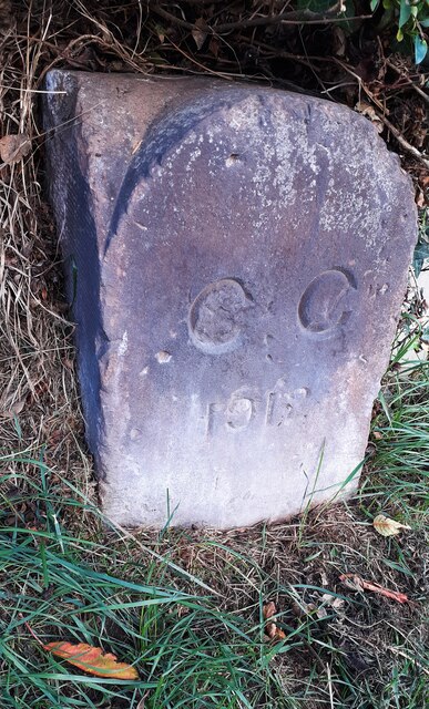
| Old Carlisle City Boundary Stone | not listed | n/a | 1912 | Stanwix Urban | Whiteclosegate |
| Old Carlisle City Boundary Stone | not listed | n/a | 1912 | Harraby | Harraby |
| Friends Burying Ground (now site of Meeting House) | not listed | n/a | C18th | Castle | Fisher Street |
| The Kings Head | not listed | n/a | ? | Castle | Fisher Street. On the site of a much earlier hostelry. |
| No. 15, Fisher Street | not listed | n/a | 1879 | Castle | Fisher Street. Former Town Clerks Office |
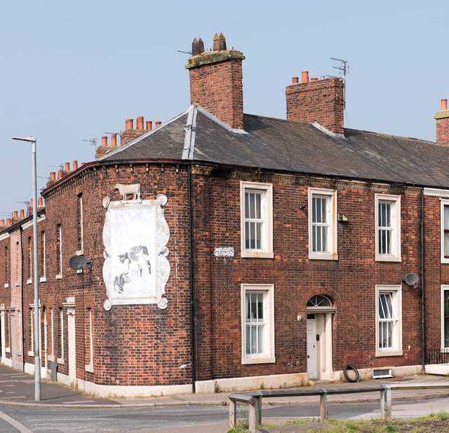
| Former White Ox, St Nicholas Street | spans 2 listings | II | c.1852 | Currock | St Nicholas Street / Woodrouffe Terrace |
| Church of St John the Evangelist | not listed | n/a | 1867 | Harraby | London Road |
| First World War Memorial | not listed | n/a | 1920 | Denton Holme | Carlisle Cemetery |
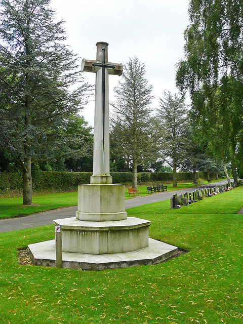
| Cross of Sacrifice | not listed | n/a | c.1920 | Denton Holme | Carlisle Cemetery |
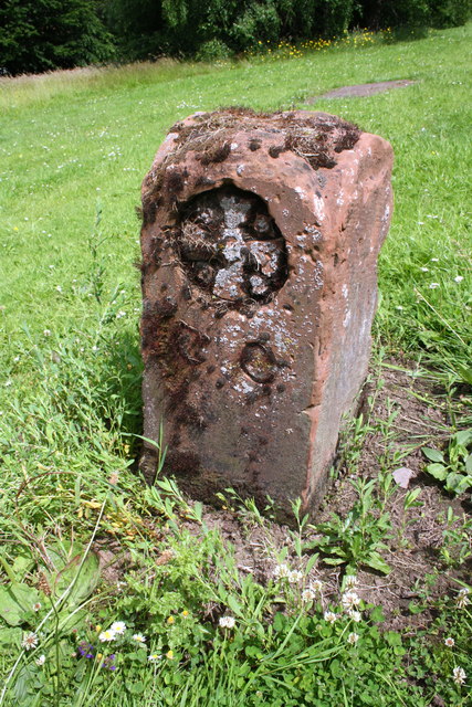
| Boundary Stone | not listed | n/a | C19th | Denton Holme | Dalston Road |
| Waverley Viaduct, West of the Former Electricity Works | 1291680 | II | 1861 | Willow Holme | Partly in Kingmoor CP |
| Holme Head Conservation Area | - | n/a | Conservation Area | ||
| Victoria Road Conservation Area, Botcherby | - | n/a | Conservation Area | ||
| Botchergate Conservation Area | - | n/a | Conservation Area | ||
| Stanwix Conservation Area | - | n/a | Conservation Area | ||
| Carlisle-Settle Railway Conservation Area | - | n/a | Conservation Area | ||
| Carlisle City Centre Conservation Area | - | n/a | Conservation Area | ||
| Chatsworth Square and Portland Square Conservation Area | - | n/a | Conservation Area |
Primary source: the National Heritage List for England - NHLE is the register of nationally protected historic buildings and sites in England, including listed buildings, scheduled monuments, protected wrecks, registered parks and gardens, and battlefields. The list is maintained by Historic England. Check NHLE for updates and new entries. Secondary sources: British Listed Buildings.
Co-Curate Page
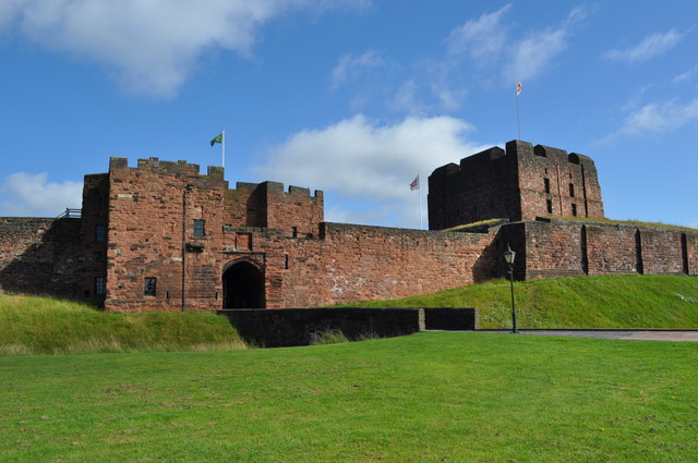
Carlisle Castle
- Overview About Carlisle Castle Map Street View Carlisle Castle is built on the site of a Roman fort (known as Luguvalium). Construction of a motte and bailey castle began in …
Co-Curate Page
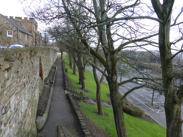
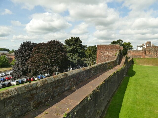
City Walls
- The city walls in Carlisle were built in the 12th century. The walls enclosed the city south of the castle, which was built in 1112 AD. The city walls included …
Co-Curate Page
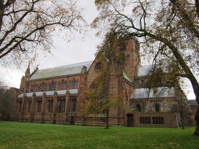
Carlisle Cathedral
- Overview About Carlisle Cathedral Map Street View (Inside) The distinctive red sandstone cathedral is located in the centre of Carlisle. It was founded as a Norman Priory Church by King …
Co-Curate Page
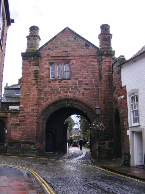
Abbey Gatehouse
- Overview Map Street View Abbey Gatehouse is located at the corner of Abbey Street and Paternoster Row in Carlisle. The Gatehouse is dated 1528, built as the gate tower to St …
Co-Curate Page
Eden Bridge
- Overview Map Street View Eden Bridge in Carlisle is a road bridge over the River Eden connecting the city centre to Stanwix to the north. The bridge, with 5 segmental …
Co-Curate Page
Market Cross
- Overview Map Street View The Market Cross in Carlisle was built in 1682 on the site of a previous medieval cross. It is inscribed "JOSEPH REED MAYOR 1682" and features …
Co-Curate Page
Guildhall Museum
- Overview Map Street View The former Guildhall (nos. 5 & 6 Greenmarket) is one of the oldest buildings in Carlisle. The timber-framed building was constructed between 1396 and 1407 for …
Co-Curate Page
Rickerby Park
- Overview About Rickerby Park Map Street View Rickerby Park is a public open space in Carlisle, Cumbria on the banks of the River Eden. The parkland is dotted with …
Co-Curate Page
Cumberland and Westmorland Joint Counties’ War Memorial
- Overview Map Street View
Co-Curate Page
Church of St Cuthbert
- Overview Map Street View "The Church stands not east-west but square to the Roman Road north through Carlisle (the A6, in town Blackfriars St). It is therefore of early foundation, …
Co-Curate Page
Tithe Barn, Carlisle
- Overview Map Street View The former Tithe barn for the Augustinian Priory of St Mary is located on West Walls by Heads Lane in Carlisle. It was built in the …
Co-Curate Page
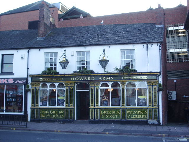
Howard Arms, Carlisle
- Overview Map Street View The Howard Arms is a public house on the west side of Lowther Street in Carlisle. Originally, it was one of 2 adjoining houses built in …
Co-Curate Page
The Redfern, Etterby
- Overview Map Street View The Redfern is a public house located on Kingmoor Road, in the Etterby area of Carlisle. It was opened on the 1st of October 1940 and …
Co-Curate Page
Cumberland Inn, Carlisle
- Overview Map Street View The Cumberland Inn, no. 22 Botchergate in Carlsile is public house built under the Carlisle and District State Management Scheme. Designed by Harry Redfern in a 'Tudor …
Co-Curate Page
Carlisle Railway Station
- Overview About Carlisle Station Map Street View Carlisle Citadel Station was built by the Lancaster and Carlisle Railway and Caledonian Railway in 1847; the crests of both companies can be …
Co-Curate Page
Old Town Hall
- Overview About the Old Town Hall Map Street View The Old Town Hall is located at the north end of the Market Place in Carlisle. It was built in 1669, …
Co-Curate Page
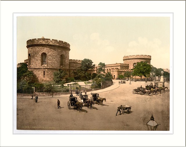
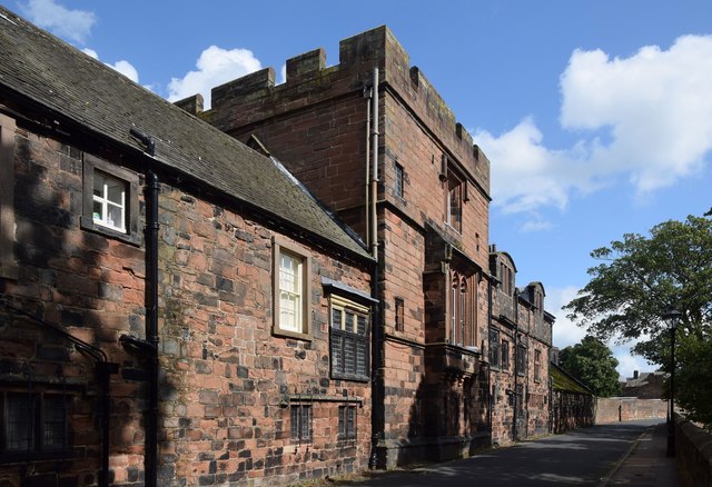
Carlisle Citadel
- Overview About Carlisle Citadel Map Street View Carlisle Citadel or The Citadel is a former medieval fortress on English Street in Carlisle, Cumbria. It comprises two towers, both of which …
Co-Curate Page
Old Cumberland Infirmary
- Overview Map Street View The original Cumberland Infirmary on Newtown Road in Carlisle was built 1830-1832 by Richard Tattersall, funded by wealthy benefactors, and made available for charity patients. The …
Co-Curate Page
De Irebys Tower, Carlisle Castle
- De Irebys Tower and the adjoining outer bailey wall of Carlisle Castle is Grade I listed on the National Heritage List for England. "Gate tower and curtain walls, with interval towers. C12 …
Co-Curate Page
Congregational Church, Carlisle
- Overview Map Street View Lowther Street Congregational Church (aka Carlisle City Church) in Carlisle, was built 1842-1843, designed by John Nichol of Edinburgh. It replaced an earlier place of worship …
Co-Curate Page
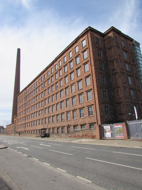
Shaddon Mill
- Overview Map Street View Shaddon Mill is located on Junction Street, off Shaddongate in Carlisle. It was built as a cotton mill 1835-1836 by Richard Tattersall for Peter Dixon. At …
Co-Curate Page
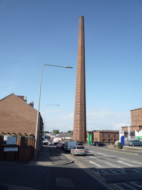
Dixons Chimney, Shaddon Mill, Carlisle
- Overview Map Street View Dixons Chimney is a prominent landmark in Carlisle, located on the corner of Shaddongate and Junction Street. The chimney was built in 1836 to serve Shaddon …
Co-Curate Page
Church of St Andrew, Botcherby, Carlisle
- Overview Map Street View St Andrew's Church is located on Wood Street in Botcherby, Carlisle. It was built as a Mission Church in 1890, to the designs of Henry Higginson …
Co-Curate Page
Church of St Aidan, Carlisle
- Overview Map Street View St Aidan's Church is located on Warwick Road, Carlisle. This Church of England church was designed by C.J. Ferguson. The foundation stone was laid on the …
Co-Curate Page
Coledale Hall, Carlisle
- Overview Map Street View Coledale Hall is located on Newtown Road in Carlisle. It was originally built in 1810 as a house and stable range for Henry Fawcett, MP for …
Co-Curate Page
Church of St Michael, Stanwix
- Overview Map Street View St Michael's Church is located on Church Street in Stanwix, Carlisle. The current building stands on a medieval site, which was previously the location of a …
Co-Curate Page
Monument to Dean Tait's Children, Stanwix
- In the churchyard of St Michael's Church in Stanwix, is a monument to the 5 children of Dean Tait, who died within weeks of each other of smallpox in 1856. …

Co-Curate Page
Church of St James, Longsowerby
- Overview Map Street View St James' Church is located on St James' Road in the Longsowerby area of Carlisle. The church was built 1865-1867 by Anderson & Pepper of Bradford. …
Co-Curate Page
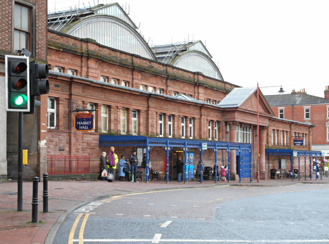
Market Hall, Carlisle
- Overview Map Street View The Market Hall in Carlisle is an extensive indoor market which has entrances on Fisher Steet, Scotch Street, Market Street and West Tower Street. The Market …
Co-Curate Page
Methodist Central Hall, Carlisle
- Overview Map Street View Central Hall on Fisher Street in Carlise was built in 1922 on the site of previous Wesleyan chapels of 1786 and 1834. The present building was …
Co-Curate Page
Our Lady & Saint Joseph's Church, Carlisle
- Overview Map Street View Our Lady & Saint Joseph's Catholic Church is located on Warwick Road in Carlisle. The foundation stone was laid on the 18th of May 1891, on …
Co-Curate Page
Bishop's Registry, Carlisle
- Overview Map Street View Adjacent to the Abbey Gatehouse in Carlisle is the small "Bishop's Registry" building of 1699. This is the former Cathedral library, at one time used as …
Co-Curate Page
Elim Community Church (St Paul's), Carlisle
- Overview Map Street View Elim Community Church stands on the corner of Lonsdale Street and Spencer Street, and around St Paul's Square, in Carlisle. The building was originally St Paul's …
Co-Curate Page
The Horse and Farrier, Wigton Road, Carlisle
- Overview Map Street View The Horse and Farrier is a public house at the junction of Wigton Road and Orton Road in Carlisle. The pub is dated 1928, built for …
Co-Curate Page
Old Milestone, Wigton Road, Carlisle
- Overview Map Street View There is an old milestone beside Wigton Road (A595) at the junction with Suttle Lane in the Morton area of Carlisle. The milestone was erected by …
Co-Curate Page
Old Church of St George, Carlisle
- Overview Map Street View The former Church of St. George, United Reformed Church, is located at 35 Warwick Road, Carlisle. Originally a English Presbyterian Church, the foundation stone was laid …
Co-Curate Page
Old Milestone, Kingstown Road, Carlisle
- Overview Map Street View This old milestone is at the side of A7, Kingstown Road, in the Kingstown area of Carlisle. It is situated outside Subway, which was the site …
Co-Curate Page
Gallaghers Bar (former Golden Lion), Carlisle
- Overview Map Street View Gallaghers Bar is located at the junction of St Nicholas Street and Botchergate in Carlisle. It is thought to have originally been 3 houses, built in …
Co-Curate Page
Old Milestone, London Road
- Overview Map Street View There is an old milestone by London Road (A6) in Harraby, Carlisle. The milestone was erected in the early 19th century for the Carlisle and Eamont …
Co-Curate Page
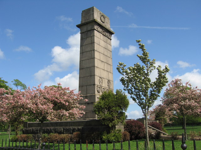
Creighton Memorial, Carlisle
- Overview Map Street View The Creighton Memorial is located in Hardwicke Circus in Carlisle. This memorial was erected in 1898 in honour of J.R. Creighton, Alderman and twice Mayor of …
Co-Curate Page
The Boardroom, Carlisle
- Overview Map Street View The Boardroom is a public house, located on the corner of Castle Street and Paternoster Row in Carlisle. The building dates from at least the late …
Co-Curate Page
Magpie Inn, Carlisle
- Overview Map Street View The Magpie Inn is located by the junction of Victoria Road and Banks Lane in Botcherby, Carlisle. The public house was built in 1933 to designs …
Co-Curate Page
St George’s URC Church (former Grammar School), Carlisle
- Overview Map Street View St George’s United Reform Church (URC) is located on West Walls in Carlisle. The building was originally the Grammar School, built in 1832 for the Dean …
Co-Curate Page
Fratry, Carlisle Cathedral
- Overview Map Street View The Fratry at Carlisle Cathedral is the former dining hall for the Priory of St Mary, which dates from the 15th century. It was built between …

Co-Curate Page
32 Abbey Street (former Police Station), Carlisle
- Overview Map Street View No. 32 Abbey Street in Carlisle was built in c.1817 as a home for Christopher William Hutchinson of Temple Sowerby. The property was purchased in 1905 …
Co-Curate Page
Nos. 1 & 3 Abbey Street, Carlisle
- Overview Map Street View Nos. 1 & 3 Abbey Street, Carlisle, was originally a house and shop extension dating from the late 18th or early 19th century. It was later …
Co-Curate Page
Tullie House, Carlisle
- Overview Map Street View Tullie House and gardens are located on Abbey Street in Carlisle and form part of The Tullie museum and gallery complex. There has been a substantial …
Co-Curate Page
Tile Tower and section of West City Walls
- Overview Map Street View A section of the West City Walls in Carlisle, including Tile Tower, runs from Carlisle Castle to todays Castle Way road. The walls date from the …
Co-Curate Page
Nos. 10-22, West Walls, Carlisle
- Overview Map Street View Nos. 10-22, West Walls (road) in Carlisle are 19th century buildings, notable for including a section of the 12th century West City Walls. The buildings are …
Co-Curate Page
No. 21, Castle Street
- Overview Map Street View No. 21, Castle Street, Carlisle, was built in the late 18th century. Originally a house, it was later converted for commercial use. It is currently occuplied …
Co-Curate Page
No 3, Castle Street, Carlisle
- Overview Map Street View No 3, Castle Street, Carlisle, was built in the 1840s as a house for George Gill Mounsey. It is now used as offices. The building is …
Co-Curate Page
The Deanery and Prior's Tower, The Abbey, Carlisle
- Overview Map Street View The Deanery and Prior's Tower (Nos. 5, 5a & 5b, The Abbey) faces Carlisle Cathedral. Prior's tower and adjoining hall range was originally built in the …
Co-Curate Page
Dormitory of former Priory of St Mary (ruins), Carlisle
- Overview Map Street View The ruins of the Dormitory (or 'dorter') stand beside Carlisle Cathedral. The dormitory, built for the Priory of St Mary, dates from the 13th century. This …
Co-Curate Page
Nos. 30-40 Lowther Street & No. 1 Lonsdale Street, Carlisle
- Overview Map Street View Nos. 30-40 Lowther Street and No. 1 Lonsdale Street in Carlisle are a terrace of 7 Georgian houses and Alliance Chambers, which is located on the …
Co-Curate Page
Section of West City Walls at site of former Central Plaza Hotel, Carlisle
- Overview Map Street View There is a section of the 12th century City Walls by West Walls (street) in Carlisle, located between 22 Backhouse Walk and Victoria Viaduct. Previously, this …
Co-Curate Page
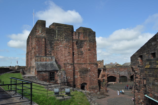
Captain's Tower and Inner Bailey, Carlisle Castle
- Overview Map Street View The Captain's Tower is the main gateway into the inner bailey of Carlisle Castle. The inner bailey is roughly triangular in shape, comprising north, south and …

Co-Curate Page
Section of North City Walls adjoining Carlisle Castle
- Overview Map Street View A short section of the North City Walls survives in Carlisle. The section of Medieval wall is about 75 metres long, connecting with Carlisle Castle. Where …
Co-Curate Page
The Militia Store, Inner Bailey
- Overview Map Street View The Militia Store, located within the Inner Bailey of Carlisle Castle, was built in 1881. the building is Grade II listed on the National Heritage List …
Co-Curate Page
Bridge over outer moat, Carlisle Castle
- Overview Map Street View There is a stone bridge over the outer moat at Carlisle Castle, leading to the main gateway ino the castle through De Irebys Tower. This was …
Co-Curate Page
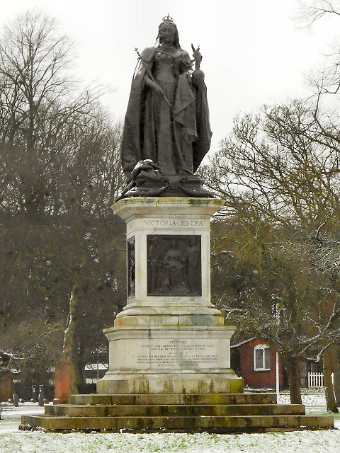
Statue of Queen Victoria, Bitts Park
- Overview Map Street View This Statue of Queen Victoria is located in the Victoria Park section of Bitts Park in Carlisle. The monument was erected in 1902 and was designed …

Co-Curate Page
City boundary stone, Weavers Bank, Carlisle
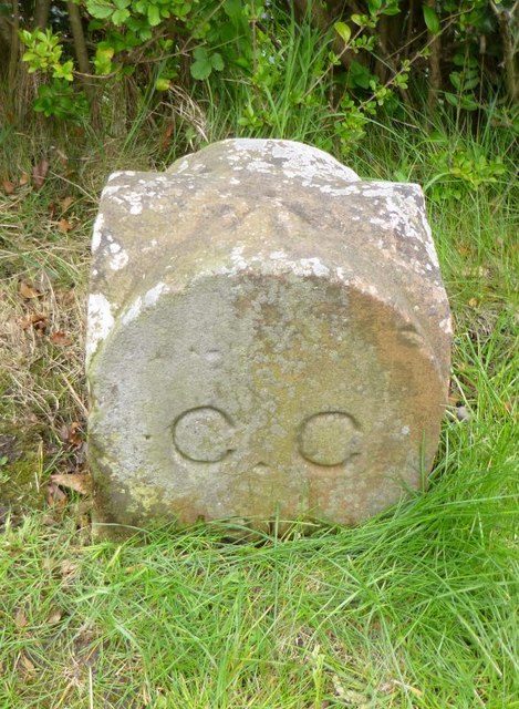
- Overview Map This old city boundary stone is located by Weavers Bank in Bitts Park, Carlisle. It dates from the 1830s or 1840s and is inscribed on 2 faces "C.C." …
Co-Curate Page
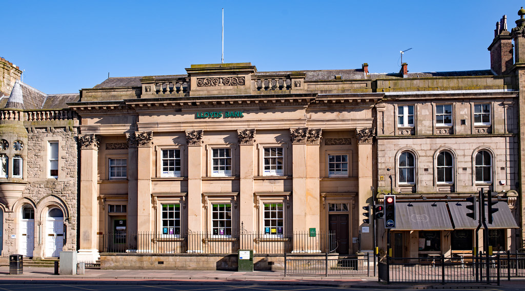
Lloyds Bank, Lowther Street
- Overview Map Street View Lloyds Bank is located at No. 6, Lowther Street, Carlisle. The building dates from 1840. It was originally an Athenaeum with a lecture theatre, museum, library, …
Co-Curate Page
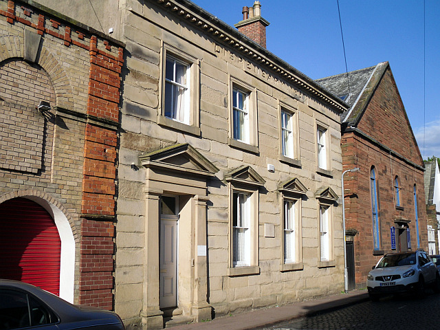
Old Dispensary, Carlisle
- Overview Map Street View The Dispensary is located at No. 6, Chapel Street, Carlisle. It was built in 1857, deigned by John Hodgson of Carlisle, to rehouse the Dispensary (a …

Co-Curate Page
Nos, 2-9 Chapel Street, Carlisle
- Overview Map Street View Nos, 2-9 Chapel Street, Carlisle, are a terrace of houses built in the 19th century. The houses have Flemish bond brickwork with light headers, which was …
Co-Curate Page
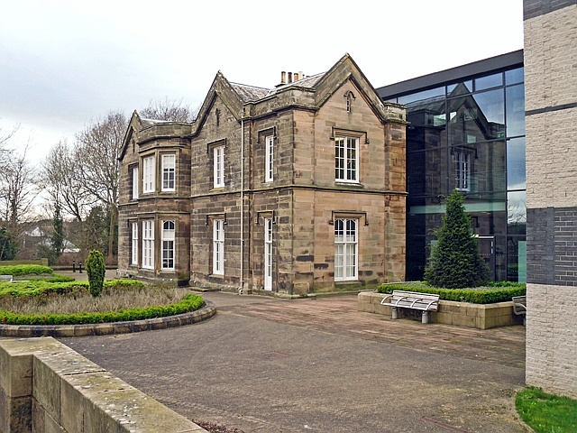
Lady Gillford's House, Carlisle
- Overview Map Street View Lady Gillford's House is located on Petreli Bank Road in Carlisle. It was built in c.1829, for John Fawcett, attorney. The building, originally known as Petreli …
Co-Curate Page
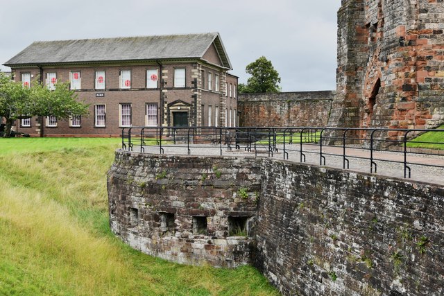
Alma Block, Outer Bailey, Carlisle Castle
- Overview Map Street View The Alma Block is located in the Outer Bailey of Carlisle Castle. The building now hosts Cumbria's Museum of Military Life. The Alma Block was originally …
Co-Curate Page
Former Railway Goods Station, London Road, Harraby
- This former railway goods station is located on London Road in Harraby, Carlisle. The railway goods sheds and office building were built in 1881, designed by William Bell, architect for …
Co-Curate Page
Currock House Community Centre
- Overview Map Street View Currock House Community Centre is located on Lediard Avenue in Currock, Carlisle. Currock House was originally, built as a house in the 19th century. A house …
Co-Curate Page
Railway Inn, London Road, Carlisle
- Overview Map Street View The former Railway Inn is located at No. 104, London Road in Carlisle. It was originally built in 1837 as the Station Hotel to serve passengers …
Co-Curate Page
Harraby Toll Cottage
- Overview Map Street View No.258, London Road in Carlisle is the former cottage for the Harraby Toll Gate of the Carlisle to Eamont Bridge Turnpike (established 1752). The cottage was …
Co-Curate Page
The Turf Inn, Newark Road, Carlisle
- Overview Map Street View The Turf is a public house and restaurant located on Newark Road in Carlisle. It was originally built 1839-1840 as the Grandstand hotel for Carlisle Racecourse …
Co-Curate Page
The Sportsman Inn, Carlisle
- Overview Map Street View The Sportsman is a public house located on Heads Lane, by the junction with Blackfriars Street in Carlise. The inn originates from the early 18th century. …
Co-Curate Page
Crown and Mitre Hotel, Carlisle
- Overview Map Street View The Crown and Mitre Hotel is located in Carlisle at Nos. 4-10, English Street and includes No.54 Castle Street. The hotel, with shops beneath, was built …
Co-Curate Page
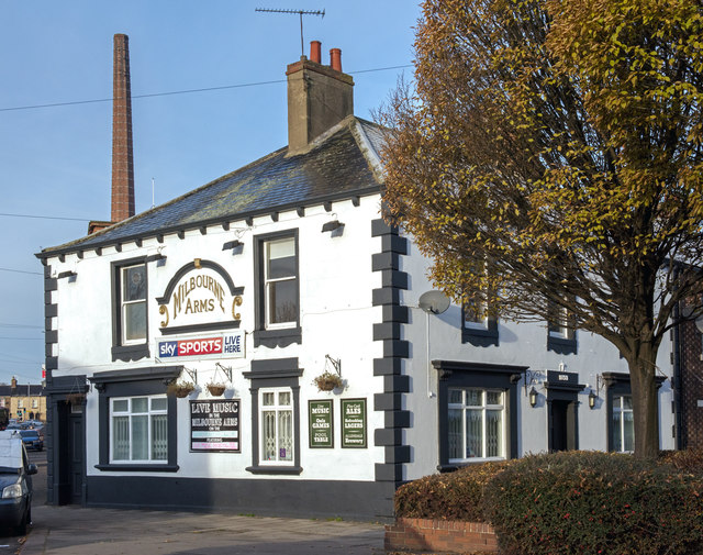
Milbourne Arms, Denton Holme
- Overview Map Street View The Milbourne Arms is a public house located at the south end of Milbourne Street by Junction Street, in Denton Holme, Carlisle. It was built 1852-1853.[1] …
Co-Curate Page
Former Pheasant Inn, Church Street, Carlisle
- Overview Map Street View The former Pheasant Inn is located on Church Street, Carlisle. Originally it was a row of 3 houses built in the late 18th century. It appears …
Co-Curate Page
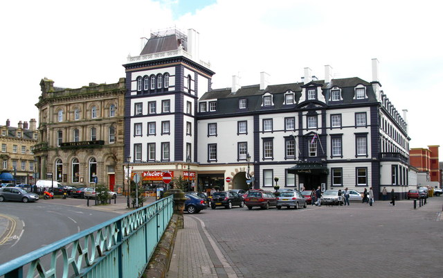
Carlisle Station Hotel
- Overview Map Street View Carlisle Station Hotel is located on Court Square, Carlisle, a short distance from Carlisle Railway Station. The hotel was built in 1852 for George Head Head …
Co-Curate Page
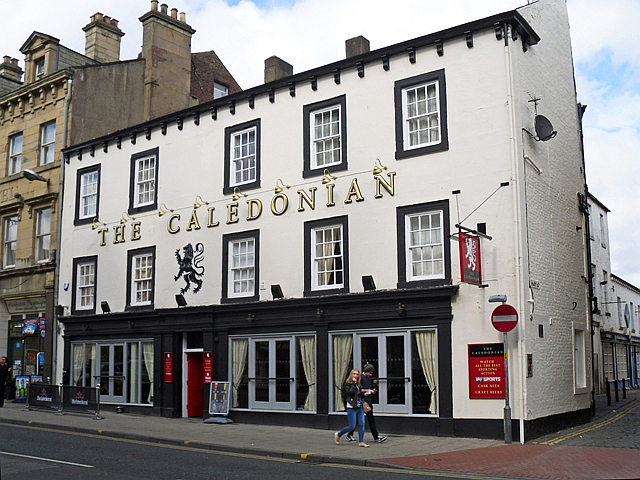
The Caledonian, Botchergate, Carlisle
- Overview Map Street View The Caledonian is a public house on Botchergate, at the junction with Mary Street, in Carlisle. The first reference to this pub is found in 1852 …
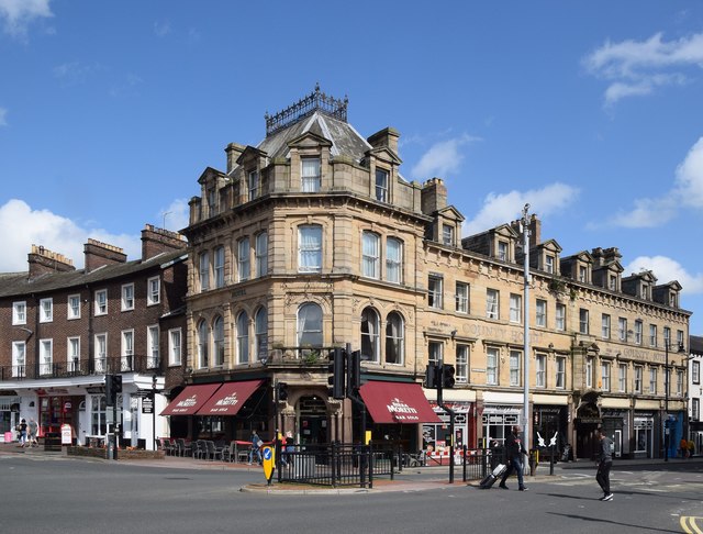
Co-Curate Page
County Hotel, Botchergate
- Overview Map Street View The County Hotel is located on the corner of Botchergate and The Crescent in Carlisle. It was originally built 1894-1896 and named The Red Lion Hotel. The …
Co-Curate Page
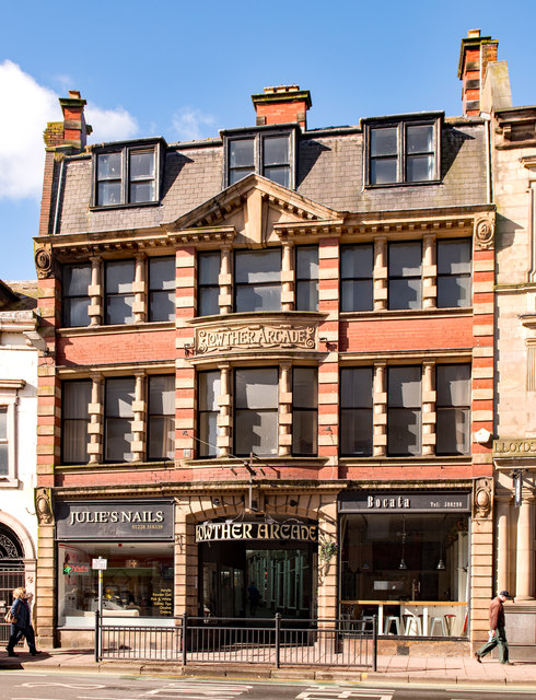
Nos. 15 & 17 Lowther Street, Carlisle
- Overview Map Street View Nos. 15 & 17 Lowther Street in Carlisle includes the East entrance to Lowther Arcade. The building has 2 shops with offices above. Dated 1904, this …
Co-Curate Page
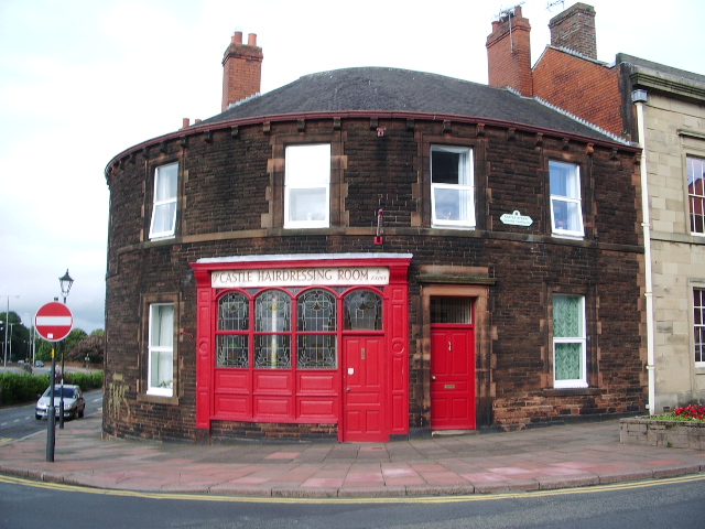
No. 1, Castle Street, Carlisle
- Overview Map Street View No.1, Castle Street, on the corner with Finkle Street, in Carlisle hosts the Castle Hairdressing Room. The building dates from the mid-1890's, after an earlier house …
Co-Curate Page
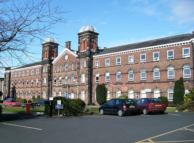
Skiddaw Building, Carlisle
- Overview Map Street View The Skiddaw Building in Carlisle is one of the principle buildings of the Fusehill Street Campus of the University of Cumbria. The building was originally the …

Co-Curate Page
Blencathra Building, Carlisle
- Overview Map Street View The Blencathra Building in Carlisle is on the Fusehill Street Campus of the University of Cumbria. The building was originally the hospital wing of the Union …
Co-Curate Page
Crozier Lodge, Cumberland Infirmary
- Overview Map Street View Crozier Lodge at Cumberland Infirmary, in Carlisle, was originally a house built in the 1820s. Thomas McAdam was recorded as living here in 1828.[1] A House …

Co-Curate Page
Hyssop Holme Well
- Overview Map Hyssop Holme Well in Stanwix, Carlisle, is located just off the footpath which runs south parallel to Cavendish Terrace and a short distance to the north-west of Carlisle …
Co-Curate Page
Old Carlisle City Boundary Stone, Whiteclosegate
- Overview Map Street View There is an old Carlisle City boundary stone by the B6264, outside No. 2 Whiteclosegate, just north of the B6264 junction with Longlands Road. The boundary …
Co-Curate Page
Old Carlisle City Boundary Stone, Harraby
- There is an old Carlisle City boundary stone is located between Nos. 417 and 419, London Road (A6), in Harraby. The boundary stone is marked "CC 1912". The stone was …
Co-Curate Page
No 18, Fisher Street
- Overview Map Street View No 18, Fisher Street in Carlisle dates from the late 18th century. The building, with Flemish bond brickwork, was originally 2 houses, later divided into shop units. …
Co-Curate Page
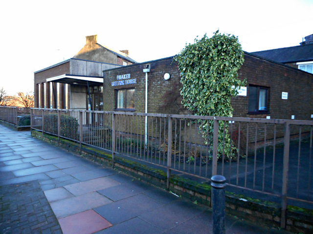
Ouaker Meeting House, Carlisle
- Overview Map Street View This Quaker Meeting House is located on Fisher Street in Carlisle. It is a relatively modern building of 1963. However, the site was originally a Quaker …
Co-Curate Page
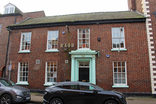
No. 20, Fisher Street
- Overview Map Street View No. 20, Fisher Street, Carlisle was built in the early 19th century. Built as a house, the building with Flemish bond brickwork, is now the RAOB members …
Co-Curate Page
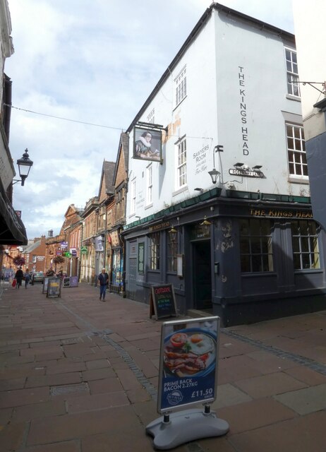
The Kings Head, Carlisle
- Overview Map Street View The Kings Head on Fisher Street is reputed to be the oldest public house in Carlisle. The present building dates from the 17th Century (with later …
Co-Curate Page
No. 15, Fisher Street
- Overview Map Street View No. 15, Fisher Street in Carlisle is the former Town Clerk's Office, dated 1879. The building is at the corner of Fisher Street and Market Street. …
Co-Curate Page
No. 11, Fisher Street, Carlisle
- Overview Map Street View No. 11, Fisher Street, Carlisle, was built in c.1800. It was originally built as a house for Robert Ferguson, son of a prosperous textile manufacturer. It …
Co-Curate Page
The Andalusian, Carlisle
- Overview Map Street View The Andalusian is a bar and resurant on Warwick Road, by the junction with The Cresent, in Carlisle. Originally it was "The Crescent Inn", built in …
Co-Curate Page
The Cranemakers, Carlisle
- Overview Map Street View The Cranemakers is a public house on London Road, by the junction of Grey Street, in Carlisle. The building was originally constructed as a house in …

Co-Curate Page
St Nicholas Arms, London Road, Carlisle
- Overview Map Street View St Nicholas Arms is a public house located on London Road, by the junction with Grey Street, in Carlisle. Originally a large house, (shown on the …
Co-Curate Page
Former White Ox, St Nicholas Street, Carlisle
- Overview Map Street View The former White Ox public hose is located on St Nicholas Street, at the junction with Woodroufe Terrace, in Carlisle. It was built in c.1852, and …

Co-Curate Page
Nos. 5-61, St Nicholas Street, Carlisle
- Overview Map Street View Nos. 5-61, St Nicholas Street in Carlisle are a terrace of 28 houses, built in the 1840s and early 1850s. The terrace features Flemish bond brickwork. Houses …

Co-Curate Page
No. 2, The Abbey, Carlisle
- Overview Map Street View No. 2, The Abbey is a 17th century house located between Abbey Gateway and the Cathedral in Carlisle. It was built in the late 17th century …
Co-Curate Page
Woodroufe Terrace
- Overview Map Street View Woodroufe Terrace is a road in Carlisle, that runs between St Nicholas Street and London Road (A6). Nos.1-11, are a terrace of houses on the north …

Co-Curate Page
Church of St John the Evangelist, Carlisle
- Overview Map Street View St John the Evangelist Church is located on London Road, by the junction with Close Street, in Carlise. The church was officially opened by Dean Close …
Co-Curate Page
Carlisle Cemetery entrance lodge, Richardson Street
- Overview Map Street View Carlisle Cemetery entrance lodge is located on Richardson Street, Carlisle. The curator's house (No. 153 Richardson Street) and cemetery offices, Flemish bond brickwork, were built by …
Co-Curate Page
Abbey Court, Nos. 1 & 2, Paternoster Row
- Overview Map Street View Abbey Court is Nos. 1 & 2, Paternoster Row in Carlisle. Originally it was built as 2 houses in the early 19th century, with later alterations. …
Co-Curate Page
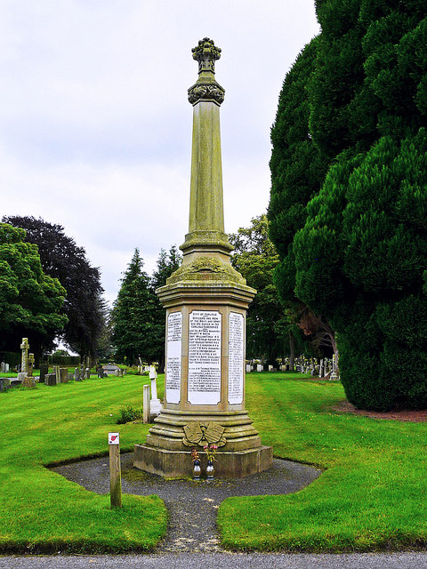
First World War Memorial, Carlisle Cemetery
- There is a war memorial in Carlisle Cemetery, consisting of a six sided sandstone column with white marble panels, insribed with the names of 145 local servicemen who lost their …
Co-Curate Page
Cross of Sacrifice, Carlisle Cemetery
- The Cross of Sacrifice at Carlisle Cemetery is situated by war graves, commemorating the sacrifice and bravery of Commonwealth soldiers during the First and Second World War. The cross is …
Co-Curate Page
Peter Nicholson Monument, Carlisle Cemetery
- There is a monument to the eminent achrchitect Perter Nicholson (1765-1844) in Carlisle Cemetery. It was designed by Robert William Billings, illustrator and architect (1813-1874). Billings published the design of …
Co-Curate Page
Carlisle Cemetery Chapel
- Mortuary chapel (formerly the Anglican chapel) for Carlisle Cemetery. 1855-1856 by Messrs JM & J Hay of Liverpool. Flemish bond red brick. Grade II listed on the National Heritage List …

Co-Curate Page
Nonconformist Chapel for Carlisle cemetery
- Former nonconformist chapel for Carlisle Cemetery
Co-Curate Page
Carlisle Cemetery
- Overview Map Street View Carlisle Cemetry is located on Dalston Road, with an entrance on Richardson Street in Carlisle. The cemetery was originally laid out in 1855 with offices, chapels, …
Co-Curate Page
West Lodge, Carlisle Cemetery
- Overview Map Street View The West Lodge is located by the Dalston Road entrance of Carlisle Cemetery. It was built 1855-1856, by Messers JM & J Hay of Liverpool, when …

Co-Curate Page
Gateway to Carlisle Cemetery, Dalston Road
- Overview Map Street View The gates and gate piers for Carlisle Cemetery, on Dalston Road, Carlisle, were built 1855-1856 by Messrs JM & J Hay of Liverpool. The gates and …
Co-Curate Page
Statue of James Steel, Carlisle
- Overview Map Street View A statue of James Steel stands on the west side of English Street in Carlisle. James Steet (1797 - 1851) was an editor of the Carlisle …
Co-Curate Page
Statue of Francis Aglionby
- Overview Map Street View The statue of Francis Aglionby is located on Earl Street in Carlisle. The statue was designed by the renound sculptor, Musgrave Lewthwaite Watson, and erected in …

Co-Curate Page
Wall Mile 65
- <Mile 64 | Mile 65 | Mile 66> Hadrian's Wall - Wall Mile 65 Hadrian's Wall stretches from the east to west coast of England and was an important frontier …
Co-Curate Page
Wall Mile 66
- <Mile 65 | Mile 66 | Mile 67> Hadrian's Wall - Wall Mile 66 Hadrian's Wall stretches from the east to west coast of England and was an important frontier …

Co-Curate Page
Waverley Viaduct, Carlisle
- Overview Map Street View Waverley Viaduct (aka Engine Lonning Bridge) is a disused railway bridge over the River Eden in Carlisle. The viaduct was built in 1861 for the North …

Co-Curate Page
Carlisle Castle
- Overview About Carlisle Castle Map Street View Carlisle Castle is built on the site of a Roman fort (known as Luguvalium). Construction of a motte and bailey castle began in …
Co-Curate Page
City Walls
- The city walls in Carlisle were built in the 12th century. The walls enclosed the city south of the castle, which was built in 1112 AD. The city walls included …
Co-Curate Page
Carlisle Cathedral
- Overview About Carlisle Cathedral Map Street View (Inside) The distinctive red sandstone cathedral is located in the centre of Carlisle. It was founded as a Norman Priory Church by King …
Co-Curate Page
Abbey Gatehouse
- Overview Map Street View Abbey Gatehouse is located at the corner of Abbey Street and Paternoster Row in Carlisle. The Gatehouse is dated 1528, built as the gate tower to St …
Co-Curate Page
Eden Bridge
- Overview Map Street View Eden Bridge in Carlisle is a road bridge over the River Eden connecting the city centre to Stanwix to the north. The bridge, with 5 segmental …
Co-Curate Page
Market Cross
- Overview Map Street View The Market Cross in Carlisle was built in 1682 on the site of a previous medieval cross. It is inscribed "JOSEPH REED MAYOR 1682" and features …
Co-Curate Page
Guildhall Museum
- Overview Map Street View The former Guildhall (nos. 5 & 6 Greenmarket) is one of the oldest buildings in Carlisle. The timber-framed building was constructed between 1396 and 1407 for …
Co-Curate Page
Rickerby Park
- Overview About Rickerby Park Map Street View Rickerby Park is a public open space in Carlisle, Cumbria on the banks of the River Eden. The parkland is dotted with …
Co-Curate Page
Cumberland and Westmorland Joint Counties’ War Memorial
- Overview Map Street View
Co-Curate Page
Church of St Cuthbert
- Overview Map Street View "The Church stands not east-west but square to the Roman Road north through Carlisle (the A6, in town Blackfriars St). It is therefore of early foundation, …
Co-Curate Page
Tithe Barn, Carlisle
- Overview Map Street View The former Tithe barn for the Augustinian Priory of St Mary is located on West Walls by Heads Lane in Carlisle. It was built in the …
Co-Curate Page
Howard Arms, Carlisle
- Overview Map Street View The Howard Arms is a public house on the west side of Lowther Street in Carlisle. Originally, it was one of 2 adjoining houses built in …
Co-Curate Page
The Redfern, Etterby
- Overview Map Street View The Redfern is a public house located on Kingmoor Road, in the Etterby area of Carlisle. It was opened on the 1st of October 1940 and …
Co-Curate Page
Cumberland Inn, Carlisle
- Overview Map Street View The Cumberland Inn, no. 22 Botchergate in Carlsile is public house built under the Carlisle and District State Management Scheme. Designed by Harry Redfern in a 'Tudor …
Co-Curate Page
Carlisle Railway Station
- Overview About Carlisle Station Map Street View Carlisle Citadel Station was built by the Lancaster and Carlisle Railway and Caledonian Railway in 1847; the crests of both companies can be …
Co-Curate Page
Old Town Hall
- Overview About the Old Town Hall Map Street View The Old Town Hall is located at the north end of the Market Place in Carlisle. It was built in 1669, …
Co-Curate Page
Carlisle Citadel
- Overview About Carlisle Citadel Map Street View Carlisle Citadel or The Citadel is a former medieval fortress on English Street in Carlisle, Cumbria. It comprises two towers, both of which …
Co-Curate Page
Old Cumberland Infirmary
- Overview Map Street View The original Cumberland Infirmary on Newtown Road in Carlisle was built 1830-1832 by Richard Tattersall, funded by wealthy benefactors, and made available for charity patients. The …
Co-Curate Page
De Irebys Tower, Carlisle Castle
- De Irebys Tower and the adjoining outer bailey wall of Carlisle Castle is Grade I listed on the National Heritage List for England. "Gate tower and curtain walls, with interval towers. C12 …
Co-Curate Page
Congregational Church, Carlisle
- Overview Map Street View Lowther Street Congregational Church (aka Carlisle City Church) in Carlisle, was built 1842-1843, designed by John Nichol of Edinburgh. It replaced an earlier place of worship …
Co-Curate Page
Shaddon Mill
- Overview Map Street View Shaddon Mill is located on Junction Street, off Shaddongate in Carlisle. It was built as a cotton mill 1835-1836 by Richard Tattersall for Peter Dixon. At …
Co-Curate Page
Dixons Chimney, Shaddon Mill, Carlisle
- Overview Map Street View Dixons Chimney is a prominent landmark in Carlisle, located on the corner of Shaddongate and Junction Street. The chimney was built in 1836 to serve Shaddon …
Co-Curate Page
Church of St Andrew, Botcherby, Carlisle
- Overview Map Street View St Andrew's Church is located on Wood Street in Botcherby, Carlisle. It was built as a Mission Church in 1890, to the designs of Henry Higginson …
Co-Curate Page
Church of St Aidan, Carlisle
- Overview Map Street View St Aidan's Church is located on Warwick Road, Carlisle. This Church of England church was designed by C.J. Ferguson. The foundation stone was laid on the …
Co-Curate Page
Coledale Hall, Carlisle
- Overview Map Street View Coledale Hall is located on Newtown Road in Carlisle. It was originally built in 1810 as a house and stable range for Henry Fawcett, MP for …
Co-Curate Page
Church of St Michael, Stanwix
- Overview Map Street View St Michael's Church is located on Church Street in Stanwix, Carlisle. The current building stands on a medieval site, which was previously the location of a …
Co-Curate Page
Monument to Dean Tait's Children, Stanwix
- In the churchyard of St Michael's Church in Stanwix, is a monument to the 5 children of Dean Tait, who died within weeks of each other of smallpox in 1856. …
Co-Curate Page
Church of St James, Longsowerby
- Overview Map Street View St James' Church is located on St James' Road in the Longsowerby area of Carlisle. The church was built 1865-1867 by Anderson & Pepper of Bradford. …
Co-Curate Page
Market Hall, Carlisle
- Overview Map Street View The Market Hall in Carlisle is an extensive indoor market which has entrances on Fisher Steet, Scotch Street, Market Street and West Tower Street. The Market …
Co-Curate Page
Methodist Central Hall, Carlisle
- Overview Map Street View Central Hall on Fisher Street in Carlise was built in 1922 on the site of previous Wesleyan chapels of 1786 and 1834. The present building was …
Co-Curate Page
Our Lady & Saint Joseph's Church, Carlisle
- Overview Map Street View Our Lady & Saint Joseph's Catholic Church is located on Warwick Road in Carlisle. The foundation stone was laid on the 18th of May 1891, on …
Co-Curate Page
Bishop's Registry, Carlisle
- Overview Map Street View Adjacent to the Abbey Gatehouse in Carlisle is the small "Bishop's Registry" building of 1699. This is the former Cathedral library, at one time used as …
Co-Curate Page
Elim Community Church (St Paul's), Carlisle
- Overview Map Street View Elim Community Church stands on the corner of Lonsdale Street and Spencer Street, and around St Paul's Square, in Carlisle. The building was originally St Paul's …
Co-Curate Page
The Horse and Farrier, Wigton Road, Carlisle
- Overview Map Street View The Horse and Farrier is a public house at the junction of Wigton Road and Orton Road in Carlisle. The pub is dated 1928, built for …
Co-Curate Page
Old Milestone, Wigton Road, Carlisle
- Overview Map Street View There is an old milestone beside Wigton Road (A595) at the junction with Suttle Lane in the Morton area of Carlisle. The milestone was erected by …
Co-Curate Page
Old Church of St George, Carlisle
- Overview Map Street View The former Church of St. George, United Reformed Church, is located at 35 Warwick Road, Carlisle. Originally a English Presbyterian Church, the foundation stone was laid …
Co-Curate Page
Old Milestone, Kingstown Road, Carlisle
- Overview Map Street View This old milestone is at the side of A7, Kingstown Road, in the Kingstown area of Carlisle. It is situated outside Subway, which was the site …
Co-Curate Page
Gallaghers Bar (former Golden Lion), Carlisle
- Overview Map Street View Gallaghers Bar is located at the junction of St Nicholas Street and Botchergate in Carlisle. It is thought to have originally been 3 houses, built in …
Co-Curate Page
Old Milestone, London Road
- Overview Map Street View There is an old milestone by London Road (A6) in Harraby, Carlisle. The milestone was erected in the early 19th century for the Carlisle and Eamont …
Co-Curate Page
Creighton Memorial, Carlisle
- Overview Map Street View The Creighton Memorial is located in Hardwicke Circus in Carlisle. This memorial was erected in 1898 in honour of J.R. Creighton, Alderman and twice Mayor of …
Co-Curate Page
The Boardroom, Carlisle
- Overview Map Street View The Boardroom is a public house, located on the corner of Castle Street and Paternoster Row in Carlisle. The building dates from at least the late …
Co-Curate Page
Magpie Inn, Carlisle
- Overview Map Street View The Magpie Inn is located by the junction of Victoria Road and Banks Lane in Botcherby, Carlisle. The public house was built in 1933 to designs …
Co-Curate Page
St George’s URC Church (former Grammar School), Carlisle
- Overview Map Street View St George’s United Reform Church (URC) is located on West Walls in Carlisle. The building was originally the Grammar School, built in 1832 for the Dean …
Co-Curate Page
Fratry, Carlisle Cathedral
- Overview Map Street View The Fratry at Carlisle Cathedral is the former dining hall for the Priory of St Mary, which dates from the 15th century. It was built between …
Co-Curate Page
32 Abbey Street (former Police Station), Carlisle
- Overview Map Street View No. 32 Abbey Street in Carlisle was built in c.1817 as a home for Christopher William Hutchinson of Temple Sowerby. The property was purchased in 1905 …
Co-Curate Page
Nos. 1 & 3 Abbey Street, Carlisle
- Overview Map Street View Nos. 1 & 3 Abbey Street, Carlisle, was originally a house and shop extension dating from the late 18th or early 19th century. It was later …
Co-Curate Page
Tullie House, Carlisle
- Overview Map Street View Tullie House and gardens are located on Abbey Street in Carlisle and form part of The Tullie museum and gallery complex. There has been a substantial …
Co-Curate Page
Tile Tower and section of West City Walls
- Overview Map Street View A section of the West City Walls in Carlisle, including Tile Tower, runs from Carlisle Castle to todays Castle Way road. The walls date from the …
Co-Curate Page
Nos. 10-22, West Walls, Carlisle
- Overview Map Street View Nos. 10-22, West Walls (road) in Carlisle are 19th century buildings, notable for including a section of the 12th century West City Walls. The buildings are …
Co-Curate Page
No. 21, Castle Street
- Overview Map Street View No. 21, Castle Street, Carlisle, was built in the late 18th century. Originally a house, it was later converted for commercial use. It is currently occuplied …
Co-Curate Page
No 3, Castle Street, Carlisle
- Overview Map Street View No 3, Castle Street, Carlisle, was built in the 1840s as a house for George Gill Mounsey. It is now used as offices. The building is …
Co-Curate Page
The Deanery and Prior's Tower, The Abbey, Carlisle
- Overview Map Street View The Deanery and Prior's Tower (Nos. 5, 5a & 5b, The Abbey) faces Carlisle Cathedral. Prior's tower and adjoining hall range was originally built in the …
Co-Curate Page
Dormitory of former Priory of St Mary (ruins), Carlisle
- Overview Map Street View The ruins of the Dormitory (or 'dorter') stand beside Carlisle Cathedral. The dormitory, built for the Priory of St Mary, dates from the 13th century. This …
Co-Curate Page
Nos. 30-40 Lowther Street & No. 1 Lonsdale Street, Carlisle
- Overview Map Street View Nos. 30-40 Lowther Street and No. 1 Lonsdale Street in Carlisle are a terrace of 7 Georgian houses and Alliance Chambers, which is located on the …
Co-Curate Page
Section of West City Walls at site of former Central Plaza Hotel, Carlisle
- Overview Map Street View There is a section of the 12th century City Walls by West Walls (street) in Carlisle, located between 22 Backhouse Walk and Victoria Viaduct. Previously, this …
Co-Curate Page
Captain's Tower and Inner Bailey, Carlisle Castle
- Overview Map Street View The Captain's Tower is the main gateway into the inner bailey of Carlisle Castle. The inner bailey is roughly triangular in shape, comprising north, south and …
Co-Curate Page
Section of North City Walls adjoining Carlisle Castle
- Overview Map Street View A short section of the North City Walls survives in Carlisle. The section of Medieval wall is about 75 metres long, connecting with Carlisle Castle. Where …
Co-Curate Page
The Militia Store, Inner Bailey
- Overview Map Street View The Militia Store, located within the Inner Bailey of Carlisle Castle, was built in 1881. the building is Grade II listed on the National Heritage List …
Co-Curate Page
Bridge over outer moat, Carlisle Castle
- Overview Map Street View There is a stone bridge over the outer moat at Carlisle Castle, leading to the main gateway ino the castle through De Irebys Tower. This was …
Co-Curate Page
Statue of Queen Victoria, Bitts Park
- Overview Map Street View This Statue of Queen Victoria is located in the Victoria Park section of Bitts Park in Carlisle. The monument was erected in 1902 and was designed …
Co-Curate Page
City boundary stone, Weavers Bank, Carlisle
- Overview Map This old city boundary stone is located by Weavers Bank in Bitts Park, Carlisle. It dates from the 1830s or 1840s and is inscribed on 2 faces "C.C." …
Co-Curate Page
Lloyds Bank, Lowther Street
- Overview Map Street View Lloyds Bank is located at No. 6, Lowther Street, Carlisle. The building dates from 1840. It was originally an Athenaeum with a lecture theatre, museum, library, …
Co-Curate Page
Old Dispensary, Carlisle
- Overview Map Street View The Dispensary is located at No. 6, Chapel Street, Carlisle. It was built in 1857, deigned by John Hodgson of Carlisle, to rehouse the Dispensary (a …
Co-Curate Page
Nos, 2-9 Chapel Street, Carlisle
- Overview Map Street View Nos, 2-9 Chapel Street, Carlisle, are a terrace of houses built in the 19th century. The houses have Flemish bond brickwork with light headers, which was …
Co-Curate Page
Lady Gillford's House, Carlisle
- Overview Map Street View Lady Gillford's House is located on Petreli Bank Road in Carlisle. It was built in c.1829, for John Fawcett, attorney. The building, originally known as Petreli …
Co-Curate Page
Alma Block, Outer Bailey, Carlisle Castle
- Overview Map Street View The Alma Block is located in the Outer Bailey of Carlisle Castle. The building now hosts Cumbria's Museum of Military Life. The Alma Block was originally …
Co-Curate Page
Former Railway Goods Station, London Road, Harraby
- This former railway goods station is located on London Road in Harraby, Carlisle. The railway goods sheds and office building were built in 1881, designed by William Bell, architect for …
Co-Curate Page
Currock House Community Centre
- Overview Map Street View Currock House Community Centre is located on Lediard Avenue in Currock, Carlisle. Currock House was originally, built as a house in the 19th century. A house …
Co-Curate Page
Railway Inn, London Road, Carlisle
- Overview Map Street View The former Railway Inn is located at No. 104, London Road in Carlisle. It was originally built in 1837 as the Station Hotel to serve passengers …
Co-Curate Page
Harraby Toll Cottage
- Overview Map Street View No.258, London Road in Carlisle is the former cottage for the Harraby Toll Gate of the Carlisle to Eamont Bridge Turnpike (established 1752). The cottage was …
Co-Curate Page
The Turf Inn, Newark Road, Carlisle
- Overview Map Street View The Turf is a public house and restaurant located on Newark Road in Carlisle. It was originally built 1839-1840 as the Grandstand hotel for Carlisle Racecourse …
Co-Curate Page
The Sportsman Inn, Carlisle
- Overview Map Street View The Sportsman is a public house located on Heads Lane, by the junction with Blackfriars Street in Carlise. The inn originates from the early 18th century. …
Co-Curate Page
Crown and Mitre Hotel, Carlisle
- Overview Map Street View The Crown and Mitre Hotel is located in Carlisle at Nos. 4-10, English Street and includes No.54 Castle Street. The hotel, with shops beneath, was built …
Co-Curate Page
Milbourne Arms, Denton Holme
- Overview Map Street View The Milbourne Arms is a public house located at the south end of Milbourne Street by Junction Street, in Denton Holme, Carlisle. It was built 1852-1853.[1] …
Co-Curate Page
Former Pheasant Inn, Church Street, Carlisle
- Overview Map Street View The former Pheasant Inn is located on Church Street, Carlisle. Originally it was a row of 3 houses built in the late 18th century. It appears …
Co-Curate Page
Carlisle Station Hotel
- Overview Map Street View Carlisle Station Hotel is located on Court Square, Carlisle, a short distance from Carlisle Railway Station. The hotel was built in 1852 for George Head Head …
Co-Curate Page
The Caledonian, Botchergate, Carlisle
- Overview Map Street View The Caledonian is a public house on Botchergate, at the junction with Mary Street, in Carlisle. The first reference to this pub is found in 1852 …
Co-Curate Page
County Hotel, Botchergate
- Overview Map Street View The County Hotel is located on the corner of Botchergate and The Crescent in Carlisle. It was originally built 1894-1896 and named The Red Lion Hotel. The …
Co-Curate Page
Nos. 15 & 17 Lowther Street, Carlisle
- Overview Map Street View Nos. 15 & 17 Lowther Street in Carlisle includes the East entrance to Lowther Arcade. The building has 2 shops with offices above. Dated 1904, this …
Co-Curate Page
No. 1, Castle Street, Carlisle
- Overview Map Street View No.1, Castle Street, on the corner with Finkle Street, in Carlisle hosts the Castle Hairdressing Room. The building dates from the mid-1890's, after an earlier house …
Co-Curate Page
Skiddaw Building, Carlisle
- Overview Map Street View The Skiddaw Building in Carlisle is one of the principle buildings of the Fusehill Street Campus of the University of Cumbria. The building was originally the …
Co-Curate Page
Blencathra Building, Carlisle
- Overview Map Street View The Blencathra Building in Carlisle is on the Fusehill Street Campus of the University of Cumbria. The building was originally the hospital wing of the Union …
Co-Curate Page
Crozier Lodge, Cumberland Infirmary
- Overview Map Street View Crozier Lodge at Cumberland Infirmary, in Carlisle, was originally a house built in the 1820s. Thomas McAdam was recorded as living here in 1828.[1] A House …
Co-Curate Page
Hyssop Holme Well
- Overview Map Hyssop Holme Well in Stanwix, Carlisle, is located just off the footpath which runs south parallel to Cavendish Terrace and a short distance to the north-west of Carlisle …
Co-Curate Page
Old Carlisle City Boundary Stone, Whiteclosegate
- Overview Map Street View There is an old Carlisle City boundary stone by the B6264, outside No. 2 Whiteclosegate, just north of the B6264 junction with Longlands Road. The boundary …
Co-Curate Page
Old Carlisle City Boundary Stone, Harraby
- There is an old Carlisle City boundary stone is located between Nos. 417 and 419, London Road (A6), in Harraby. The boundary stone is marked "CC 1912". The stone was …
Co-Curate Page
No 18, Fisher Street
- Overview Map Street View No 18, Fisher Street in Carlisle dates from the late 18th century. The building, with Flemish bond brickwork, was originally 2 houses, later divided into shop units. …
Co-Curate Page
Ouaker Meeting House, Carlisle
- Overview Map Street View This Quaker Meeting House is located on Fisher Street in Carlisle. It is a relatively modern building of 1963. However, the site was originally a Quaker …
Co-Curate Page
No. 20, Fisher Street
- Overview Map Street View No. 20, Fisher Street, Carlisle was built in the early 19th century. Built as a house, the building with Flemish bond brickwork, is now the RAOB members …
Co-Curate Page
The Kings Head, Carlisle
- Overview Map Street View The Kings Head on Fisher Street is reputed to be the oldest public house in Carlisle. The present building dates from the 17th Century (with later …
Co-Curate Page
No. 15, Fisher Street
- Overview Map Street View No. 15, Fisher Street in Carlisle is the former Town Clerk's Office, dated 1879. The building is at the corner of Fisher Street and Market Street. …
Co-Curate Page
No. 11, Fisher Street, Carlisle
- Overview Map Street View No. 11, Fisher Street, Carlisle, was built in c.1800. It was originally built as a house for Robert Ferguson, son of a prosperous textile manufacturer. It …
Co-Curate Page
The Andalusian, Carlisle
- Overview Map Street View The Andalusian is a bar and resurant on Warwick Road, by the junction with The Cresent, in Carlisle. Originally it was "The Crescent Inn", built in …
Co-Curate Page
The Cranemakers, Carlisle
- Overview Map Street View The Cranemakers is a public house on London Road, by the junction of Grey Street, in Carlisle. The building was originally constructed as a house in …
Co-Curate Page
St Nicholas Arms, London Road, Carlisle
- Overview Map Street View St Nicholas Arms is a public house located on London Road, by the junction with Grey Street, in Carlisle. Originally a large house, (shown on the …
Co-Curate Page
Former White Ox, St Nicholas Street, Carlisle
- Overview Map Street View The former White Ox public hose is located on St Nicholas Street, at the junction with Woodroufe Terrace, in Carlisle. It was built in c.1852, and …
Co-Curate Page
Nos. 5-61, St Nicholas Street, Carlisle
- Overview Map Street View Nos. 5-61, St Nicholas Street in Carlisle are a terrace of 28 houses, built in the 1840s and early 1850s. The terrace features Flemish bond brickwork. Houses …
Co-Curate Page
No. 2, The Abbey, Carlisle
- Overview Map Street View No. 2, The Abbey is a 17th century house located between Abbey Gateway and the Cathedral in Carlisle. It was built in the late 17th century …
Co-Curate Page
Woodroufe Terrace
- Overview Map Street View Woodroufe Terrace is a road in Carlisle, that runs between St Nicholas Street and London Road (A6). Nos.1-11, are a terrace of houses on the north …
Co-Curate Page
Church of St John the Evangelist, Carlisle
- Overview Map Street View St John the Evangelist Church is located on London Road, by the junction with Close Street, in Carlise. The church was officially opened by Dean Close …
Co-Curate Page
Carlisle Cemetery entrance lodge, Richardson Street
- Overview Map Street View Carlisle Cemetery entrance lodge is located on Richardson Street, Carlisle. The curator's house (No. 153 Richardson Street) and cemetery offices, Flemish bond brickwork, were built by …
Co-Curate Page
Abbey Court, Nos. 1 & 2, Paternoster Row
- Overview Map Street View Abbey Court is Nos. 1 & 2, Paternoster Row in Carlisle. Originally it was built as 2 houses in the early 19th century, with later alterations. …
Co-Curate Page
First World War Memorial, Carlisle Cemetery
- There is a war memorial in Carlisle Cemetery, consisting of a six sided sandstone column with white marble panels, insribed with the names of 145 local servicemen who lost their …
Co-Curate Page
Cross of Sacrifice, Carlisle Cemetery
- The Cross of Sacrifice at Carlisle Cemetery is situated by war graves, commemorating the sacrifice and bravery of Commonwealth soldiers during the First and Second World War. The cross is …
Co-Curate Page
Peter Nicholson Monument, Carlisle Cemetery
- There is a monument to the eminent achrchitect Perter Nicholson (1765-1844) in Carlisle Cemetery. It was designed by Robert William Billings, illustrator and architect (1813-1874). Billings published the design of …
Co-Curate Page
Carlisle Cemetery Chapel
- Mortuary chapel (formerly the Anglican chapel) for Carlisle Cemetery. 1855-1856 by Messrs JM & J Hay of Liverpool. Flemish bond red brick. Grade II listed on the National Heritage List …
Co-Curate Page
Nonconformist Chapel for Carlisle cemetery
- Former nonconformist chapel for Carlisle Cemetery
Co-Curate Page
Carlisle Cemetery
- Overview Map Street View Carlisle Cemetry is located on Dalston Road, with an entrance on Richardson Street in Carlisle. The cemetery was originally laid out in 1855 with offices, chapels, …
Co-Curate Page
West Lodge, Carlisle Cemetery
- Overview Map Street View The West Lodge is located by the Dalston Road entrance of Carlisle Cemetery. It was built 1855-1856, by Messers JM & J Hay of Liverpool, when …
Co-Curate Page
Gateway to Carlisle Cemetery, Dalston Road
- Overview Map Street View The gates and gate piers for Carlisle Cemetery, on Dalston Road, Carlisle, were built 1855-1856 by Messrs JM & J Hay of Liverpool. The gates and …
Co-Curate Page
Statue of James Steel, Carlisle
- Overview Map Street View A statue of James Steel stands on the west side of English Street in Carlisle. James Steet (1797 - 1851) was an editor of the Carlisle …
Co-Curate Page
Statue of Francis Aglionby
- Overview Map Street View The statue of Francis Aglionby is located on Earl Street in Carlisle. The statue was designed by the renound sculptor, Musgrave Lewthwaite Watson, and erected in …
Co-Curate Page
Wall Mile 65
- <Mile 64 | Mile 65 | Mile 66> Hadrian's Wall - Wall Mile 65 Hadrian's Wall stretches from the east to west coast of England and was an important frontier …
Co-Curate Page
Wall Mile 66
- <Mile 65 | Mile 66 | Mile 67> Hadrian's Wall - Wall Mile 66 Hadrian's Wall stretches from the east to west coast of England and was an important frontier …


