Topics > Parts of Lancashire now in Cumbria
Parts of Lancashire now in Cumbria
Incomplete! This page is under construction.
 The information below (with links to further information) are from the gazetteer: A Topographical Dictionary of England comprising the several counties, cities, boroughs, corporate and market towns, parishes, and townships..... 7th Edition, by Samuel Lewis, London, 1848.
| Name | Type | Population | Parish | Union | Division | Present |
| Yarleside | Township | 561 | Dalton-in-Furness | Ulverston | N. Lancashire | Cumbria |
| Ulverston | Parish | 8,778 | Ulverston | Ulverston | N. Lancashire | Cumbria |
| Ulverston | Town | 5,352 | Ulverston | Ulverston | N. Lancashire | Cumbria |
| Egton with Newland | Chapelry | 1,024 | Ulverston | Ulverston | N. Lancashire | Cumbria |
| Egton | Township | 547 | Ulverston | Ulverston | N. Lancashire | Cumbria |
| Mansriggs | Township | Ulverston | Ulverston | N. Lancashire | Cumbria | |
| Osmotherley | Township | 298 | Ulverston | Ulverston | N. Lancashire | Cumbria |
| Subberthwaite | Township | 147 | Ulverston | Ulverston | N. Lancashire | Cumbria |
| Blawith | Chapelry | 186 | Ulverston | Ulverston | N. Lancashire | Cumbria |
| Church Conistone | Chapelry | 1,148 | Ulverston | Ulverston | N. Lancashire | Cumbria |
| Torver | Chapelry | Ulverston | Ulverston | N. Lancashire | Cumbria | |
| Kirkby Ireleth | Parish | 3,449 | Kirkby Ireleth | Ulverston | N. Lancashire | Cumbria |
| Woodland with Heathwaite | Chapelry | 331 | Kirkby Ireleth | Ulverston | N. Lancashire | Cumbria |
| Broughton-in-Furness | Chapelry | 1,250 | Kirkby Ireleth | Ulverston | N. Lancashire | Cumbria |
| Seathwaite | Chapelry | 202 | Kirkby Ireleth | Ulverston | N. Lancashire | Cumbria |
| Dunnerdale | Township | 152 | Kirkby Ireleth | Ulverston | N. Lancashire | Cumbria |
| Low Quarter | Quater | 644 | Kirkby Ireleth | Ulverston | N. Lancashire | Cumbria |
| Middle Quarter | Quater | 834 | Kirkby Ireleth | Ulverston | N. Lancashire | Cumbria |
| Colton | Parish | 1,983 | Colton | Ulverston | N. Lancashire | Cumbria |
| Haverthwaite | Chapelry | Colton | Ulverston | N. Lancashire | Cumbria | |
| Rusland | Chapelry | n/a | Colton | Ulverston | N. Lancashire | Cumbria |
| Finsthwaite | Chapelry | Colton | Ulverston | N. Lancashire | Cumbria | |
| Cartmel | Parish | 4,927 | Cartmel | Ulverston | N. Lancashire | Cumbria |
| Lower Allithwaite | Township | 807 | Cartmel | Ulverston | N. Lancashire | Cumbria |
| Upper Allithwaite | Township | 740 | Cartmel | Ulverston | N. Lancashire | Cumbria |
| Staveley | Chapelry | 382 | Cartmel | Ulverston | N. Lancashire | Cumbria |
| East Broughton | Chapelry | 458 | Cartmel | Ulverston | N. Lancashire | Cumbria |
| Cartmel Fell | Chapelry | 356 | Cartmel | Ulverston | N. Lancashire | Cumbria |
| Lower Holker | Township | 1,070 | Cartmel | Ulverston | N. Lancashire | Cumbria |
| Upper Holker | Township | 1,114 | Cartmel | Ulverston | N. Lancashire | Cumbria |
| Aldingham | Parish | 907 | Aldingham | Ulverston | N. Lancashire | Cumbria |
| Dendron | Chapelry | Aldingham | Ulverston | N. Lancashire | Cumbria | |
| Gleaston | Township | Aldingham | Ulverston | N. Lancashire | Cumbria | |
| Urswick | Parish | 761 | Urswick | Ulverston | N. Lancashire | Cumbria |
| Adgarley | Township | 45 | Urswick | Ulverston | N. Lancashire | Cumbria |
| Stainton | Township | 80 | Urswick | Ulverston | N. Lancashire | Cumbria |
| Bardsea | Township | 263 | Urswick | Ulverston | N. Lancashire | Cumbria |
| Lowick | Chapelry | 374 | Ulveston | Ulverston | N. Lancashire | Cumbria |
| Burton-in-Kendal (part of) | Parish | 2,387 | Burton-in-Kendal | Kendal | N. Lancashire | Cumbria |
| Dalton | Township | 155 | Burton-in-Kendal | Kendal | N. Lancashire | Cumbria |
| Hawkshead | Parish | 2,323 | Hawkshead | Ulverston | N. Lancashire | Cumbria |
| Hawkshead | Township | 892 | Hawkshead | Ulverston | N. Lancashire | Cumbria |
| Claife | Township | 541 | Hawkshead | Ulverston | N. Lancashire | Cumbria |
| Monk Coniston with Skelwith | Township | 259 | Hawkshead | Ulverston | N. Lancashire | Cumbria |
| Satterthwaite | Chapelry | 420 | Hawkshead | Ulverston | N. Lancashire | Cumbria |
| Dalton-in-Furness | Parish | 3,231 | Dalton-in-Furness | Ulverston | N. Lancashire | Cumbria |
| Rampside | Chapelry | 561 | Dalton-in-Furness | Ulverston | N. Lancashire | Cumbria |
| Barrow-in-Furness (in Hawcoat Township) | Village & Port | Dalton-in-Furness | Ulverston | N. Lancashire | Cumbria | |
| Ireleth | Chapelry | 744 | Dalton-in-Furness | Ulverston | N. Lancashire | Cumbria |
| Walney | Chapelry | 921 | Dalton-in-Furness | Ulverston | N. Lancashire | Cumbria |
| Hawcoat | Township | Dalton-in-Furness | Ulverston | N. Lancashire | Cumbria | |
| Pennington | Parish | 388 | Pennington | Ulverston | N. Lancashire | Cumbria |

Co-Curate Page
Ulverston Parish, 1848
- ULVERSTON (St. Mary), a market-town and parish, and the head of a union, in the hundred of Lonsdale north of the Sands, N. division of the county of Lancaster; containing, …
Co-Curate Page
Kirkby Ireleth Parish, 1848
- KIRKBY-IRELETH (St. Cuthbert), a parish, in the union of Ulverston, hundred of Lonsdale north of the Sands, N. division of the county of Lancaster, 4½ miles (N.W. by W.) from …
Co-Curate Page
Colton Parish, 1848
- Note the different spelling below (Coulton), compared to the current Colton. COULTON (Holy Trinity), a parish, in the union of Ulverston, hundred of Lonsdale north of the Sands, N. division …
Co-Curate Page
Cartmel Parish, 1848
- CARTMEL (St. Mary), a parish, in the union of Ulverston, hundred of Lonsdale north of the Sands, N. division of the county of Lancaster, containing 4,927 inhabitants: the town of …
Co-Curate Page
Aldingham Parish, 1848
- ALDINGHAM (St. Cuthbert), a parish, in the union of Ulverston, hundred of Lonsdale north of the Sands, N. division of the county of Lancaster, 5¾ miles (S.) from Ulverston; containing …
Co-Curate Page
Barrow in Furness, 1848
- BARROW, a village and sea-port, in the township of Hawcoat, parish of Dalton, union of Ulverston, hundred of Lonsdale north of the Sands, N. division of the county of Lancaster, …
Co-Curate Page
Dalton
- Overview About Dalton Map Street View DALTON, a township, in the parish of Burton-In-Kendal, hundred of Lonsdale south of the Sands, N. division of the county of Lancaster, ½ a …
Co-Curate Page
Hawkshead Parish, 1848
- HAWKSHEAD (St. Michael), a market-town and parish, in the union of Ulverston, hundred of Lonsdale north of the Sands, N. division of the county of Lancaster, 28 miles (N.N.W.) from …
Co-Curate Page
Dalton-In-Furness Parish, 1848
- DALTON-IN-FURNESS (St. Mary), a market town and parish, in the union of Ulverston, hundred of Lonsdale north of the Sands, N. division of the county of Lancaster, 5 miles (S.W.) …
Co-Curate Page
Urswick Parish, 1848
- URSWICK (St. Mary), a parish, in the union of Ulverston, hundred of Lonsdale north of the Sands, N. division of the county of Lancaster, 3 miles (S.W. by S.) from …
Co-Curate Page
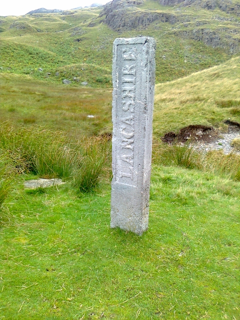
Three Shires Stone, Wrynose Pass
- Overview Map Street View The Three Shires Stone, at the top of Wrynose Pass near Little Langdale, marks the historic boundary of the old counties of Lancashire, Cumberland and Westmorland. …

Co-Curate Page
Ulverston Parish, 1848
- ULVERSTON (St. Mary), a market-town and parish, and the head of a union, in the hundred of Lonsdale north of the Sands, N. division of the county of Lancaster; containing, …
Co-Curate Page
Kirkby Ireleth Parish, 1848
- KIRKBY-IRELETH (St. Cuthbert), a parish, in the union of Ulverston, hundred of Lonsdale north of the Sands, N. division of the county of Lancaster, 4½ miles (N.W. by W.) from …
Co-Curate Page
Colton Parish, 1848
- Note the different spelling below (Coulton), compared to the current Colton. COULTON (Holy Trinity), a parish, in the union of Ulverston, hundred of Lonsdale north of the Sands, N. division …
Co-Curate Page
Cartmel Parish, 1848
- CARTMEL (St. Mary), a parish, in the union of Ulverston, hundred of Lonsdale north of the Sands, N. division of the county of Lancaster, containing 4,927 inhabitants: the town of …
Co-Curate Page
Aldingham Parish, 1848
- ALDINGHAM (St. Cuthbert), a parish, in the union of Ulverston, hundred of Lonsdale north of the Sands, N. division of the county of Lancaster, 5¾ miles (S.) from Ulverston; containing …
Co-Curate Page
Barrow in Furness, 1848
- BARROW, a village and sea-port, in the township of Hawcoat, parish of Dalton, union of Ulverston, hundred of Lonsdale north of the Sands, N. division of the county of Lancaster, …
Co-Curate Page
Dalton
- Overview About Dalton Map Street View DALTON, a township, in the parish of Burton-In-Kendal, hundred of Lonsdale south of the Sands, N. division of the county of Lancaster, ½ a …
Co-Curate Page
Hawkshead Parish, 1848
- HAWKSHEAD (St. Michael), a market-town and parish, in the union of Ulverston, hundred of Lonsdale north of the Sands, N. division of the county of Lancaster, 28 miles (N.N.W.) from …
Co-Curate Page
Dalton-In-Furness Parish, 1848
- DALTON-IN-FURNESS (St. Mary), a market town and parish, in the union of Ulverston, hundred of Lonsdale north of the Sands, N. division of the county of Lancaster, 5 miles (S.W.) …
Co-Curate Page
Urswick Parish, 1848
- URSWICK (St. Mary), a parish, in the union of Ulverston, hundred of Lonsdale north of the Sands, N. division of the county of Lancaster, 3 miles (S.W. by S.) from …


