Topics > Heritage Sites > Scheduled Monument > Scheduled Monuments in Newcastle
Scheduled Monuments in Newcastle
This page includes Scheduled Monuments in Newcastle upon Tyne.
Scheduled Monuments are sites of national significance which have been given the top-level of legal protection under the Ancient Monuments and Archaeological Areas Act 1979. They range from archaeological sites (prehistoric, Roman, Medieval etc) to ruins or surviving structures (including some 19th/20th century industrial and military sites).
Co-Curate Page
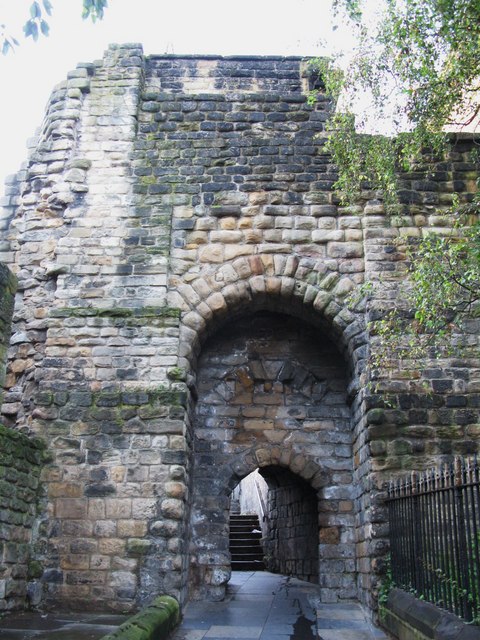
South Postern Tower, Newcastle Castle
- Overview Map Street View The south postern tower, from the outer walls of Newcastle Castle, is located on Castle Garth (road). The tower has a gateway leading on to Castle …
Co-Curate Page
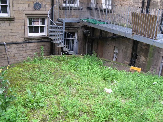
Durham Tower
- Overview Map Street View Durham Tower was built as part of Newcastle's Town Wall during the late 13th century. It was a single-storey semi-circular tower with a strong rib-vaulted room. The …
Co-Curate Page
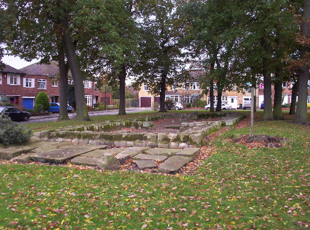
North Gosforth Chapel (ruins)
- Overview Map Street View Scheduled Monument area - based on Historic England data (Open Government Licence). The remains of the medieval chapel in North Gosforth were uncovered when the Melton …
Co-Curate Page
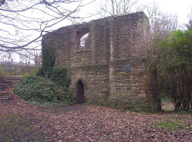
Morden Tower
- Overview About the Tower & Poetry Centre Map Morden Tower is a turret on the west section of the Town Walls in Newcastle dating from 1280. Eneas Mackenzie, wrote in …
Co-Curate Page
House of Adam of Jesmond
- Overview Map Street View The House of Adam in Heaton Park in Heaton dates back to at least 1267.[1] It was the camera (seat) of Adam de Gesmuth (Adam of Jesmond), …

Co-Curate Page
St Mary's Chapel
- Overview Map Street View Pilgrim Street in Newcastle is so named because of the many pilgrims traveling that way to St Mary's Chapel in Jesmond; "THERE was an Inn in …

Co-Curate Page
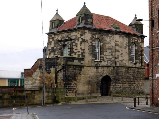
Heron Pit Prison and Drawbridge Pit, by Black Gate
- Barbican, prison and pits dating from the mid 13th and 17th century. Grade I listed. The information board by the pit states: "William Heron - The Hammer of the Poor …

Co-Curate Page
Gardner's Houses Prehistoric Settlement
- Scheduled Monument area to the north of Dinnington - based on Historic England data (Open Government Licence). There is evidence of a prehistoric settlement near Gardener's House Farm, which is located …
Co-Curate Page
Andrew Tower
- Overview Map Andrew Tower was a semi-circular stone tower built as part of the Town Walls during the late 13th century. "Andrew Tower evidently acquired its name from its vicinity …
Co-Curate Page
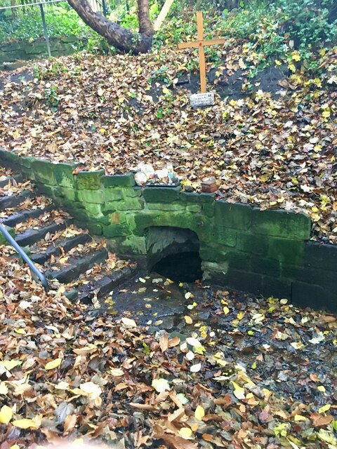
St Mary's Well, Jesmond
- Overview Map Street View St Mary's Well is located in a small fenced enclosure on the north side of The Grove in Jesmond. It as a holy well, probably dating …
Co-Curate Page
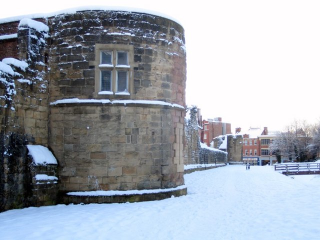
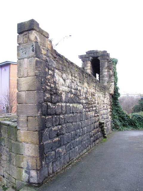
Corner Tower
- Overview Map Street View Corner Tower and a small upstanding section of the Town Wall are located off City Road, by Croft Stairs in Newcastle. This was different to the …
Co-Curate Page
Gunner Tower
- Overview Map Gunner Tower, on the Town Walls, was located on what is now Pink Lane in Newcastle. The Medieval tower was leased to the Company of Slaters and Tylers …
Co-Curate Page
Land Arch of the Medieval Tyne Bridge
- Two sandstone land arches of the Medieval Tyne Bridge in Newcastle survive. Part of one is visible, the remainder obscured by later building. They are accessible from the cellar of …
Co-Curate Page
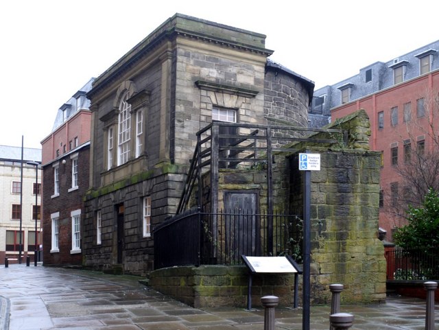
Plummer Tower
- Overview Map Street View Plummer Tower, located on what is now Croft Street, was part of Newcastle's Town Walls, built in the 13th and 14th century. During the Civil War, …
Co-Curate Page
Sallyport Tower
- Overview Map Street View Sallyport Tower (aka Wallknoll Tower). In 1827 Eneas Mackenzie wrote: "Wall Knoll Tower, now called Carpenters' Tower, because the company of Carpenters or Shipwrights meet in it, …
Co-Curate Page
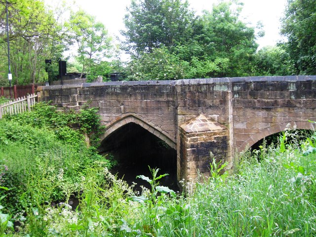
Salters Bridge
- Overview Map Street View Salters Bridge crosses the Ouseburn in South Gosforth. It dates from the 14th Century and is Grade I listed on the National Heritage List for England …
Co-Curate Page
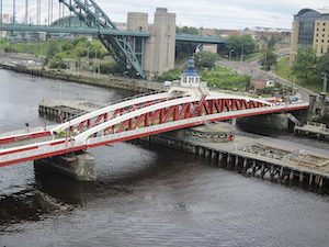
Newcastle Swing Bridge
- Overview Further Information Map Street View The Swing Bridge over the River Tyne was first used for road traffic on 15th June 1876 and opened for river traffic on 17th …

Co-Curate Page
Dewley Hill round barrow
- Scheduled Monument area - based on Historic England data (Open Government Licence). Dewley Hill - photo by Andrew Curtis, CC-BY-SA Scheduled Monument (#1018678): Dewley Hill round barrow and associated features, …
Co-Curate Page
Dewley Pits, SW of Black Callerton
- Scheduled Monument areas (7) - based on Historic England data (Open Government Licence). Scheduled Monument (#1016194): Coal workings at Dewley Pits, 650m south west of Black Callerton Click the headings …

Co-Curate Page
Iron Age / Romano-British settlement, Hazlerigg
- Scheduled Monument area - based on Historic England data (Open Government Licence). To the south of Hezlerigg in Newcastle are the sites of two enclosed settlements of late Iron Age …

Co-Curate Page
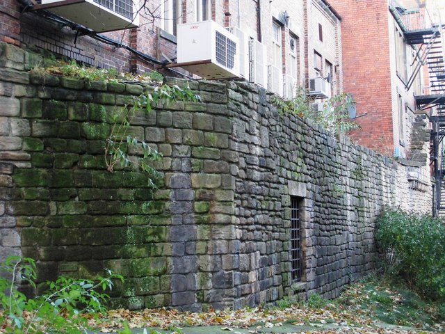
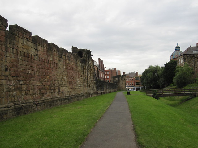
Town Wall section near Hanover Street
- Scheduled Monument area - based on Historic England data (Open Government Licence). This Scheduled Monument is a section of the Town Wall which stretch between Hanover Street and the River …
Co-Curate Page
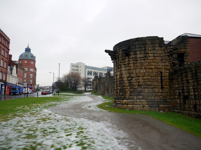
Section of Town Wall containing Ever, Morden and Heber towers
- Scheduled Monument area - based on Historic England data (Open Government Licence). The best preserved section of Newcastle's Medieval Town Wall stretches from St Andrew's Street to Bath Lane, running …

Co-Curate Page
South Postern Tower, Newcastle Castle
- Overview Map Street View The south postern tower, from the outer walls of Newcastle Castle, is located on Castle Garth (road). The tower has a gateway leading on to Castle …
Co-Curate Page
Durham Tower
- Overview Map Street View Durham Tower was built as part of Newcastle's Town Wall during the late 13th century. It was a single-storey semi-circular tower with a strong rib-vaulted room. The …
Co-Curate Page
North Gosforth Chapel (ruins)
- Overview Map Street View Scheduled Monument area - based on Historic England data (Open Government Licence). The remains of the medieval chapel in North Gosforth were uncovered when the Melton …
Co-Curate Page
Morden Tower
- Overview About the Tower & Poetry Centre Map Morden Tower is a turret on the west section of the Town Walls in Newcastle dating from 1280. Eneas Mackenzie, wrote in …
Co-Curate Page
House of Adam of Jesmond
- Overview Map Street View The House of Adam in Heaton Park in Heaton dates back to at least 1267.[1] It was the camera (seat) of Adam de Gesmuth (Adam of Jesmond), …
Co-Curate Page
St Mary's Chapel
- Overview Map Street View Pilgrim Street in Newcastle is so named because of the many pilgrims traveling that way to St Mary's Chapel in Jesmond; "THERE was an Inn in …
Co-Curate Page
Heron Pit Prison and Drawbridge Pit, by Black Gate
- Barbican, prison and pits dating from the mid 13th and 17th century. Grade I listed. The information board by the pit states: "William Heron - The Hammer of the Poor …
Co-Curate Page
Gardner's Houses Prehistoric Settlement
- Scheduled Monument area to the north of Dinnington - based on Historic England data (Open Government Licence). There is evidence of a prehistoric settlement near Gardener's House Farm, which is located …
Co-Curate Page
Andrew Tower
- Overview Map Andrew Tower was a semi-circular stone tower built as part of the Town Walls during the late 13th century. "Andrew Tower evidently acquired its name from its vicinity …
Co-Curate Page
St Mary's Well, Jesmond
- Overview Map Street View St Mary's Well is located in a small fenced enclosure on the north side of The Grove in Jesmond. It as a holy well, probably dating …
Co-Curate Page
Corner Tower
- Overview Map Street View Corner Tower and a small upstanding section of the Town Wall are located off City Road, by Croft Stairs in Newcastle. This was different to the …
Co-Curate Page
Gunner Tower
- Overview Map Gunner Tower, on the Town Walls, was located on what is now Pink Lane in Newcastle. The Medieval tower was leased to the Company of Slaters and Tylers …
Co-Curate Page
Land Arch of the Medieval Tyne Bridge
- Two sandstone land arches of the Medieval Tyne Bridge in Newcastle survive. Part of one is visible, the remainder obscured by later building. They are accessible from the cellar of …
Co-Curate Page
Plummer Tower
- Overview Map Street View Plummer Tower, located on what is now Croft Street, was part of Newcastle's Town Walls, built in the 13th and 14th century. During the Civil War, …
Co-Curate Page
Sallyport Tower
- Overview Map Street View Sallyport Tower (aka Wallknoll Tower). In 1827 Eneas Mackenzie wrote: "Wall Knoll Tower, now called Carpenters' Tower, because the company of Carpenters or Shipwrights meet in it, …
Co-Curate Page
Salters Bridge
- Overview Map Street View Salters Bridge crosses the Ouseburn in South Gosforth. It dates from the 14th Century and is Grade I listed on the National Heritage List for England …
Co-Curate Page
Newcastle Swing Bridge
- Overview Further Information Map Street View The Swing Bridge over the River Tyne was first used for road traffic on 15th June 1876 and opened for river traffic on 17th …
Co-Curate Page
Dewley Hill round barrow
- Scheduled Monument area - based on Historic England data (Open Government Licence). Dewley Hill - photo by Andrew Curtis, CC-BY-SA Scheduled Monument (#1018678): Dewley Hill round barrow and associated features, …
Co-Curate Page
Dewley Pits, SW of Black Callerton
- Scheduled Monument areas (7) - based on Historic England data (Open Government Licence). Scheduled Monument (#1016194): Coal workings at Dewley Pits, 650m south west of Black Callerton Click the headings …
Co-Curate Page
Iron Age / Romano-British settlement, Hazlerigg
- Scheduled Monument area - based on Historic England data (Open Government Licence). To the south of Hezlerigg in Newcastle are the sites of two enclosed settlements of late Iron Age …
Co-Curate Page
Town Wall section near Hanover Street
- Scheduled Monument area - based on Historic England data (Open Government Licence). This Scheduled Monument is a section of the Town Wall which stretch between Hanover Street and the River …


