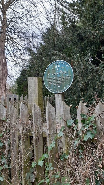
Topics > Tyne and Wear > Newcastle upon Tyne > Jesmond > St Mary's Well, Jesmond
St Mary's Well, Jesmond
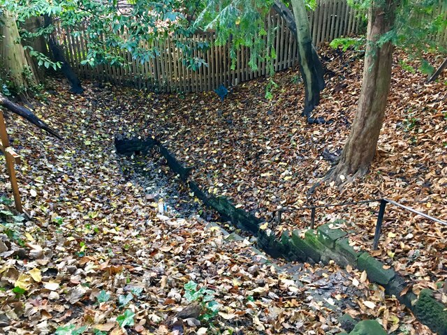
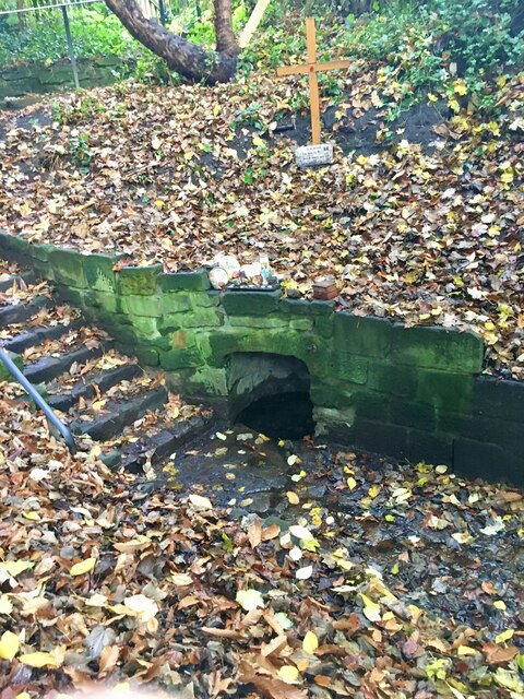
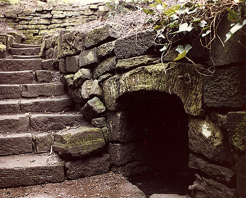
St Mary's Well is located in a small fenced enclosure on the north side of The Grove in Jesmond. It as a holy well, probably dating from the 17th century, possibly earlier. A bath structure to the north west of the well was added in the early 18th century by William Coulson. It was enclosed in the 19th century. The well is associated with the close by St Mary's Chapel, which was a place of pilgrimage in the medieval period. As such, it is possible that there was an early well here, pre-dating the stone structures built in the 17th/18th century. St Mary's Well was restored in 1982. The site is a Scheduled Monument (legally protected).
Scheduled Monument (#1018641): St Mary's Well, Jesmond
Click the headings below to expand (selected extracts from the Historic England scheduling)
Holy wells are water sources with specifically Christian associations. The custom of venerating springs and wells as sacred sites is also known to have characterised pre-Christian religions in Britain and, although Christian wells have been identified from as early as the 6th century AD, it is clear that some holy wells originated as earlier sacred sites.
St Mary's Well is a well preserved example of this class of monument and is believed to date from the 17th century, although it may have origins in the medieval period. It is associated as a place of pilgrimage with St Mary's Chapel, the subject of a separate scheduling.
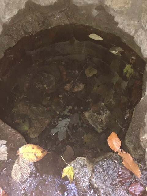
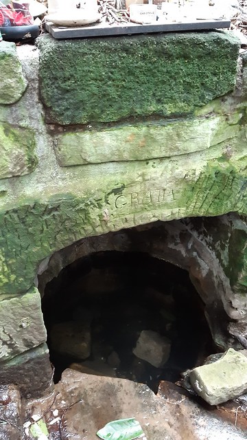
The monument includes St Mary's Well, situated in a fenced enclosure, 100m west of St Mary's Chapel, Jesmond. The visible remains, which are Listed Grade II, include a well, a flagstone paved area enclosed by walls, and steps leading down to the well from the south.
The well is circular in plan. The lowest three courses of the well lining are of dressed sandstone blocks with curved inner faces and packed with pink-brown clay. These courses are lain on top of a millstone base. Above these are three uneven courses of roughly dressed stone. The well lining is surmounted by a capstone, which has 'gratia' carved on it. The presence of two iron hinges to the right of the well opening and the stub of a retaining bar on the left indicate that the well opening was at one time enclosed by a door. The area of flagstones starts at the foot of the steps, in front of the well opening, and extends to the north. The area of flagstones is approximately 6m in length from the steps to the north wall, and in width it tapers from 1.5m next to the well opening to 1.1m at the northern end. The flagstones in front of the well opening are larger than the area to the north and have been shaped to abut neatly with each other. The area to the north has been lain with smaller flagstones and cobbles in an irregular pattern. The area of flagstones is enclosed by walls on three sides: west, north and east. The west wall stands to a height of 1.5m at its southern end and decreases in height to 0.5m where it joins the north wall. The north and east wall are to 0.5m high. Part of the east wall is one course lower and provides a seat. The steps lead down in a zigzag pattern, into the hollow from the south- west corner of the enclosure. The first edition Ordnance Survey 1:2500 map shows that the steps led straight down into the hollow from the south. This map also shows an access path coming in from the north.
The well has been the subject of a partial excavation prior to restoration in 1982, which identified four phases of construction. Phase one relates to the lower three courses of the well lining and the area of large flags immediately in front of the well opening and has been dated to the 17th century by brick fragments. The second phase saw the addition of a bath structure to the north west of the well by William Coulson in the early 18th century. This is not visible but will be preserved beneath the surface. The third phase, dated to the early 19th century, includes the enclosing of the well with the addition of the upper courses of the well-lining, capstone and door. Associated with this phase is the demolition of the bath, and the foundation courses of the west wall. The fourth phase is the erection of the east and west walls and the extension of the cobbled area to its present form.
Though the first historical reference to the well is in the 18th century and the present structure is believed to date from the 17th century, it is thought that there may have been a well of greater antiquity associated with St Mary's Chapel, which was a place of pilgrimage in the medieval period.


from https://historicengland.org.u…
ST MARY'S WELL - Jesmond - List Entry
- "Well and bathing place. Possibly late C17 well; C18 bathing place; C19 restoration. Sandstone, some coursed and squared, some blocks ashlar-dressed. Steps down to nearly-rectangular bathing place with walls from …
Added by
Simon Cotterill

from https://www.twsitelines.info/…
Tyne and Wear HER(146): Jesmond, St. Mary's Well
- "The first reference to the well is 18th century and it seems likelly that it originated in the post-medieval period rather than as a medieval holy well, as has also …
Added by
Simon Cotterill

from Newcastle libraries (flickr)
037188:St. Mary's Well Jesmond City Engineers 1978
Pinned by Peter Smith

from https://historicengland.org.u…
ST MARY'S WELL - Jesmond - List Entry
- "Well and bathing place. Possibly late C17 well; C18 bathing place; C19 restoration. Sandstone, some coursed and squared, some blocks ashlar-dressed. Steps down to nearly-rectangular bathing place with walls from …
Added by
Simon Cotterill
from https://www.twsitelines.info/…
Tyne and Wear HER(146): Jesmond, St. Mary's Well
- "The first reference to the well is 18th century and it seems likelly that it originated in the post-medieval period rather than as a medieval holy well, as has also …
Added by
Simon Cotterill
from Newcastle libraries (flickr)
037188:St. Mary's Well Jesmond City Engineers 1978
Pinned by Peter Smith


