Topics > Heritage Sites > Newcastle Town Walls > Sallyport Tower
Sallyport Tower
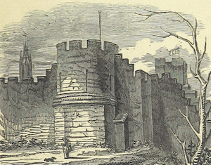
 Sallyport Tower (aka Wallknoll Tower). In 1827 Eneas Mackenzie wrote: "Wall Knoll Tower, now called Carpenters' Tower, because the company of Carpenters or Shipwrights meet in it, "was," says Bourne, "one of the towers of the Old Romans. This company, in the year 1716, built upon the under part of it a very grand and stately square tower, adorned at the top corners with 4 fair turrets, built in the form of a lanthorn." He adds, on the authority of a MS. intitled, "Lib. de Reb. Novocastri," that, "before the taking down of the top of the old tower, it was much of the same size, model, and stone, with the tower of Routchester, in Northumberland, which was certainly one of the towers belonging to the Picts-Wall." The ancient postern gate in this tower was the usual passage of those divisions of the garrison that so frequently sallied out, and attacked the besieging army during the civil wars. It is probably from this circumstance that it is called the Sally-Port Gate."
Scheduled Monument (#1019811): Newcastle upon Tyne town defences: section of curtain wall including Sallyport or Wall Knoll Tower
Click the headings below to expand (selected extracts from the Historic England scheduling)
Given the role played by the town defences in one of England's major commercial towns and their contribution towards an understanding of medieval and later urban development, all sections of Newcastle's town defences that exhibit significant archaeological remains are considered to be nationally important. Despite the fact that the standing and buried remains of the medieval town wall on the west side of Tower Street have been incorporated within an early 18th century building, they survive reasonably well to a height of more than 3.5m. The length of curtain wall containing Sallyport or Wall Knoll Tower and a lesser gateway is a rare survival, being one of few remaining locations, particularly on the east side of the circuit, where the curtain wall and its associated structures remain. They will add greatly to our understanding of how the defences of Newcastle upon Tyne were constructed and operated.
The monument is situated in an elevated position on the west side of Tower Street at the junction of Tower Street and Garth Heads. It includes the upstanding and buried remains of part of the town defences of Newcastle upon Tyne. The section of town defences on the west side of Tower Street represents part of the eastern side of the circuit and includes a length of curtain wall, a tower and one of the town's lesser gateways. The curtain wall, tower and gateway are a Listed Building Grade I. Further sections of the town defences to the north and south are the subject of separate schedulings.
Newcastle upon Tyne's town defences were constructed from the mid-13th century to the middle or late 14th century enclosing an area of more than 60ha; the riverside lengths of curtain wall were added during the 15th century. The masonry defences were strengthened by a berm and a ditch, except on the south side where they were bounded by the River Tyne. Gateways were built at the principal points of entry to the town. Internally, a cobbled inter mural lane followed the line of the defences. The defences were refurbished during the medieval period and were reinforced and repaired several times during the post-medieval period.
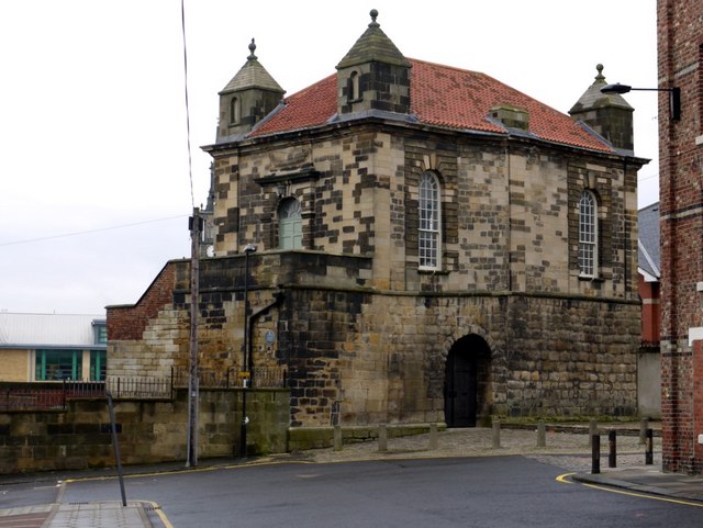
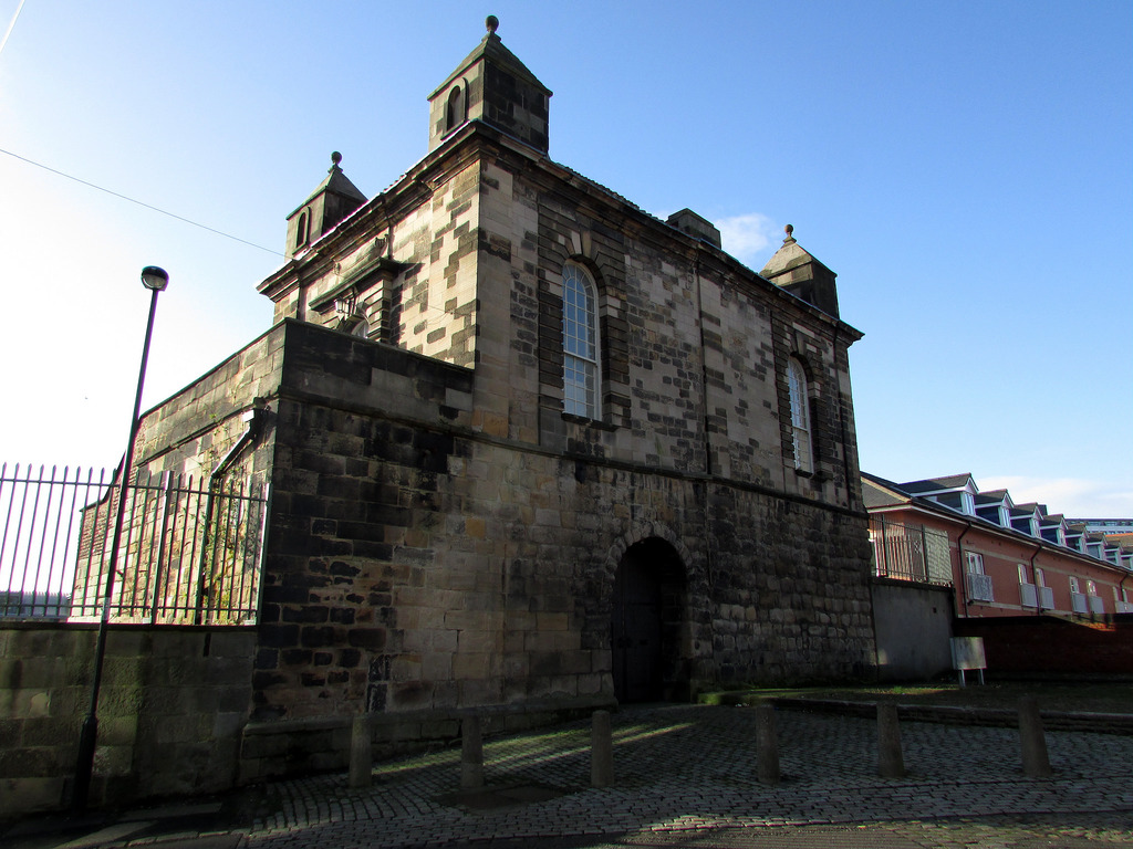
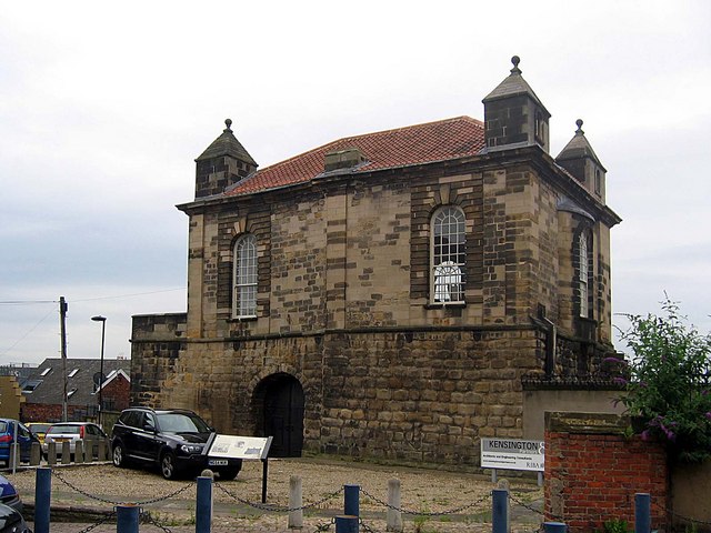
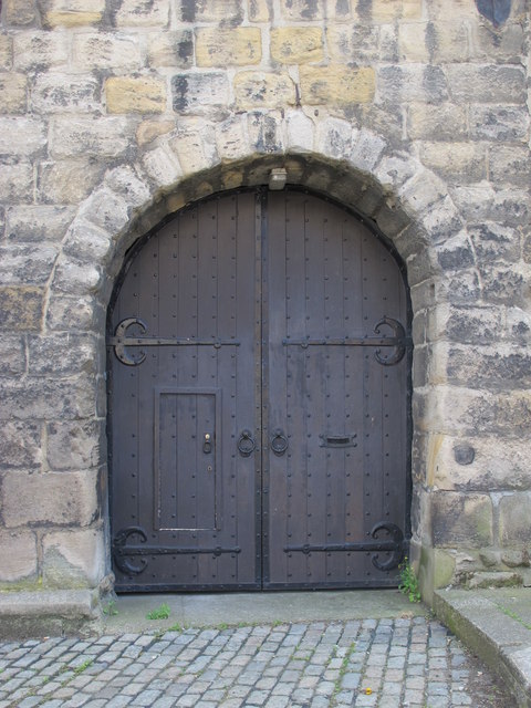
The length of curtain wall in this section, constructed of large sandstone blocks and, divided into two parts by the tower, stands to a maximum height of 4.5m at its western end. The most westerly fragment, attached to the south west corner of the tower is 1.5m long; this fragment formed the eastern end of a small rectangular chamber located within the thickness of the curtain wall. Access to the chamber was gained through an arched doorway from a spiral staircase located within the south west corner of the tower. Attached to the south eastern corner of the tower the more easterly length of curtain wall is about 5.5m long and 2.1m wide. This length of wall contains a single round- headed entrance passage 2.9m wide known as Sallyport which formed one of the lesser gateways of the town wall circuit.
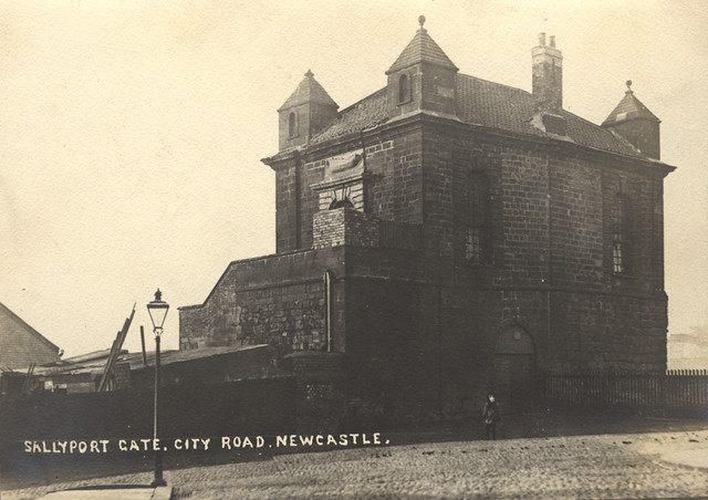
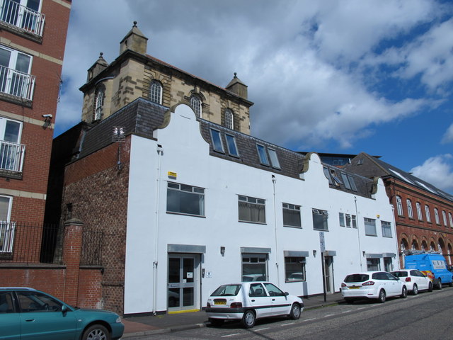
Projecting forwards from the outer face of the curtain wall there is a tower known as Sallyport or Wall Knoll Tower. The tower is visible as a rectangular structure 8.5m north east to south west by 7.8m and constructed of coursed squared sandstone blocks. Originally of only one storey, the medieval masonry stands to a maximum height of 3.6m. Narrow window loops, now blocked, are contained within the three outer faces of the tower. Within the tower the ground floor chamber is covered by a stone vault and is unusual in having a spiral stair which rises from the south west corner of the chamber to the former wall walk. The tower was leased to the Company of Shipwrights at least as early as 1638 and was modified in 1716 when an upper chamber was added to the top of the tower and a second bay was added to the east.

from Newcastle libraries (flickr)
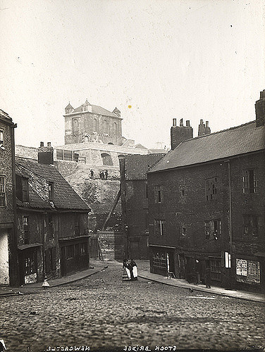
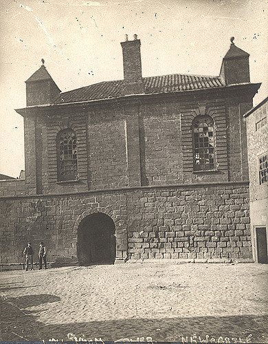
003829:Sallyport Tower Newcastle upon Tyne Unknown 1879-80
Pinned by Simon Cotterill
from Newcastle libraries (flickr)
012028:Sallyport Tower Newcastle upon Tyne Unknown 1900
Pinned by Simon Cotterill

from http://twsitelines.info/SMR/1…
Tyne and Wear HER(1562): Newcastle town wall, Wallknoll or Sallyport Tower
- "Walknoll, Sallyport or (Ships) Carpenters' Tower was presumably that which caused the emigration of the Carmelite Friars at the beginning of the 14th century. It was originally a rectangular tower, …
Added by
Simon Cotterill

from https://historicengland.org.u…
SALLYPORT OR WALL KNOLL TOWER - Newcastle - List Entry
- "Lesser gateway in Town Wall; Company of Ship's Carpenter's meeting hall above. C14 Town wall; 1716 meeting hall. Coursed squared sandstone wall; sandstone ashlar hall with pantiled roof. 2 storeys, …
Added by
Simon Cotterill

from Newcastle libraries (flickr)
003829:Sallyport Tower Newcastle upon Tyne Unknown 1879-80
Pinned by Simon Cotterill
from Newcastle libraries (flickr)
012028:Sallyport Tower Newcastle upon Tyne Unknown 1900
Pinned by Simon Cotterill
from http://twsitelines.info/SMR/1…
Tyne and Wear HER(1562): Newcastle town wall, Wallknoll or Sallyport Tower
- "Walknoll, Sallyport or (Ships) Carpenters' Tower was presumably that which caused the emigration of the Carmelite Friars at the beginning of the 14th century. It was originally a rectangular tower, …
Added by
Simon Cotterill
from https://historicengland.org.u…
SALLYPORT OR WALL KNOLL TOWER - Newcastle - List Entry
- "Lesser gateway in Town Wall; Company of Ship's Carpenter's meeting hall above. C14 Town wall; 1716 meeting hall. Coursed squared sandstone wall; sandstone ashlar hall with pantiled roof. 2 storeys, …
Added by
Simon Cotterill


List number: 1121526
Tyne & Wear HER: 1562
Post code: NE1 2HY
Borough: Newcastle
Grid ref: NZ2547464148


