Topics > Heritage Sites > Newcastle Town Walls > Corner Tower
Corner Tower
![]()
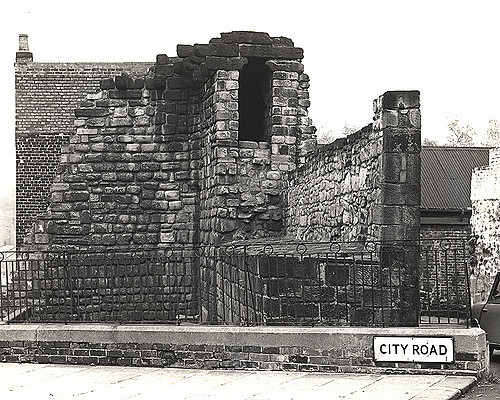
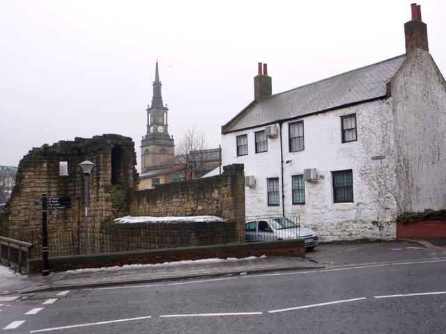
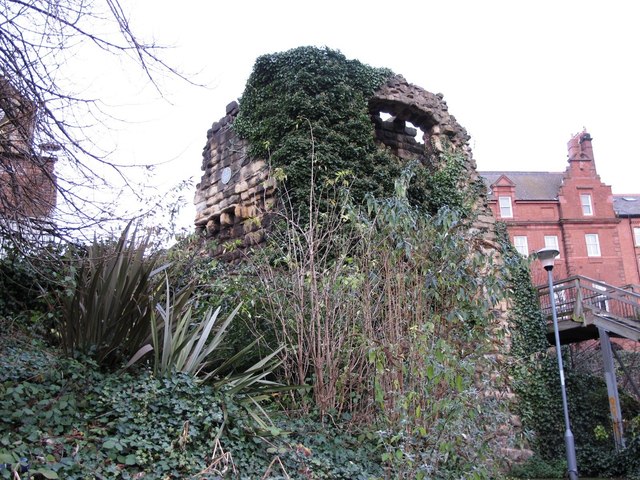
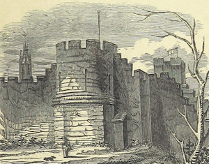
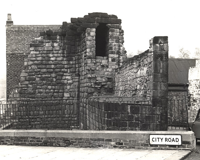 Corner Tower and a small upstanding section of the Town Wall are located off City Road, by Croft Stairs in Newcastle. This was different to the other semi-circular towers of the Town Wall, having two turrets standing to roof height set at right-angles to one another.
It is thought that the corner design resulted from Newcastle's acquisition of Pandon by Edward I's charter of 1299, which required a change in direction of the wall here. The tower and wall has stepped foundations in order to facilitate its steep descent to the valley of the former Pandon Burn. The remains of the tower and small section of the walls can still be seen. The tower and adjacent section of wall is Grade I listed on the National Heritage List for England and also a Scheduled Ancient Monument.
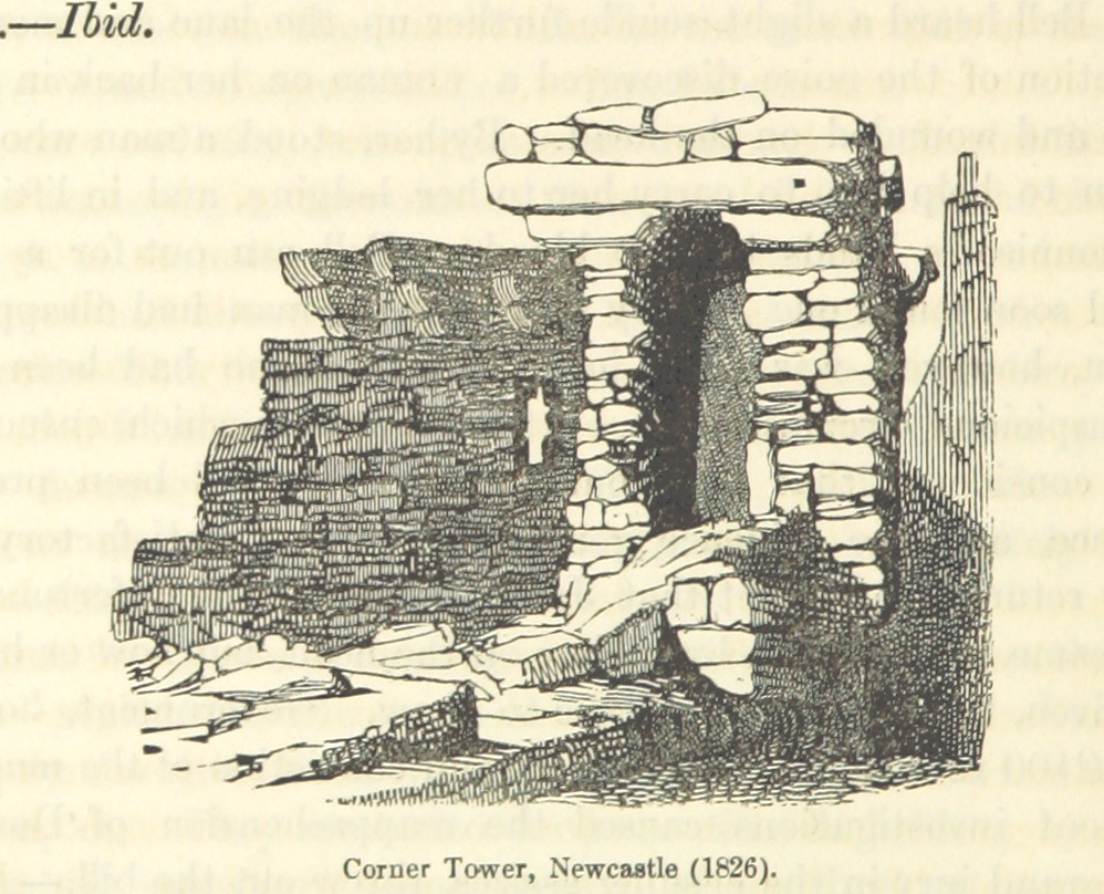
Corner Tower is probably so called from being in an angle of the wall. It is mentioned in the common council books, June 9, 1688, by the name of "Corn-Hill Tower;" an evident corruption of Corner Tower. It stood in a commanding situation, but is now in ruins.
Extract from Eneas Mackenzie, Historical Account of Newcastle-Upon-Tyne Including the Borough of Gateshead. Mackenzie and Dent, Newcastle-upon-Tyne, 1827.
Scheduled Monument (#1019810): Newcastle upon Tyne town defences: section of curtain wall containing Corner Tower
Click the headings below to expand (selected extracts from the Historic England scheduling)
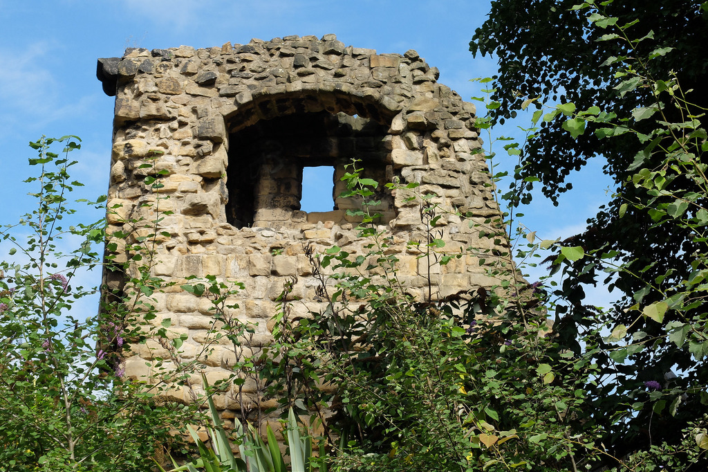
The standing remains of the medieval curtain wall between Croft Stairs and City Road survive well. They are a rare survival being one of few remaining locations, particularly on the east side of the circuit, where the curtain wall and its associated structures remain upstanding and visible. In one place the remains stand to the full height of the parapet. The tower is of particular importance as unusually it comprises two conjoined turrets to form a change of angle in the line of the defences.
The turret is unusual in being the only known example to project north of the curtain wall. As a monument which is partially accessible to the public, this section of Newcastle's town defences serves as an important educational and recreational resource which will increase our understanding of how Newcastle's defences developed.
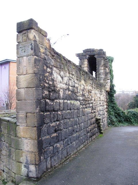
The monument is situated on the south side of City Road, immediately to the east of Croft Stairs above the steep slopes of the former Pandon Burn. It includes the upstanding and buried remains of part of the town defences of Newcastle upon Tyne. The section of town defences between City Road and Croft Stairs represent part of the eastern side of the circuit and include an `L'-shaped section of curtain wall, a tower comprising two conjoined turrets and a single turret. Corner Tower and the curtain wall are also a Listed Building Grade I. Further sections of the town defences are the subject of separate schedulings.
Newcastle upon Tyne's defences were constructed from the mid-13th century to the middle or late 14th century and enclosed an area of more than 60ha; the riverside lengths of wall were added during the 15th century. The masonry defences were strengthened by a berm and ditch, except on the south side, where they were bounded by the River Tyne. Gateways were built at the principal points of entry to the town. Internally, a cobbled inter-mural lane followed the line of the defences. The defences were refurbished during the medieval period and were reinforced and repaired several times during the post-medieval period.
The tower, known as Corner Tower, sits at the angle of an `L'-shaped section of the curtain wall. It comprises two conjoined wall turrets to form a right angled structure with projecting corbels on its inner face. This unusually shaped tower was constructed between 1299 and 1307 in order to facilitate a change of angle in the town defences to include within their circuit the suburb of Pandon, granted to the town in 1298. The tower stands to a maximum height of about 10m and, `L'-shaped in plan, is constructed of large blocks of coursed, square sandstone. A short fragment of walling 2.5m wide, attached to the south wall of the tower is thought to be the remains of an internal buttress which stood to an original height of 4m. Attached to the north and the east sides of the tower there are lengths of curtain wall. The first, at the northern end of the tower is 10m long and stands to a maximum height of 4m; the inner face of this wall stands several metres above the remainder of the wall and is thought to be a post-medieval addition.
The outer, eastern face of the curtain wall contains a single chamfer course above two offset courses. On the outer, northern face of the wall near its junction with the north end of the tower, there are the lower parts of a projecting flight of stone steps which originally gave access to the wall walk. The second length of curtain wall attached to the east side of the tower is 31m long and on average 2.1m wide. It is constructed of coursed sandstone blocks and has stepped foundations in order to facilitate its steep descent to the former Pandon Burn. This section of curtain wall was constructed in three different phases indicating that during its construction it underwent a change of plan which included the addition of a turret. The easternmost 12.8m of this length of curtain wall stands to the full height of the original parapet walkway and also retains the lower parts of the medieval parapet; the upper parts of the parapet are thought to have been added in the 19th century.
At the extreme eastern end of this section of curtain wall there are the remains of a turret. On the inner face of the wall the turret is visible as a row of seven closely spaced projecting corbels; a layer of flagstones supported by the three most easterly corbels indicate that the turret was carried over the wall walk. Part of an arrow loop is visible in the north face of the turret. This turret is unique on the defensive circuit as it projects forward from the face of the curtain wall some 0.5m.
Partial excavation immediately to the south of Corner Tower in 1978 found that the tower did not replace an earlier defensive line and that the decision to include Pandon within the defences therefore occurred before the wall in this area had been constructed. The excavation also uncovered a short section of cobbled roadway associated with 14th century pottery immediately to the south of Corner Tower; this is interpreted as the remains of the inter-mural lane.
Scheduled Monument area - based on Historic England data (Open Government Licence).
from Newcastle libraries (flickr)
014766:Corner Tower City Road Newcastle upon Tyne 1965
Pinned by Simon Cotterill

from http://twsitelines.info/SMR/1…
Tyne and Wear HER(1557): Newcastle town wall, Corner Tower
- "Not a tower of the usual type, but two turrets standing to roof height set at right-angles to one another on the eastern re-entrant of the curtain. It must be …
Added by
Simon Cotterill
from https://openlibrary.org/works…
An historical, topographical, and descriptive view of the county of Northumberland. (Eneas Mackenzie, 1825)
- Digitised version of An historical, topographical, and descriptive view of the county of Northumberland and of those parts of the county of Durham situated north of the river Tyne, with …
Added by
Simon Cotterill
from Newcastle libraries (flickr)
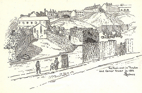
003757:Town Wall and Corner Tower Pandon Holmes S. 1882
Pinned by Simon Cotterill

from Newcastle libraries (flickr)
014766:Corner Tower City Road Newcastle upon Tyne 1965
Pinned by Simon Cotterill
from http://twsitelines.info/SMR/1…
Tyne and Wear HER(1557): Newcastle town wall, Corner Tower
- "Not a tower of the usual type, but two turrets standing to roof height set at right-angles to one another on the eastern re-entrant of the curtain. It must be …
Added by
Simon Cotterill
from https://openlibrary.org/works…
An historical, topographical, and descriptive view of the county of Northumberland. (Eneas Mackenzie, 1825)
- Digitised version of An historical, topographical, and descriptive view of the county of Northumberland and of those parts of the county of Durham situated north of the river Tyne, with …
Added by
Simon Cotterill
from Newcastle libraries (flickr)
003757:Town Wall and Corner Tower Pandon Holmes S. 1882
Pinned by Simon Cotterill

")


