Topics > Heritage Sites > Newcastle Town Walls > Andrew Tower
Andrew Tower
![]()
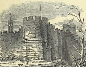
 Andrew Tower was a semi-circular stone tower built as part of the Town Walls during the late 13th century. "Andrew Tower evidently acquired its name from its vicinity to St. Andrew's church. At the west end of this tower, a wide opening was made in the wall in 1810, and called Heron Street." (Eneas Mackenzie, 1827) The vaulted ground floor room had for many years, been used as a charnel house (a vault used to store the bones of the deceased) - this was demolished in 1818 with parts of the town wall, to enlarge the burying area. Some of the remains of the wall and tower can still be seen in the churchyard and are Grade I listed on the National Heritage List for England, and also a Scheduled Ancient Monument (legally protected).
Scheduled Monument (#1019281): Newcastle upon Tyne town defences: section of curtain wall including St Andrew's Tower and section of town ditch
Click the headings below to expand (selected extracts from the Historic England scheduling)
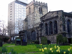
The standing remains of the medieval curtain wall in St Andrew's churchyard survive well to the height of the parapet walkway. The two lengths of curtain wall including the remains of three turrets are a rare survival, being one of few remaining locations where the curtain wall and its associated structures remain upstanding and highly visible. Taken together with the buried remains of curtain wall and St Andrew's Tower, they represent the second most complete lengths of the circuit. The buried remains of the berm and ditch represent one of few remaining locations where they are thought to survive. As a monument which is accessible to the public, this section of Newcastle town defences serves as an important educational and recreational resource which will increase our understanding of how Newcastle's defences developed.
The monument is situated within St Andrew's churchyard between St Andrew's Street and Newgate Street. It includes the upstanding and buried remains of part of the town defences of Newcastle upon Tyne. The section of town defences between St Andrew's Street and Newgate Street represents part of the northern side of the circuit and includes two detached upstanding lengths of curtain wall including the remains of three turrets, the buried remains of a length of curtain wall and the buried remains of a tower. Outside of the wall there are the buried remains of parts of the berm and town ditch. The two upstanding lengths of town wall and the turrets are Listed Buildings Grade I. Further sections of the town defences to the south west and the east are the subject of separate schedulings.
Newcastle upon Tyne town defences were constructed from the mid-13th century to the middle or late 14th century and enclosed an area of more than 60ha; the riverside lengths of curtain wall were added during the 15th century. The masonry defences were strengthened by a berm and ditch, except on the south side, where they were bounded by the River Tyne. Gateways were built at the principal points of entry to the town. Internally a cobbled inter-mural lane followed the line of the defences. The defences were refurbished during the medieval period and were reinforced and repaired several times during the post-medieval period. The curtain wall within St Andrew's churchyard was refurbished after the siege of Newcastle in 1644 when the town wall and St Andrew's Church were bombarded by Scottish artillery fire.
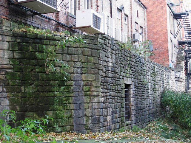
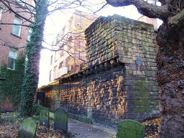
The first and most easterly upstanding length of curtain wall is 70m long and its inner face stands to a maximum height of 3m; its outer face has become incorporated into the adjacent brick buildings of numbers 1 to 25 Gallowgate. The wall is constructed of large sandstone blocks and at the eastern end it tapers from the bottom upwards to about half its thickness. At the western end of this length of wall there is a vaulted niche of uncertain nature and date and the internal face of a turret is visible standing 12 courses high. The turret retains the lower parts of its external staircase supported on a series of nine corbels which project from the inner face of the wall walk; the remainder of the turret has been incorporated into the adjacent brick building.
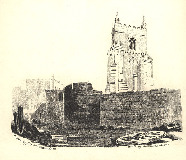
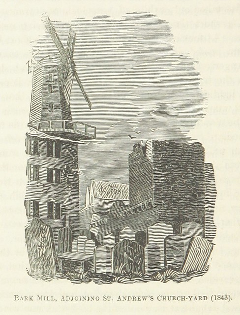
The most westerly upstanding length of town wall is 33m long, and its inner face stands to a maximum height of 4m above the present level of the ground. It retains the lower courses of the parapet and parts of the flagged paving of the walkway. The outer face of the wall is partly incorporated into the rear of numbers 43 to 47 Gallowgate although a 12m length of it is visible within the yard at the rear of 43 Gallowgate, standing 3.1m high including the lower courses of the parapet. This length of walling contains the remains of two turrets. The first is situated at the extreme eastern end of the length of wall and is 12 courses high; the remains of its external staircase supported on a series of corbels which project from the inner face of the wall are also visible. An area of consolidated rubble walling upon the parapet walkway at the extreme western end of this section of wall is interpreted as the remains of a second turret. In 1995 a partial excavation at the western end of the most westerly length of curtain wall took place at Ordnance Survey NGR NZ24476438. The excavation, which examined the area at the foot of the inner face, demonstrated that the curtain wall in this area was built in two separate phases with several decades between them. During the first phase the curtain wall was constructed directly onto the sub-soil with foundations composed of a projecting course of roughly dressed sandstone blocks, laid flat. The lower courses of the curtain wall above the foundations were of large squared sandstone blocks bonded with mortar. The second phase of construction, keyed onto the south end of the first, did not have a projecting foundation courses and was built of more irregular sandstone. The total height of the curtain wall from foundation level to the parapet walk was 5.7m. The excavations also demonstrated the survival of deep medieval and later deposits below the present ground level. Between the two upstanding lengths of curtain wall there are the buried remains of the curtain wall and a tower known as St Andrew's Tower. These features were dismantled and their foundations buried between 1827 and 1830 when the churchyard expanded northwards; an etching of the tower dated 1818 shows that it was single storey and had not been altered by later modifications.
Scheduled Monument area - based on Historic England data (Open Government Licence).
from Newcastle libraries (flickr)
003771:Andrew Tower Newcastle upon Tyne Richardson T.M. 1825?
Pinned by Simon Cotterill

from http://www.twsitelines.info/s…
Tyne and Wear HER(1541): Newcastle town wall, Andrew Tower
- "The two available illustrations show this tower to have resembled the others on the west side of the defences, i.e. semi-circular, with oversailing corbels on the exterior, a crenellated parapet, …
Added by
Simon Cotterill

from Flickr (flickr)
Image taken from page 712 of 'The Local Historian's Table Book of remarkable occurrences, historical facts, traditions, legendary and descriptive ballads, connected with the Counties of Newcastle-upon-Tyne, Northumberland, and Durham. Historical Division.
Pinned by Simon Cotterill

from https://historicengland.org.u…
Newcastle upon Tyne town defences: section of curtain wall including St Andrew's Tower and section of town ditch
- "The monument is situated within St Andrew's churchyard between St Andrew's Street and Newgate Street. It includes the upstanding and buried remains of part of the town defences of Newcastle …
Added by
Simon Cotterill

from Newcastle libraries (flickr)
003771:Andrew Tower Newcastle upon Tyne Richardson T.M. 1825?
Pinned by Simon Cotterill
from http://www.twsitelines.info/s…
Tyne and Wear HER(1541): Newcastle town wall, Andrew Tower
- "The two available illustrations show this tower to have resembled the others on the west side of the defences, i.e. semi-circular, with oversailing corbels on the exterior, a crenellated parapet, …
Added by
Simon Cotterill
from Flickr (flickr)
Image taken from page 712 of 'The Local Historian's Table Book of remarkable occurrences, historical facts, traditions, legendary and descriptive ballads, connected with the Counties of Newcastle-upon-Tyne, Northumberland, and Durham. Historical Division.
Pinned by Simon Cotterill
from https://historicengland.org.u…
Newcastle upon Tyne town defences: section of curtain wall including St Andrew's Tower and section of town ditch
- "The monument is situated within St Andrew's churchyard between St Andrew's Street and Newgate Street. It includes the upstanding and buried remains of part of the town defences of Newcastle …
Added by
Simon Cotterill