Topics > Heritage Sites > Newcastle Town Walls > Section of Town Wall containing Ever, Morden and Heber towers
Section of Town Wall containing Ever, Morden and Heber towers
Scheduled Monument area - based on Historic England data (Open Government Licence).
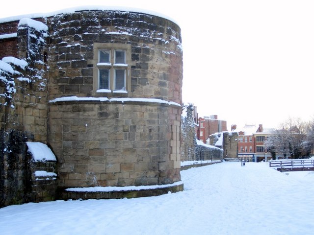
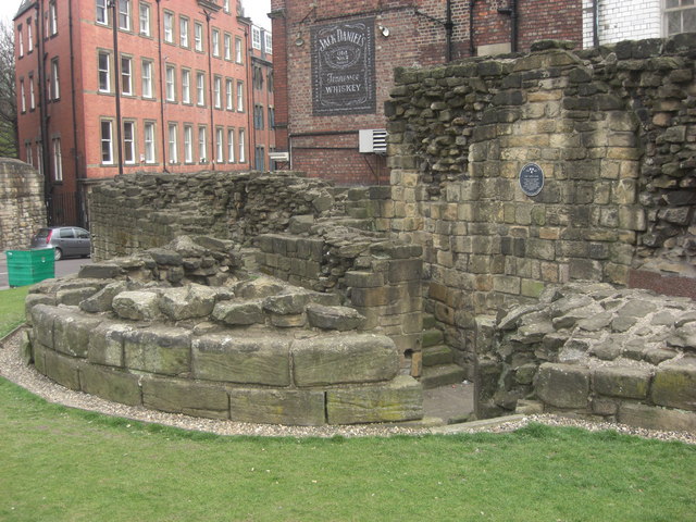
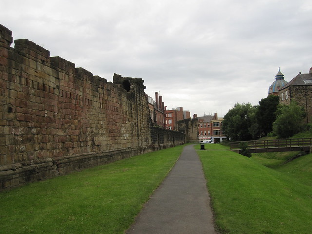
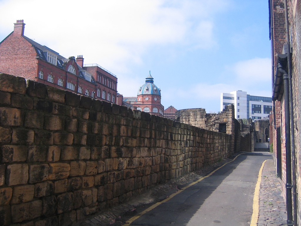
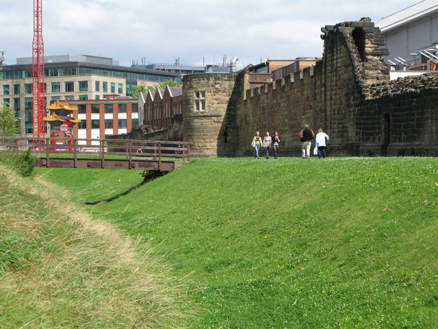
The best preserved section of Newcastle's Medieval Town Wall stretches from St Andrew's Street to Bath Lane, running parallel to Stowell Street. It includes Ever Tower (north end), Morden Tower, Heber Tower (south end) and two turrets. Parts of the curtain wall stand to their full height (1.68m high) and the defensive ditch ('the King's Dyke") runs alongside the wall. There were also two posterns (concealed entrances) in this section; one known as 'friar's postern' giving the monks of Blackfriars access to their land outside of the walls. Interestingly, the parapet walls were raised during the Napoleonic Wars, indicating the walls were still perceived to have defensive value in the early 19th century. This section of the Town Walls is Grade I listed on the National Heritage List for England and also a Scheduled Monument (legally protected).
Scheduled Monument (#1019280): Newcastle upon Tyne town defences: section of curtain wall containing Ever, Morden and Heber towers, two turrets and two sections of town ditch
Click the headings below to expand (selected extracts from the Historic England scheduling)
The standing remains of the medieval town wall between St Andrew's Street and Bath Lane survive well. They represent the longest and most complete length of the medieval circuit, complete with three towers, the remains of two turrets and in one place standing to its full height including the parapet. The extant section of the berm and outer ditch survive well and represent the only earthwork section of the ditch surviving in the City. As a monument which is accessible to the public, this section of Newcastle town defences serves as an important educational and recreational resource which will increase our understanding of how Newcastle's defences developed.
The monument is situated between St Andrew's Street and Bath Lane and runs parallel to Stowell Street. It includes the upstanding and buried remains of part of the town defences of Newcastle upon Tyne. The section of town defences between St Andrew's Street and Bath Lane represents part of the western side of the circuit and includes a 214m upstanding section of the curtain wall, three towers, the remains of two turrets and two posterns. Outside the wall there is a berm and ditch; the latter is partially visible as an earthwork since its limited excavation and subsequent display in the late 1980s. The town wall, towers and turrets are also Listed Grade I. Further sections of the town defences to the north east and south east and the Dominican Friary which lies to the east, are the subject of separate schedulings.
Newcastle upon Tyne town defences were constructed from the mid-13th century to the middle or late 14th century enclosing an area of more than 60ha; the riverside lengths of curtain wall were added during the 15th century. The masonry defences were strengthened by a berm and a ditch, except on the south side where they were bounded by the River Tyne. Gateways were built at the principal points of entry to the town. Internally a cobbled inter-mural lane followed the line of the defences. The wall was repaired several times during the medieval period and was reinforced and repaired several times during the post-medieval period.
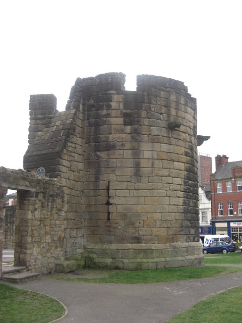
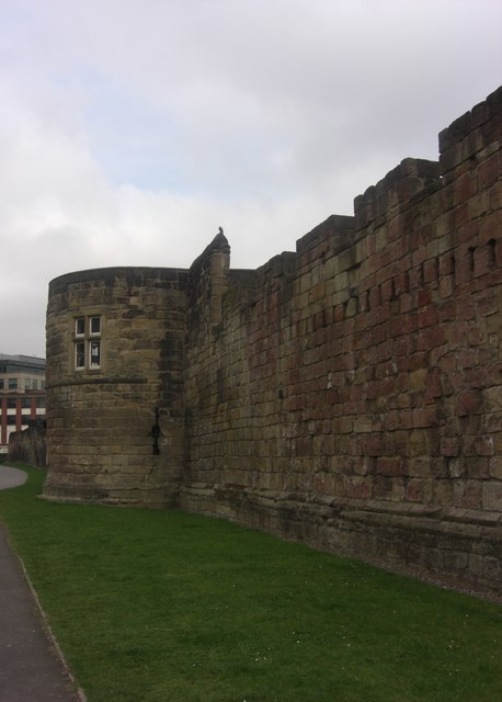
The curtain wall in this section is constructed of large square sandstone blocks bonded with mortar and is on average 2m wide; for much of its length it stands an average of 4.4m to the bottom of the parapet walkway. It contains the remains of three towers; the most northerly is known as Ever Tower, the most southerly is known as Heber Tower and the central tower is known as Morden Tower. The length of curtain wall between Ever and Heber towers stands to the full height of the parapet which is 1.68m high from the top of the wall walk. The parapet walls were raised in the early 19th century at the time of the Napoleonic Wars, and the blocked embrasures of the former parapet are visible between Ever and Morden towers.
The length of curtain wall between Morden and Heber towers was constructed through the precinct of the adjacent Dominican Friary and documentary sources indicate that it was completed between 1282-83. Partial excavation between Morden and Heber towers in 1987 revealed that the wall was constructed across an area of narrow ridge ploughing indicating that this area of the friar's precinct had been in cultivation prior to the wall's construction. Documents also refer to the construction of a small postern which was incorporated into this section of wall in order to allow access to the part of the friary precinct left outside of the wall. This postern, known as 'friar's postern' is visible on the external face of the curtain wall as an opening 1m wide and 2m high; this opening has been remodelled by the insertion of a flat lintel which replaced its original arched head. On the internal face of the wall the postern is visible as a wider arched opening 1.5m wide which was blocked during the 19th century. A second minor postern situated between Morden Tower and friar's postern is of unknown purpose and date.
Partial excavation against the west face of this length of wall in the late 1980's revealed that it was founded in a narrow trench and that the lowest course was composed of angular sandstone blocks bonded with soil. Above this the curtain wall was slightly inset and the double chamfer course, visible elsewhere around the circuit, was revealed. Immediately south of Heber Tower the ground level falls and the lower courses of the curtain wall in this area are stepped downwards.
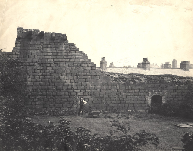
The first and most northerly tower, known as Ever Tower, is visible as the lower courses of a semicircular structure with a rectangular ground floor chamber; it retains the deep splays of three former cross window loops and projects forwards 4m from the outer face of the curtain wall. A drawing of the tower dated about 1789 shows that it had a parapet, several external projecting stone corbels interpreted as supports for timber hoardings or galleries and a small projecting latrine on the north side, at its junction with the curtain wall. During the 18th century the tower was granted to the Company of Paviours, Colliers and Carriers. The upper courses of the tower were dismantled in 1910 and a tannery built over the lower storey, which was itself removed in the 1930s.
Morden Tower lies 90m south west of Ever Tower; its tower, semicircular in shape, also has a rectangular ground floor chamber retaining its three cross loops and is covered by a stone vaulted roof. It projects some 4m from the outer face of the curtain wall. In 1619 an upper storey was added to this tower in order to accommodate the meetings of the Company of Glaziers, Plumbers and Pewterers. This addition was constructed in brick but faced in ashlar blocks. The tower was altered again in 1700 when the company built an inner face of brickwork. Partial excavation at the junction of the town wall with the south side of Morden Tower provided evidence that the tower was constructed before the curtain wall.
The third and most southerly tower, known as Heber Tower, is situated at the south end of the monument. It is visible as a semicircular, single storey building with an internal rectangular chamber which retains three cross shaped loops and the stone vault which carried its roof. It projects about 4m from the line of the curtain wall. Internally, a stone stair leads to the roof and the parapet walkway. Externally, the tower has several projecting stone corbels which served as supports for timber hoardings or galleries. There is a small projecting latrine on the south side of the tower and at its junction with the tower there is an additional cross loop. The tower was repaired in 1620 by the Company of Armourers, Curriers and Felt Makers.
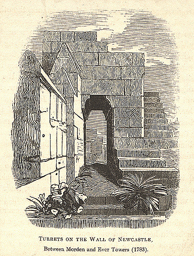
There are the remains of two turrets in this section of the town wall; the first between Ever and Morden towers is visible as a row of nine closely spaced corbels projecting from the inner face of the wall walk. The second turret between Morden and Heber towers is the best preserved of the two, and is visible as a rectangular structure containing a narrow chamber with a window loop facing west. It retains both doors through which passed the parapet walkway as well as the external staircase, supported on corbels projecting from the inner face, which gave access to the roof.
Outside of the curtain wall, there are the remains of the berm and the town ditch known as the King's Dike. The ditch survives partially as an earthwork and partially as an infilled and buried feature below the present level of the ground. In 1987 parts of the town ditch were excavated in the area between Morden and Heber towers and the location and extent of the ditch was identified. It was discovered to lie some 9.5m in front of the curtain wall and has maximum dimensions of 11.3m wide and is 4.5m deep. Although the lower deposits within the ditch had been recut on several occasions, most notably during the Civil War, an original narrow U-shaped gully at its bottom was visible. The digging of the ditch in this area in about 1312, served to cut off the friars from their friary precinct once more; partial excavation of the area between the friars postern and the inner lip of the ditch in the 1980's revealed the existence of a metalled surface interpreted as a roadway running from the postern towards the ditch. A lens of similar material was also uncovered on the outer lip of the ditch on the same alignment, and this was interpreted as the position of a bridge across the ditch mentioned in documentary sources. The excavations also showed that a series of lean-to structures had been built against the outer face of the curtain wall associated with a trackway which ran along the inner lip of the ditch. The slots to support these structures are visible on the external face of the curtain wall. These features were interpreted as being 17th century or earlier in date and of uncertain nature.
Co-Curate Page
Herber Tower
- Overview Map Street View Herber Tower (aka Heber Tower) was built as part of the Town Walls in Newcastle in the late 13th century. In 1827 Eneas Mackenzie wrote: "Herber Tower …
Co-Curate Page
Morden Tower
- Overview About the Tower & Poetry Centre Map Morden Tower is a turret on the west section of the Town Walls in Newcastle dating from 1280. Eneas Mackenzie, wrote in …
Co-Curate Page
Ever Tower
- Overview Map Street View Ever Tower was part of the defences of Medieval Newcastle, built in the 13th century. It is part of the best preserved sections of the Town …
from Newcastle libraries (flickr)
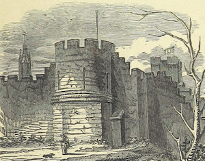
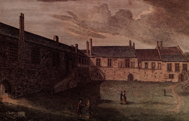
067321:Town Walls Stowell Street. Unknown. 1886.
Pinned by Simon Cotterill
from Newcastle libraries (flickr)
012313:Turret, Newcastle upon Tyne, 1783
Pinned by Simon Cotterill

Co-Curate Page
Herber Tower
- Overview Map Street View Herber Tower (aka Heber Tower) was built as part of the Town Walls in Newcastle in the late 13th century. In 1827 Eneas Mackenzie wrote: "Herber Tower …
Co-Curate Page
Morden Tower
- Overview About the Tower & Poetry Centre Map Morden Tower is a turret on the west section of the Town Walls in Newcastle dating from 1280. Eneas Mackenzie, wrote in …
Co-Curate Page
Ever Tower
- Overview Map Street View Ever Tower was part of the defences of Medieval Newcastle, built in the 13th century. It is part of the best preserved sections of the Town …
from Newcastle libraries (flickr)
067321:Town Walls Stowell Street. Unknown. 1886.
Pinned by Simon Cotterill
from Newcastle libraries (flickr)
012313:Turret, Newcastle upon Tyne, 1783
Pinned by Simon Cotterill