Topics > Heritage Sites > Newcastle Town Walls > Town Wall section near Hanover Street
Town Wall section near Hanover Street
Scheduled Monument area - based on Historic England data (Open Government Licence).
This Scheduled Monument is a section of the Town Wall which stretch between Hanover Street and the River Tyne, in Newcastle. It includes a 26m upstanding length of the curtain wall and a 45m and a 6.25m wide buried length of curtain wall, and the buried remains of Close Gate and the Water Tower (aka Riverside Tower).
Scheduled Monument (#1019814): Newcastle upon Tyne town defences: section of curtain wall including Closegate and Water Tower
Click the headings below to expand (selected extracts from the Historic England scheduling)
Despite some parts of this section surviving below the level of the ground as buried features, the remains of the medieval curtain wall between Hanover Street and the River Tyne survive reasonably well. The preservation of the remains of the tower and curtain wall will provide a valuable insight into the construction techniques employed during the medieval period. The section of 15th century riverside curtain wall and its relationship to the tower is of particular importance as it will contribute to our knowledge of how the defensive circuit evolved during the medieval period. The tower is of unusual form and is a valuable addition to our knowledge. As a monument which is partially accessible to the public, this section of Newcastle's town defences serves as an important educational and recreational resource which will increase our understanding of how Newcastle's defences developed.
The monument is situated between Hanover Street and the north bank of the River Tyne. It includes the upstanding and buried remains of part of the town defences of Newcastle upon Tyne. The section of town defences between Hanover Street and the River Tyne represents the junction between the western side of the circuit and the later riverside length of curtain wall. It includes a 26m upstanding length and a 45m and a 6.25m wide buried length of curtain wall, a gateway and a tower. The upstanding length of curtain wall is also a Listed Building Grade I. Further sections of the town defences to the north and east are the subject of separate schedulings.
Newcastle upon Tyne town defences were constructed from the mid-13th century to the middle or late 14th century enclosing an area of more than 60ha; the riverside lengths of curtain wall were added during the 15th century. The masonry defences were strengthened by a berm and a ditch, except on the south side where they were bounded by the River Tyne. Gateways were built at the principal points of entry to the town. Internally a cobbled inter-mural lane followed the line of the defences. The defences were repaired during the medieval period and were reinforced and repaired several times during the post-medieval period.
In this section, immediately north of The Close, on the sloping ground south of Hanover Street, there is an upstanding length of curtain wall 26m long which stands to a maximum height of 4.25m, known as Breakneck Stairs. The wall is constructed of coursed squared ashlar sandstone with a rubble core and is up to 3m wide. It has been built in a series of steps in order to account for the steep gradient.
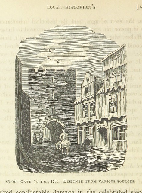
At the southern end of this length of wall, on the flat land at the bottom of the slope beneath The Close, there are the levelled and buried remains of Closegate, one of the principal points of entry to the town. The upper courses of the gateway were dismantled in 1797 but a retrospective 19th century engraving depicts it as a three storey rectangular building containing a central archway.
Between Closegate and the River Tyne, there is a 45m length of curtain wall which survives below ground level as a buried feature. This length of curtain wall was uncovered by excavation in 1988 and was shown to have been constructed in the mid-14th century. The footings of the wall which are large, irregularly shaped blocks, are founded in a shallow trench 0.10m to 0.15m deep, cut into the river bank, and, where they extended into the river, lain directly onto the natural sand of the river bed. The wall varies between 2.05m and 2.8m wide and a stepped chamfered plinth survives on its outer western face. Excavation also revealed that this length of wall had been constructed in a series of steps in order to take account of the sloping river bed.
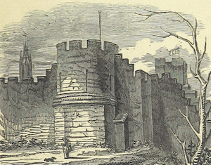
The southern end of the curtain wall was subsequently remodelled in order to incorporate a staircase which gave access to a tower, known as Water Tower, which was added to the town defences in the early 15th century. It is situated in the angle formed by the junction of the western side of the defences and the later riverside section of curtain wall forming the south side of the circuit. An engraving of the tower made in 1745 shows it as a square, crenellated structure, and it is recorded as still partially standing in 1789. An engraving of the tower in 1846 depicts it as having three storeys with its upper parts rebuilt in brick. From the late 17th century and through the 18th century the tower was the meeting house for the Company of Housecarpenters and subsequently the Company of Sailmakers. The plan of Water Tower was uncovered by excavation in 1988. The tower, square in shape, measures 6.5m north to south by 6m east to west and has walls ranging from 1.02m to 1.10m wide. The foundations of the south and west walls are between 2.1m to 2.3m wide while those of the north and east are 1.20m wide. There is an entrance way into the tower through the east end of the north wall which retains both the sill and one of the door jambs. In the north west angle of the tower's ground floor there was a fireplace indicated by areas of reddening on the adjacent stonework. The excavation also revealed that the ground floor of the tower was occupied in the years following the English Civil War until the mid-18th century as occupation deposits and the remains of light timber screens or room partitions were discovered.
Attached to the eastern side of Water Tower there is a short length of riverside curtain wall, which was uncovered by excavation and survives below ground level as a buried feature. This wall runs parallel to the River Tyne and was constructed in the early 15th century. The curtain wall is on average 1.74m wide, 6.25m long and stands to a maximum height of 4.4m; its south, external face contains two chamfers at its base.

from https://www.geograph.org.uk/p…
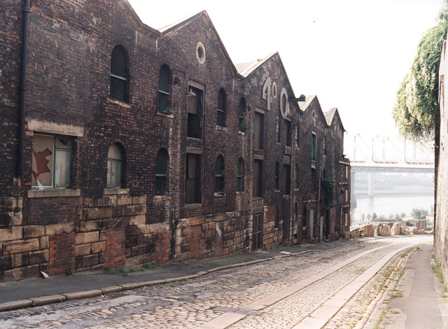
Fragment of the Newcastle Town Wall
- 14th century fragment of the Town Wall near Hanover Street. Photo by Oliver Dixon, 16 August, 2017 , Geograph, CC-BY-SA 2.0
Added by
Simon Cotterill

from https://www.geograph.org.uk/p…
Plaque on the 14th C town walls
- Photo by Mike Quinn, 6 August, 2008, Geograph, CC-BY-SA 2.0
Added by
Simon Cotterill

from https://historicengland.org.u…
Newcastle upon Tyne town defences: section of curtain wall including Closegate and Water Tower - Scheduling
- ....Despite some parts of this section surviving below the level of the ground as buried features, the remains of the medieval curtain wall between Hanover Street and the River Tyne …
Added by
Simon Cotterill

Co-Curate Page
Riverside Tower
- Overview Map The Riverside Tower (aka Water Tower) was an early 15th century addition to the Newcastle Town Walls. It stood where the Copthorne Hotel is now located, near the …
Co-Curate Page
Close Gate
- Overview Map Close Gate (aka Closegate) on the Town Walls was one of the principal points of entry to Newcastle during Medieval times. In the 18th century the tower served …

from https://www.geograph.org.uk/p…
Fragment of the Newcastle Town Wall
- 14th century fragment of the Town Wall near Hanover Street. Photo by Oliver Dixon, 16 August, 2017 , Geograph, CC-BY-SA 2.0
Added by
Simon Cotterill
from https://www.geograph.org.uk/p…
Plaque on the 14th C town walls
- Photo by Mike Quinn, 6 August, 2008, Geograph, CC-BY-SA 2.0
Added by
Simon Cotterill
from https://historicengland.org.u…
Newcastle upon Tyne town defences: section of curtain wall including Closegate and Water Tower - Scheduling
- ....Despite some parts of this section surviving below the level of the ground as buried features, the remains of the medieval curtain wall between Hanover Street and the River Tyne …
Added by
Simon Cotterill
Co-Curate Page
Riverside Tower
- Overview Map The Riverside Tower (aka Water Tower) was an early 15th century addition to the Newcastle Town Walls. It stood where the Copthorne Hotel is now located, near the …