Topics > Northumberland > Civil Parishes in Northumberland > Blyth Town Council Area > Historic Buildings and Monuments in Blyth
Historic Buildings and Monuments in Blyth
Listed Buildings, Scheduled Monuments and Conservation Areas in Blyth, Northumberland, from the National Heritage List for England. Also including buildings on the 'local list' of non-designated heritage assets. Use the Search (below) to find/filter the list. Jump to Photos and further details.
| Structure | List No. | Grade | Built~ | Note |
|---|---|---|---|---|
| No. 11, Bath Terrace | 1041338 | II | C18th | |
| No. 12, Bath Terrace | 1371410 | II | c.1800 | |
| No. 13, Bath Terrace | 1041339 | II | C19th | |
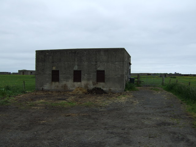
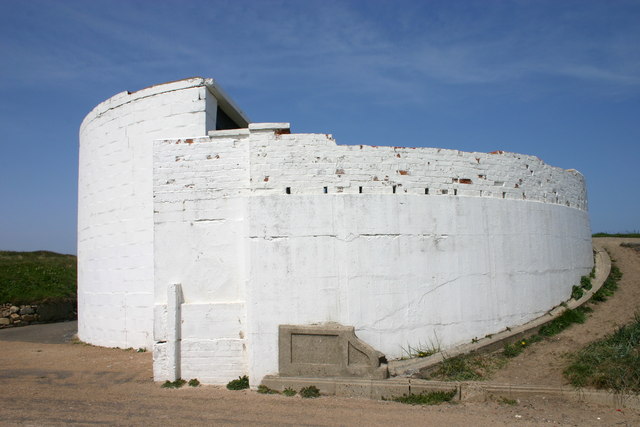
| 2 Defence Electric Light Emplacements to East of Link House | 1371407 | II | c.1914 | |
| Nos. 4 and 6, Wensleydale Terrace | 1154715 | II | 1821 | |
| Nos. 5-10, Bath Terrace | 1371409 | II | 1790 | |
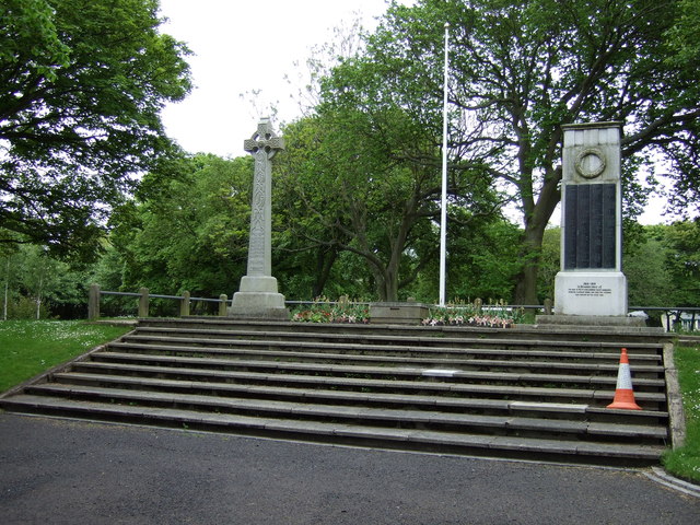
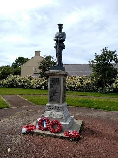
| Blyth First World War Memorial | 1433647 | II | 1923 | In Ridley Park |
| Blyth Submariners' War Memorial | 1433644 | II | c.1916 | In Blyth South Beach Cemetery |
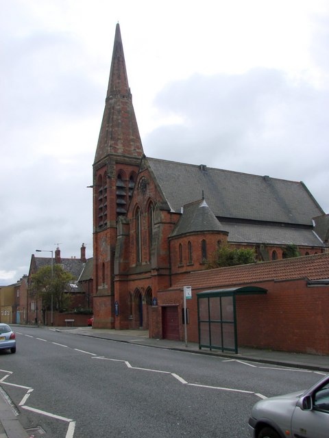
| Blyth United Reformed Church | 1041348 | II | 1876 | Waterloo Road. Now Headway Arts |
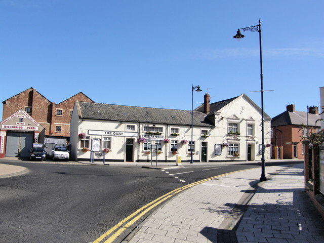
| Boathouse Tavern | 1371412 | II | C17th | Bridge Street. Now 'The Quay' |
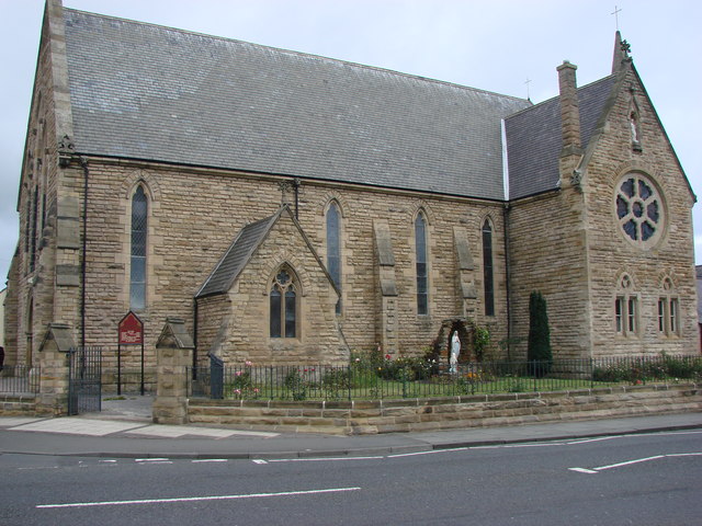
| Church of Our Lady and St Wilfred | 1154702 | II | 1862 | Waterloo Road |
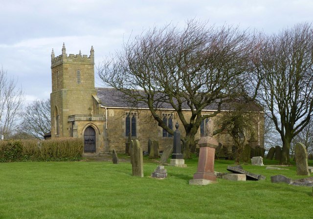
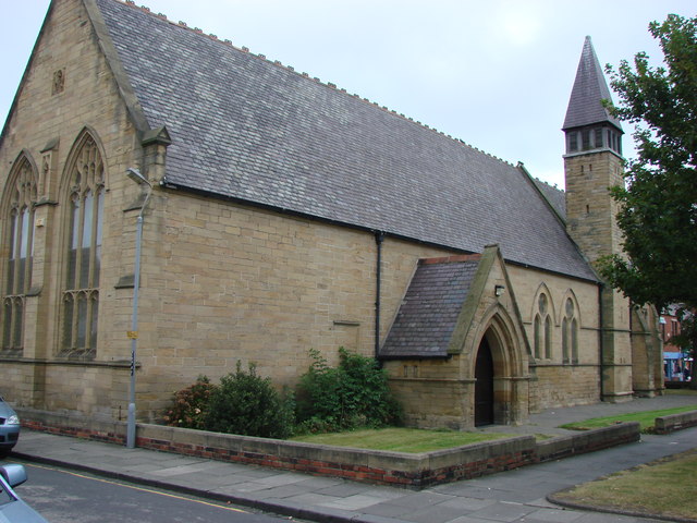
| Church of St Mary | 1154689 | II | 1864 | Wanley Street, Blyth |
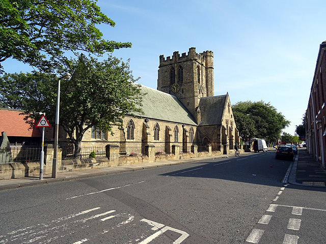
| Church of St Cuthbert | 1041345 | II* | 1892 | Replaced earlier church of 1751. |
| Gloucester Lodge Heavy Anti-Aircraft Battery | 1402264 | n/a | 1941 | Scheduled Monument. |
| Coastal Artillery Battery on Blyth Links | 1021401 | n/a | 1916 | Scheduled Monument. |
| Former Rocket House | 1396399 | II | C19th | Bath Terrace |
| Fort on Blyth Links | 1041334 | II | C19th | aka Fort Ccoulson. Remodelled 1914-18. |
| Front Garden Walls to Numbers 4 and 6 | 1041349 | II | c.1821 | Wensleydale Terrace |
| Fynes Memorial in Cowpen Cemetery, 75 Metres South East of Cemetery Chapels | 1154669 | II | 1892 | Memorial to Richard Fynes |
| Gate Pier at Entrance to Link House Farm | 1041335 | II | C17th | |
| Gates and Screen Wall at Entrance to Cowpen Cemetery | 1154663 | II | c.1875 | |
| Grotto, 100 Metres South of Bebside North Farm | 1303739 | II | C18th | Associated with Bebside Old Hall |
| Church of St Mary | 1303743 | II | 1827 | Horton. On medieval site. |
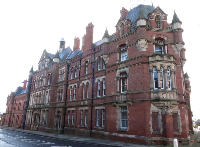
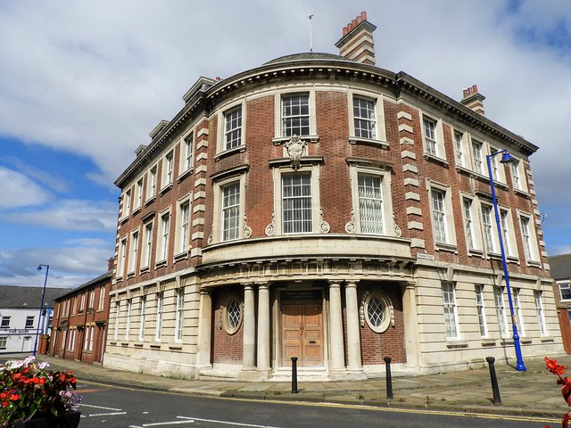
| Harbour Commissioners Offices | 1041341 | II | 1913 | Bridge Street |
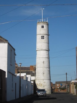
| High Light (Lighthouse Attached to Rear Wing of Number 8) | 1371411 | II | 1788 | Back lane of Bath Terrace |
| House 10 Metres North of St Mary's Church | 1041347 | II | 1858 | Wanley Street, former headmaster's house |
| Kings Head Hotel | 1041340 | II | C19th | Bridge Street. Now cafe. |
| Lloyds Bank | 1303735 | II | 1898 | Bridge Street. Now The Marahaj's Lounge. |
| Low Horton Farmhouse | 1041377 | II | C18th | Horton. |
| Pair of Chapels in Cowpen Cemetery | 1041343 | II | c.1875 | |
| Police Station | 1371413 | II | 1896 | Bridge Street. Former police station. |
| Public Lavatory, Outbuilding and Enclosing Walls, to East of Link House | 1276282 | II | c.1914 | Former engine house for searchlights. |
| Roman Catholic Church of St Cuthbert | 1431014 | II | 1840 | Cowpen Road |
| Straugham Tomb, 6 Metres West of St Cuthbert's Church Hall | 1154682 | II | 1817 | Tomb: William & Mary Straugham |
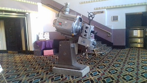
| The Wallaw Cinema | 1031569 | II | 1937 | Former cinema, now a Wetherspoon pub. |
| War Memorial in Miners Welfare Park | 1303710 | II | c.1919 | |
| War Memorial to West of Junction with Briardale Road | 1041344 | II | 1920 | Cowpen |
| Watts and English Headstone 8 Metres South of St Cuthbert's Church Hall | 1041346 | II | C18th | |
| Barclays Bank, Bridge Street | local lisl | n/a | C19th | Bridge Street |
| Beach Bandstand | local list | n/a | c.1929 | Beach Gardens, South Beach |
| Bebside Viaduct | local list | n/a | ||
| Beulah House, No 123 Bondicarr Terrace | local list | n/a | C19th | |
| Blyth Civic Centre | local list | n/a | 1926 | |
| Blyth and Tyne, Regent Street | local list | n/a | C19th | Public House |
| Blyth harbour defence post | local list | n/a | C20th | WW2 defence |
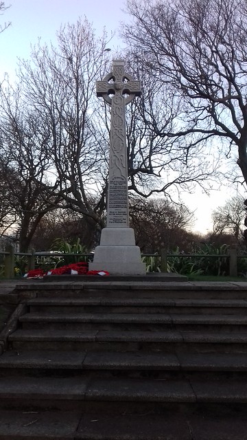
| Boer War Memorial | local list | n/a | 1903 | Ridley Park |
| Buffalo Community Centre | local list | n/a | C19th | Regent Street |
| Building north of Harbour Offices | local list | n/a | C20th? | Quay Road |
| Chapel of Ease and associated buildings | local list | n/a | 1880s | Links Road |
| Coquetdale House | local list | n/a | C19th | Marine Terrace |
| Crown Carpets | local list | n/a | 1924 | Croft Road |
| Customs House | local list | n/a | C19th | Ridley Street |
| Dinsdale House | local list | n/a | 1899 | Marine Terrace |
| Fairholme | local list | n/a | C19th | Marine Terrace |
| HBSC, Nos 29 to 31 Bridge Street | local list | n/a | c.1901 | Bridge Street |
| Herron's Jewellers | local list | n/a | c.1870 | Regent Street |
| Keelman's House | local list | n/a | 1913 | Summers Street |
| Library | local list | n/a | 1882 | Bridge Street |
| Lifeboat Station | local list | n/a | 1920 | Quay Road |
| Marlow Lodge (formerly Thoroton Hotel) | local list | n/a | C19th | Marlow Street |
| Newsham Station Masters House | local list | n/a | 1853 | Newsham |
| No 10, Park View | local list | n/a | c.1890s | |
| No 12, Bridge Street | local list | n/a | C19th | Bridge Street |
| No 24, Bridge Street | local list | n/a | C19th | Bridge Street |
| No 41, Waterloo Road | local list | n/a | C19th | |
| No 4, Bridge Street | local list | n/a | 1937 | Bridge Street |
| No 43, Waterloo Road | local list | n/a | C19th | |
| No 62, Regent Street | local list | n/a | 1898 | Regent Street |
| No 76, Middleton Street | local list | n/a | C19th | |
| No 72, Middleton Street | local list | n/a | C19th | |
| No 78, Middleton Street | local list | n/a | 1899 | |
| No 79 Waterloo Road | local list | n/a | C19th | |
| Nos 1-4, Bath Terrace | local list | n/a | C19th | |
| Nos 1-7, Bridge Street | local list | n/a | C19th | Bridge Street |
| Nos 1-8, Quayside House | local list | n/a | C20th | Sussex Street. |
| Nos 14-17, Bath Terrace | local list | n/a | 1920s | |
| Nos 2-12, Union Street | local list | n/a | C19th | |
| Nos 2-6, Sussex Street | local list | n/a | C19th | |
| Nos 21-25, Waterloo Road | local list | n/a | C19th | |
| Nos 23-27, Bridge Street | local list | n/a | 1901 | Bridge Street |
| Nos 27-29, Waterloo Road | local list | n/a | C19th | |
| Nos 31-35 Waterloo Road | local list | n/a | 1890s | |
| Nos 35-39, Bridge Street | local list | n/a | 1901 | Bridge Street |
| Nos 37-39, Waterloo Street | local list | n/a | C19th | |
| Nos 62-64, Bridge Street | local list | n/a | C19th | Bridge Street |
| Oddfellows Arms | local list | n/a | C19th | Bridge Street |
| Blyth Heritage Conservation Area | CA | n/a | - | |
| Blyth Central Conservation Area | CA | n/a | - | |
| Blyth Bondicar Terrace Conservation Area | CA | n/a | ||
| Post Office, No 21, Bridge Street | local list | n/a | C20th | Bridge Street |
| Presbytery to the Church of Our Lady and Saint Wilfrid | local list | n/a | C19th | Waterloo Road |
| Prince of Wales, Waterloo Road | local list | n/a | 1899 | Public House |
| Former Saint Wilfrid's Infant School | local list | n/a | C19th | Arthur Street |
| St Cuthbert's Church Hall | local list | n/a | 1925 | Bridge Street |
| Station Master's House | local list | n/a | 1884 | Delaval Terrace |
| Steamboat Inn, Bridge Street | local list | n/a | 1880s | Bridge Street |
| The Bebside Inn | local list | n/a | C19th? | |
| The Pullman, Regent Street | local list | n/a | C19th | Public House |
| The Top House, Marlow Street | local list | n/a | C19th | Public House |
| The Waterloo, 17 Bondicar Terrace | local list | n/a | c.1900 | Public House |
| The Windmill, Cowpen Road | local list | n/a | C19th | Public House |
| Warehouse on Ridley Street/Tate Street | local list | n/a | C19th | |
| Warrant Officer's Quarters (Fort House), Link House Battery | local list | n/a | ? | |
| YMCA, Bondicarr Terrace/Wolsley Terrace | local list | n/a | C19th | |
| 18 Bridge Street (Poundstretcher) | local list | n/a | 1890s | Bridge Street |
Sources: the National Heritage List for England - NHLE is the register of nationally protected historic buildings and sites in England, including listed buildings, scheduled monuments, protected wrecks, registered parks and gardens, and battlefields. The list is maintained by Historic England. Check NHLE for updates and new entries. Secondary sources: British Listed Buildings and Keys to the Past. Local List based on Blyth Neighbourhood Plan, Non-designated Heritage Assets Background Paper, October 2024 (Blyth Town Council).
Co-Curate Page
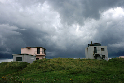
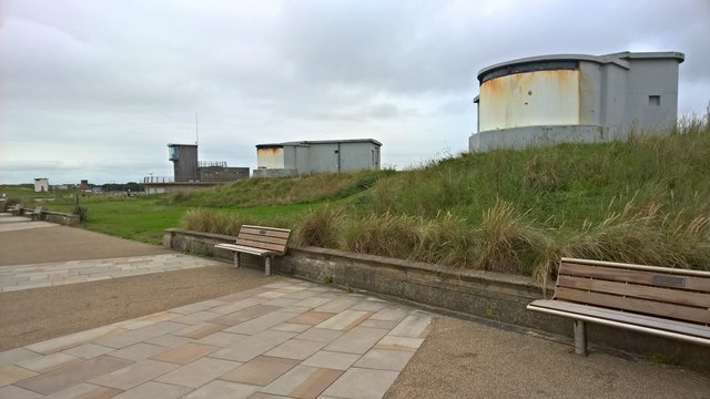
Blyth Battery
- Overview Map Street View Blyth Battery is a Military and Local Heritage museum which is free to visit. The artillery battery was originally built in 1916 to defend the port …
Co-Curate Page
First World War Memorial
- Overview Map Street View The First World War memorial for Blyth (including New Delaval, Newsham, Bebside and Cowpen) was originally located outside the Knight Memorial Hospital on Beaconsfield Street. It …
Co-Curate Page
High Light, Lighthouse
- Overview Map Street View The High Light in Blyth was built c.1788 and worked in conjunction with the Low light (rebuilt 1936). It was heightened twice and the light was in …
Co-Curate Page
Church of St. Cuthbert
- Overview Map Street View The Church of St. Cuthbert in Blyth, Northumberland was built in 1892. It replaced an earlier church built in 1751; at that time Blyth was part …
Co-Curate Page
Wallaw
- Overview Map The Wallaw Cinema on Union Street in Blyth opened on 16th November 1937 with 1,600 seats. It was designed by Percy Lindsay Browne, Son & Harding, for the …
Co-Curate Page
Gloucester Lodge Heavy Anti-Aircraft Battery
- Gloucester Lodge Battery, just south of Blyth, was a Second World War heavy anti-aircraft gun battery and radar site. It is one of only a handful of complete or near …
Co-Curate Page
Church of Our Lady and St. Wilfrid
- Overview Map Street View Our Lady and St Wilfred's Roman Catholic church is located on Waterloo Road, Blyth Northumberland. The church was built 1862 and is Grade II listed on …
Co-Curate Page
Church of St. Mary, Horton, Blyth
- Overview Map Street View The Church of St. Mary the Virgin is the parish church located on Horton Road in Horton, Blyth. The church is on the site of a medieval …
Co-Curate Page
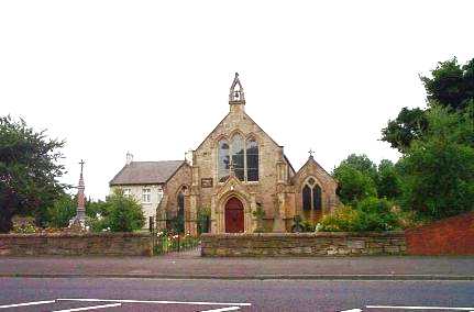
Headway ArtsSpace, former URC Church
- Overview Map Street View Headway ArtSpace is located in The Old Church on Waterloo Road in Blyth. The brick-built Gothic revival-style church was built 1874-1876, by Thomas Oliver junior. It was …
Co-Curate Page
The Quay (Pub)
- Overview Map Street View The Quay is a public house on Bridge Street, by the junction with Quay Road in Blyth. It was formerly known as the Boathouse Tavern and …
Co-Curate Page
Church of St Mary, Blyth
- Overview Map Street View St Mary's Church is located on Wanley Street in Blyth. It was originally built in 1864 by Austin and Johnson as chapel of ease to St. …
Co-Curate Page
Old Police Station, Blyth
- Overview Map Street View The former Police Station is located on the south side of Bridge Street in Blyth. The Police Station was built in 1896 by John Cresswell, the County …
Co-Curate Page
Church of St Cuthbert RC, Cowpen
- Overview Map Street View The Roman Catholic church of St Cuthbert in Cowpen, Blyth, Nothumberland, is located off Cowpen Road (A193). The Sidney Family came to Cowpen Hall in 1804 …
Co-Curate Page
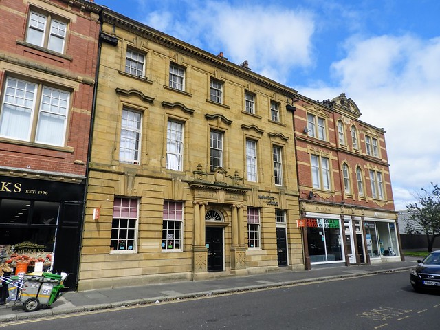
Former Lloyds Bank
- Overview Map Street View The Maharaj's Lounge is located at No. 33 Bridge Street in Blyth. The building was originally built in 1898 as a Lloyds Bank. The building is …
Co-Curate Page
WW1 Searchlight Emplacements
- Overview Map Street View Two defence electric light emplacements from the First World War located on the Links at Blyth. The emplacements were operated by an E.L.O. (Electric Light Officer) …
Co-Curate Page
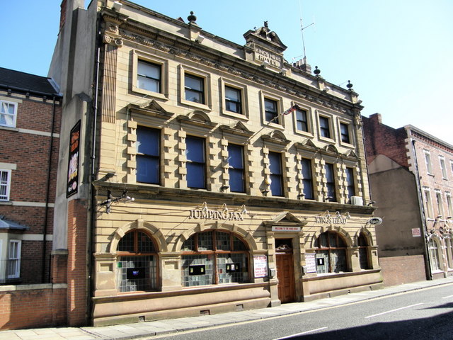
The King's Head, Blyth
- Overview Map Street View The Kings Head Cafe is located on Bridge Street in Blyth. Formerly, it was the Kings Head Hotel. The hotel was built in the late 19th century …
Co-Curate Page
Cowpen War Memorial
- The war memorial in Cowpen, Blyth, is located on the junction of Briardale Road and Cowpen Road. It was built in 1920 to commemorate 59 local servicemen who lost their …
Co-Curate Page
Fort Coulson
- Fort Coulson was a coastal defence fort located on the Links at Blyth. It was originally built in the late 19th century, then remodelled as a gun emplacement during the First …
Co-Curate Page
Former Harbour Commissioner's Offices
- Overview Map Street View The former Harbour Commissioner's Offices are located on the corner of Bridge Street and Plessey Road in Blyth. They were built in 1913 by Cackett and …
Co-Curate Page
Boer War Memorial, Ridley Park
- Overview Map Street View The celtic cross in Ridley Park, Blyth, is a memorial to the 6 local service men who lost their lives in the Second Boer War (1899-1902). …
Co-Curate Page
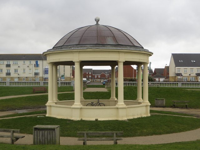
Blyth Bandstand
- Overview Map Street View Blyth Bandstand dates from c.1929.[1] It is situated by the South Beach promenade, in Beach Gardens, which were laid out by 1950. The bandstand is considered …
Co-Curate Page
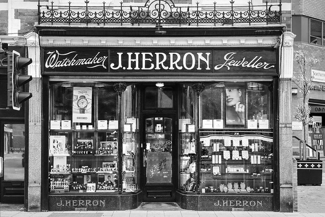
Herron's Jewellers, Blyth
- Overview Map Street View J Herron & Son is a jewellery shop, located at No. 66 Regent Street in Blyth. The building retains it's original shopfront of c.1870.[1] The family …
Co-Curate Page
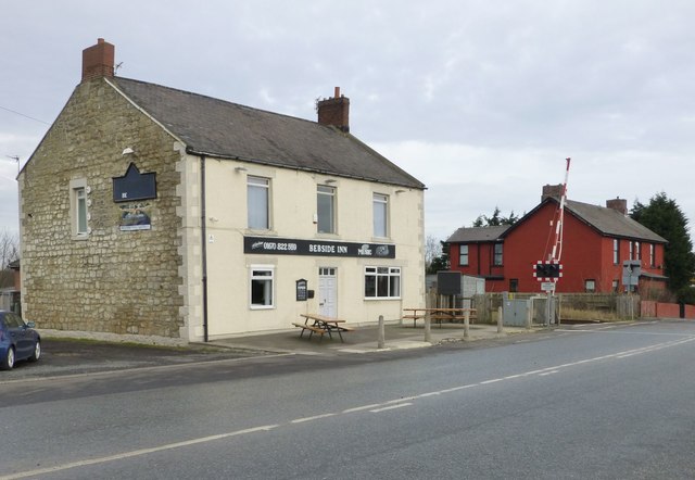
Bebside Inn
- Overview Map Street View The Bebside Inn (affectionately known as "The Bebby") is a public house located on Front Street in Bebside, Blyth. The inn was redeveloped and reopened in …
Co-Curate Page
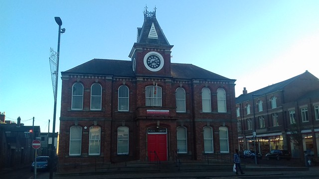
Library
- Overview Map Street View The Library is located at No. 20, Bridge Street, in Blyth. The building, with its distinctive clock tower, was originally a Mechanics Institute built in a …

Co-Curate Page
Blyth Battery
- Overview Map Street View Blyth Battery is a Military and Local Heritage museum which is free to visit. The artillery battery was originally built in 1916 to defend the port …
Co-Curate Page
First World War Memorial
- Overview Map Street View The First World War memorial for Blyth (including New Delaval, Newsham, Bebside and Cowpen) was originally located outside the Knight Memorial Hospital on Beaconsfield Street. It …
Co-Curate Page
High Light, Lighthouse
- Overview Map Street View The High Light in Blyth was built c.1788 and worked in conjunction with the Low light (rebuilt 1936). It was heightened twice and the light was in …
Co-Curate Page
Church of St. Cuthbert
- Overview Map Street View The Church of St. Cuthbert in Blyth, Northumberland was built in 1892. It replaced an earlier church built in 1751; at that time Blyth was part …
Co-Curate Page
Wallaw
- Overview Map The Wallaw Cinema on Union Street in Blyth opened on 16th November 1937 with 1,600 seats. It was designed by Percy Lindsay Browne, Son & Harding, for the …
Co-Curate Page
Gloucester Lodge Heavy Anti-Aircraft Battery
- Gloucester Lodge Battery, just south of Blyth, was a Second World War heavy anti-aircraft gun battery and radar site. It is one of only a handful of complete or near …
Co-Curate Page
Church of Our Lady and St. Wilfrid
- Overview Map Street View Our Lady and St Wilfred's Roman Catholic church is located on Waterloo Road, Blyth Northumberland. The church was built 1862 and is Grade II listed on …
Co-Curate Page
Church of St. Mary, Horton, Blyth
- Overview Map Street View The Church of St. Mary the Virgin is the parish church located on Horton Road in Horton, Blyth. The church is on the site of a medieval …
Co-Curate Page
Headway ArtsSpace, former URC Church
- Overview Map Street View Headway ArtSpace is located in The Old Church on Waterloo Road in Blyth. The brick-built Gothic revival-style church was built 1874-1876, by Thomas Oliver junior. It was …
Co-Curate Page
The Quay (Pub)
- Overview Map Street View The Quay is a public house on Bridge Street, by the junction with Quay Road in Blyth. It was formerly known as the Boathouse Tavern and …
Co-Curate Page
Church of St Mary, Blyth
- Overview Map Street View St Mary's Church is located on Wanley Street in Blyth. It was originally built in 1864 by Austin and Johnson as chapel of ease to St. …
Co-Curate Page
Old Police Station, Blyth
- Overview Map Street View The former Police Station is located on the south side of Bridge Street in Blyth. The Police Station was built in 1896 by John Cresswell, the County …
Co-Curate Page
Church of St Cuthbert RC, Cowpen
- Overview Map Street View The Roman Catholic church of St Cuthbert in Cowpen, Blyth, Nothumberland, is located off Cowpen Road (A193). The Sidney Family came to Cowpen Hall in 1804 …
Co-Curate Page
Former Lloyds Bank
- Overview Map Street View The Maharaj's Lounge is located at No. 33 Bridge Street in Blyth. The building was originally built in 1898 as a Lloyds Bank. The building is …
Co-Curate Page
WW1 Searchlight Emplacements
- Overview Map Street View Two defence electric light emplacements from the First World War located on the Links at Blyth. The emplacements were operated by an E.L.O. (Electric Light Officer) …
Co-Curate Page
The King's Head, Blyth
- Overview Map Street View The Kings Head Cafe is located on Bridge Street in Blyth. Formerly, it was the Kings Head Hotel. The hotel was built in the late 19th century …
Co-Curate Page
Cowpen War Memorial
- The war memorial in Cowpen, Blyth, is located on the junction of Briardale Road and Cowpen Road. It was built in 1920 to commemorate 59 local servicemen who lost their …
Co-Curate Page
Fort Coulson
- Fort Coulson was a coastal defence fort located on the Links at Blyth. It was originally built in the late 19th century, then remodelled as a gun emplacement during the First …
Co-Curate Page
Former Harbour Commissioner's Offices
- Overview Map Street View The former Harbour Commissioner's Offices are located on the corner of Bridge Street and Plessey Road in Blyth. They were built in 1913 by Cackett and …
Co-Curate Page
Boer War Memorial, Ridley Park
- Overview Map Street View The celtic cross in Ridley Park, Blyth, is a memorial to the 6 local service men who lost their lives in the Second Boer War (1899-1902). …
Co-Curate Page
Blyth Bandstand
- Overview Map Street View Blyth Bandstand dates from c.1929.[1] It is situated by the South Beach promenade, in Beach Gardens, which were laid out by 1950. The bandstand is considered …
Co-Curate Page
Herron's Jewellers, Blyth
- Overview Map Street View J Herron & Son is a jewellery shop, located at No. 66 Regent Street in Blyth. The building retains it's original shopfront of c.1870.[1] The family …
Co-Curate Page
Bebside Inn
- Overview Map Street View The Bebside Inn (affectionately known as "The Bebby") is a public house located on Front Street in Bebside, Blyth. The inn was redeveloped and reopened in …


