Topics > Civil Parishes in Cumbria > Former Borough of Barrow-In-Furness Area > Historic Buildings and Monuments in Barrow-in-Furness
Historic Buildings and Monuments in Barrow-in-Furness
Listed buildings and scheduled monuments in Barrow-in-Furness, from the National Heritage List for England[1]. In the absence of a published 'local list', some other public buildings of interest may also be included. Use the Search (below) if looking for a specific building / monument. See separate lists for the civil parishes of Askam & Ireleth, Dalton Town with Newton, and Lindal & Marton. Jump to Photos.
| Structure | List No. | Grade | Built~ | Ward~ | Note |
|---|---|---|---|---|---|
| No. 1, St Georges Square | 1282846 | II | Central | ||
| Nos. 1-41, Parade Street | 1218627 | II | Central | ||
| Nos. 111-119, Duke Street | 1292434 | II | Central | ||
| Nos. 113-119, Rawlinson Street | 1201074 | II | Central | ||
| No. 125, Duke Street | 1283001 | II | Central | ||
| Nos. 127, 129 and 131, Duke Street | 1197854 | II | Central | ||
| Nos. 14-20, Salthouse Road | 1218767 | II | Central | ||
| Nos. 2-10, Salthouse Road | 1201078 | II | Central | ||
| Nos. 2-46, Keith Street | 1283027 | II | Central | ||
| Nos. 2-46, Parade Street | 1283058 | II | Central | ||
| Nos. 3-51 Keith Street | 1218244 | II | Central | ||
| No. 36, Dalton Road | 1197889 | II | Central | ||
| No. 4, Duke Street | 1209874 | II | c.1900 | Central | |
| Nos. 6-26, School Street | 1282849 | II | Central | ||
| Nos. 63, 65 and 67, Duke Street | 1197892 | II | Central | ||
| Nos. 77 and 79, Duke Street | 1292429 | II | Central | ||
| Nos. 81-89, Duke Street | 1283000 | II | Central | ||
| Alfred Barrow School, Centre Block | 1283022 | II | Central | ||
| Bank Chambers | 1197893 | II | Central | ||
| Central Fire Station | 1197911 | II | 1911 | Central | Abbey Road. Now shops. |
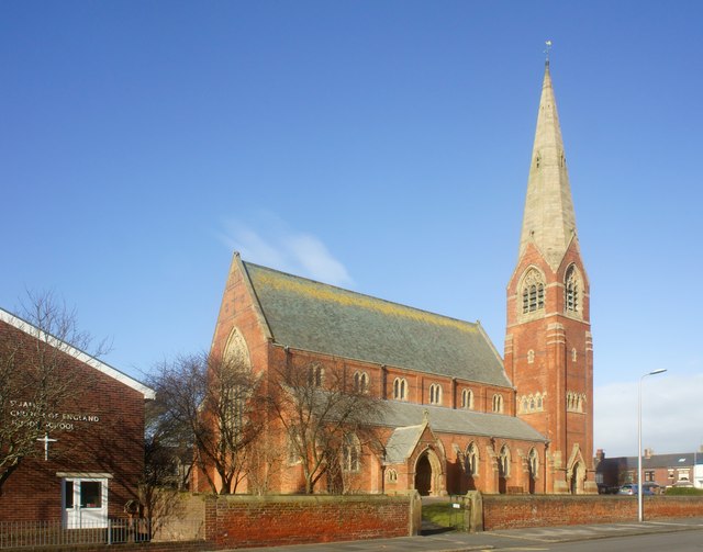
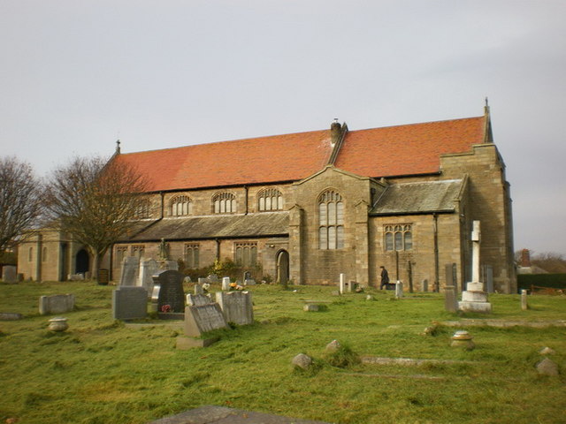
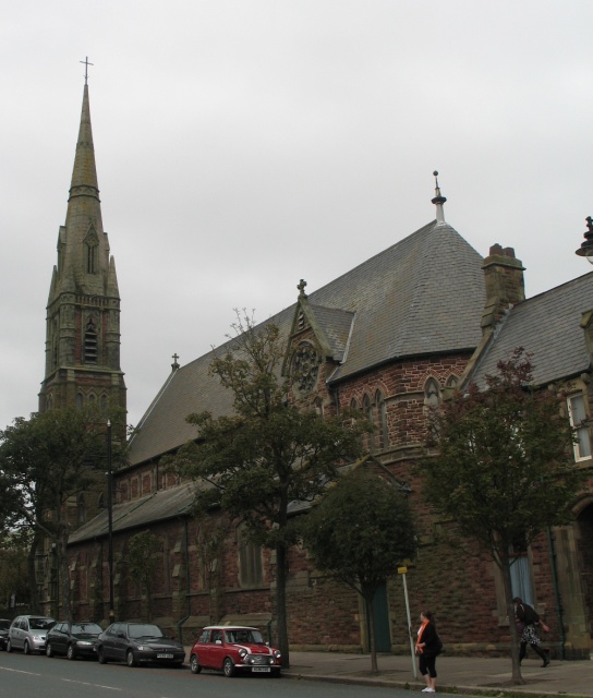
| Church of St George | 1201077 | II | 1861 | Central | |
| Harbour Hotel | 1291731 | II | Central | ||
| Hotel Imperial | 1197887 | II | Central | ||
| Hotel Majestic | 1197857 | II | 1904 | Central | Duke Street |
| Pair of Lamp Standards Outside Entrance to Hotel Imperial | 1292462 | II | Central | ||
| Railwaymen's Club and Premises of Hsp Printing | 1218758 | II | Central | ||
| St George's House | 1282848 | II | Central | ||
| St Georges Church of England Primary School | 1201082 | II | 1849 | Central | School Street |
| St Mary's Club | 1197863 | II | Central | ||
| Statue of Henry Schneider | 1283025 | II | 1891 | Central | Duke Street, Schneider Square |
| The Albion Public House | 1292468 | II | Central | ||
| The John Whinnerah Institute Building with Gate Piers to Front and Bicycle Shed in Rear Wall | 1389529 | II | 1938 | Central | Abbey Road |
| The Lord Ramsden Public House | 1209901 | II | Central | ||
| Town Hall | 1197859 | II* | 1887 | Central | Duke Street |
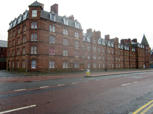
| Barque Street Tenements | 1197876 | II | Barrow Island | ||
| Brig Street Tenements | 1209653 | II | Barrow Island | ||
| Burlington House | 1197855 | II | Barrow Island | ||
| Church of St John | 1197868 | II | 1935 | Barrow Island | Island Road |
| Devonshire Buildings | 1218436 | II* | 1875 | Barrow Island | 1 of a pair of tenement blocks |
| Devonshire Buildings | 1197845 | II* | 1875 | Barrow Island | 1 of a pair of tenement blocks |
| Front Range Ado Building, Lodge, Gateway and Railings at Vickers Ship and Engineering Limited Engine | 1291983 | II | Barrow Island | ||
| General Offices, Technical/Commercial, at Vickers Ship and Engineering Limited | 1283036 | II | Barrow Island | ||
| Heavy Engineering Shop at Vickers Ship and Engineering Limited | 1197844 | II | Barrow Island | ||
| Schooner Street Tenements | 1218826 | II | Barrow Island | ||
| Ship Street Tenement | 1282850 | II | Barrow Island | ||
| Sloop Street Tenements | 1201084 | II* | 1884 | Barrow Island | |
| Steamer Street Tenements | 1282852 | II* | 1884 | Barrow Island | |
| Works Entrance Lode and Gateway at Vickers Ship and Engineering Limited Kings Gate Including Nationa | 1218444 | II | Barrow Island | ||
| No. 12, Cross Lane | 1197888 | II | Hawcoat | ||
| Chase End | 1201075 | II | Hawcoat | ||
| Drinking Fountain at Junction Wityh Abbey Road | 1209632 | II | Hawcoat | ||
| Millwood | 1283055 | II | Hawcoat | ||
| Number 17 and Attached Outbuilding | 1282845 | II | Hawcoat | ||
| Sink Fall Farmhouse with Attached Farm Buildings | 1283020 | II | Hawcoat | ||
| Thwaite Flat Farmhouse | 1218955 | II | Hawcoat | ||
| No. 32, Robert Street | 1201076 | II | Hindpool | ||
| Barclays Bank | 1209890 | II | Hindpool | ||
| Church of St James | 1197881 | II* | 1869 | Hindpool | |
| Church of St Mary of Furness | 1283023 | II | 1867 | Hindpool | Duke Street |
| College of Further Education Annexe Including Front Railings and Piers | 1292626 | II | Hindpool | ||
| Conservative Club | 1283009 | II | Hindpool | ||
| Cooke's Buildings | 1292630 | II | Hindpool | ||
| Duke of Edinburgh Hotel | 1197912 | II | Hindpool | ||
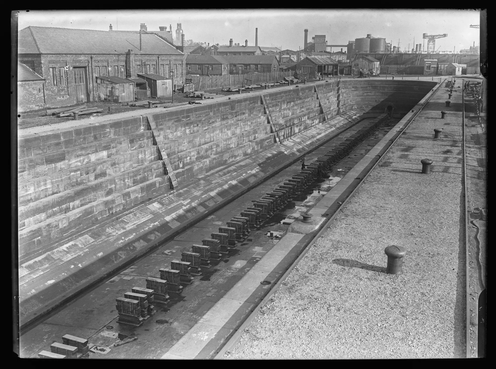
| Graving Dock | 1197847 | II | 1872 | Hindpool | North Road. Dock Museum. |
| National Westminster Bank | 1283024 | II | Hindpool | ||
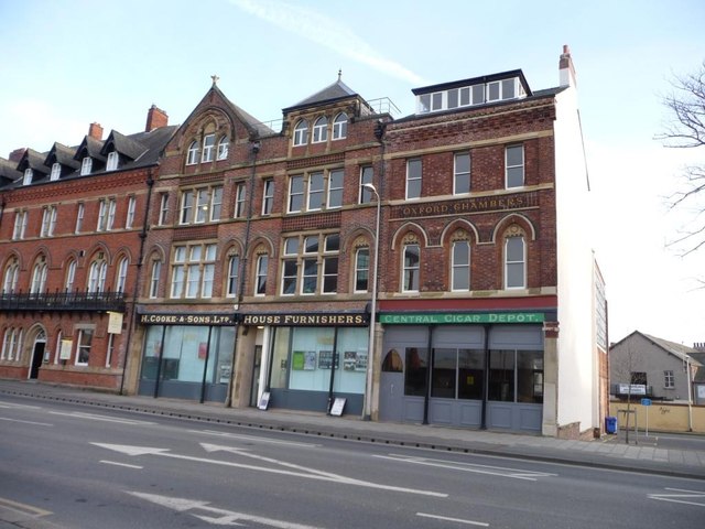
| Oxford Chambers | 1197913 | II | c.1875 | Hindpool | Abbey Street |
| Pair of K6 Telephone Kiosks Adjacent to Public Library | 1292600 | II | Hindpool | ||
| 1875 | Hindpool | By Paley and Austin. Badly damaged by fire, March 2005 | |||
| Presbytery to Church of St Mary of Furness with Wall Connecting to Church | 1197856 | II | C19th | Hindpool | Duke Street |
| Public Library, Museum and Forecourt Wall and Railings Facing Ramsden Square | 1197858 | II | Hindpool | ||
| Ramsden Hall | 1292603 | II | Hindpool | ||
| Statue of Lord Frederick Cavendish at Junction with North Road | 1292108 | II | Hindpool | ||
| Statue of Sir James Ramsden | 1210082 | II | Hindpool | ||
| Victoria Hall | 1282844 | II | Hindpool | ||
| Working Men's Club and Institute | 1197914 | II | Hindpool | ||
| No. 1, Dorcas Avenue | 1292453 | II | Newbarns | ||
| No. 19, New Barns Village | 1197867 | II | Newbarns | ||
| No. 298, Abbey Road | 1197909 | II | Newbarns | ||
| Furness Abbey Wall | 1355052 | I | Medieval | Newbarns | Abbey Approach |
| Furness Abbey, Including All Medieval Remains in Care of English Heritage | 1197906 | I | 1123 | Newbarns | |
| Hector Cottage | 1197862 | II | Newbarns | ||
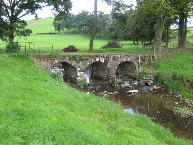
| Jubilee Bridge | 1283010 | II | 1887 | Newbarns | Road bridge over Dane Gill Beck. |
| Lodge to Crosslands | 1282843 | II | Newbarns | ||
| Malvern House | 1218219 | II | Newbarns | ||
| Manor Framhouse | 1201073 | II | Newbarns | ||
| Number 4 New Barns Village | 1291783 | II | Newbarns | ||
| Oaklands | 1209524 | II | Newbarns | ||
| Our Lady's School, Crosslands Convent | 1201072 | II | Newbarns | ||
| Park House Farmhouse | 1197851 | II* | C16th | Newbarns | Parkhouse Road |
| Sandylands Farmhouse and Attached Barn | 1218174 | II | Newbarns | ||
| West Gate Cottage | 1197869 | II | Newbarns | ||
| West Gate to Furness Abbey, Remains of | 1292045 | I | C14th | Newbarns | Manor Road |
| West Lodge to Abbey House with Attached Gatehouse and Wing Walls | 1209001 | II | Newbarns | ||
| Barn and Outbuilding Adjoining Ormsgill Farmhouse | 1197849 | II | Ormsgill | ||
| Barn Immediately to North East of Sowerby Lodge Farmhouse | 1283033 | II | Ormsgill | ||
| Barn Immediately to Rear of Sowerby Hall Farmhouse | 1283032 | II* | C16th | Ormsgill | Bank Lane. Now a house. |
| Borough Cemetery Gate House and Attached Railings | 1209811 | II | Ormsgill | ||
| Gateway and Attached Railings to Borough Cemetery at North Lodge | 1292445 | II | Ormsgill | ||
| North Lodge | 1283037 | II | Ormsgill | ||
| Ormsgill Farmhouse | 1218612 | II* | 1605 | Ormsgill | Ormsgill Lane |
| Ramsden Vault Immediately East of Crematorium (Not Included) at Borough Cemetery | 1197890 | II | Ormsgill | ||
| Roman Catholic Cemetery Chapel at Borough Cemetery | 1209845 | II | Ormsgill | ||
| Romney Cottage | 1218620 | II | Ormsgill | ||
| Sowerby Hall Farmhouse | 1197874 | II | Ormsgill | ||
| Sowerby Lodge Farmhouse | 1197875 | II | Ormsgill | ||
| Victoria Park Hotel | 1219009 | II | Parkside | ||
| War Memorial in Public Park | 1218631 | II | 1919 | Parkside | |
| No. 143, Salthouse Road | 1218773 | II | Risedale | ||
| Nos. 145 and 147, Salthouse Road | 1218775 | II | Risedale | ||
| No. 151, Salthouse Road | 1201079 | II | Risedale | ||
| Barn Immediately to West of Number 143 | 1282847 | II | Risedale | ||
| Number 153 with Adjoining Farm Buildings | 1218777 | II | Risedale | ||
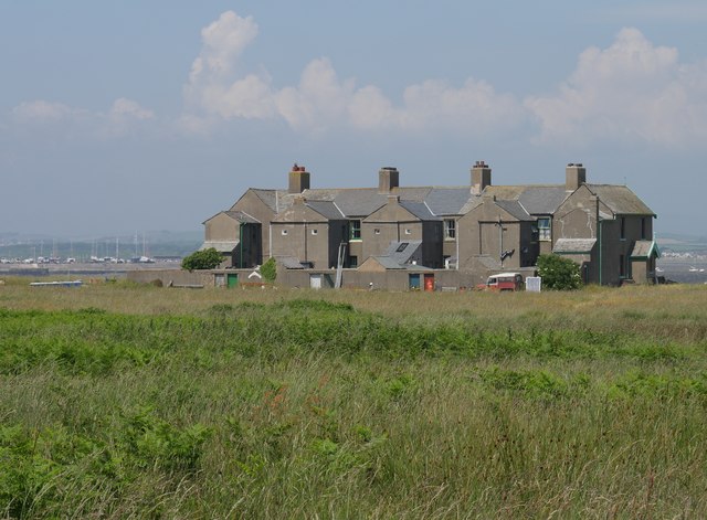
| 1-8, Piel Island | 1197898 | II | 1875 | Roosecote | Piel Island Built as Trinity House Pilot Houses. |
| Abbey Gate Cottages | 1025265 | II | Roosecote | ||
| Abbey House Hotel | 1197910 | II* | 1914 | Roosecote | Abbey Road. By Edwin Lutyens. |
| Abbey Vale | 1208939 | II | Roosecote | ||
| Barn Immediately to South West of Number 1 Roosecote | 1218149 | II | Roosecote | ||
| Barn on Roadside to North West of Stank Farmhouse | 1197903 | II | Roosecote | ||
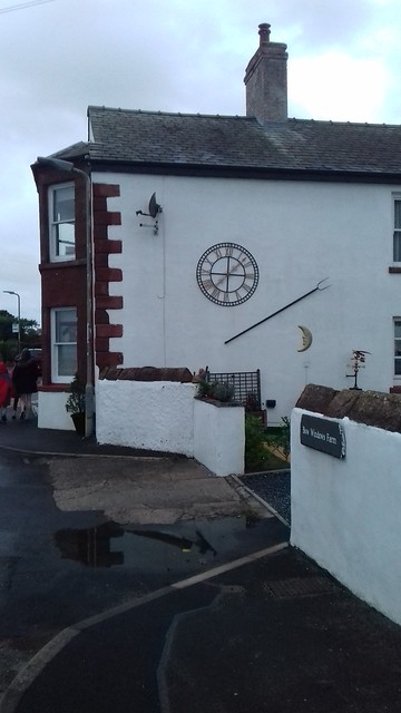
| Bow Windows Farmhouse and Attached Farm Buildings | 1218691 | II | 1654 | Roosecote | Rampside |
| Bridge over Mill Beck and Attached Gateway at Abbey Vale | 1197905 | II | Roosecote | ||
| Capella Extra Portas with Attached Walls | 1292871 | I | c1300 | Roosecote | Abbey Approach |
| Cow House and Barn with Attached Horse Engine House North East of Crofters Public House | 1292077 | II | Roosecote | ||
| Crofters Public House | 1197864 | II | Roosecote | ||
| Easatwood House | 1283021 | II | Roosecote | ||
| Engine House at Ngr Sd 2325 7080 to North East of Glenfield House | 1197901 | II | Roosecote | ||
| Entrance Gateways to Glenfield House Including Attached Side Gate to Rose Cottage | 1283006 | II | Roosecote | ||
| Former Cow House and Attached Shelter Shed Immediately North of Crofters Public House | 1197865 | II | Roosecote | ||
| Former Mine Building Immediately to North of Glenfield House | 1197902 | II | Roosecote | ||
| Furness Abbey Cottage | 1292900 | II | Roosecote | ||
| Furness Abbey, Former Custodian's Cottage | 1197908 | II | Roosecote | ||
| Gateway Adjoining Capella Extra | 1197907 | I | C16th | Roosecote | Outer gate of the abbey precinct |
| Gateway to Abbey Approach | 1292595 | II | Roosecote | ||
| Glenfield House | 1197900 | II | Roosecote | ||
| Group of 3 Former Pigsties and Midden Wall at Crofters Public House | 1292080 | II | Roosecote | ||
| Home Farmhouse and Attached Farm Buildings | 1283028 | II | Roosecote | ||
| Kitchen Garden Perimeter Wall at Home Farm | 1218276 | II | Roosecote | ||
| Moss Side Farmhouse Including Moss Side Cottage | 1197850 | II | Roosecote | ||
| North Lodge to Abbey House | 1208995 | II | Roosecote | ||
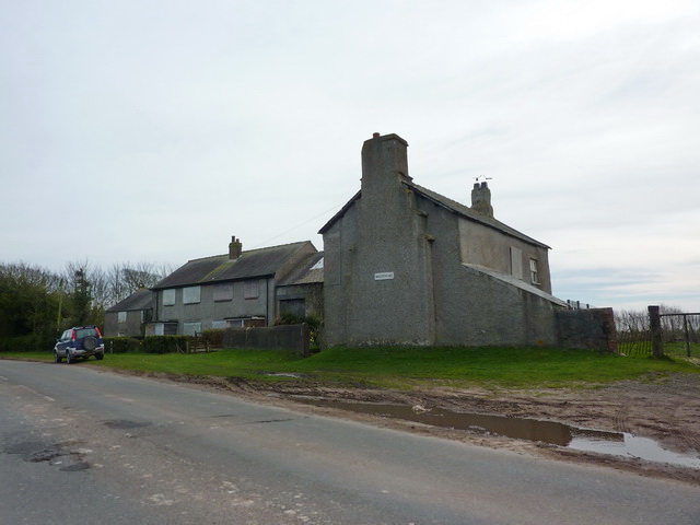
| Number 1 Moorhead Cottages and Attached Barn | 1218701 | II | 1719 | Roosecote | Rampside |
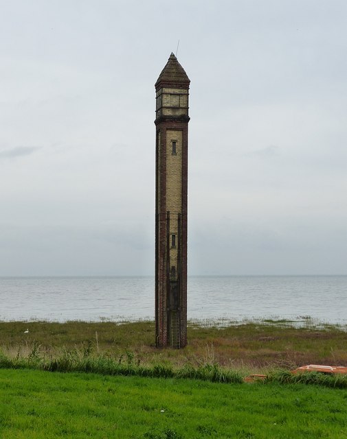
| Number 4 Leading Light on Foreshore Near Rampside Hall | 1197853 | II | 1875 | Roosecote | Rampside Lighthouse |
| Piel Castle | 1283004 | I | C14th | Roosecote | Piel Island . Scheduled Monument (1009097) |
| Rampside Hall | 1197852 | I | C17th | Roosecote | Rampside |
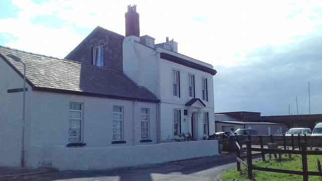
| Roa Island Hotel | 1283005 | II | C19th | Roosecote | Roa Island. Now a private house. |
| Roosecote | 1197860 | II | C17th | Roosecote | No. 1, Dungeon Lane |
| Roosecote | 1283026 | II | C17th | Roosecote | No. 2, Dungeon Lane |
| Roosecote | 1292089 | II | C17th | Roosecote | No. 3, Dungeon Lane |
| Rose Cottage | 1283007 | II | Roosecote | ||
| South Lodge at Abbotswood (Not Included) | 1218289 | II | Roosecote | ||
| Stank Farmhouse and Attached Farm Buildings | 1292910 | II | Roosecote | ||
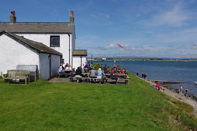
| The Abbey Tavern | 1025255 | II | Roosecote | ||
| The Concle Public House | 1218697 | II | C19th | Roosecote | Rampside |
| The Ship Inn | 1197899 | II | C18th | Roosecote | Piel Island |
| Tower House | 1201092 | II | Roosecote | ||
| Wall Enclosing Garden to Front and South Side of Crofters Public House | 1197866 | II | Roosecote | ||
| Watch Tower | 1218986 | II | 1849 | Roosecote | Roa Island. Former customs house. |
| Waver Cottage | 1291850 | II | Roosecote | ||
| No. 1, North Scale | 1218588 | II | Walney North | ||
| No. 14, North Scale | 1283056 | II | Walney North | ||
| No. 19, North Scale | 1197848 | II | Walney North | ||
| Church of St Mary | 1291841 | II | 1908 | Walney North | Vickerstown |
| Farm Buildings Immediately to South East of Number 14 | 1218594 | II | Walney North | ||
| Number 20 with Attached Front Garden Wall and Attached Barn and Shippons | 1218608 | II | Walney North | ||
| Number 28 with Attached Stables | 1283057 | II | Walney North | ||
| No. 19, Biggar Village | 1197880 | II | C18th | Walney South | Biggar Village, Walney Island |
| Barn Facing South Side of Queen's Arms Hotel | 1209629 | II | C18th | Walney South | Biggar Village, Walney Island |
| Barn to Souith East of Number 19 | 1292568 | II | C18th | Walney South | Biggar Village, Walney Island |
| Hill Farmhouse | 1209612 | II | C17th | Walney South | Biggar Village, Walney Island |
| Manor Farmhouse | 1209592 | II | C18th | Walney South | Biggar Village, Walney Island |
| New Inn and Attached Buildings | 1283035 | II | 1758 | Walney South | Biggar Village. House, former inn. |
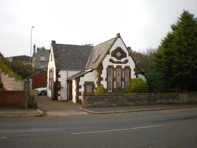
| Old School House | 1218677 | II | 1856 | Walney South | Vickerstown, Promenade |
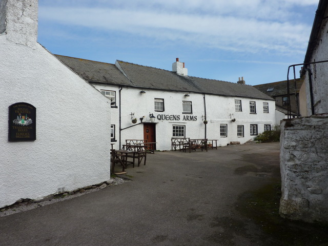
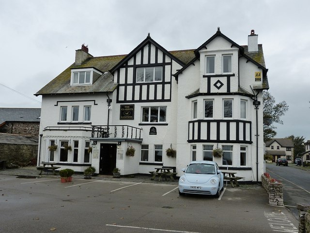
| Queen's Arms Hotel | 1292535 | II | C17th | Walney South | Biggar Village, Walney Island |
| Rainbow Cottage | 1197879 | II | C19th | Walney South | Biggar Village, Walney Island |
| Range of Farm Buildings Attached to Number 2 | 1197878 | II | C17th | Walney South | Biggar Village, Walney Island |
| South End Farmhouse and Attached Farm Buildings | 1218165 | II | 1764 | Walney South | Hare Lane, Walney Island |
| Squire's Cottage | 1209598 | II | C18th | Walney South | Biggar Village, Walney Island |
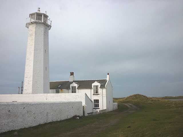
| Walney Lighthouse with Two Attached Cottages and Outbuildings | 1218858 | II* | 1804 | Walney South | Walney Island |
| Barrow Park | 1437665 | II | 1915 | Parkside | Listed Park and Garden |
| Furness Abbey Savignac and Cistercian monasteries: precinct wall, great gatehouse, 'chapel outside the gates', south west gateway and earthworks. | 1010014 | n/a | Newbarns | Scheduled Monument | |
| Bow Bridge medieval multi-span bridge | 1011245 | n/a | C15th | Newbarns | Scheduled Monument |
| Castle House Hotel | not listed | n/a | C19th | Walney | Biggar Bank, Walney Island |
| Church of St Michael | not listed | n/a | c.1840 | Roosecote | Rampside |
| Clarkes Hotel | not listed | n/a | 1913 | Roosecote | Rampside |
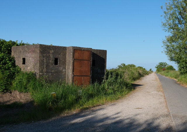
| Pillboxes by Cavendish Dock | not listed | n/a | c.1940 | Central | Cavendish Dock |
Primary source: the National Heritage List for England - NHLE is the register of nationally protected historic buildings and sites in England, including listed buildings, scheduled monuments, protected wrecks, registered parks and gardens, and battlefields. The list is maintained by Historic England. Check NHLE for updates and new entries. Secondary sources: British Listed Buildings.
Co-Curate Page
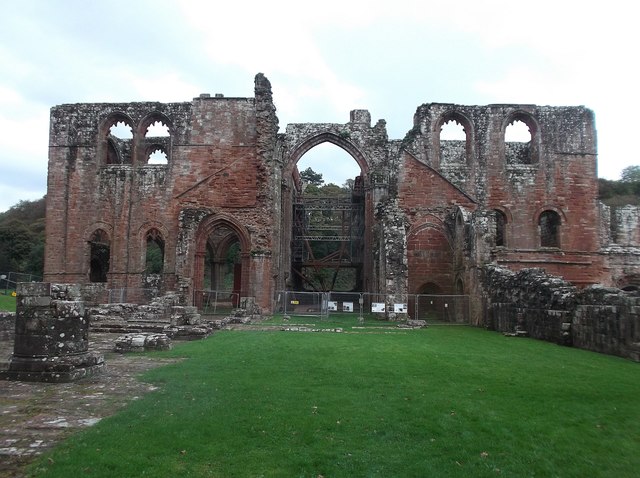
Furness Abbey
- Overview About Furness Abbey Map Street View The substantial ruins of Furness Abbey are located in Barrow-in-Furness, and under the care of English Heritage. Furness Abbey was founded in 1123 …
Co-Curate Page
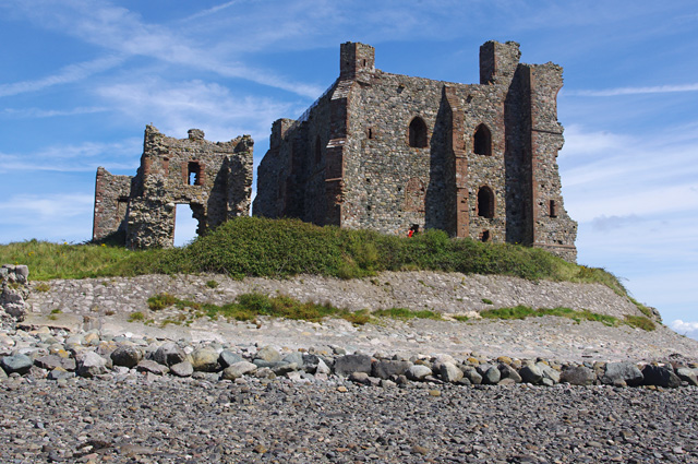
Piel Castle
- Overview About Piel Castle Map Street View Piel Castle, also known as Fouldry Castle or the Pile of Fouldray, is a castle situated on the south-eastern point of Piel …
Co-Curate Page
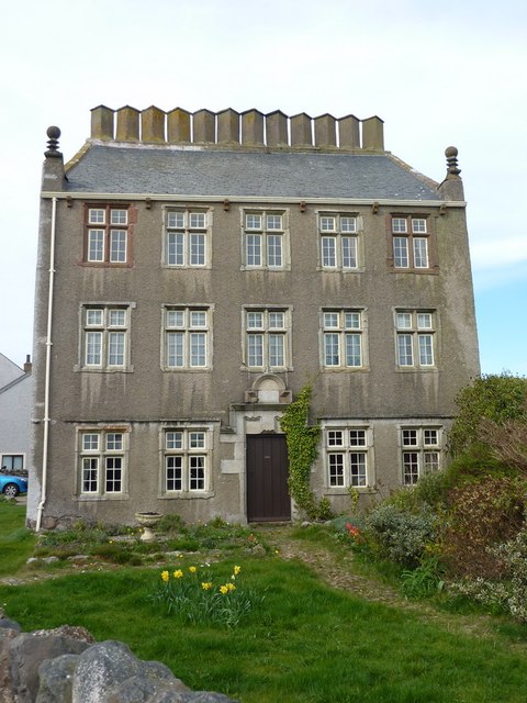
Rampside Hall
- Overview About Rampside Hall Map Street View Rampside Hall in Rampside, was built in the late 17th Century for the Knype family, on the site of an earlier house, recorded …
Co-Curate Page
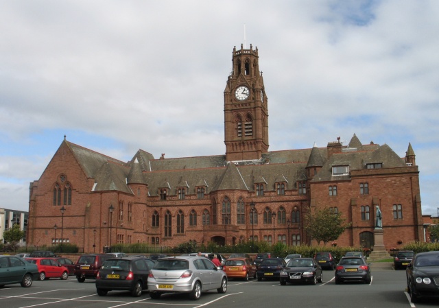
Town Hall
- Overview About the Town Hall Map Street View The Town Hall in Barrow-in-Furness was built from 1882-1887, designed in a Neo-Gothic style, by WH Lynn of Belfast. It was opened …
Co-Curate Page
Devonshire Buildings, Barrow Island
- Overview Map Street View The Devonshire Buildings are two imposing sandstone tenement blocks located on Michaelson Road on Barrow Island. They were originally built in c.1875 to house workers at …
Co-Curate Page
Church of St James
- Overview About St James' Church Map Street View St. James Church located on Blake Street in Barrow-in-Furness, belongs to the Church of England's Diocese of Carlisle within the ecclesiastical …
Co-Curate Page
Walney Lighthouse
- Overview About Walney Lighthouse Map Street View Walney Lighthouse is a functioning lighthouse located on Walney Island in Barrow-in-Furness, Cumbria, England. The current building dates to the early 19th-century …
Co-Curate Page
Bow Windows Farm
- Overview Map Street View Bow Windows Farmhouse in Rampside dates from 1654, and was extended in the18th century and altered 19th centry. The associated farm buildings are mid 18th century.[1] …
Co-Curate Page
Church of St Mary, Vickerstown
- Overview About St Mary's Church Map Street View The Church of St Mary the Virgin is the Parish Church of Walney Island, located in Vickerstown in Barrow-in-Furness. The current church …
Co-Curate Page
Former Roa Island Hotel
- Overview Map Street View The former Roa Island Hotel (originally called the Pier Hotel), on Roa Island, was built in the mid-late 19th century. At that time, there was a …
Co-Curate Page
Moorhead Cottages
- Overview Map Street View Moorhead Cottages are located near Barrow-in-Furness and about a mile and a half from the village of Rampside. Moorhead farmhouse and attached barn are dated 1719 …
Co-Curate Page
Lighthouse
- Overview About Rampside Lighthouse Map Street View The lighthouse on the foreshore at Rampside was built in 1875. It was number 4 of 13 leading light navigation beacons built in …
Co-Curate Page
Watch Tower & Former Customs House
- Overview Map Street View This former Customs House and Watch Tower is located at the end of Tower Street on Roa Island. The building dates from 1849; it is now …

Co-Curate Page
Church of St George
- Overview About St George's Church Map Street View St George's Church is located St George's Square, by the corner of Church Street and Salthouse Road in Barrow-in-Furness. The church was …
Co-Curate Page
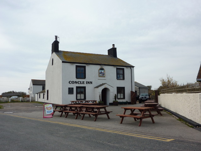
Concle Inn
- Overview Map Street View The Concle Inn is a public house located on Roa Island Road in Rampside. The pub dates from the early 19th century and is situated close …
Co-Curate Page
Ship Inn, Piel Island
- Overview About the Ship Inn Map Street View The Ship Inn is a public house and resturant on Piel Island. It is probably of 18th century in origin, then rebuilt …
Co-Curate Page
Trinity House Pilot Houses, Piel Island
- Overview Map Street View The Trinity House Pilot Houses on Piel Island are a terrace of 8 cottages, originally built in 1875 for the Duke of Buccleuch. They were used …
Co-Curate Page
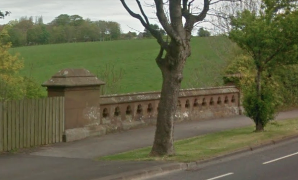
Jubilee Bridge over Dane Gill Beck
- Overview Map Street View Jubilee Bidge, which carries Abbey Road over Dane Gill Beck, in Barrow-in-Furness, was built in c.1887 and named to commemorate Queen Victoria's golden jubilee.[1] The bridge …
Co-Curate Page
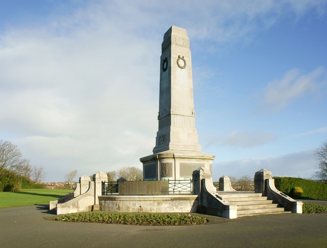
Barrow Cenotaph
- Overview Map Street View The Cenotaph in Barrow-in-Furness is located in Barrow Park. It was unveiled on the 11th of November 1921 by Field Marshall Sir William R Robertson and …
Co-Curate Page
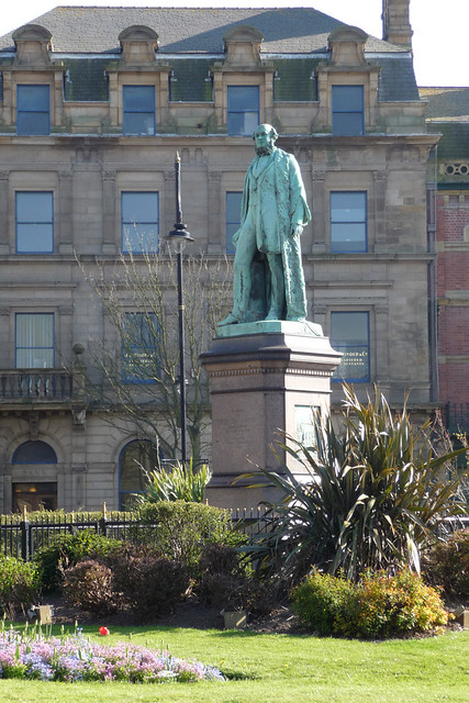
Statue of Henry Schneider
- Overview Map Street View Henry William Schneider (1817 - 1887) was an industrialist, and politician, who played a leading role in the development of Barrow-in-Furness. This statue of Schneider, sculptured …
Co-Curate Page
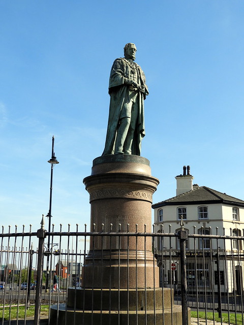
Statue of James Ramsden, Barrow-in-Furness
- Overview Map Street View This statue of Sir James Ramsden (1822-1896) is located on Ramsden Square at the intersection of Duke Street and Abbey Road in Barrow-in-Furness. Ramsden was an …
Co-Curate Page
No 4 Duke Street, Barrow
- Overview Map Street View No. 4 Duke Street in Barrow-in-Furness was built in c.1900. Originally built as a house, the building now hosts the NHS Duke Street Surgery. The building …
Co-Curate Page
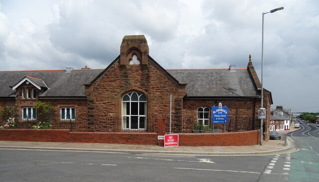
St George's CofE School
- Overview Map Street View St George's Church of England School is located by the junction of School Street and Salthouse Road in Barrow-in-Furness. It is a voluntary controlled school with …

Co-Curate Page
John Whinnerah Institute
- Overview Map Street View The former John Whinnerah Institute building is located by the junction of Abbey Road and Hindpool Road in Barrow-in-Furness. The Art Deco style building was built …
Co-Curate Page
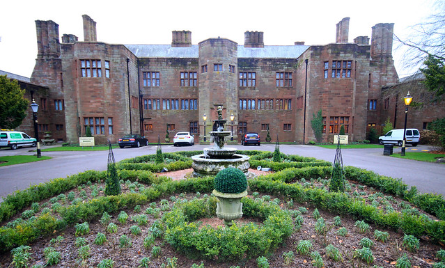
Abbey House Hotel, Barrow in Furness
- Overview Map Street View Abbey House Hotel and Gardens are located close to Furness Abbey on Abbey Road in Barrow in Furness. The hotel was originally built as a mansion …
Co-Curate Page
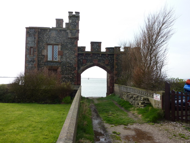
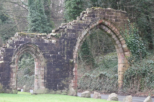
Capella Extra Portas
- Overview Map Street View Inside Capella Extra Portas is a ruined chapel, built in c.1300, which is located on Abbey Approach - the entrance to Furness Abbey in Barrow-in-Furness. The …
Co-Curate Page
Gateway adjoining Capella Extra Portas
- Overview Map Street View The Gateway (a Gothic carriage arch and separate pedestrian gateway) to the abbey precinct of Furness Abbey, is located on Abbey Approach, Barrow-in-Furness. The gateway is …
Co-Curate Page
Church of St John the Evangelist, Barrow Island
- Overview Map Street View The Church of St John the Evangelist is located on Island Road on Barrow Island in Barrow-in-Furness. The distinctive Byzantine-style church, by Paget and Seeley, was built …
Co-Curate Page
Old Fire Station, Abbey Road
- Overview Map Street View Central Fire Station on Abbey Road in Barrow-in-Furness is dated 1911 and was built by Burmantofts of Leeds, and cost £6,000. The station opened on the …
Co-Curate Page
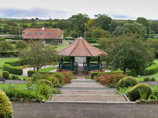
Barrow Park
- Overview Map Street View In the Park Barrow Park is a 45-acre public park in Barrow-in-Furness, accessed from Abbey Road, Park Drive, Park Avenue and Greengate Street. "A new public …
Co-Curate Page
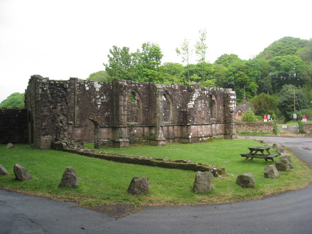
Bow Bridge, near Furness Abbey
- Overview Map Street View Bow Bridge is a 15th Century multi-span bridge over Mill Beck, located about ¼ mile south east of Furness Abbey. It was built by the monks …
Co-Curate Page
Oxford Chambers, Abbey Road
- Overview Map Street View Oxford Chambers is No.100, Abbey Road in Barrow-in-Furness. These were commercial buildings of c.1875. Oxford Chambers are Grade II listed on the National Heritage List for …
Co-Curate Page
The Queens Arms, Biggar
- Overview Map Street View The Queens Arms is a public house located in Biggar Village on Walney Island. The building dates from the 17th century, with later additions. The Queens …
Co-Curate Page
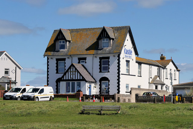
Castle House, Biggar Bank
- Overview Map Street View The Castle House is a hotel and public house located on Biggar Bank Road, Biggar Bank on Waney Island. The hotel was built sometime between 1873 …
Co-Curate Page
Church of St Mary of Furness, Barrow
- Overview Map Street View The Church of St Mary of Furness is located on Duke Street in Barrow-in-Furness. This Catholic church was built 1866-1867, designed in a Neo-Gothic style, by …
Co-Curate Page
The Old School House, Vickerstown
- Overview Map Street View The Old School House is located on the Pomenade, immediately south of St Mary's Church, in Vickerstown, Walney Island. The school was built in 1856, to …
Co-Curate Page
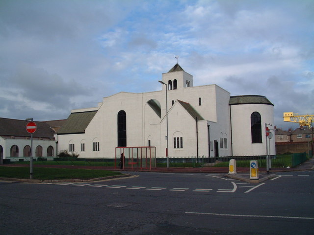
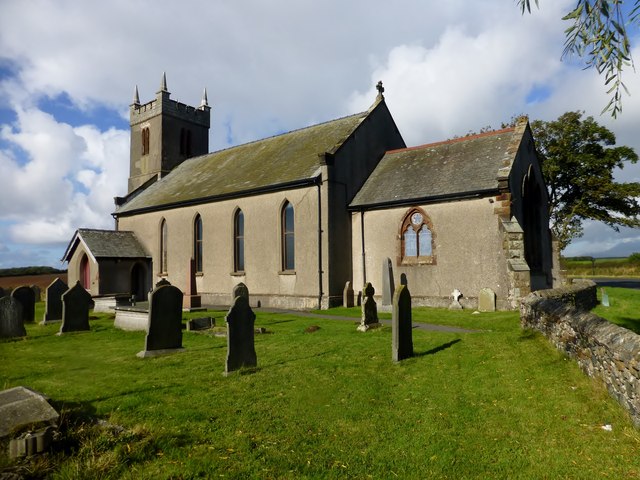
Church of St Michael
- Overview Map Street View St Michael's Church is located on the A5087 road over half a mile north of the village of Rampside, Cumbria. The present Church was built in …
Co-Curate Page
Clarke's Hotel
- Overview Map Street View The Clarkes is a hotel, restaurant and bar located off Roa Island Road in Rampside. A date stone above the door of The Clarkes shows two dates; …
Co-Curate Page
Pillboxes by Cavendish Dock
- There are pillboxes and other wartime defences along the causeway road between Cavendish Dock and Roosecote Sands.

Co-Curate Page
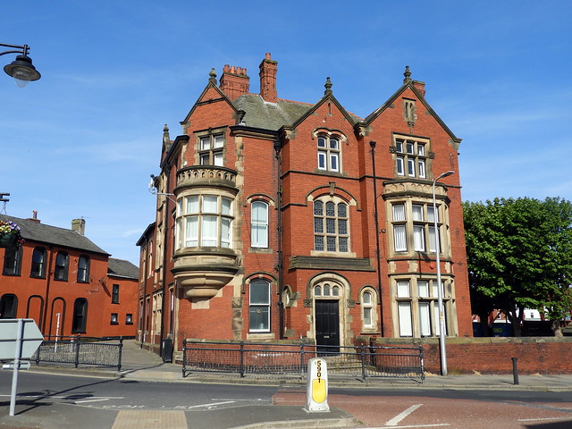
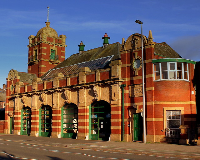
Hotel Majestic, Barrow-In-Furness
- Overview Map Street View Hotel Majestic is located at the intersection of Duke Street and Michaelson Road, by Schnider Square, in Barrow-In-Furness. The buildig is dated 'HT 1904' and built …
Co-Curate Page
Graving Dock
- Overview Map Street View The Graving Dock in Barrow-in-Furness is a historic Victorian dry dock, that is now the foundation for the Dock Museum. The dock is an enclosed basin …

Co-Curate Page
Furness Abbey
- Overview About Furness Abbey Map Street View The substantial ruins of Furness Abbey are located in Barrow-in-Furness, and under the care of English Heritage. Furness Abbey was founded in 1123 …
Co-Curate Page
Piel Castle
- Overview About Piel Castle Map Street View Piel Castle, also known as Fouldry Castle or the Pile of Fouldray, is a castle situated on the south-eastern point of Piel …
Co-Curate Page
Rampside Hall
- Overview About Rampside Hall Map Street View Rampside Hall in Rampside, was built in the late 17th Century for the Knype family, on the site of an earlier house, recorded …
Co-Curate Page
Town Hall
- Overview About the Town Hall Map Street View The Town Hall in Barrow-in-Furness was built from 1882-1887, designed in a Neo-Gothic style, by WH Lynn of Belfast. It was opened …
Co-Curate Page
Devonshire Buildings, Barrow Island
- Overview Map Street View The Devonshire Buildings are two imposing sandstone tenement blocks located on Michaelson Road on Barrow Island. They were originally built in c.1875 to house workers at …
Co-Curate Page
Church of St James
- Overview About St James' Church Map Street View St. James Church located on Blake Street in Barrow-in-Furness, belongs to the Church of England's Diocese of Carlisle within the ecclesiastical …
Co-Curate Page
Walney Lighthouse
- Overview About Walney Lighthouse Map Street View Walney Lighthouse is a functioning lighthouse located on Walney Island in Barrow-in-Furness, Cumbria, England. The current building dates to the early 19th-century …
Co-Curate Page
Bow Windows Farm
- Overview Map Street View Bow Windows Farmhouse in Rampside dates from 1654, and was extended in the18th century and altered 19th centry. The associated farm buildings are mid 18th century.[1] …
Co-Curate Page
Church of St Mary, Vickerstown
- Overview About St Mary's Church Map Street View The Church of St Mary the Virgin is the Parish Church of Walney Island, located in Vickerstown in Barrow-in-Furness. The current church …
Co-Curate Page
Former Roa Island Hotel
- Overview Map Street View The former Roa Island Hotel (originally called the Pier Hotel), on Roa Island, was built in the mid-late 19th century. At that time, there was a …
Co-Curate Page
Moorhead Cottages
- Overview Map Street View Moorhead Cottages are located near Barrow-in-Furness and about a mile and a half from the village of Rampside. Moorhead farmhouse and attached barn are dated 1719 …
Co-Curate Page
Lighthouse
- Overview About Rampside Lighthouse Map Street View The lighthouse on the foreshore at Rampside was built in 1875. It was number 4 of 13 leading light navigation beacons built in …
Co-Curate Page
Watch Tower & Former Customs House
- Overview Map Street View This former Customs House and Watch Tower is located at the end of Tower Street on Roa Island. The building dates from 1849; it is now …
Co-Curate Page
Church of St George
- Overview About St George's Church Map Street View St George's Church is located St George's Square, by the corner of Church Street and Salthouse Road in Barrow-in-Furness. The church was …
Co-Curate Page
Concle Inn
- Overview Map Street View The Concle Inn is a public house located on Roa Island Road in Rampside. The pub dates from the early 19th century and is situated close …
Co-Curate Page
Ship Inn, Piel Island
- Overview About the Ship Inn Map Street View The Ship Inn is a public house and resturant on Piel Island. It is probably of 18th century in origin, then rebuilt …
Co-Curate Page
Trinity House Pilot Houses, Piel Island
- Overview Map Street View The Trinity House Pilot Houses on Piel Island are a terrace of 8 cottages, originally built in 1875 for the Duke of Buccleuch. They were used …
Co-Curate Page
Jubilee Bridge over Dane Gill Beck
- Overview Map Street View Jubilee Bidge, which carries Abbey Road over Dane Gill Beck, in Barrow-in-Furness, was built in c.1887 and named to commemorate Queen Victoria's golden jubilee.[1] The bridge …
Co-Curate Page
Barrow Cenotaph
- Overview Map Street View The Cenotaph in Barrow-in-Furness is located in Barrow Park. It was unveiled on the 11th of November 1921 by Field Marshall Sir William R Robertson and …
Co-Curate Page
Statue of Henry Schneider
- Overview Map Street View Henry William Schneider (1817 - 1887) was an industrialist, and politician, who played a leading role in the development of Barrow-in-Furness. This statue of Schneider, sculptured …
Co-Curate Page
Statue of James Ramsden, Barrow-in-Furness
- Overview Map Street View This statue of Sir James Ramsden (1822-1896) is located on Ramsden Square at the intersection of Duke Street and Abbey Road in Barrow-in-Furness. Ramsden was an …
Co-Curate Page
No 4 Duke Street, Barrow
- Overview Map Street View No. 4 Duke Street in Barrow-in-Furness was built in c.1900. Originally built as a house, the building now hosts the NHS Duke Street Surgery. The building …
Co-Curate Page
St George's CofE School
- Overview Map Street View St George's Church of England School is located by the junction of School Street and Salthouse Road in Barrow-in-Furness. It is a voluntary controlled school with …
Co-Curate Page
John Whinnerah Institute
- Overview Map Street View The former John Whinnerah Institute building is located by the junction of Abbey Road and Hindpool Road in Barrow-in-Furness. The Art Deco style building was built …
Co-Curate Page
Abbey House Hotel, Barrow in Furness
- Overview Map Street View Abbey House Hotel and Gardens are located close to Furness Abbey on Abbey Road in Barrow in Furness. The hotel was originally built as a mansion …
Co-Curate Page
Capella Extra Portas
- Overview Map Street View Inside Capella Extra Portas is a ruined chapel, built in c.1300, which is located on Abbey Approach - the entrance to Furness Abbey in Barrow-in-Furness. The …
Co-Curate Page
Gateway adjoining Capella Extra Portas
- Overview Map Street View The Gateway (a Gothic carriage arch and separate pedestrian gateway) to the abbey precinct of Furness Abbey, is located on Abbey Approach, Barrow-in-Furness. The gateway is …
Co-Curate Page
Church of St John the Evangelist, Barrow Island
- Overview Map Street View The Church of St John the Evangelist is located on Island Road on Barrow Island in Barrow-in-Furness. The distinctive Byzantine-style church, by Paget and Seeley, was built …
Co-Curate Page
Old Fire Station, Abbey Road
- Overview Map Street View Central Fire Station on Abbey Road in Barrow-in-Furness is dated 1911 and was built by Burmantofts of Leeds, and cost £6,000. The station opened on the …
Co-Curate Page
Barrow Park
- Overview Map Street View In the Park Barrow Park is a 45-acre public park in Barrow-in-Furness, accessed from Abbey Road, Park Drive, Park Avenue and Greengate Street. "A new public …
Co-Curate Page
Bow Bridge, near Furness Abbey
- Overview Map Street View Bow Bridge is a 15th Century multi-span bridge over Mill Beck, located about ¼ mile south east of Furness Abbey. It was built by the monks …
Co-Curate Page
Oxford Chambers, Abbey Road
- Overview Map Street View Oxford Chambers is No.100, Abbey Road in Barrow-in-Furness. These were commercial buildings of c.1875. Oxford Chambers are Grade II listed on the National Heritage List for …
Co-Curate Page
The Queens Arms, Biggar
- Overview Map Street View The Queens Arms is a public house located in Biggar Village on Walney Island. The building dates from the 17th century, with later additions. The Queens …
Co-Curate Page
Castle House, Biggar Bank
- Overview Map Street View The Castle House is a hotel and public house located on Biggar Bank Road, Biggar Bank on Waney Island. The hotel was built sometime between 1873 …
Co-Curate Page
Church of St Mary of Furness, Barrow
- Overview Map Street View The Church of St Mary of Furness is located on Duke Street in Barrow-in-Furness. This Catholic church was built 1866-1867, designed in a Neo-Gothic style, by …
Co-Curate Page
The Old School House, Vickerstown
- Overview Map Street View The Old School House is located on the Pomenade, immediately south of St Mary's Church, in Vickerstown, Walney Island. The school was built in 1856, to …
Co-Curate Page
Church of St Michael
- Overview Map Street View St Michael's Church is located on the A5087 road over half a mile north of the village of Rampside, Cumbria. The present Church was built in …
Co-Curate Page
Clarke's Hotel
- Overview Map Street View The Clarkes is a hotel, restaurant and bar located off Roa Island Road in Rampside. A date stone above the door of The Clarkes shows two dates; …
Co-Curate Page
Pillboxes by Cavendish Dock
- There are pillboxes and other wartime defences along the causeway road between Cavendish Dock and Roosecote Sands.
Co-Curate Page
Hotel Majestic, Barrow-In-Furness
- Overview Map Street View Hotel Majestic is located at the intersection of Duke Street and Michaelson Road, by Schnider Square, in Barrow-In-Furness. The buildig is dated 'HT 1904' and built …


