Topics > Heritage Sites > Conservation Areas
Conservation Areas
Conservation areas have special restrictions imposed on development in order to retain the character of the area. Conservation areas were first introduced by the Civic Amenities Act 1967, which gave local councils the power to designate areas which people generally feel have a special character worth protecting or enhancing.
Tyne and Wear
- Axwell Park
- Birtley
- Blaydon Bank
- Bradley Park
- Bridges (Gateshead)
- Chowdene
- Clara Vale
- Coatsworth
- Crow Hall (Felling)
- Gibside
- Lamesley
- Lintzford
- Low Fell
- Marley Hill
- Path Head
- Ravensworth
- Rowlands Gill
- Ryton
- Saltwell
- Sheriff Hill
- Walker Terrace / Regent Street (Gateshead)
- Whickham
- Brandling Village
- Central (Newcastle)
- Framlington Place
- Gosforth
- Jesmond Dene
- Leazes
- Northumberland Gardens
- Ouseburn
- South Jesmond
- Summerhill Square
- St Nicholas Hospital
- Walbottle
- Backworth
- Benton
- Camp Terrace
- Cullercoats
- Earsdon
- Fish Quay
- Killingworth Village
- Longbenton
- Monkseaton
- Northumberland Square
- Preston Park
- Sacred Heart, Wideopen
- St Mary's Island
- St Peter's
- The Green, Wallsend
- Tynemouth Village
- Cleadon
- Cleadon Hills
- East Boldon
- Hebburn Hall
- Mariners' Cottages
- Mill Dam
- Monkton
- St Paul's (Jarrow)
- West Boldon
- Westoe
- Whitburn
- Ashbrooke
- Bishopwearmouth
- Nesham Place (Houghton-le-Spring)
- Newbottle
- Old Sunderland
- Old Sunderland Riverside
- Roker Park
- Ryhope Village
- Silksworth Hall
- St. Michael's (Houghton-le-Spring)
- Sunniside
- The Cedars
- Washington Village
- Whitburn Bents
- Acomb
- Allendale
- Alnmouth
- Alnwick
- Amble
- Bamburgh
- Beadnell
- Bedlington
- Belford
- Belsay
- Berwick-upon-Tweed
- Blanchland
- Blyth Bondicar Terrace
- Blyth Heritage
- Blyth Central
- Bothal
- Broomley
- Cambo
- Capheaton
- Chatton
- Corbridge
- Cramlington Village
- Eglingham
- Embleton
- Felton
- Glanton
- Great Bavington
- Great Whittington
- Guyzance
- Haltwhistle
- Haydon Bridge
- Hexham
- High Callerton
- Holy Island
- Holywell
- Horsley
- Humshaugh
- Kirknewton
- Kirkwhelpington
- Lesbury
- Longhirst
- Longhorsley
- Matfen
- Middleton
- Morpeth
- Netherwitton
- Newbiggin-by-the-Sea
- Newbrough
- Newton
- Newton-on-the-Moor
- Norham
- North Sunderland
- Ovingham
- Ovington
- Ponteland
- Rock
- Rothbury
- Seahouses
- Seaton Delaval
- Shotley
- Spittal
- Stamfordham
- Tweedmouth
- Wall
- Warkworth
- West Thirston
- Whalton
- Whittingham
- Whitton
- Wooler
Darlington
- Bishopton
- Coatham Mundeville
- Cockerton Village
- Darlington Town Centre
- Denton
- Haughton-le-Skerne
- Heighington
- High Coniscliffe
- Hurworth
- Middleton One Row
- Northgate
- Parkgate
- Piercebridge
- Sadberge
- Summerhouse
- Victoria Embankment
- West End, Darlington
Hartlepool
Middlesbrough
- Acklam Hall
- Albert Park and Linthorpe Road
- Middlesbrough Historic Quarter
- Linthorpe
- Marton Village and The Grove
- Nunthorpe and Poole
- Ormesby Hall *
- Stainton & Thornton
Note: * the part of Ormesby Hall Conservation area which is to the north of the B1380 road is in the Middlesbrough Council area, whilst the larger part, to the south of the B1380 is in the Redcar and Cleveland Council area.
Redcar & Cleveland
- Brotton
- Coatham
- Guisborough
- Hutton Lowcross
- Kirkleatham
- Liverton Village
- Loftus
- Marske-by-the-Sea
- Moorsholm
- Ormesby Hall
- Saltburn-by-the-Sea
- Skelton
- Skinningrove
- Staithes *
- Upleatham
- Wilton
- Yearby
Note: * Staithes Conservation Area is managed by the North York Moors National Park Authority (the Cowbar area of Staithes is in Redcar & Cleveland Council area, the rest of the village being in North Yorkshire Council area)
Stockton-on-Tees
- Annfield Plain
- Aycliffe Village
- Barnard Castle
- Barningham
- Beamish Burn
- Bishop Auckland
- Bishop Middleham
- Blackhill
- Bolam
- Bowburn
- Bowes
- Brancepeth
- Brandon
- Brusselton
- Burnhall
- Burnopfield
- Castle Eden
- Chester-le-Street
- Cleatlam
- Cockfield
- Cockton Hill
- Cornforth
- Cornsay
- Cotherstone
- Cowshill
- Crook
- Durham City
- Easington Village
- East Blackdene
- Eastgate
- Ebchester
- Edmundbyers
- Eggleston
- Esh
- Frosterley
- Gainford
- Greta Bridge
- Hardwick Park
- Hawthorn
- Headlam
- Hett
- Hilton
- Holywell
- Hunstanworth
- Hunwick
- Ingleton
- Ireshopeburn Newhouse and West Blackdene
- Iveston
- Kirk Merrington
- Lanchester
- Langton
- Lartington
- Lintzford
- Little Newsham
- Low Westwood
- Mainsforth
- Medomsley
- Mickleton
- Middleton-in-Teesdale
- Middridge
- Mordon
- Muggleswick
- Newbiggin
- Old Cassop
- Pittington Hallgarth
- Plawsworth
- Romaldkirk
- Satley
- Seaham
- Sedgefield
- Shadforth
- Sherburn
- Sherburn House
- Shildon
- Shincliffe
- Shotley Bridge
- St John's Chapel
- Staindrop
- Stanhope
- Sunderland Bridge
- Tanfield
- Thornley
- Trimdon Village
- Tudhoe
- Wackerfield
- Wearhead
- West Auckland
- Westgate
- Whitworth
- Whorlton
- Windlestone
- Witton-le-Wear
- Wolsingham
Cumberland Council Area
Note: conservation areas marked * are managed by the Lake District National Park Authority.
- Allonby
- Beckermet
- Blennerhasset
- Blindcrake *
- Botchergate
- Bowness-on-Solway
- Brampton
- Brisco
- Burgh by Sands
- Caldbeck *
- Carlisle City Centre
- Carlisle-Settle Railway (north section)
- Chatsworth Square and Portland Square (Carlisle)
- Cleator Moor
- Cockermouth
- Cumrew
- Dalston
- Egremont
- Gamelsby
- Great Corby
- Greysouthen
- Hayton
- Hesket Newmarket *
- Holme Head
- Keswick *
- Kirkbampton
- Longburgh
- Longtown
- Maryport
- Mawbray
- Millom
- Papcastle
- Port Carlisle
- Ravenglass *
- Rickerby
- St Bees
- St. Michaels, Workington
- Silloth
- Stanwix
- Tarraby
- Torpenhow
- Victoria Road, Botcherby
- Warwick-on-Eden
- Westnewton
- West Curthwaite
- Wetheral
- Whitehaven Corkickle
- Whitehaven Hensingham
- Whitehaven Town Centre
- Wigton
- Wood Street, Botcherby
- Workington, Brow Top
- Workington, Portland Square
- Workington, St Michaels
Westmorland & Furness Council Area
Note: conservation areas marked * are managed by the Lake District National Park Authority.
Note: conservation areas marked + are managed by the Yorkshire Dales National Park Authority.
- Alston
- Ambleside *
- Appleby
- Askham *
- Bampton *
- Bampton Grange *
- Barrow Central
- Barrow Island
- Beetham
- Biggar Village
- Bowness-on-Windermere *
- Broughton-in-Furness *
- Burton in Kendal
- Cartmel
- Church Brough
- Crosby Garrett +
- Crosby Ravensworth +
- Dalton-in-Furness
- Dent +
- Dufton
- Edenhall
- Far Sawrey *
- Farfield Mill +
- Furness Abbey
- Gamblesby
- Garrigill
- Grange-Over-Sands
- Grasmere Town End *
- Grasmere Village *
- Great Asby +
- Great Salkeld
- Hartsop *
- Hawkshead *
- Helton *
- Heversham
- Hunsonby
- Ireleth
- Kendal
- Kings Meaburn
- Kirkby Stephen
- Kirkby Lonsdale
- Kirkoswald
- Lowther *
- Maulds Meaburn +
- Milburn
- Milnthorpe
- Near Sawrey *
- Newland Furnace
- North Scale
- North Vickerstown
- Orton +
- Penrith
- Penrith New Streets
- Ravenstonedale +
- Rydal Conservation Area *
- Sedburgh Conservation Area +
- Settle to Carlisle Railway (south section)
- Skirwith
- St George’s Square
- South Vickerstown
- Staveley *
- Temple Sowerby
- The Green, Lindal
- Troutbeck *
- Ulverston
- Windermere Conservation Area *

Co-Curate Page
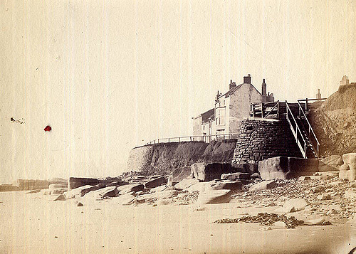
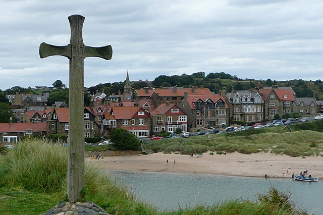
St Mary's Island and Lighthouse
- A Brief History About the Island About the Lighthouse Map Street View St Mary’s Island is a tidal island located off Curry's Point to the north of Whitley Bay, accessed by …
Co-Curate Page
Backworth
- Overview About Backworth Map Street View Backworth is a village in the metropolitan borough of North Tyneside in the county of Tyne and Wear, England, about 3 1⁄2 miles …
Co-Curate Page
Saltburn-by-the-Sea
- Overview About Saltburn Map Street View Saltburn-by-the-Sea is a costal town in Redcar and Cleveland, historically part of the North Riding of Yorkshire. Saltburn is situated by Skelton Beck and …
Co-Curate Page
Gibside
- Overview About Gibside Map Street View Gibside is a country estate, set amongst the peaks and slopes of the Derwent Valley, between Rowlands Gill, Tyne and Wear and Burnopfield, …
Co-Curate Page
Walbottle
- Overview About Walbottle Map Street View Walbottle is a village in Tyne and Wear. It is a western suburb of Newcastle upon Tyne. The village name, recorded in 1176 …

Co-Curate Page
Bishopwearmouth
- Overview About Bishopwearmouth Map Street View Bishopwearmouth is an area in Sunderland, North East England. Bishopwearmouth was one of the original three settlements on the banks of the river …
Co-Curate Page
North Shields Fish Quay
- Overview About the Fish Quay Map Street View North Shields Fish Quay is a fishing port located close to the mouth of the River Tyne, in North Shields, Tyne …
Co-Curate Page
Whickham
- Overview About Whickham Map Street View Whickham is a town in the Metropolitan Borough of Gateshead, North East England, south west of Newcastle upon Tyne, and is situated on …
Co-Curate Page
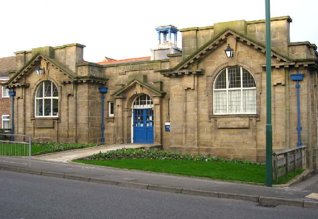
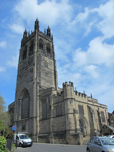
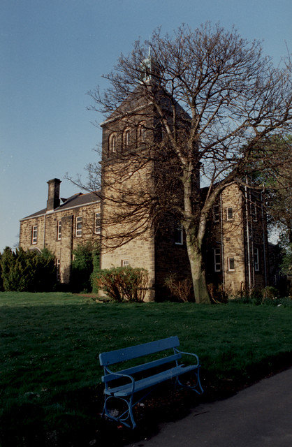
St. Nicholas Hospital
- St. Nicholas Hospital is located on Jubilee Road in the Coxlodge area of Gosforth. This psychiatric hospital was built 1865-1869, designed by WL Moffatt of Edinburgh for the County Borough of …
Co-Curate Page
Brandling Village
- Summary Map Brandling Village is part of Jesmond, a suburb of Newcastle. Parts of Brandling Village were a designated conservation area which includes 36 grade II listed buildings and St. …

Co-Curate Page
Whitburn
- Overview About Whitburn Map Street View Whitburn is a village on the coast of South Tyneside, located between South Shields and the City of Sunderland. Whitburn is a village in …
Co-Curate Page
Alnwick
- Overview History Map Street View Alnwick is a historic market town in Northumberland, located on the banks of the River Aln, 32 miles south of Berwick-upon-Tweed 34 miles north of …
Co-Curate Page
Easington
- Overview About Easington Map Street View Easington is a town in eastern County Durham, England. It comprises the ancient village of Easington Village and the ex-mining town of Easington …
Co-Curate Page
Kirkleatham
- Overview About Kirkleatham Map Street View Near Redcar Kirkleatham is a village in the unitary authority of Redcar and Cleveland and the ceremonial county of North Yorkshire, England. It is …
Co-Curate Page
Acklam
- Overview About Acklam Map Street View Acklam is a suburb of Middlesbrough, located to the east of Linthorpe. Before the growth of Middlesbrough, Acklam was small rural village. Earlier buildings …
Co-Curate Page
Staindrop
- Overview About Staindrop Map Street View Staindrop is a village and civil parish east of Barnard Castle in County Durham, England. The population (including Cleatlam and Killerby) at the …
Co-Curate Page
Westoe
- Overview Further Information Westoe is a suburb of South Shields. It was originally a separate village but was gradually absorbed into South Shields as the town expanded during the late …
Co-Curate Page
Nunthorpe
- Overview History Nunthorpe is an area on outer suburbs of Middlesbrough, which was previously a separate village. It was referred to as Thorp in the Domesday book of 1086. Its …
Co-Curate Page
Seaton Carew
- Overview About Seaton Carew Map Street View Seaton Carew is a small seaside resort in County Durham, North East England, with a population of 6,018 (2001). It is situated …
Co-Curate Page
Tudhoe
- Overview About Tudhoe Map Street View Tudhoe is a village in County Durham which is adjacent to Spennymoor. Tudhoe is a village in County Durham, in England. It is situated …
Co-Curate Page
Haltwhistle
- Overview About Haltwhistle Map Street View Haltwhistle is a small town and civil parish in Northumberland, England, 10 miles east of Brampton, near Hadrian's Wall. It had a population …
Co-Curate Page
Guyzance
- Overview About Guyzance Map Street View Guyzance is a village in Northumberland, located by the River Coquet and about 5 miles south of Alnwick and 3 miles west of Warkworth. …
Co-Curate Page
Ashbrooke
- Overview About Ashbrooke Map Street View Backhouse Park, Mowbray Park, Charlton House, Langham Tower, Ashbrooke House, Bede Tower, St. John's Methodist Church, Christ Church, West Hendon House Ashbrooke is a residential area …
Co-Curate Page
Windlestone
- Overview Map Street View Windlestone is located about 3½miles east of Bishop Auckland and 1 mile west of Chilton, in County Durham. In Medieval times, Windlestone was a manor and …
Co-Curate Page
Wolsingham
- Overview History Map Street View Wolsingham sits at the confluence of the River Wear and Waskerley Beck. It is a small settlement and one of the first market towns …
Co-Curate Page
Barningham
- Overview About Barningham Map Street View Barningham is a village in County Durham, in the Pennines, located about 2 miles south of Greta Bridge and 4 miles south-west of Barnard …
Co-Curate Page
Greta Bridge
- Overview About Greta Bridge Map Street View Greta Bridge is a village in the south of County Durham, located about 3 miles south-east of Barnard Castle. The village has been …
Co-Curate Page
Shotley Bridge
- Overview About Shotley Bridge Map Street Shotley Bridge is a village in the Derwent Valley, adjoining the town of Consett in County Durham, England. Shotley Bridge was once the …
Co-Curate Page
Ingleton
- Overview About Ingleton Map Street View Ingleton (County Durham) is a village located about 8 miles west of Darlington. Not to be confused with Ingleton in North Yorkshire. Ingleton is a …
Co-Curate Page
Bishop Middleham
- Overview History Map Street View Bishop Middleham is a village near Sedgefield in County Durham. Bishop Middleham is thought to have Anglo-Saxon origins. There are earthwork ruins of Bishop Middleham Castle …
Co-Curate Page
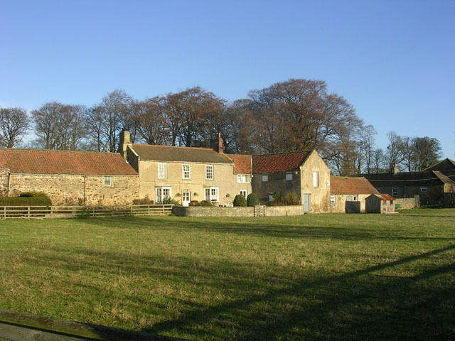
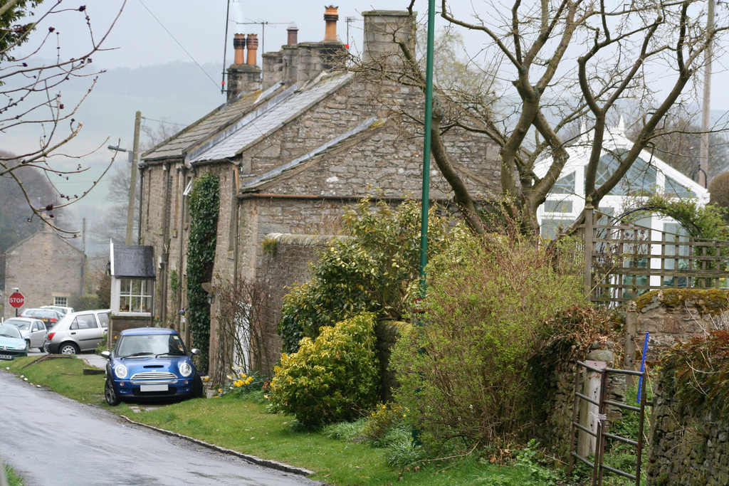
Lintzford
- Overview About Lintzford Map Street View Lintzford is a village on the banks of the River Derwent in the north of County Durham, near Rowlands Gill in Tyneside. Lintzford is a small …
Co-Curate Page
Trimdon
- "Trimdon has been the site of an established settlement since at least the 12th century and there has been documented evidence of archaeological discoveries dating from the Bronze Age onwards. …
Co-Curate Page
Gainford
- Overview About Gainford History Map Street View Gainford is a village in County Durham located by the River Tees and about 6 miles West of Darlington and a similar distance East …
Co-Curate Page
Cotherstone
- Overview About Cotherstone Map Street View Cotherstone is a village in County Durham which is situated near the confluence of the River Balder and the River Tees. Cotherstone is located …
Co-Curate Page
Eggleston
- Overview About Eggleston Map Street View Eggleston is a village in County Durham, in England. The population of the civil parish taken at the 2011 Census was 448. It …
Co-Curate Page
Annfield Plain
- Overview About Annfield Plain Map Annfield Plain is a village in County Durham, located between Stanley and Consett. The village's past is strongly associated with coal mining, which can be …
Co-Curate Page
Romaldkirk
- Overview About Romaldkirk Map Street View Romaldkirk is a village in Teesdale, County Durham, in the Pennines of England. The village lies within the historic boundaries of the North …
Co-Curate Page
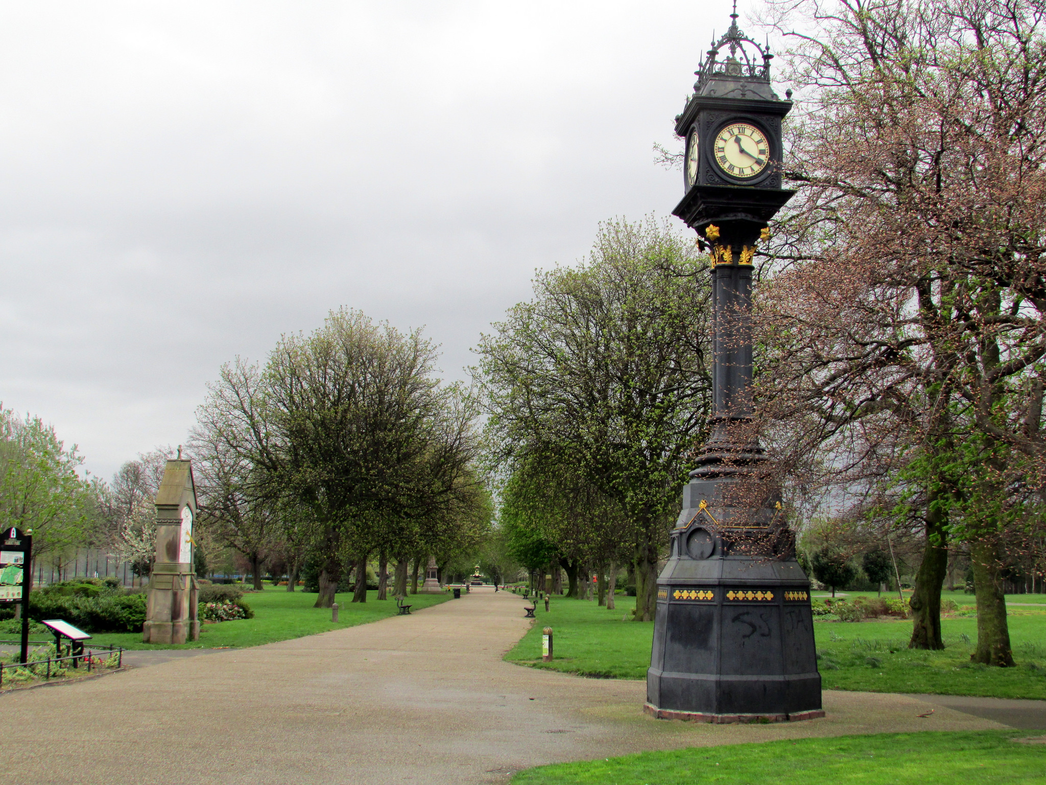
Albert Park
- Summary About Albert Park Map "A public park designed by William Barratt of Wakefield and opened 11th August 1868, with war memorial entrance screen walls and a cenotaph of 1922...The idea …
Co-Curate Page
Killingworth Village
- Overview About Map Street View Killingworth Village is located in the south east part of today's Killingworth. The old village and surrounding area was an important industrial area during the …
Co-Curate Page
Coatham Mundeville
- Overview Map Street View Coatham Mundeville is a village in the Borough of Darlington in County Durham. It is situated by the River Skerne near Brafferton, on the A167 between …
Co-Curate Page
Wackerfield
- Overview Map Street View Wackerfield is a hamlet in County Durham, which is located about 2 miles north-east of Staindrop and 2½ miles south-west of West Auckland. By the junction of the …
Co-Curate Page
Grainger Town
- Overview About Grainger Town Grainger Town is the historic heart of Newcastle, which incorporates streets built in a neo-classical style by Richard Grainger between 1824 and 1841, including the Grainger …

Co-Curate Page
Marton-in-Cleveland
- Overview About Marton Map Street View Marton-in-Cleveland is a suburb of Middlesbrough, previously a separate village, the older parts being a conservation area. St Cuthbert's Church in Marton is thought …

from https://www.newcastle.gov.uk/…
Conservation Profiles
- Profiles of Conservation areas in Newcastle. January 2011
Added by
Simon Cotterill
Co-Curate Page
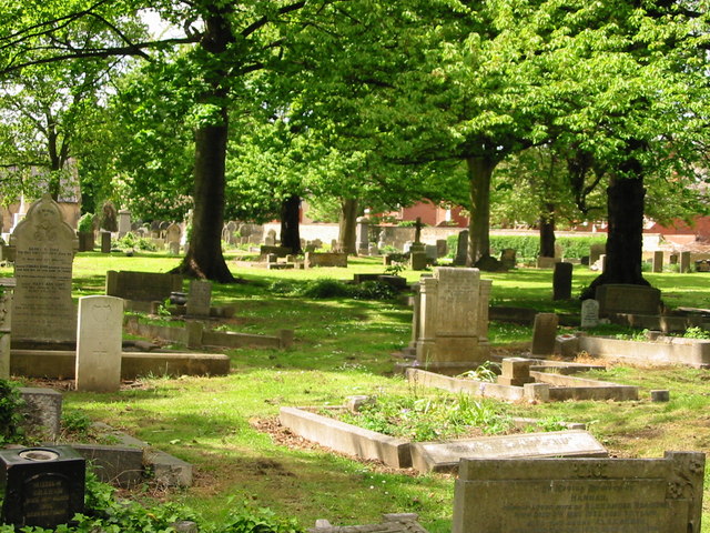
Roker Park Conservation Area
- Note: Map data from Sunderland City Council c/o Open Data UK, under the Open Government Licence, imported into Google MyMaps, February 2026. Check with SCC for amendments and updates.
Co-Curate Page
Summerhill
- Overview Map Street View Summerhill is a late Georgian residential suburb, which climbs the hill westwards out of Newcastle upon Tyne, between the city centre and the West End. The …

Co-Curate Page
Ashbrooke Conservation Area
- Ashbrooke Conservation Area was designated in 1969, and is the largest conservation area in Sunderland, covering almost 75 hectares. Ashbrooke is a spacious, leafy suburb with Victorian terraced housing, fine …
Co-Curate Page
Sherburn House
- Overview About Sherburn House Map Street View Sherburn House is a hamlet in County Durham, England. It is situated approximately 2 miles (3 km) south-east of Durham between Sherburn and …
Co-Curate Page
The Green, Wallsend
- Overview Map Street View The Green is a suburban area located to the north of Wallsend town centre. It was designated as a Conservation Area on 1st November, 1974. The …
Co-Curate Page
Annfield Plain Conservation Area
- "The special character of Annfield Plain Conservation Area is derived from its rapid growth in Victorian times as a town associated with the mining industry and the associated railway development. …
Co-Curate Page
Durham City Conservation Area
- "Durham City was designated as a conservation area on the 9th August 1968. This original designation included the peninsula with Durham Castle and cathedral, the Market Place and the Medieval …
Co-Curate Page
Bowes Conservation Area
- Map showing Bowes Conservation Area. Bowes Conservation Area was designated in 1984. The conservation area covers most of the village of Bowes in County Durham.
Co-Curate Page
Pittington Hallgarth Conservation Area
- Pittington Hallgarth lies 3.5 miles NE of Durham at the foot of the magnesian limestone escarpment. It is located on a low but pronounced spur overlooking a vale between Pittington, …
Co-Curate Page
Headlam Conservation Area
- Map showing Headlam Conservation Area. Headlam Conservation Area was designated in 1984. The conservation area covers nearly all of the village of Headlam, near Gainford, in County Durham.
Co-Curate Page
Cleatlam Conservation Area
- Cleatlam Conservation Area was designated in 1987. The conservation area covers nearly all of the village of Cleatlam in County Durham. Note: Map data from Durham County Council c/o Open …
Co-Curate Page
Little Newsham Conservation Area
- Little Newsham Conservation Area was designated in 1987. The conservation area covers the village of Little Newsham in County Durham. Note: Map data from Durham County Council c/o Open Data UK, …
Co-Curate Page
Whorlton Conservation Area
- Whorlton Conservation Area was designated in 1972. The conservation area covers almost the whole of the village of Whorlton in County Durham. Note: Map data from Durham County Council c/o …
Co-Curate Page
Greta Bridge Conservation Area
- Greta Bridge Conservation Area was designated in 1987. The conservation area covers the village of Greta Bridge in County Durham. Note: Map data from Durham County Council c/o Open Data …
Co-Curate Page
Barningham Conservation Area
- Barningham Conservation Area covers the village of Barningham in County Durham. The conservation area was designated on the 22nd April, 1984. Note: Map data from Durham County Council c/o Open …
Co-Curate Page
Barnard Castle Conservation Area
- Barnard Castle Conservation Area was designated in 1969. The conservation area covers a large part of the town of Barnard Castle in County Durham. Note: Map data from Durham County …
Co-Curate Page
Bolam Conservation Area
- Bolam Conservation Area was designated on the 10th March, 2010. The conservation area covers the village of Bolam in County Durham. Note: Map data from Durham County Council c/o Open …
Co-Curate Page
Kirk Merrington Conservation Area
- Kirk Merrington Conservation Area was designated in 1993. The conservation area covers parts of the village of Kirk Merringtonin County Durham. Note: Map data from Durham County Council c/o Open …
Co-Curate Page
Windlestone Conservation Area
- Windlestone Conservation Area was designated in 1993. The conservation area is centred on Windlestone Hall in County Durham. Note: Map data from Durham County Council c/o Open Data UK, under …
Co-Curate Page
Middridge Conservation Area
- Middridge Conservation Area was designated in 1993. The conservation area covers much of the village of Middridge, north-west of Newton Aycliffe, in County Durham. Note: Map data from Durham County …
Co-Curate Page
Aycliffe Village Conservation Area
- Aycliffe Village Conservation Area was designated in 1981 The conservation area includes a substantial proportion of Aycliffe Village, to the south of Newton Aycliff, in County Durham. Note: Map data …
Co-Curate Page
Cornforth Conservation Area
- Cornforth Conservation Area was designated in 1993. The conservation area includes part of Conforth in County Durham, covering the area around the Village Green and Holy Trinity Church. Note: Map …
Co-Curate Page
Mainsforth Conservation Area
- Mainsforth Conservation Area was designated in 1993. The conservation area covers much of the village of Mainsforth in County Durham. Note: Map data from Durham County Council c/o Open Data …
Co-Curate Page
Hardwick Park Conservation Area
- Hardwick Park Conservation Area was designated in 1993. The conservation area covers Hardwick Park, wich is directly west of Sedgefield, in County Durham. Note: Map data from Durham County Council …
Co-Curate Page
Easington Village Conservation Area
- Easington Village Conservation Area was designated in 1974. The conservation area covers much of the village of Easington in County Durham, including the area surrounding the village green. Note: Map …
Co-Curate Page
Seaham Conservation Area
- Seaham Conservation Area was designated in 1997. The conservation area covers part of the town of Seaham in County Durham, including the area around Tempest Road, Castlereagh Road, and the …
Co-Curate Page
Castle Eden Conservation Area
- Castle Eden Conservation Area was designated in 1976. The conservation area includes the village of Castle Eden and it's surounding area, in County Durham. Note: Map data from Durham County …
Co-Curate Page
Hunstanworth Conservation Area
- Hunstanworth Conservation Area was designated in 1993. The conservation area covers the village of Hunstanworth in County Durham. Note: Map data from Durham County Council c/o Open Data UK, under …
Co-Curate Page
Esh Conservation Area
- Esh Conservation Area was designated in 1975. The conservation area covers much of the village of Esh in County Durham, including the historic village centre, focusing on the area around …
Co-Curate Page
Ebchester Conservation Area
- Ebchester Conservation Area conservation area was designated in 1972 and it's boundaries extended in 1994. The conservation area preserves the historic core the village of Ebchester in County Durham, which …
Co-Curate Page
Tynemouth Village Conservation Area
- The conservation area was designated in 1971, with some boundary amendments made in 2009. A community-led Character Statement was adopted in July 2003. The Tynemouth Village Conservation Area Management Strategy …
Co-Curate Page
Burnopfield Conservation Area
- Note: Map data from Durham County Council c/o Open Data UK, under the Open Government Licence, imported into Google MyMaps, February 2026. Check with DCC for amendments and updates.
Co-Curate Page
Allonby Conservation Area
- Allonby Conservation Area was designated in 1975. The conservation area aims to protect the historic, architectural, and seaside character of the village of Allonby in Cumbria. The village is characterised …
Co-Curate Page
Ireshopeburn, Newhouse and West Blackdene Conservation Area
- Note: Map data from Durham County Council c/o Open Data UK, under the Open Government Licence, imported into Google MyMaps, February 2026. Check with DCC for amendments and updates.
Co-Curate Page
Newbiggin Conservation Area, County Durham
- Map data from Durham County Council c/o Open Data UK, under the Open Government Licence, imported into Google MyMaps, February 2026. Check with DCC for amendments and updates.
Co-Curate Page
Eggleston Conservation Area
- Note: Map data from Durham County Council c/o Open Data UK, under the Open Government Licence, imported into Google MyMaps, February 2026. Check with DCC for amendments and updates.
Co-Curate Page
Shildon Conservation Area
- Note: Map data from Durham County Council c/o Open Data UK, under the Open Government Licence, imported into Google MyMaps, February 2026. Check with DCC for amendments and updates.
Co-Curate Page
Tudhoe Conservation Area
- Note: Map data from Durham County Council c/o Open Data UK, under the Open Government Licence, imported into Google MyMaps, February 2026. Check with DCC for amendments and updates.
Co-Curate Page
Plawsworth Conservation Area
- Note: Map data from Durham County Council c/o Open Data UK, under the Open Government Licence, imported into Google MyMaps, February 2026. Check with DCC for amendments and updates.
Co-Curate Page
Chester-le-Street Conservation Area
- Note: Map data from Durham County Council c/o Open Data UK, under the Open Government Licence, imported into Google MyMaps, February 2026. Check with DCC for amendments and updates.
Co-Curate Page
Muggleswick Conservation Area
- Note: Map data from Durham County Council c/o Open Data UK, under the Open Government Licence, imported into Google MyMaps, February 2026. Check with DCC for amendments and updates.
Co-Curate Page
Edmondbyers Conservation Area
- Note: Map data from Durham County Council c/o Open Data UK, under the Open Government Licence, imported into Google MyMaps, February 2026. Check with DCC for amendments and updates.
Co-Curate Page
Bishop Middleham Conservation Area
- Bishop Middleham Conservation Area was designated in 1981 by the former Sedgefield Borough Council. Note: Map data from Durham County Council c/o Open Data UK, under the Open Government Licence, …
Co-Curate Page
Lartington Conservation Area
- Note: Map data from Durham County Council c/o Open Data UK, under the Open Government Licence, imported into Google MyMaps, February 2026. Check with DCC for amendments and updates.
Co-Curate Page
Mickleton Conservation Area
- Note: Map data from Durham County Council c/o Open Data UK, under the Open Government Licence, imported into Google MyMaps, February 2026. Check with DCC for amendments and updates.
Co-Curate Page
Staindrop Conservation Area
- Note: Map data from Durham County Council c/o Open Data UK, under the Open Government Licence, imported into Google MyMaps, February 2026. Check with DCC for amendments and updates.
Co-Curate Page
Trimdon Village Conservation Area
- Note: Map data from Durham County Council c/o Open Data UK, under the Open Government Licence, imported into Google MyMaps, February 2026. Check with DCC for amendments and updates.
Co-Curate Page
Beamish Burn Conservation Area
- Note: Map data from Durham County Council c/o Open Data UK, under the Open Government Licence, imported into Google MyMaps, February 2026. Check with DCC for amendments and updates.
Co-Curate Page
Langton Conservation Area
- Note: Map data from Durham County Council c/o Open Data UK, under the Open Government Licence, imported into Google MyMaps, February 2026. Check with DCC for amendments and updates.
Co-Curate Page
West Auckland Conservation Area
- Note: Map data from Durham County Council c/o Open Data UK, under the Open Government Licence, imported into Google MyMaps, February 2026. Check with DCC for amendments and updates.
Co-Curate Page
Bishop Auckland Conservation Area
- Note: Map data from Durham County Council c/o Open Data UK, under the Open Government Licence, imported into Google MyMaps, February 2026. Check with DCC for amendments and updates.
Co-Curate Page
Gainford Conservation Area
- Note: Map data from Durham County Council c/o Open Data UK, under the Open Government Licence, imported into Google MyMaps, February 2026. Check with DCC for amendments and updates.
Co-Curate Page
Lanchester Conservation Area
- Note: Map data from Durham County Council c/o Open Data UK, under the Open Government Licence, imported into Google MyMaps, February 2026. Check with DCC for amendments and updates.
Co-Curate Page
Sedgefield Conservation Area
- Note: Map data from Durham County Council c/o Open Data UK, under the Open Government Licence, imported into Google MyMaps, February 2026. Check with DCC for amendments and updates.
Co-Curate Page
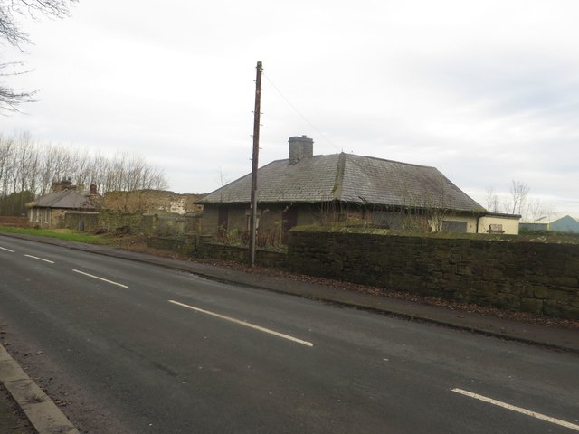
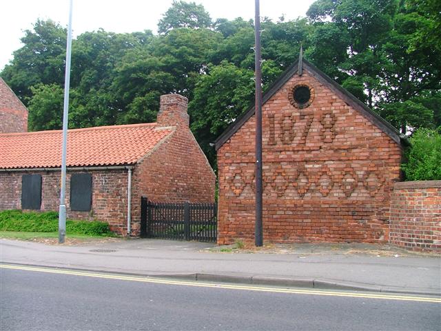
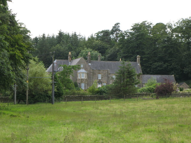
Lintzford Conservation Area
- Note: Map data from Gateshead Council c/o Open Data UK, under the Open Government Licence, imported into Google MyMaps, February 2026. Check with Gateshead Council for amendments and updates. The …
Co-Curate Page
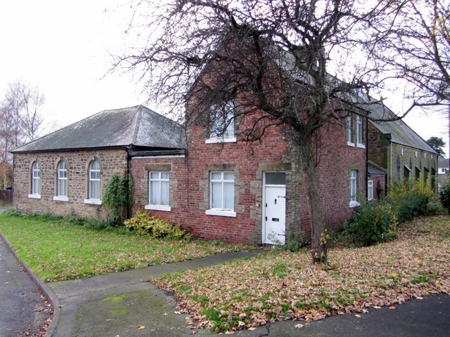
St Nicholas Hospital Conservation Area
- St Nicholas Hospital Conservation Area in the Coxlodge / Gosforth area of Newcastle, is a 19th-century mental healthcare site known for its Victorian stone architecture, mature parkland, pastoral and secluded …
Co-Curate Page
Framlington Place Conservation Area, Newcastle
- Map data from Newcastle City Council c/o Open Data UK, under the Open Government Licence, imported into Google MyMaps, February 2026. Check with NCC for amendments and updates. The Framlington …
Co-Curate Page
South Jesmond Conservation Area
- Note: Map data from Newcastle City Council c/o Open Data UK, under the Open Government Licence, imported into Google MyMaps, February 2026. Check with NCC for amendments and updates.
Co-Curate Page
Summerhill Square Conservation Area, Newcastle
- % Note: Map data from Newcastle City Council c/o Open Data UK, under the Open Government Licence, imported into Google MyMaps, February 2026. Check with NCC for amendments and updates.
Co-Curate Page
Northumberland Gardens Conservation Area, Newcastle
- % Note: Map data from Newcastle City Council c/o Open Data UK, under the Open Government Licence, imported into Google MyMaps, February 2026. Check with NCC for amendments and updates.
Co-Curate Page
Leazes Conservation Area, Newcastle
- % Note: Map data from Newcastle City Council c/o Open Data UK, under the Open Government Licence, imported into Google MyMaps, February 2026. Check with NCC for amendments and updates.
Co-Curate Page
Ouseburn Conservation Area
- Note: Map data from Newcastle City Council c/o Open Data UK, under the Open Government Licence, imported into Google MyMaps, February 2026. Check with NCC for amendments and updates.
Co-Curate Page
Jesmond Dene Conservation Area
- Note: Map data from Newcastle City Council c/o Open Data UK, under the Open Government Licence, imported into Google MyMaps, February 2026. Check with NCC for amendments and updates.
Co-Curate Page
Gosforth Conservation Area
- Note: Map data from Newcastle City Council c/o Open Data UK, under the Open Government Licence, imported into Google MyMaps, February 2026. Check with NCC for amendments and updates.
Co-Curate Page
Walbottle Conservation Area
- Note: Map data from Newcastle City Council c/o Open Data UK, under the Open Government Licence, imported into Google MyMaps, February 2026. Check with NCC for amendments and updates.
Co-Curate Page
Newcastle Central Conservation Area
- Note: Map data from Newcastle City Council c/o Open Data UK, under the Open Government Licence, imported into Google MyMaps, February 2026. Check with NCC for amendments and updates.
Co-Curate Page
Brandling Village Conservation Area
- Note: Map data from Newcastle City Council c/o Open Data UK, under the Open Government Licence, imported into Google MyMaps, February 2026. Check with NCC for amendments and updates.
Co-Curate Page
Longbenton Conservation Area
- Note: Map data from North Tyneside Council c/o Open Data UK, under the Open Government Licence, imported into Google MyMaps, February 2026. Check with NTC for amendments and updates.
Co-Curate Page
Killingworth Conservation Area
- Note: Map data from North Tyneside Council c/o Open Data UK, under the Open Government Licence, imported into Google MyMaps, February 2026. Check with NTC for amendments and updates.
Co-Curate Page
Sacred Heart Wideopen Conservation Area
- Note: Map data from North Tyneside Council c/o Open Data UK, under the Open Government Licence, imported into Google MyMaps, February 2026. Check with NTC for amendments and updates.
Co-Curate Page
Backworth Conservation Area
- Note: Map data from North Tyneside Council c/o Open Data UK, under the Open Government Licence, imported into Google MyMaps, February 2026. Check with NTC for amendments and updates.
Co-Curate Page
Earsdon Conservation Area
- Note: Map data from North Tyneside Council c/o Open Data UK, under the Open Government Licence, imported into Google MyMaps, February 2026. Check with NTC for amendments and updates.
Co-Curate Page
St Mary's Island Conservation Area
- The conservation area incorporates not only St Mary's Island, but also the surrounding rocky landscape and the mainland area around it, including a nature reserve and 2 Sites of Special …
Co-Curate Page
Monkseaton Conservation Area
- Note: Map data from North Tyneside Council c/o Open Data UK, under the Open Government Licence, imported into Google MyMaps, February 2026. Check with NTC for amendments and updates.
Co-Curate Page
Cullercoats Conservation Area
- Note: Map data from North Tyneside Council c/o Open Data UK, under the Open Government Licence, imported into Google MyMaps, February 2026. Check with NTC for amendments and updates.
Co-Curate Page
Preston Park Conservation Area
- Note: Map data from North Tyneside Council c/o Open Data UK, under the Open Government Licence, imported into Google MyMaps, February 2026. Check with NTC for amendments and updates.
Co-Curate Page
Camp Terrace Conservation Area, Norh Shields
- Map data from North Tyneside Council c/o Open Data UK, under the Open Government Licence, imported into Google MyMaps, February 2026. Check with NTC for amendments and updates. The Camp …
Co-Curate Page
Northumberland Square Conservation Area, North Shields
- % Note: Map data from North Tyneside Council c/o Open Data UK, under the Open Government Licence, imported into Google MyMaps, February 2026. Check with NTC for amendments and updates.
Co-Curate Page
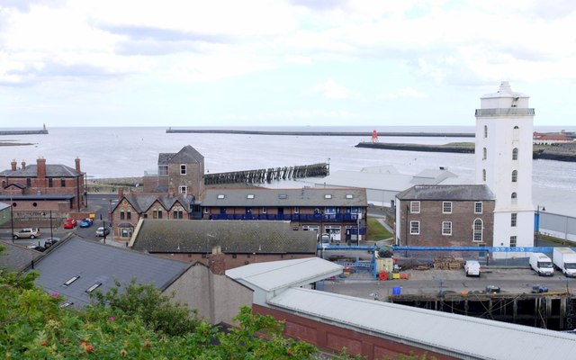
Fish Quay Conservation Area, North Shields
- % Note: Map data from North Tyneside Council c/o Open Data UK, under the Open Government Licence, imported into Google MyMaps, February 2026. Check with NTC for amendments and updates.
Co-Curate Page
St Peters Conservation Area, Wallsend
- % Note: Map data from North Tyneside Council c/o Open Data UK, under the Open Government Licence, imported into Google MyMaps, February 2026. Check with NTC for amendments and updates.
Co-Curate Page
Wallsend Green Conservation Area
- Note: Map data from North Tyneside Council c/o Open Data UK, under the Open Government Licence, imported into Google MyMaps, February 2026. Check with NTC for amendments and updates.
Co-Curate Page
Coatsworth Conservation Area
- Note: Map data from Gateshead Council c/o Open Data UK, under the Open Government Licence, imported into Google MyMaps, February 2026. Check with Gateshead Council for amendments and updates.
Co-Curate Page
Saltwell Conservation Area
- Note: Map data from Gateshead Council c/o Open Data UK, under the Open Government Licence, imported into Google MyMaps, February 2026. Check with Gateshead Council for amendments and updates.
Co-Curate Page
Chowdene Conservation Area
- Note: Map data from Gateshead Council c/o Open Data UK, under the Open Government Licence, imported into Google MyMaps, February 2026. Check with Gateshead Council for amendments and updates.
Co-Curate Page
Ryton Conservation Area
- Note: Map data from Gateshead Council c/o Open Data UK, under the Open Government Licence, imported into Google MyMaps, February 2026. Check with Gateshead Council for amendments and updates.
Co-Curate Page
Ravensworth Conservation Area
- Note: Map data from Gateshead Council c/o Open Data UK, under the Open Government Licence, imported into Google MyMaps, February 2026. Check with Gateshead Council for amendments and updates.
Co-Curate Page
Birtley Conservation Area, Gateshead
- Note: Map data from Gateshead Council c/o Open Data UK, under the Open Government Licence, imported into Google MyMaps, February 2026. Check with Gateshead Council for amendments and updates.
Co-Curate Page
Clara Vale Conservation Area
- Note: Map data from Gateshead Council c/o Open Data UK, under the Open Government Licence, imported into Google MyMaps, February 2026. Check with Gateshead Council for amendments and updates.
Co-Curate Page
Bradley Park Conservation Area, Gateshead
- Note: Map data from Gateshead Council c/o Open Data UK, under the Open Government Licence, imported into Google MyMaps, February 2026. Check with Gateshead Council for amendments and updates.
Co-Curate Page
Path Head Conservation Area
- Note: Map data from Gateshead Council c/o Open Data UK, under the Open Government Licence, imported into Google MyMaps, February 2026. Check with Gateshead Council for amendments and updates.
Co-Curate Page
Blaydon Conservation Area
- Note: Map data from Gateshead Council c/o Open Data UK, under the Open Government Licence, imported into Google MyMaps, February 2026. Check with Gateshead Council for amendments and updates.
Co-Curate Page
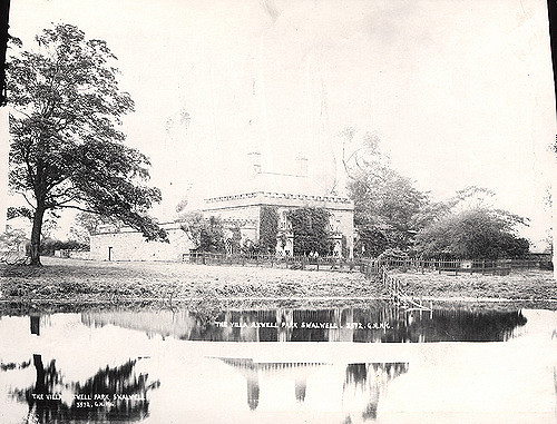
Axwell Park Conservation Area
- Note: Map data from Gateshead Council c/o Open Data UK, under the Open Government Licence, imported into Google MyMaps, February 2026. Check with Gateshead Council for amendments and updates.
Co-Curate Page
Gibside Conservation Area
- Note: Map data from Gateshead Council c/o Open Data UK, under the Open Government Licence, imported into Google MyMaps, February 2026. Check with Gateshead Council for amendments and updates.
Co-Curate Page
Marley Hill Conservation Area
- Note: Map data from Gateshead Council c/o Open Data UK, under the Open Government Licence, imported into Google MyMaps, February 2026. Check with Gateshead Council for amendments and updates.
Co-Curate Page
Whickham Conservation Area
- Note: Map data from Gateshead Council c/o Open Data UK, under the Open Government Licence, imported into Google MyMaps, February 2026. Check with Gateshead Council for amendments and updates.
Co-Curate Page
Sheriff Hall Conservation Area
- Note: Map data from Gateshead Council c/o Open Data UK, under the Open Government Licence, imported into Google MyMaps, February 2026. Check with Gateshead Council for amendments and updates.
Co-Curate Page
Rowlands Gill Conservation Area
- Note: Map data from Gateshead Council c/o Open Data UK, under the Open Government Licence, imported into Google MyMaps, February 2026. Check with Gateshead Council for amendments and updates.
Co-Curate Page
Crow Hall Conservation Area, Gateshead
- Note: Map data from Gateshead Council c/o Open Data UK, under the Open Government Licence, imported into Google MyMaps, February 2026. Check with Gateshead Council for amendments and updates.
Co-Curate Page
Low Fell Conservation Area
- Note: Map data from Gateshead Council c/o Open Data UK, under the Open Government Licence, imported into Google MyMaps, February 2026. Check with Gateshead Council for amendments and updates.
Co-Curate Page
Bridges Conservation Area, Gateshead
- Note: Map data from Gateshead Council c/o Open Data UK, under the Open Government Licence, imported into Google MyMaps, February 2026. Check with Gateshead Council for amendments and updates.
Co-Curate Page
Walker Terrace/Regent Street Conservation Area, Gateshead
- Note: Map data from Gateshead Council c/o Open Data UK, under the Open Government Licence, imported into Google MyMaps, February 2026. Check with Gateshead Council for amendments and updates.
Co-Curate Page
Hebburn Hall Conservation Area
- Note: Map data from South Tyneside Council c/o Open Data UK, under the Open Government Licence, imported into Google MyMaps, February 2026. Check with STC for amendments and updates.
Co-Curate Page
Cleadon Hills Conservation Area
- Note: Map data from South Tyneside Council c/o Open Data UK, under the Open Government Licence, imported into Google MyMaps, February 2026. Check with STC for amendments and updates.
Co-Curate Page
Whitburn Conservation Areas
- % Note: Map data from South Tyneside Council c/o Open Data UK, under the Open Government Licence, imported into Google MyMaps, February 2026. Check with STC for amendments and updates.
Co-Curate Page
Cleadon Conservation Area
- Note: Map data from South Tyneside Council c/o Open Data UK, under the Open Government Licence, imported into Google MyMaps, February 2026. Check with STC for amendments and updates.
Co-Curate Page
East Boldon Conservation Area
- Note: Map data from South Tyneside Council c/o Open Data UK, under the Open Government Licence, imported into Google MyMaps, February 2026. Check with STC for amendments and updates.
Co-Curate Page
Mariners' Cottages Conservation Area
- Note: Map data from South Tyneside Council c/o Open Data UK, under the Open Government Licence, imported into Google MyMaps, February 2026. Check with STC for amendments and updates.
Co-Curate Page
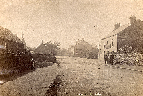
Monkton Conservation Area
- Note: Map data from South Tyneside Council c/o Open Data UK, under the Open Government Licence, imported into Google MyMaps, February 2026. Check with STC for amendments and updates.
Co-Curate Page
St Paul's Conservation Area, Jarrow
- % Note: Map data from South Tyneside Council c/o Open Data UK, under the Open Government Licence, imported into Google MyMaps, February 2026. Check with STC for amendments and updates.
Co-Curate Page
Westoe Conservation Area
- Note: Map data from South Tyneside Council c/o Open Data UK, under the Open Government Licence, imported into Google MyMaps, February 2026. Check with STC for amendments and updates.
Co-Curate Page
West Boldon Conservation Area
- Note: Map data from South Tyneside Council c/o Open Data UK, under the Open Government Licence, imported into Google MyMaps, February 2026. Check with STC for amendments and updates.
Co-Curate Page
Nesham Place Conservation Area
- Note: Map data from Sunderland City Council c/o Open Data UK, under the Open Government Licence, imported into Google MyMaps, February 2026. Check with SCC for amendments and updates.
Co-Curate Page
Newbottle Village Conservation Area
- Note: Map data from Sunderland City Council c/o Open Data UK, under the Open Government Licence, imported into Google MyMaps, February 2026. Check with SCC for amendments and updates.
Co-Curate Page
Old Sunderland Riverside Conservation Area
- Note: Map data from Sunderland City Council c/o Open Data UK, under the Open Government Licence, imported into Google MyMaps, February 2026. Check with SCC for amendments and updates.
Co-Curate Page
The Cedars Conservation Area, Sunderland
- % Note: Map data from Sunderland City Council c/o Open Data UK, under the Open Government Licence, imported into Google MyMaps, February 2026. Check with SCC for amendments and updates.
Co-Curate Page
Old Sunderland Conservation Area
- Note: Map data from Sunderland City Council c/o Open Data UK, under the Open Government Licence, imported into Google MyMaps, February 2026. Check with SCC for amendments and updates.
Co-Curate Page
Ryhope Village Conservation Area
- Note: Map data from Sunderland City Council c/o Open Data UK, under the Open Government Licence, imported into Google MyMaps, February 2026. Check with SCC for amendments and updates.
Co-Curate Page
St Michael's Conservation Area
- Note: Map data from Sunderland City Council c/o Open Data UK, under the Open Government Licence, imported into Google MyMaps, February 2026. Check with SCC for amendments and updates.
Co-Curate Page
Bishopwearmouth Conservation Area
- Note: Map data from Sunderland City Council c/o Open Data UK, under the Open Government Licence, imported into Google MyMaps, February 2026. Check with SCC for amendments and updates.
Co-Curate Page
Sunniside Conservation Area
- Note: Map data from Sunderland City Council c/o Open Data UK, under the Open Government Licence, imported into Google MyMaps, February 2026. Check with SCC for amendments and updates.
Co-Curate Page
Washington Village Conservation Area
- Note: Map data from Sunderland City Council c/o Open Data UK, under the Open Government Licence, imported into Google MyMaps, February 2026. Check with SCC for amendments and updates.
Co-Curate Page
Whitburn Bents Conservation Area
- Note: Map data from Sunderland City Council c/o Open Data UK, under the Open Government Licence, imported into Google MyMaps, February 2026. Check with SCC for amendments and updates.
Co-Curate Page
Silksworth Hall Conservation Area
- Note: Map data from Sunderland City Council c/o Open Data UK, under the Open Government Licence, imported into Google MyMaps, February 2026. Check with SCC for amendments and updates.
Co-Curate Page
Acklam Hall Conservation Area
- Note: Map data from Middlesbrough Council c/o Open Data UK, under the Open Government Licence, imported into Google MyMaps, February 2026. Check with Middlesbrough Council for amendments and updates.
Co-Curate Page
Albert Park and Linthorpe Road Conservation Area
- Note: Map data from Middlesbrough Council c/o Open Data UK, under the Open Government Licence, imported into Google MyMaps, February 2026. Check with Middlesbrough Council for amendments and updates.
Co-Curate Page
Linthorpe Conservation Area
- Note: Map data from Middlesbrough Council c/o Open Data UK, under the Open Government Licence, imported into Google MyMaps, February 2026. Check with Middlesbrough Council for amendments and updates.
Co-Curate Page
Marton Village and The Grove Conservation Area
- Note: Map data from Middlesbrough Council c/o Open Data UK, under the Open Government Licence, imported into Google MyMaps, February 2026. Check with Middlesbrough Council for amendments and updates.
Co-Curate Page
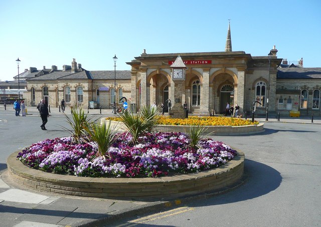
Middlesbrough Historic Quarter Conservation Area
- Middlesbrough Historic Quarter Conservation Area was designated in 1989 and covers the town’s Victorian commercial core, centred around Middlesbrough Station. The area retains it’s layout and architectural style from its …
Co-Curate Page
Nunthorpe and Poole Conservation Area
- Note: Map data from Middlesbrough Council c/o Open Data UK, under the Open Government Licence, imported into Google MyMaps, February 2026. Check with Middlesbrough Council for amendments and updates. This …
Co-Curate Page
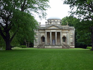
Ormesby Hall Conservation Area
- The Conservation Area covers both the historic settlement of Ormesby and the immediate landscape setting of Ormesby Hall, which is a National Trust property. Ormesby Hall Conservation Area was designated …
Co-Curate Page
Stainton and Thornton Conservation Area
- Note: Map data from Middlesbrough Council c/o Open Data UK, under the Open Government Licence, imported into Google MyMaps, February 2026. Check with Middlesbrough Council for amendments and updates.
Co-Curate Page
Bishopton Conservation Area
- Note: Map data from Darlington Council c/o Open Data UK, under the Open Government Licence, imported into Google MyMaps, February 2026. Check with Darlington Council for amendments and updates.
Co-Curate Page
Denton Conservation Area, Darlington
- Note: Map data from Darlington Council c/o Open Data UK, under the Open Government Licence, imported into Google MyMaps, February 2026. Check with Darlington Council for amendments and updates.
Co-Curate Page
High Coniscliffe Conservation Area
- Note: Map data from Darlington Council c/o Open Data UK, under the Open Government Licence, imported into Google MyMaps, February 2026. Check with Darlington Council for amendments and updates.
Co-Curate Page
Piercebridge Conservation Area
- Note: Map data from Darlington Council c/o Open Data UK, under the Open Government Licence, imported into Google MyMaps, February 2026. Check with Darlington Council for amendments and updates.
Co-Curate Page
Summerhouse Conservation Area, Darlington
- % Note: Map data from Darlington Council c/o Open Data UK, under the Open Government Licence, imported into Google MyMaps, February 2026. Check with Darlington Council for amendments and updates.
Co-Curate Page
Northgate Conservation Area
- Note: Map data from Darlington Council c/o Open Data UK, under the Open Government Licence, imported into Google MyMaps, February 2026. Check with Darlington Council for amendments and updates.
Co-Curate Page
Victoria Embankment Conservation Area
- Note: Map data from Darlington Council c/o Open Data UK, under the Open Government Licence, imported into Google MyMaps, February 2026. Check with Darlington Council for amendments and updates.
Co-Curate Page
Cockerton Village Conservation Area
- Note: Map data from Darlington Council c/o Open Data UK, under the Open Government Licence, imported into Google MyMaps, February 2026. Check with Darlington Council for amendments and updates.
Co-Curate Page
Middleton One Row Conservation Area
- Note: Map data from Darlington Council c/o Open Data UK, under the Open Government Licence, imported into Google MyMaps, February 2026. Check with Darlington Council for amendments and updates.
Co-Curate Page
Hurworth Conservation Area
- Note: Map data from Darlington Council c/o Open Data UK, under the Open Government Licence, imported into Google MyMaps, February 2026. Check with Darlington Council for amendments and updates.
Co-Curate Page
West End Conservation Area
- Note: Map data from Darlington Council c/o Open Data UK, under the Open Government Licence, imported into Google MyMaps, February 2026. Check with Darlington Council for amendments and updates.
Co-Curate Page
Darlington Town Centre Conservation Area
- Note: Map data from Darlington Council c/o Open Data UK, under the Open Government Licence, imported into Google MyMaps, February 2026. Check with Darlington Council for amendments and updates.
Co-Curate Page
Haughton-le-Skerne Conservation Area
- Note: Map data from Darlington Council c/o Open Data UK, under the Open Government Licence, imported into Google MyMaps, February 2026. Check with Darlington Council for amendments and updates.
Co-Curate Page
Parkgate Conservation Area
- Note: Map data from Darlington Council c/o Open Data UK, under the Open Government Licence, imported into Google MyMaps, February 2026. Check with Darlington Council for amendments and updates.
Co-Curate Page
Heighington Conservation Area
- Note: Map data from Darlington Council c/o Open Data UK, under the Open Government Licence, imported into Google MyMaps, February 2026. Check with Darlington Council for amendments and updates.
Co-Curate Page
Sadberge Conservation Area
- Note: Map data from Darlington Council c/o Open Data UK, under the Open Government Licence, imported into Google MyMaps, February 2026. Check with Darlington Council for amendments and updates.
Co-Curate Page
Elwick Conservation Area
- Note: Map data from Hartlepool Borough Council c/o Open Data UK, under the Open Government Licence, imported into Google MyMaps, February 2026. Check with HBC for amendments and updates.
Co-Curate Page
Greatham Conservation Area
- Note: Map data from Hartlepool Borough Council c/o Open Data UK, under the Open Government Licence, imported into Google MyMaps, February 2026. Check with HBC for amendments and updates.
Co-Curate Page
Seaton Carew Conservation Area
- Note: Map data from Hartlepool Borough Council c/o Open Data UK, under the Open Government Licence, imported into Google MyMaps, February 2026. Check with HBC for amendments and updates.
Co-Curate Page
Headland Conservation Area
- The Headland Conservation Area in Hartlepool includes the historic core of the town, featuring a mix of medieval to Victorian maritime architecture. The Headland (a coastal peninsula) was the site …
Co-Curate Page
Grange Conservation Area
- Note: Map data from Hartlepool Borough Council c/o Open Data UK, under the Open Government Licence, imported into Google MyMaps, February 2026. Check with HBC for amendments and updates.
Co-Curate Page
Park Conservation Area
- The Park Conservation Area in Hartlepool includes Ward Jackson Park and adjacent residential areas. It is characterized by its historic, low-density housing and green, open spaces. The conservation area was …
Co-Curate Page
Church Street Conservation Area
- Note: Map data from Hartlepool Borough Council c/o Open Data UK, under the Open Government Licence, imported into Google MyMaps, February 2026. Check with HBC for amendments and updates.
Co-Curate Page
Yarm Conservation Area
- Note: Map data from Stockton-on-Tees Borough Council c/o Open Data UK, under the Open Government Licence, imported into Google MyMaps, February 2026. Check with SBC for amendments and updates.
Co-Curate Page
Thornaby Green Conservation Area
- Note: Map data from Stockton-on-Tees Borough Council c/o Open Data UK, under the Open Government Licence, imported into Google MyMaps, February 2026. Check with SBC for amendments and updates.
Co-Curate Page
Hartburn Conservation Area
- Note: Map data from Stockton-on-Tees Borough Council c/o Open Data UK, under the Open Government Licence, imported into Google MyMaps, February 2026. Check with SBC for amendments and updates.
Co-Curate Page
Saltburn-by-the-Sea Conservation Area
- Note: Map data from Redcar and Cleveland Borough Council c/o Open Data UK, under the Open Government Licence, imported into Google MyMaps, February 2026. Check with RCBC for amendments and …
Co-Curate Page
Blyth Heritage Conservation Area
- Note: Map data from Northumberland County Council c/o Open Data UK, under the Open Government Licence, imported into Google MyMaps, February 2026. Check with NCC for amendments and updates.
Co-Curate Page
Blyth Central Conservation Area
- Note: Map data from Northumberland County Council c/o Open Data UK, under the Open Government Licence, imported into Google MyMaps, February 2026. Check with NCC for amendments and updates.
Co-Curate Page
Bondicar Terrace Conservation Area
- Note: Map data from Northumberland County Council c/o Open Data UK, under the Open Government Licence, imported into Google MyMaps, February 2026. Check with NCC for amendments and updates.
Co-Curate Page
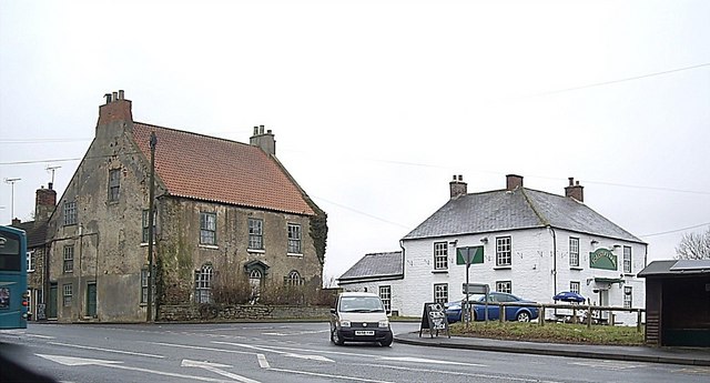
Bedlington Conservation Area
- Bedlington Conservation Area was designated in July, 1971 and the boundaries extended in 2011. The area is centred around Front Street and the Market Place in Bedlinton, preserving it’s historic, …
Co-Curate Page
Beckermet Conservation Area
- Note: Map data from Cumberland Council c/o Open Data UK, under the Open Government Licence, imported into Google MyMaps, February 2026. Check with Cumberland Council for amendments and updates.
Co-Curate Page
Appleby Conservation Area
- Note: Map data from Westmorland & Furness Council c/o Open Data UK, under the Open Government Licence, imported into Google MyMaps, February 2026. Check with W&FC for amendments and updates.
Co-Curate Page
Belford Conservation Area
- Note: Map data from Northumberland County Council c/o Open Data UK, under the Open Government Licence, imported into Google MyMaps, February 2026. Check with NCC for amendments and updates.
Co-Curate Page
Holy Island Conservation Area
- Note: Map data from Northumberland County Council c/o Open Data UK, under the Open Government Licence, imported into Google MyMaps, February 2026. Check with NCC for amendments and updates.
Co-Curate Page
Conservation Areas
- Summary County Durham Cumbria Northumberland Tees Valley Tyne and Wear Conservation areas have special restrictions imposed on development in order to retain the character of the area. Conservation areas were …
Co-Curate Page
Rothbury Conservation Area
- Note: Map data from Northumberland County Council c/o Open Data UK, under the Open Government Licence, imported into Google MyMaps, February 2026. Check with NCC for amendments and updates.
Co-Curate Page
Warkworth Conservation Area
- Note: Map data from Northumberland County Council c/o Open Data UK, under the Open Government Licence, imported into Google MyMaps, February 2026. Check with NCC for amendments and updates.
Co-Curate Page
Bothal Conservation Area
- Note: Map data from Northumberland County Council c/o Open Data UK, under the Open Government Licence, imported into Google MyMaps, February 2026. Check with NCC for amendments and updates.
Co-Curate Page
Holywell Conservation Area, Northumberland
- Map data from Northumberland County Council c/o Open Data UK, under the Open Government Licence, imported into Google MyMaps, February 2026. Check with NCC for amendments and updates
Co-Curate Page
Cramlington Village Conservation Area
- Note: Map data from Northumberland County Council c/o Open Data UK, under the Open Government Licence, imported into Google MyMaps, February 2026. Check with NCC for amendments and updates.
Co-Curate Page
Seaton Delaval Conservation Area
- Note: Map data from Northumberland County Council c/o Open Data UK, under the Open Government Licence, imported into Google MyMaps, February 2026. Check with NCC for amendments and updates.
Co-Curate Page
Bamburgh Conservation Area
- Note: Map data from Northumberland County Council c/o Open Data UK, under the Open Government Licence, imported into Google MyMaps, February 2026. Check with NCC for amendments and updates.
Co-Curate Page
Chatton Conservation Area
- Note: Map data from Northumberland County Council c/o Open Data UK, under the Open Government Licence, imported into Google MyMaps, February 2026. Check with NCC for amendments and updates.
Co-Curate Page
Kirknewton Conservation Area
- Note: Map data from Northumberland County Council c/o Open Data UK, under the Open Government Licence, imported into Google MyMaps, February 2026. Check with NCC for amendments and updates.
Co-Curate Page
Belsay Conservation Area
- Note: Map data from Northumberland County Council c/o Open Data UK, under the Open Government Licence, imported into Google MyMaps, February 2026. Check with NCC for amendments and updates.
Co-Curate Page
Cambo Conservation Area
- The Cambo Conservation Area represents a preserved example of a historic, estate-led village in Northumberland, retaining its architectural, social, and landscape value. The village of Cambo, largely remodelled in the …
Co-Curate Page
Middleton Conservation Area, Northumberland
- % Note: Map data from Northumberland County Council c/o Open Data UK, under the Open Government Licence, imported into Google MyMaps, February 2026. Check with NCC for amendments and updates.
Co-Curate Page
Capheaton Conservation Area
- Note: Map data from Northumberland County Council c/o Open Data UK, under the Open Government Licence, imported into Google MyMaps, February 2026. Check with NCC for amendments and updates.
Co-Curate Page
Longhirst Conservation Area
- Note: Map data from Northumberland County Council c/o Open Data UK, under the Open Government Licence, imported into Google MyMaps, February 2026. Check with NCC for amendments and updates.
Co-Curate Page
Longhorsley Conservation Area
- Note: Map data from Northumberland County Council c/o Open Data UK, under the Open Government Licence, imported into Google MyMaps, February 2026. Check with NCC for amendments and updates.
Co-Curate Page
Matfen Conservation Area
- Note: Map data from Northumberland County Council c/o Open Data UK, under the Open Government Licence, imported into Google MyMaps, February 2026. Check with NCC for amendments and updates.
Co-Curate Page
Whalton Conservation Area
- Note: Map data from Northumberland County Council c/o Open Data UK, under the Open Government Licence, imported into Google MyMaps, February 2026. Check with NCC for amendments and updates.
Co-Curate Page
West Thirston Conservation Area
- Note: Map data from Northumberland County Council c/o Open Data UK, under the Open Government Licence, imported into Google MyMaps, February 2026. Check with NCC for amendments and updates.
Co-Curate Page
Stamfordham Conservation Area
- Note: Map data from Northumberland County Council c/o Open Data UK, under the Open Government Licence, imported into Google MyMaps, February 2026. Check with NCC for amendments and updates.
Co-Curate Page
Netherwitton Conservation Area
- Note: Map data from Northumberland County Council c/o Open Data UK, under the Open Government Licence, imported into Google MyMaps, February 2026. Check with NCC for amendments and updates.
Co-Curate Page
High Callerton Conservation Area
- Note: Map data from Northumberland County Council c/o Open Data UK, under the Open Government Licence, imported into Google MyMaps, February 2026. Check with NCC for amendments and updates.
Co-Curate Page
Ponteland Conservation Area
- Note: Map data from Northumberland County Council c/o Open Data UK, under the Open Government Licence, imported into Google MyMaps, February 2026. Check with NCC for amendments and updates.
Co-Curate Page
North Sunderland Conservation Area
- Note: Map data from Northumberland County Council c/o Open Data UK, under the Open Government Licence, imported into Google MyMaps, February 2026. Check with NCC for amendments and updates.
Co-Curate Page
Alnwick Conservation Area
- Note: Map data from Northumberland County Council c/o Open Data UK, under the Open Government Licence, imported into Google MyMaps, February 2026. Check with NCC for amendments and updates.
Co-Curate Page
Alnmouth Conservation Area
- Note: Map data from Northumberland County Council c/o Open Data UK, under the Open Government Licence, imported into Google MyMaps, February 2026. Check with NCC for amendments and updates.
Co-Curate Page
Eglingham Conservation Area
- Note: Map data from Northumberland County Council c/o Open Data UK, under the Open Government Licence, imported into Google MyMaps, February 2026. Check with NCC for amendments and updates.
Co-Curate Page
Felton Conservation Area
- Note: Map data from Northumberland County Council c/o Open Data UK, under the Open Government Licence, imported into Google MyMaps, February 2026. Check with NCC for amendments and updates.
Co-Curate Page
Glanton Conservation Area
- Note: Map data from Northumberland County Council c/o Open Data UK, under the Open Government Licence, imported into Google MyMaps, February 2026. Check with NCC for amendments and updates.
Co-Curate Page
Lesbury Conservation Area
- Note: Map data from Northumberland County Council c/o Open Data UK, under the Open Government Licence, imported into Google MyMaps, February 2026. Check with NCC for amendments and updates.
Co-Curate Page
Newton on the Moor Conservation Area
- Note: Map data from Northumberland County Council c/o Open Data UK, under the Open Government Licence, imported into Google MyMaps, February 2026. Check with NCC for amendments and updates.
Co-Curate Page
Whittingham Conservation Area
- Note: Map data from Northumberland County Council c/o Open Data UK, under the Open Government Licence, imported into Google MyMaps, February 2026. Check with NCC for amendments and updates.
Co-Curate Page
Wooler Conservation Area
- Note: Map data from Northumberland County Council c/o Open Data UK, under the Open Government Licence, imported into Google MyMaps, February 2026. Check with NCC for amendments and updates.
Co-Curate Page
Rock Conservation Area, Northumberland
- % Note: Map data from Northumberland County Council c/o Open Data UK, under the Open Government Licence, imported into Google MyMaps, February 2026. Check with NCC for amendments and updates.
Co-Curate Page
Whitton Conservation Area
- Note: Map data from Northumberland County Council c/o Open Data UK, under the Open Government Licence, imported into Google MyMaps, February 2026. Check with NCC for amendments and updates.
Co-Curate Page
Embleton Conservation Area
- Note: Map data from Northumberland County Council c/o Open Data UK, under the Open Government Licence, imported into Google MyMaps, February 2026. Check with NCC for amendments and updates.
Co-Curate Page
Amble Conservation Area
- Note: Map data from Northumberland County Council c/o Open Data UK, under the Open Government Licence, imported into Google MyMaps, February 2026. Check with NCC for amendments and updates.
Co-Curate Page
Guyzance Conservation Area
- Note: Map data from Northumberland County Council c/o Open Data UK, under the Open Government Licence, imported into Google MyMaps, February 2026. Check with NCC for amendments and updates.
Co-Curate Page
Corbridge Conservation Area
- Note: Map data from Northumberland County Council c/o Open Data UK, under the Open Government Licence, imported into Google MyMaps, February 2026. Check with NCC for amendments and updates.
Co-Curate Page
Great Whittington Conservation Area
- Note: Map data from Northumberland County Council c/o Open Data UK, under the Open Government Licence, imported into Google MyMaps, February 2026. Check with NCC for amendments and updates.
Co-Curate Page
Wall Conservation Area, Northumberland
- % Note: Map data from Northumberland County Council c/o Open Data UK, under the Open Government Licence, imported into Google MyMaps, February 2026. Check with NCC for amendments and updates.
Co-Curate Page
Ovington Conservation Area
- Note: Map data from Northumberland County Council c/o Open Data UK, under the Open Government Licence, imported into Google MyMaps, February 2026. Check with NCC for amendments and updates.
Co-Curate Page
Ovingham Conservation Area
- Note: Map data from Northumberland County Council c/o Open Data UK, under the Open Government Licence, imported into Google MyMaps, February 2026. Check with NCC for amendments and updates.
Co-Curate Page
Newton Conservation Area, Northumberland
- Note: Map data from Northumberland County Council c/o Open Data UK, under the Open Government Licence, imported into Google MyMaps, February 2026. Check with NCC for amendments and updates.
Co-Curate Page
Newbrough Conservation Area
- Note: Map data from Northumberland County Council c/o Open Data UK, under the Open Government Licence, imported into Google MyMaps, February 2026. Check with NCC for amendments and updates.
Co-Curate Page
Haydon Bridge Conservation Area
- Note: Map data from Northumberland County Council c/o Open Data UK, under the Open Government Licence, imported into Google MyMaps, February 2026. Check with NCC for amendments and updates.
Co-Curate Page
Humshaugh Conservation Area
- Note: Map data from Northumberland County Council c/o Open Data UK, under the Open Government Licence, imported into Google MyMaps, February 2026. Check with NCC for amendments and updates.
Co-Curate Page
Horsley Conservation Area
- Note: Map data from Northumberland County Council c/o Open Data UK, under the Open Government Licence, imported into Google MyMaps, February 2026. Check with NCC for amendments and updates.
Co-Curate Page
Blanchland Conservation Area
- Note: Map data from Northumberland County Council c/o Open Data UK, under the Open Government Licence, imported into Google MyMaps, February 2026. Check with NCC for amendments and updates.
Co-Curate Page
Allendale Conservation Area
- Note: Map data from Northumberland County Council c/o Open Data UK, under the Open Government Licence, imported into Google MyMaps, February 2026. Check with NCC for amendments and updates.
Co-Curate Page
Kirkwhelpington Conservation Area
- Note: Map data from Northumberland County Council c/o Open Data UK, under the Open Government Licence, imported into Google MyMaps, February 2026. Check with NCC for amendments and updates.
Co-Curate Page
Great Bavington Conservation Area
- Note: Map data from Northumberland County Council c/o Open Data UK, under the Open Government Licence, imported into Google MyMaps, February 2026. Check with NCC for amendments and updates.
Co-Curate Page
Haltwhistle Conservation Area
- Note: Map data from Northumberland County Council c/o Open Data UK, under the Open Government Licence, imported into Google MyMaps, February 2026. Check with NCC for amendments and updates.
Co-Curate Page
Shotley Bridge Conservation Area
- Shotley Bridge Conservation Area was designated in 1975 and the boundaries of the area have been extended three times over the years. Much of the conservation area is in the …
Co-Curate Page
Broomley Conservation Area
- Note: Map data from Northumberland County Council c/o Open Data UK, under the Open Government Licence, imported into Google MyMaps, February 2026. Check with NCC for amendments and updates.
Co-Curate Page
Acomb Conservation Area
- Note: Map data from Northumberland County Council c/o Open Data UK, under the Open Government Licence, imported into Google MyMaps, February 2026. Check with NCC for amendments and updates.
Co-Curate Page
Hexham Conservation Area
- Note: Map data from Northumberland County Council c/o Open Data UK, under the Open Government Licence, imported into Google MyMaps, February 2026. Check with NCC for amendments and updates.
Co-Curate Page
Spittal Conservation Area
- Note: Map data from Northumberland County Council c/o Open Data UK, under the Open Government Licence, imported into Google MyMaps, February 2026. Check with NCC for amendments and updates.
Co-Curate Page
Berwick-upon-Tweed Conservation Area
- Note: Map data from Northumberland County Council c/o Open Data UK, under the Open Government Licence, imported into Google MyMaps, February 2026. Check with NCC for amendments and updates.
Co-Curate Page
Tweedmouth Conservation Area
- Note: Map data from Northumberland County Council c/o Open Data UK, under the Open Government Licence, imported into Google MyMaps, February 2026. Check with NCC for amendments and updates.
Co-Curate Page
Beadnell Conservation Area
- Note: Map data from Northumberland County Council c/o Open Data UK, under the Open Government Licence, imported into Google MyMaps, February 2026. Check with NCC for amendments and updates.
Co-Curate Page
Morpeth Conservation Area
- Note: Map data from Northumberland County Council c/o Open Data UK, under the Open Government Licence, imported into Google MyMaps, February 2026. Check with NCC for amendments and updates.
Co-Curate Page
Newbiggin-by-the-Sea Conservation Area
- Note: Map data from Northumberland County Council c/o Open Data UK, under the Open Government Licence, imported into Google MyMaps, February 2026. Check with NCC for amendments and updates.
Co-Curate Page
Seahouses Conservation Area
- Note: Map data from Northumberland County Council c/o Open Data UK, under the Open Government Licence, imported into Google MyMaps, February 2026. Check with NCC for amendments and updates.
Co-Curate Page
Corkickle Conservation Area, Whitehaven
- Map data from Cumberland Council c/o Open Data UK, under the Open Government Licence, imported into Google MyMaps, February 2026. Check with CC for amendments and updates.
Co-Curate Page
Hensingham Conservation Area, Whitehaven
- Map data from Cumberland Council c/o Open Data UK, under the Open Government Licence, imported into Google MyMaps, February 2026. Check with CC for amendments and updates.
Co-Curate Page
Cleator Moor Conservation Area
- Note: Map data from Cumberland Council c/o Open Data UK, under the Open Government Licence, imported into Google MyMaps, February 2026. Check with CC for amendments and updates.
Co-Curate Page
Egremont Conservation Area
- Note: Map data from Cumberland Council c/o Open Data UK, under the Open Government Licence, imported into Google MyMaps, February 2026. Check with CC for amendments and updates.
Co-Curate Page
Millom Conservation Area
- Note: Map data from Cumberland Council c/o Open Data UK, under the Open Government Licence, imported into Google MyMaps, February 2026. Check with CC for amendments and updates.
Co-Curate Page
Holme Head Conservation Area
- Note: Map data from Cumberland Council c/o Open Data UK, under the Open Government Licence, imported into Google MyMaps, February 2026. Check with CC for amendments and updates.
Co-Curate Page
Victoria Road Conservation Area, Botcherby
- Map data from Cumberland Council c/o Open Data UK, under the Open Government Licence, imported into Google MyMaps, February 2026. Check with CC for amendments and updates.
Co-Curate Page
Wood Street Conservation Area, Botcherby
- Note: Map data from Cumberland Council c/o Open Data UK, under the Open Government Licence, imported into Google MyMaps, February 2026. Check with CC for amendments and updates.
Co-Curate Page
Longtown Conservation Area
- Note: Map data from Cumberland Council c/o Open Data UK, under the Open Government Licence, imported into Google MyMaps, February 2026. Check with CC for amendments and updates.
Co-Curate Page
Brampton Conservation Area
- Note: Map data from Cumberland Council c/o Open Data UK, under the Open Government Licence, imported into Google MyMaps, February 2026. Check with CC for amendments and updates.
Co-Curate Page
Burgh by Sands Conservation Area
- Note: Map data from Cumberland Council c/o Open Data UK, under the Open Government Licence, imported into Google MyMaps, February 2026. Check with CC for amendments and updates.
Co-Curate Page
Great Corby Conservation Area
- Note: Map data from Cumberland Council c/o Open Data UK, under the Open Government Licence, imported into Google MyMaps, February 2026. Check with CC for amendments and updates.
Co-Curate Page
Longburgh Conservation Area
- Note: Map data from Cumberland Council c/o Open Data UK, under the Open Government Licence, imported into Google MyMaps, February 2026. Check with CC for amendments and updates.
Co-Curate Page
Warwick-on-Eden Conservation Area
- Note: Map data from Cumberland Council c/o Open Data UK, under the Open Government Licence, imported into Google MyMaps, February 2026. Check with CC for amendments and updates.
Co-Curate Page
Dalston Conservation Area
- Note: Map data from Cumberland Council c/o Open Data UK, under the Open Government Licence, imported into Google MyMaps, February 2026. Check with CC for amendments and updates.
Co-Curate Page
Whitehaven Town Centre Conservation Area
- Note: Map data from Cumberland Council c/o Open Data UK, under the Open Government Licence, imported into Google MyMaps, February 2026. Check with CC for amendments and updates.
Co-Curate Page
Greysouthen Conservation Area
- Note: Map data from Cumberland Council c/o Open Data UK, under the Open Government Licence, imported into Google MyMaps, February 2026. Check with CC for amendments and updates.
Co-Curate Page
Papcastle Conservation Area
- Note: Map data from Cumberland Council c/o Open Data UK, under the Open Government Licence, imported into Google MyMaps, February 2026. Check with CC for amendments and updates.
Co-Curate Page
Cockermouth Conservation Area
- Note: Map data from Cumberland Council c/o Open Data UK, under the Open Government Licence, imported into Google MyMaps, February 2026. Check with CC for amendments and updates.
Co-Curate Page
Portland Square Conservation Area, Workington
- % Note: Map data from Cumberland Council c/o Open Data UK, under the Open Government Licence, imported into Google MyMaps, February 2026. Check with CC for amendments and updates.
Co-Curate Page
Brow Top Conservation Area, Workington
- % Note: Map data from Cumberland Council c/o Open Data UK, under the Open Government Licence, imported into Google MyMaps, February 2026. Check with CC for amendments and updates.
Co-Curate Page
Maryport Conservation Area
- Note: Map data from Cumberland Council c/o Open Data UK, under the Open Government Licence, imported into Google MyMaps, February 2026. Check with CC for amendments and updates.
Co-Curate Page
St Michaels Conservation Area, Workington
- % Note: Map data from Cumberland Council c/o Open Data UK, under the Open Government Licence, imported into Google MyMaps, February 2026. Check with CC for amendments and updates.
Co-Curate Page
Blennerhasset Conservation Area
- Note: Map data from Cumberland Council c/o Open Data UK, under the Open Government Licence, imported into Google MyMaps, February 2026. Check with CC for amendments and updates.
Co-Curate Page
Hayton Conservation Area
- Note: Map data from Cumberland Council c/o Open Data UK, under the Open Government Licence, imported into Google MyMaps, February 2026. Check with CC for amendments and updates.
Co-Curate Page
Mawbray Conservation Area
- Note: Map data from Cumberland Council c/o Open Data UK, under the Open Government Licence, imported into Google MyMaps, February 2026. Check with CC for amendments and updates.
Co-Curate Page
Torpenhow Conservation Area
- Note: Map data from Cumberland Council c/o Open Data UK, under the Open Government Licence, imported into Google MyMaps, February 2026. Check with CC for amendments and updates.
Co-Curate Page
Westnewton Conservation Area
- Note: Map data from Cumberland Council c/o Open Data UK, under the Open Government Licence, imported into Google MyMaps, February 2026. Check with CC for amendments and updates.
Co-Curate Page
Silloth Conservation Area
- Note: Map data from Cumberland Council c/o Open Data UK, under the Open Government Licence, imported into Google MyMaps, February 2026. Check with CC for amendments and updates.
Co-Curate Page
Bowness-on-Solway Conservation Area
- Note: Map data from Cumberland Council c/o Open Data UK, under the Open Government Licence, imported into Google MyMaps, February 2026. Check with CC for amendments and updates.
Co-Curate Page
Gamelsby Conservation Area
- Note: Map data from Cumberland Council c/o Open Data UK, under the Open Government Licence, imported into Google MyMaps, February 2026. Check with CC for amendments and updates.
Co-Curate Page
Kirkbampton Conservation Area
- Note: Map data from Cumberland Council c/o Open Data UK, under the Open Government Licence, imported into Google MyMaps, February 2026. Check with CC for amendments and updates.
Co-Curate Page
Port Carlisle Conservation Area
- Note: Map data from Cumberland Council c/o Open Data UK, under the Open Government Licence, imported into Google MyMaps, February 2026. Check with CC for amendments and updates.
Co-Curate Page
Wigton Conservation Area
- The Conservation Area covers the historic centre of the market town of Wigton in Cumbria. The area is defined by its medieval street and market layout and includes 44 listed …
Co-Curate Page
Caldbeck Conservation Area
- Note: Map data from Lake District National Park c/o Open Data UK, under the Open Government Licence, imported into Google MyMaps, February 2026. Check with LDNP for amendments and updates. …
Co-Curate Page
Botchergate Conservation Area
- Note: Map data from Cumberland Council c/o Open Data UK, under the Open Government Licence, imported into Google MyMaps, February 2026. Check with CC for amendments and updates.
Co-Curate Page
Stanwix Conservation Area
- Note: Map data from Cumberland Council c/o Open Data UK, under the Open Government Licence, imported into Google MyMaps, February 2026. Check with CC for amendments and updates.
Co-Curate Page
Rickerby Conservation Area
- Note: Map data from Cumberland Council c/o Open Data UK, under the Open Government Licence, imported into Google MyMaps, February 2026. Check with CC for amendments and updates.
Co-Curate Page
Tarraby Conservation Area
- Note: Map data from Cumberland Council c/o Open Data UK, under the Open Government Licence, imported into Google MyMaps, February 2026. Check with CC for amendments and updates.
Co-Curate Page
West Curthwaite Conservation Area
- Note: Map data from Cumberland Council c/o Open Data UK, under the Open Government Licence, imported into Google MyMaps, February 2026. Check with CC for amendments and updates.
Co-Curate Page
Wetheral Conservation Area
- Note: Map data from Cumberland Council c/o Open Data UK, under the Open Government Licence, imported into Google MyMaps, February 2026. Check with CC for amendments and updates.
Co-Curate Page
Cumrew Conservation Area
- Note: Map data from Cumberland Council c/o Open Data UK, under the Open Government Licence, imported into Google MyMaps, February 2026. Check with CC for amendments and updates.
Co-Curate Page
Carlisle-Settle Railway Conservation Area (north section)
- See also: Settle-Carlisle Railway Conservation Area (south section) Note: Map data from Cumberland Council c/o Open Data UK, under the Open Government Licence, imported into Google MyMaps, February 2026. Check …
Co-Curate Page
Blindcrake Conservation Area
- Note: Map data from the Lake District National Park Authority c/o Open Data UK, under the Open Government Licence, imported into Google MyMaps, February 2026. Check with LDNP for amendments …
Co-Curate Page
Hesket Newmarket Conservation Area
- Note: Map data from the Lake District National Park Authority c/o Open Data UK, under the Open Government Licence, imported into Google MyMaps, February 2026. Check with LDNP for amendments …
Co-Curate Page
Keswick Conservation Area
- Note: Map data from the Lake District National Park Authority c/o Open Data UK, under the Open Government Licence, imported into Google MyMaps, February 2026. Check with LDNP for amendments …
Co-Curate Page
Ravenglass Conservation Area
- Note: Map data from the Lake District National Park Authority c/o Open Data UK, under the Open Government Licence, imported into Google MyMaps, February 2026. Check with LDNP for amendments …
Co-Curate Page
St Bees Conservation Area
- Note: Map data from Cumberland Council c/o Open Data UK, under the Open Government Licence, imported into Google MyMaps, February 2026. Check with CC for amendments and updates.
Co-Curate Page
Carlisle City Centre Conservation Area
- Note: Map data from Cumberland Council c/o Open Data UK, under the Open Government Licence, imported into Google MyMaps, February 2026. Check with CC for amendments and updates.
Co-Curate Page
Chatsworth Square and Portland Square Conservation Area
- Note: Map data from Cumberland Council c/o Open Data UK, under the Open Government Licence, imported into Google MyMaps, February 2026. Check with CC for amendments and updates.
Co-Curate Page
Brisco Conservation Area
- Note: Map data from Cumberland Council c/o Open Data UK, under the Open Government Licence, imported into Google MyMaps, February 2026. Check with CC for amendments and updates.
Co-Curate Page
Ambleside Conservation Area
- Note: Map data from the Lake District National Park Authority c/o Open Data UK, under the Open Government Licence, imported into Google MyMaps, February 2026. Check with LDNP for amendments …
Co-Curate Page
Askham Conservation Area
- Note: Map data from the Lake District National Park Authority c/o Open Data UK, under the Open Government Licence, imported into Google MyMaps, February 2026. Check with LDNP for amendments …
Co-Curate Page
Bampton Conservation Area
- Note: Map data from the Lake District National Park Authority c/o Open Data UK, under the Open Government Licence, imported into Google MyMaps, February 2026. Check with LDNP for amendments …
Co-Curate Page
Bampton Grange Conservation Area
- Note: Map data from the Lake District National Park Authority c/o Open Data UK, under the Open Government Licence, imported into Google MyMaps, February 2026. Check with LDNP for amendments …
Co-Curate Page
Bowness-on-Windermere Conservation Area
- Note: Map data from the Lake District National Park Authority c/o Open Data UK, under the Open Government Licence, imported into Google MyMaps, February 2026. Check with LDNP for amendments …
Co-Curate Page
Broughton-in-Furness Conservation Area
- Note: Map data from the Lake District National Park Authority c/o Open Data UK, under the Open Government Licence, imported into Google MyMaps, February 2026. Check with LDNP for amendments …
Co-Curate Page
Far Sawrey Conservation Area
- Note: Map data from the Lake District National Park Authority c/o Open Data UK, under the Open Government Licence, imported into Google MyMaps, February 2026. Check with LDNP for amendments …
Co-Curate Page
Grasmere Town End Conservation Area
- Note: Map data from the Lake District National Park Authority c/o Open Data UK, under the Open Government Licence, imported into Google MyMaps, February 2026. Check with LDNP for amendments …
Co-Curate Page
Grasmere Village Conservation Area
- Note: Map data from the Lake District National Park Authority c/o Open Data UK, under the Open Government Licence, imported into Google MyMaps, February 2026. Check with LDNP for amendments …
Co-Curate Page
Hartsop Conservation Area
- Note: Map data from the Lake District National Park Authority c/o Open Data UK, under the Open Government Licence, imported into Google MyMaps, February 2026. Check with LDNP for amendments …
Co-Curate Page
Hawkshead Conservation Area
- Note: Map data from the Lake District National Park Authority c/o Open Data UK, under the Open Government Licence, imported into Google MyMaps, February 2026. Check with LDNP for amendments …
Co-Curate Page
Helton Conservation Area
- Note: Map data from the Lake District National Park Authority c/o Open Data UK, under the Open Government Licence, imported into Google MyMaps, February 2026. Check with LDNP for amendments …
Co-Curate Page
Lowther Conservation Area
- Note: Map data from the Lake District National Park Authority c/o Open Data UK, under the Open Government Licence, imported into Google MyMaps, February 2026. Check with LDNP for amendments …
Co-Curate Page
Near Sawrey Conservation Area
- Note: Map data from the Lake District National Park Authority c/o Open Data UK, under the Open Government Licence, imported into Google MyMaps, February 2026. Check with LDNP for amendments …
Co-Curate Page
Rydal Conservation Area
- Note: Map data from the Lake District National Park Authority c/o Open Data UK, under the Open Government Licence, imported into Google MyMaps, February 2026. Check with LDNP for amendments …
Co-Curate Page
Staveley Conservation Area
- Note: Map data from the Lake District National Park Authority c/o Open Data UK, under the Open Government Licence, imported into Google MyMaps, February 2026. Check with LDNP for amendments …
Co-Curate Page
Troutbeck Conservation Area
- Note: Map data from the Lake District National Park Authority c/o Open Data UK, under the Open Government Licence, imported into Google MyMaps, February 2026. Check with LDNP for amendments …
Co-Curate Page
Windermere Conservation Area
- Note: Map data from the Lake District National Park Authority c/o Open Data UK, under the Open Government Licence, imported into Google MyMaps, February 2026. Check with LDNP for amendments …
Co-Curate Page
Church Brough Conservation Area
- Note: Map data from Westmorland and Furness Council c/o Open Data UK, under the Open Government Licence, imported into Google MyMaps, February 2026. Check with W&FC for amendments and updates.
Co-Curate Page
King's Meaburn Conservation Area
- Note: Map data from Westmorland and Furness Council c/o Open Data UK, under the Open Government Licence, imported into Google MyMaps, February 2026. Check with W&FC for amendments and updates.
Co-Curate Page
Maulds Meaburn Conservation Area
- Note: Map data from the Yorkshire Dales National Park Authority c/o Open Data UK, under the Open Government Licence, imported into Google MyMaps, February 2026. Check with YDNP for amendments …
Co-Curate Page
Farfield Mill Conservation Area
- Note: Map data from the Yorkshire Dales National Park Authority c/o Open Data UK, under the Open Government Licence, imported into Google MyMaps, February 2026. Check with YDNP for amendments …
Co-Curate Page
Milburn Conservation Area
- Note: Map data from Westmorland and Furness Council c/o Open Data UK, under the Open Government Licence, imported into Google MyMaps, February 2026. Check with W&FC for amendments and updates.
Co-Curate Page
Alston Conservation Area
- Note: Map data from Westmorland and Furness Council c/o Open Data UK, under the Open Government Licence, imported into Google MyMaps, February 2026. Check with W&FC for amendments and updates.
Co-Curate Page
Kirkby Stephen Conservation Area
- Note: Map data from Westmorland and Furness Council c/o Open Data UK, under the Open Government Licence, imported into Google MyMaps, February 2026. Check with W&FC for amendments and updates.
Co-Curate Page
Penrith New Streets Conservation Area
- Note: Map data from Westmorland and Furness Council c/o Open Data UK, under the Open Government Licence, imported into Google MyMaps, February 2026. Check with W&FC for amendments and updates.
Co-Curate Page
Crosby Ravensworth Conservation Area
- Note: Map data from The Yorkshire Dales National Park Authority c/o Open Data UK, under the Open Government Licence, imported into Google MyMaps, February 2026. Check with YDNP for amendments …
Co-Curate Page
Crosby Garrett Conservation Area
- Note: Map data from Yorkshire Dales National Park Authority c/o Open Data UK, under the Open Government Licence, imported into Google MyMaps, February 2026. Check with YDNP for amendments and …
Co-Curate Page
Gamblesby Conservation Area
- Note: Map data from Westmorland and Furness Council c/o Open Data UK, under the Open Government Licence, imported into Google MyMaps, February 2026. Check with W&FC for amendments and updates.
Co-Curate Page
Kirkoswald Conservation Area
- Note: Map data from Westmorland and Furness Council c/o Open Data UK, under the Open Government Licence, imported into Google MyMaps, February 2026. Check with W&FC for amendments and updates.
Co-Curate Page
Ravenstonedale Conservation Area
- Note: Map data from The Yorkshire Dales National Park Authority c/o Open Data UK, under the Open Government Licence, imported into Google MyMaps, February 2026. Check with YDNP for amendments …
Co-Curate Page
Temple Sowerby Conservation Area
- Note: Map data from Westmorland and Furness Council c/o Open Data UK, under the Open Government Licence, imported into Google MyMaps, February 2026. Check with W&FC for amendments and updates.
Co-Curate Page
Garrigill Conservation Area
- Note: Map data from Westmorland and Furness Council c/o Open Data UK, under the Open Government Licence, imported into Google MyMaps, February 2026. Check with W&FC for amendments and updates.
Co-Curate Page
Skirwith Conservation Area
- Note: Map data from Westmorland and Furness Council c/o Open Data UK, under the Open Government Licence, imported into Google MyMaps, February 2026. Check with W&FC for amendments and updates.
Co-Curate Page
Edenhall Conservation area
- Note: Map data from Westmorland and Furness Council c/o Open Data UK, under the Open Government Licence, imported into Google MyMaps, February 2026. Check with W&FC for amendments and updates.
Co-Curate Page
Dufton Conservation Area
- Note: Map data from Westmorland and Furness Council c/o Open Data UK, under the Open Government Licence, imported into Google MyMaps, February 2026. Check with W&FC for amendments and updates.
Co-Curate Page
Great Salkeld Conservation Area
- Note: Map data from Westmorland and Furness Council c/o Open Data UK, under the Open Government Licence, imported into Google MyMaps, February 2026. Check with W&FC for amendments and updates.
Co-Curate Page
Orton Conservation Area
- Note: Map data from the Yorkshire Dales National Park Authority c/o Open Data UK, under the Open Government Licence, imported into Google MyMaps, February 2026. Check with YDNP for amendments …
Co-Curate Page
Hunsonby Conservation Area
- Note: Map data from Westmorland and Furness Council c/o Open Data UK, under the Open Government Licence, imported into Google MyMaps, February 2026. Check with W&FC for amendments and updates.
Co-Curate Page
Penrith Conservation Area
- Note: Map data from Westmorland and Furness Council c/o Open Data UK, under the Open Government Licence, imported into Google MyMaps, February 2026. Check with W&FC for amendments and updates.
Co-Curate Page
Sedburgh Conservation Area
- Note: Map data from the Yorkshire Dales National Park Authority c/o Open Data UK, under the Open Government Licence, imported into Google MyMaps, February 2026. Check with YDNP for amendments …
Co-Curate Page
Settle-Carlisle Railway Conservation Area (south section)
- Note: Map data from Westmorland and Furness Council c/o Open Data UK, under the Open Government Licence, imported into Google MyMaps, February 2026. Check with W&FC for amendments and updates. …
Co-Curate Page
Dent Conservation Area
- Note: Map data from the Yorkshire Dales National Park Authority c/o Open Data UK, under the Open Government Licence, imported into Google MyMaps, February 2026. Check with YDNP for amendments …
Co-Curate Page
Kendal Conservation Area
- Note: Map data from Westmorland and Furness Council c/o Open Data UK, under the Open Government Licence, imported into Google MyMaps, February 2026. Check with W&FC for amendments and updates.
Co-Curate Page
Beetham Conservation Area
- Note: Map data from Westmorland and Furness Council c/o Open Data UK, under the Open Government Licence, imported into Google MyMaps, February 2026. Check with W&FC for amendments and updates.
Co-Curate Page
Newland Furnace Conservation Area
- Note: Map data from Westmorland and Furness Council c/o Open Data UK, under the Open Government Licence, imported into Google MyMaps, February 2026. Check with W&FC for amendments and updates. …
Co-Curate Page
Ulverston Conservation Area
- Note: Map data from Westmorland and Furness Council c/o Open Data UK, under the Open Government Licence, imported into Google MyMaps, February 2026. Check with W&FC for amendments and updates.
Co-Curate Page
Grange over Sands Conservation Area
- Note: Map data from Westmorland and Furness Council c/o Open Data UK, under the Open Government Licence, imported into Google MyMaps, February 2026. Check with W&FC for amendments and updates.
Co-Curate Page
Cartmel Conservation Area
- Note: Map data from Westmorland and Furness Council c/o Open Data UK, under the Open Government Licence, imported into Google MyMaps, February 2026. Check with W&FC for amendments and updates.
Co-Curate Page
Heversham Conservation Area
- Note: Map data from Westmorland and Furness Council c/o Open Data UK, under the Open Government Licence, imported into Google MyMaps, February 2026. Check with W&FC for amendments and updates.
Co-Curate Page
Burton in Kendal Conservation Area
- Note: Map data from Westmorland and Furness Council c/o Open Data UK, under the Open Government Licence, imported into Google MyMaps, February 2026. Check with W&FC for amendments and updates.
Co-Curate Page
Milnthorpe Conservation Area
- Note: Map data from Westmorland and Furness Council c/o Open Data UK, under the Open Government Licence, imported into Google MyMaps, February 2026. Check with W&FC for amendments and updates.
Co-Curate Page
Kirkby Lonsdale Conservation Area
- Note: Map data from Westmorland and Furness Council c/o Open Data UK, under the Open Government Licence, imported into Google MyMaps, February 2026. Check with W&FC for amendments and updates.
Co-Curate Page
Wilton Conservation Area
- Note: Map data from Redcar and Cleveland Borough Council c/o Open Data UK, under the Open Government Licence, imported into Google MyMaps, February 2026. Check with R&CBC for amendments and …
Co-Curate Page
Skinningrove Conservation Area
- Note: Map data from Redcar and Cleveland Borough Council c/o Open Data UK, under the Open Government Licence, imported into Google MyMaps, February 2026. Check with R&CBC for amendments and …
Co-Curate Page
Kirkleatham Conservation Area
- Note: Map data from Redcar and Cleveland Borough Council c/o Open Data UK, under the Open Government Licence, imported into Google MyMaps, February 2026. Check with R&CBC for amendments and …
Co-Curate Page
Marske-by-the-Sea Conservation Area
- Note: Map data from Redcar and Cleveland Borough Council c/o Open Data UK, under the Open Government Licence, imported into Google MyMaps, February 2026. Check with R&CBC for amendments and …
Co-Curate Page
Yearby Conservation Area
- Note: Map data from Redcar and Cleveland Borough Council c/o Open Data UK, under the Open Government Licence, imported into Google MyMaps, February 2026. Check with R&CBC for amendments and …
Co-Curate Page
Hutton Lowcross Conservation Area
- Note: Map data from Redcar and Cleveland Borough Council c/o Open Data UK, under the Open Government Licence, imported into Google MyMaps, February 2026. Check with R&CBC for amendments and …
Co-Curate Page
Loftus Conservation Area
- Note: Map data from Redcar and Cleveland Borough Council c/o Open Data UK, under the Open Government Licence, imported into Google MyMaps, February 2026. Check with R&CBC for amendments and …
Co-Curate Page
Liverton Conservation Area
- Note: Map data from Redcar and Cleveland Borough Council c/o Open Data UK, under the Open Government Licence, imported into Google MyMaps, February 2026. Check with R&CBC for amendments and …
Co-Curate Page
Moorsholm Conservation Area
- Note: Map data from Redcar and Cleveland Borough Council c/o Open Data UK, under the Open Government Licence, imported into Google MyMaps, February 2026. Check with R&CBC for amendments and …
Co-Curate Page
Brotton Conservation Area
- Note: Map data from Redcar and Cleveland Borough Council c/o Open Data UK, under the Open Government Licence, imported into Google MyMaps, February 2026. Check with R&CBC for amendments and …
Co-Curate Page
Skelton Conservation Area
- Note: Map data from Redcar and Cleveland Borough Council c/o Open Data UK, under the Open Government Licence, imported into Google MyMaps, February 2026. Check with R&CBC for amendments and …

Co-Curate Page
Staithes (Cowbar)
- Overview Map Street View (Cowbar Bank) Staithes is a costal village in the North York Moors National Park, located about 8 miles north-west of Whitby and 11 miles south-east of …
Co-Curate Page
Guisborough Conservation Area
- Note: Map data from Redcar and Cleveland Borough Council c/o Open Data UK, under the Open Government Licence, imported into Google MyMaps, February 2026. Check with R&CBC for amendments and …
Co-Curate Page
Egglescliffe Conservation Area
- Note: Map data from Stockton-on-Tees Borough Council c/o Open Data UK, under the Open Government Licence, imported into Google MyMaps, February 2026. Check with STBC for amendments and updates.
Co-Curate Page
Stockton Town Centre Conservation Area
- Note: Map data from Stockton-on-Tees Borough Council c/o Open Data UK, under the Open Government Licence, imported into Google MyMaps, February 2026. Check with STBC for amendments and updates.
Co-Curate Page
Billingham Green Conservation Area
- Note: Map data from Stockton-on-Tees Borough Council c/o Open Data UK, under the Open Government Licence, imported into Google MyMaps, February 2026. Check with STBC for amendments and updates.
Co-Curate Page
Bute Street Conservation Area, Stockton
- % Note: Map data from Stockton-on-Tees Borough Council c/o Open Data UK, under the Open Government Licence, imported into Google MyMaps, February 2026. Check with STBC for amendments and updates.
Co-Curate Page
Eaglescliffe with Preston Conservation Area
- Note: Map data from Stockton-on-Tees Borough Council c/o Open Data UK, under the Open Government Licence, imported into Google MyMaps, February 2026. Check with STBC for amendments and updates.
Co-Curate Page
Norton Conservation Area
- Note: Map data from Stockton-on-Tees Borough Council c/o Open Data UK, under the Open Government Licence, imported into Google MyMaps, February 2026. Check with STBC for amendments and updates.
Co-Curate Page
Cowpen Bewley Conservation area
- Note: Map data from Stockton-on-Tees Borough Council c/o Open Data UK, under the Open Government Licence, imported into Google MyMaps, February 2026. Check with STBC for amendments and updates.
Co-Curate Page
Lamesley Conservation Area
- Note: Map data from Gateshead Council c/o Open Data UK, under the Open Government Licence, imported into Google MyMaps, February 2026. Check with Gateshead Council for amendments and updates.

Co-Curate Page
St Mary's Island and Lighthouse
- A Brief History About the Island About the Lighthouse Map Street View St Mary’s Island is a tidal island located off Curry's Point to the north of Whitley Bay, accessed by …
Co-Curate Page
Backworth
- Overview About Backworth Map Street View Backworth is a village in the metropolitan borough of North Tyneside in the county of Tyne and Wear, England, about 3 1⁄2 miles …
Co-Curate Page
Saltburn-by-the-Sea
- Overview About Saltburn Map Street View Saltburn-by-the-Sea is a costal town in Redcar and Cleveland, historically part of the North Riding of Yorkshire. Saltburn is situated by Skelton Beck and …
Co-Curate Page
Gibside
- Overview About Gibside Map Street View Gibside is a country estate, set amongst the peaks and slopes of the Derwent Valley, between Rowlands Gill, Tyne and Wear and Burnopfield, …
Co-Curate Page
Walbottle
- Overview About Walbottle Map Street View Walbottle is a village in Tyne and Wear. It is a western suburb of Newcastle upon Tyne. The village name, recorded in 1176 …
Co-Curate Page
Bishopwearmouth
- Overview About Bishopwearmouth Map Street View Bishopwearmouth is an area in Sunderland, North East England. Bishopwearmouth was one of the original three settlements on the banks of the river …
Co-Curate Page
North Shields Fish Quay
- Overview About the Fish Quay Map Street View North Shields Fish Quay is a fishing port located close to the mouth of the River Tyne, in North Shields, Tyne …
Co-Curate Page
Whickham
- Overview About Whickham Map Street View Whickham is a town in the Metropolitan Borough of Gateshead, North East England, south west of Newcastle upon Tyne, and is situated on …
Co-Curate Page
St. Nicholas Hospital
- St. Nicholas Hospital is located on Jubilee Road in the Coxlodge area of Gosforth. This psychiatric hospital was built 1865-1869, designed by WL Moffatt of Edinburgh for the County Borough of …
Co-Curate Page
Brandling Village
- Summary Map Brandling Village is part of Jesmond, a suburb of Newcastle. Parts of Brandling Village were a designated conservation area which includes 36 grade II listed buildings and St. …
Co-Curate Page
Whitburn
- Overview About Whitburn Map Street View Whitburn is a village on the coast of South Tyneside, located between South Shields and the City of Sunderland. Whitburn is a village in …
Co-Curate Page
Alnwick
- Overview History Map Street View Alnwick is a historic market town in Northumberland, located on the banks of the River Aln, 32 miles south of Berwick-upon-Tweed 34 miles north of …
Co-Curate Page
Easington
- Overview About Easington Map Street View Easington is a town in eastern County Durham, England. It comprises the ancient village of Easington Village and the ex-mining town of Easington …
Co-Curate Page
Kirkleatham
- Overview About Kirkleatham Map Street View Near Redcar Kirkleatham is a village in the unitary authority of Redcar and Cleveland and the ceremonial county of North Yorkshire, England. It is …
Co-Curate Page
Acklam
- Overview About Acklam Map Street View Acklam is a suburb of Middlesbrough, located to the east of Linthorpe. Before the growth of Middlesbrough, Acklam was small rural village. Earlier buildings …
Co-Curate Page
Staindrop
- Overview About Staindrop Map Street View Staindrop is a village and civil parish east of Barnard Castle in County Durham, England. The population (including Cleatlam and Killerby) at the …
Co-Curate Page
Westoe
- Overview Further Information Westoe is a suburb of South Shields. It was originally a separate village but was gradually absorbed into South Shields as the town expanded during the late …
Co-Curate Page
Nunthorpe
- Overview History Nunthorpe is an area on outer suburbs of Middlesbrough, which was previously a separate village. It was referred to as Thorp in the Domesday book of 1086. Its …
Co-Curate Page
Seaton Carew
- Overview About Seaton Carew Map Street View Seaton Carew is a small seaside resort in County Durham, North East England, with a population of 6,018 (2001). It is situated …
Co-Curate Page
Tudhoe
- Overview About Tudhoe Map Street View Tudhoe is a village in County Durham which is adjacent to Spennymoor. Tudhoe is a village in County Durham, in England. It is situated …
Co-Curate Page
Haltwhistle
- Overview About Haltwhistle Map Street View Haltwhistle is a small town and civil parish in Northumberland, England, 10 miles east of Brampton, near Hadrian's Wall. It had a population …
Co-Curate Page
Guyzance
- Overview About Guyzance Map Street View Guyzance is a village in Northumberland, located by the River Coquet and about 5 miles south of Alnwick and 3 miles west of Warkworth. …
Co-Curate Page
Ashbrooke
- Overview About Ashbrooke Map Street View Backhouse Park, Mowbray Park, Charlton House, Langham Tower, Ashbrooke House, Bede Tower, St. John's Methodist Church, Christ Church, West Hendon House Ashbrooke is a residential area …
Co-Curate Page
Windlestone
- Overview Map Street View Windlestone is located about 3½miles east of Bishop Auckland and 1 mile west of Chilton, in County Durham. In Medieval times, Windlestone was a manor and …
Co-Curate Page
Wolsingham
- Overview History Map Street View Wolsingham sits at the confluence of the River Wear and Waskerley Beck. It is a small settlement and one of the first market towns …
Co-Curate Page
Barningham
- Overview About Barningham Map Street View Barningham is a village in County Durham, in the Pennines, located about 2 miles south of Greta Bridge and 4 miles south-west of Barnard …
Co-Curate Page
Greta Bridge
- Overview About Greta Bridge Map Street View Greta Bridge is a village in the south of County Durham, located about 3 miles south-east of Barnard Castle. The village has been …
Co-Curate Page
Shotley Bridge
- Overview About Shotley Bridge Map Street Shotley Bridge is a village in the Derwent Valley, adjoining the town of Consett in County Durham, England. Shotley Bridge was once the …
Co-Curate Page
Ingleton
- Overview About Ingleton Map Street View Ingleton (County Durham) is a village located about 8 miles west of Darlington. Not to be confused with Ingleton in North Yorkshire. Ingleton is a …
Co-Curate Page
Bishop Middleham
- Overview History Map Street View Bishop Middleham is a village near Sedgefield in County Durham. Bishop Middleham is thought to have Anglo-Saxon origins. There are earthwork ruins of Bishop Middleham Castle …
Co-Curate Page
Lintzford
- Overview About Lintzford Map Street View Lintzford is a village on the banks of the River Derwent in the north of County Durham, near Rowlands Gill in Tyneside. Lintzford is a small …
Co-Curate Page
Trimdon
- "Trimdon has been the site of an established settlement since at least the 12th century and there has been documented evidence of archaeological discoveries dating from the Bronze Age onwards. …
Co-Curate Page
Gainford
- Overview About Gainford History Map Street View Gainford is a village in County Durham located by the River Tees and about 6 miles West of Darlington and a similar distance East …
Co-Curate Page
Cotherstone
- Overview About Cotherstone Map Street View Cotherstone is a village in County Durham which is situated near the confluence of the River Balder and the River Tees. Cotherstone is located …
Co-Curate Page
Eggleston
- Overview About Eggleston Map Street View Eggleston is a village in County Durham, in England. The population of the civil parish taken at the 2011 Census was 448. It …
Co-Curate Page
Annfield Plain
- Overview About Annfield Plain Map Annfield Plain is a village in County Durham, located between Stanley and Consett. The village's past is strongly associated with coal mining, which can be …
Co-Curate Page
Romaldkirk
- Overview About Romaldkirk Map Street View Romaldkirk is a village in Teesdale, County Durham, in the Pennines of England. The village lies within the historic boundaries of the North …
Co-Curate Page
Albert Park
- Summary About Albert Park Map "A public park designed by William Barratt of Wakefield and opened 11th August 1868, with war memorial entrance screen walls and a cenotaph of 1922...The idea …
Co-Curate Page
Killingworth Village
- Overview About Map Street View Killingworth Village is located in the south east part of today's Killingworth. The old village and surrounding area was an important industrial area during the …
Co-Curate Page
Coatham Mundeville
- Overview Map Street View Coatham Mundeville is a village in the Borough of Darlington in County Durham. It is situated by the River Skerne near Brafferton, on the A167 between …
Co-Curate Page
Wackerfield
- Overview Map Street View Wackerfield is a hamlet in County Durham, which is located about 2 miles north-east of Staindrop and 2½ miles south-west of West Auckland. By the junction of the …
Co-Curate Page
Grainger Town
- Overview About Grainger Town Grainger Town is the historic heart of Newcastle, which incorporates streets built in a neo-classical style by Richard Grainger between 1824 and 1841, including the Grainger …
Co-Curate Page
Marton-in-Cleveland
- Overview About Marton Map Street View Marton-in-Cleveland is a suburb of Middlesbrough, previously a separate village, the older parts being a conservation area. St Cuthbert's Church in Marton is thought …
from https://www.newcastle.gov.uk/…
Conservation Profiles
- Profiles of Conservation areas in Newcastle. January 2011
Added by
Simon Cotterill
Co-Curate Page
Roker Park Conservation Area
- Note: Map data from Sunderland City Council c/o Open Data UK, under the Open Government Licence, imported into Google MyMaps, February 2026. Check with SCC for amendments and updates.
Co-Curate Page
Summerhill
- Overview Map Street View Summerhill is a late Georgian residential suburb, which climbs the hill westwards out of Newcastle upon Tyne, between the city centre and the West End. The …
Co-Curate Page
Ashbrooke Conservation Area
- Ashbrooke Conservation Area was designated in 1969, and is the largest conservation area in Sunderland, covering almost 75 hectares. Ashbrooke is a spacious, leafy suburb with Victorian terraced housing, fine …
Co-Curate Page
Sherburn House
- Overview About Sherburn House Map Street View Sherburn House is a hamlet in County Durham, England. It is situated approximately 2 miles (3 km) south-east of Durham between Sherburn and …
Co-Curate Page
The Green, Wallsend
- Overview Map Street View The Green is a suburban area located to the north of Wallsend town centre. It was designated as a Conservation Area on 1st November, 1974. The …
Co-Curate Page
Annfield Plain Conservation Area
- "The special character of Annfield Plain Conservation Area is derived from its rapid growth in Victorian times as a town associated with the mining industry and the associated railway development. …
Co-Curate Page
Durham City Conservation Area
- "Durham City was designated as a conservation area on the 9th August 1968. This original designation included the peninsula with Durham Castle and cathedral, the Market Place and the Medieval …
Co-Curate Page
Bowes Conservation Area
- Map showing Bowes Conservation Area. Bowes Conservation Area was designated in 1984. The conservation area covers most of the village of Bowes in County Durham.
Co-Curate Page
Pittington Hallgarth Conservation Area
- Pittington Hallgarth lies 3.5 miles NE of Durham at the foot of the magnesian limestone escarpment. It is located on a low but pronounced spur overlooking a vale between Pittington, …
Co-Curate Page
Headlam Conservation Area
- Map showing Headlam Conservation Area. Headlam Conservation Area was designated in 1984. The conservation area covers nearly all of the village of Headlam, near Gainford, in County Durham.
Co-Curate Page
Cleatlam Conservation Area
- Cleatlam Conservation Area was designated in 1987. The conservation area covers nearly all of the village of Cleatlam in County Durham. Note: Map data from Durham County Council c/o Open …
Co-Curate Page
Little Newsham Conservation Area
- Little Newsham Conservation Area was designated in 1987. The conservation area covers the village of Little Newsham in County Durham. Note: Map data from Durham County Council c/o Open Data UK, …
Co-Curate Page
Whorlton Conservation Area
- Whorlton Conservation Area was designated in 1972. The conservation area covers almost the whole of the village of Whorlton in County Durham. Note: Map data from Durham County Council c/o …
Co-Curate Page
Greta Bridge Conservation Area
- Greta Bridge Conservation Area was designated in 1987. The conservation area covers the village of Greta Bridge in County Durham. Note: Map data from Durham County Council c/o Open Data …
Co-Curate Page
Barningham Conservation Area
- Barningham Conservation Area covers the village of Barningham in County Durham. The conservation area was designated on the 22nd April, 1984. Note: Map data from Durham County Council c/o Open …
Co-Curate Page
Barnard Castle Conservation Area
- Barnard Castle Conservation Area was designated in 1969. The conservation area covers a large part of the town of Barnard Castle in County Durham. Note: Map data from Durham County …
Co-Curate Page
Bolam Conservation Area
- Bolam Conservation Area was designated on the 10th March, 2010. The conservation area covers the village of Bolam in County Durham. Note: Map data from Durham County Council c/o Open …
Co-Curate Page
Kirk Merrington Conservation Area
- Kirk Merrington Conservation Area was designated in 1993. The conservation area covers parts of the village of Kirk Merringtonin County Durham. Note: Map data from Durham County Council c/o Open …
Co-Curate Page
Windlestone Conservation Area
- Windlestone Conservation Area was designated in 1993. The conservation area is centred on Windlestone Hall in County Durham. Note: Map data from Durham County Council c/o Open Data UK, under …
Co-Curate Page
Middridge Conservation Area
- Middridge Conservation Area was designated in 1993. The conservation area covers much of the village of Middridge, north-west of Newton Aycliffe, in County Durham. Note: Map data from Durham County …
Co-Curate Page
Aycliffe Village Conservation Area
- Aycliffe Village Conservation Area was designated in 1981 The conservation area includes a substantial proportion of Aycliffe Village, to the south of Newton Aycliff, in County Durham. Note: Map data …
Co-Curate Page
Cornforth Conservation Area
- Cornforth Conservation Area was designated in 1993. The conservation area includes part of Conforth in County Durham, covering the area around the Village Green and Holy Trinity Church. Note: Map …
Co-Curate Page
Mainsforth Conservation Area
- Mainsforth Conservation Area was designated in 1993. The conservation area covers much of the village of Mainsforth in County Durham. Note: Map data from Durham County Council c/o Open Data …
Co-Curate Page
Hardwick Park Conservation Area
- Hardwick Park Conservation Area was designated in 1993. The conservation area covers Hardwick Park, wich is directly west of Sedgefield, in County Durham. Note: Map data from Durham County Council …
Co-Curate Page
Easington Village Conservation Area
- Easington Village Conservation Area was designated in 1974. The conservation area covers much of the village of Easington in County Durham, including the area surrounding the village green. Note: Map …
Co-Curate Page
Seaham Conservation Area
- Seaham Conservation Area was designated in 1997. The conservation area covers part of the town of Seaham in County Durham, including the area around Tempest Road, Castlereagh Road, and the …
Co-Curate Page
Castle Eden Conservation Area
- Castle Eden Conservation Area was designated in 1976. The conservation area includes the village of Castle Eden and it's surounding area, in County Durham. Note: Map data from Durham County …
Co-Curate Page
Hunstanworth Conservation Area
- Hunstanworth Conservation Area was designated in 1993. The conservation area covers the village of Hunstanworth in County Durham. Note: Map data from Durham County Council c/o Open Data UK, under …
Co-Curate Page
Esh Conservation Area
- Esh Conservation Area was designated in 1975. The conservation area covers much of the village of Esh in County Durham, including the historic village centre, focusing on the area around …
Co-Curate Page
Ebchester Conservation Area
- Ebchester Conservation Area conservation area was designated in 1972 and it's boundaries extended in 1994. The conservation area preserves the historic core the village of Ebchester in County Durham, which …
Co-Curate Page
Tynemouth Village Conservation Area
- The conservation area was designated in 1971, with some boundary amendments made in 2009. A community-led Character Statement was adopted in July 2003. The Tynemouth Village Conservation Area Management Strategy …
Co-Curate Page
Burnopfield Conservation Area
- Note: Map data from Durham County Council c/o Open Data UK, under the Open Government Licence, imported into Google MyMaps, February 2026. Check with DCC for amendments and updates.
Co-Curate Page
Allonby Conservation Area
- Allonby Conservation Area was designated in 1975. The conservation area aims to protect the historic, architectural, and seaside character of the village of Allonby in Cumbria. The village is characterised …
Co-Curate Page
Ireshopeburn, Newhouse and West Blackdene Conservation Area
- Note: Map data from Durham County Council c/o Open Data UK, under the Open Government Licence, imported into Google MyMaps, February 2026. Check with DCC for amendments and updates.
Co-Curate Page
Newbiggin Conservation Area, County Durham
- Map data from Durham County Council c/o Open Data UK, under the Open Government Licence, imported into Google MyMaps, February 2026. Check with DCC for amendments and updates.
Co-Curate Page
Eggleston Conservation Area
- Note: Map data from Durham County Council c/o Open Data UK, under the Open Government Licence, imported into Google MyMaps, February 2026. Check with DCC for amendments and updates.
Co-Curate Page
Shildon Conservation Area
- Note: Map data from Durham County Council c/o Open Data UK, under the Open Government Licence, imported into Google MyMaps, February 2026. Check with DCC for amendments and updates.
Co-Curate Page
Tudhoe Conservation Area
- Note: Map data from Durham County Council c/o Open Data UK, under the Open Government Licence, imported into Google MyMaps, February 2026. Check with DCC for amendments and updates.
Co-Curate Page
Plawsworth Conservation Area
- Note: Map data from Durham County Council c/o Open Data UK, under the Open Government Licence, imported into Google MyMaps, February 2026. Check with DCC for amendments and updates.
Co-Curate Page
Chester-le-Street Conservation Area
- Note: Map data from Durham County Council c/o Open Data UK, under the Open Government Licence, imported into Google MyMaps, February 2026. Check with DCC for amendments and updates.
Co-Curate Page
Muggleswick Conservation Area
- Note: Map data from Durham County Council c/o Open Data UK, under the Open Government Licence, imported into Google MyMaps, February 2026. Check with DCC for amendments and updates.
Co-Curate Page
Edmondbyers Conservation Area
- Note: Map data from Durham County Council c/o Open Data UK, under the Open Government Licence, imported into Google MyMaps, February 2026. Check with DCC for amendments and updates.
Co-Curate Page
Bishop Middleham Conservation Area
- Bishop Middleham Conservation Area was designated in 1981 by the former Sedgefield Borough Council. Note: Map data from Durham County Council c/o Open Data UK, under the Open Government Licence, …
Co-Curate Page
Lartington Conservation Area
- Note: Map data from Durham County Council c/o Open Data UK, under the Open Government Licence, imported into Google MyMaps, February 2026. Check with DCC for amendments and updates.
Co-Curate Page
Mickleton Conservation Area
- Note: Map data from Durham County Council c/o Open Data UK, under the Open Government Licence, imported into Google MyMaps, February 2026. Check with DCC for amendments and updates.
Co-Curate Page
Staindrop Conservation Area
- Note: Map data from Durham County Council c/o Open Data UK, under the Open Government Licence, imported into Google MyMaps, February 2026. Check with DCC for amendments and updates.
Co-Curate Page
Trimdon Village Conservation Area
- Note: Map data from Durham County Council c/o Open Data UK, under the Open Government Licence, imported into Google MyMaps, February 2026. Check with DCC for amendments and updates.
Co-Curate Page
Beamish Burn Conservation Area
- Note: Map data from Durham County Council c/o Open Data UK, under the Open Government Licence, imported into Google MyMaps, February 2026. Check with DCC for amendments and updates.
Co-Curate Page
Langton Conservation Area
- Note: Map data from Durham County Council c/o Open Data UK, under the Open Government Licence, imported into Google MyMaps, February 2026. Check with DCC for amendments and updates.
Co-Curate Page
West Auckland Conservation Area
- Note: Map data from Durham County Council c/o Open Data UK, under the Open Government Licence, imported into Google MyMaps, February 2026. Check with DCC for amendments and updates.
Co-Curate Page
Bishop Auckland Conservation Area
- Note: Map data from Durham County Council c/o Open Data UK, under the Open Government Licence, imported into Google MyMaps, February 2026. Check with DCC for amendments and updates.
Co-Curate Page
Gainford Conservation Area
- Note: Map data from Durham County Council c/o Open Data UK, under the Open Government Licence, imported into Google MyMaps, February 2026. Check with DCC for amendments and updates.
Co-Curate Page
Lanchester Conservation Area
- Note: Map data from Durham County Council c/o Open Data UK, under the Open Government Licence, imported into Google MyMaps, February 2026. Check with DCC for amendments and updates.
Co-Curate Page
Sedgefield Conservation Area
- Note: Map data from Durham County Council c/o Open Data UK, under the Open Government Licence, imported into Google MyMaps, February 2026. Check with DCC for amendments and updates.
Co-Curate Page
Lintzford Conservation Area
- Note: Map data from Gateshead Council c/o Open Data UK, under the Open Government Licence, imported into Google MyMaps, February 2026. Check with Gateshead Council for amendments and updates. The …
Co-Curate Page
St Nicholas Hospital Conservation Area
- St Nicholas Hospital Conservation Area in the Coxlodge / Gosforth area of Newcastle, is a 19th-century mental healthcare site known for its Victorian stone architecture, mature parkland, pastoral and secluded …
Co-Curate Page
Framlington Place Conservation Area, Newcastle
- Map data from Newcastle City Council c/o Open Data UK, under the Open Government Licence, imported into Google MyMaps, February 2026. Check with NCC for amendments and updates. The Framlington …
Co-Curate Page
South Jesmond Conservation Area
- Note: Map data from Newcastle City Council c/o Open Data UK, under the Open Government Licence, imported into Google MyMaps, February 2026. Check with NCC for amendments and updates.
Co-Curate Page
Summerhill Square Conservation Area, Newcastle
- % Note: Map data from Newcastle City Council c/o Open Data UK, under the Open Government Licence, imported into Google MyMaps, February 2026. Check with NCC for amendments and updates.
Co-Curate Page
Northumberland Gardens Conservation Area, Newcastle
- % Note: Map data from Newcastle City Council c/o Open Data UK, under the Open Government Licence, imported into Google MyMaps, February 2026. Check with NCC for amendments and updates.
Co-Curate Page
Leazes Conservation Area, Newcastle
- % Note: Map data from Newcastle City Council c/o Open Data UK, under the Open Government Licence, imported into Google MyMaps, February 2026. Check with NCC for amendments and updates.
Co-Curate Page
Ouseburn Conservation Area
- Note: Map data from Newcastle City Council c/o Open Data UK, under the Open Government Licence, imported into Google MyMaps, February 2026. Check with NCC for amendments and updates.
Co-Curate Page
Jesmond Dene Conservation Area
- Note: Map data from Newcastle City Council c/o Open Data UK, under the Open Government Licence, imported into Google MyMaps, February 2026. Check with NCC for amendments and updates.
Co-Curate Page
Gosforth Conservation Area
- Note: Map data from Newcastle City Council c/o Open Data UK, under the Open Government Licence, imported into Google MyMaps, February 2026. Check with NCC for amendments and updates.
Co-Curate Page
Walbottle Conservation Area
- Note: Map data from Newcastle City Council c/o Open Data UK, under the Open Government Licence, imported into Google MyMaps, February 2026. Check with NCC for amendments and updates.
Co-Curate Page
Newcastle Central Conservation Area
- Note: Map data from Newcastle City Council c/o Open Data UK, under the Open Government Licence, imported into Google MyMaps, February 2026. Check with NCC for amendments and updates.
Co-Curate Page
Brandling Village Conservation Area
- Note: Map data from Newcastle City Council c/o Open Data UK, under the Open Government Licence, imported into Google MyMaps, February 2026. Check with NCC for amendments and updates.
Co-Curate Page
Longbenton Conservation Area
- Note: Map data from North Tyneside Council c/o Open Data UK, under the Open Government Licence, imported into Google MyMaps, February 2026. Check with NTC for amendments and updates.
Co-Curate Page
Killingworth Conservation Area
- Note: Map data from North Tyneside Council c/o Open Data UK, under the Open Government Licence, imported into Google MyMaps, February 2026. Check with NTC for amendments and updates.
Co-Curate Page
Sacred Heart Wideopen Conservation Area
- Note: Map data from North Tyneside Council c/o Open Data UK, under the Open Government Licence, imported into Google MyMaps, February 2026. Check with NTC for amendments and updates.
Co-Curate Page
Backworth Conservation Area
- Note: Map data from North Tyneside Council c/o Open Data UK, under the Open Government Licence, imported into Google MyMaps, February 2026. Check with NTC for amendments and updates.
Co-Curate Page
Earsdon Conservation Area
- Note: Map data from North Tyneside Council c/o Open Data UK, under the Open Government Licence, imported into Google MyMaps, February 2026. Check with NTC for amendments and updates.
Co-Curate Page
St Mary's Island Conservation Area
- The conservation area incorporates not only St Mary's Island, but also the surrounding rocky landscape and the mainland area around it, including a nature reserve and 2 Sites of Special …
Co-Curate Page
Monkseaton Conservation Area
- Note: Map data from North Tyneside Council c/o Open Data UK, under the Open Government Licence, imported into Google MyMaps, February 2026. Check with NTC for amendments and updates.
Co-Curate Page
Cullercoats Conservation Area
- Note: Map data from North Tyneside Council c/o Open Data UK, under the Open Government Licence, imported into Google MyMaps, February 2026. Check with NTC for amendments and updates.
Co-Curate Page
Preston Park Conservation Area
- Note: Map data from North Tyneside Council c/o Open Data UK, under the Open Government Licence, imported into Google MyMaps, February 2026. Check with NTC for amendments and updates.
Co-Curate Page
Camp Terrace Conservation Area, Norh Shields
- Map data from North Tyneside Council c/o Open Data UK, under the Open Government Licence, imported into Google MyMaps, February 2026. Check with NTC for amendments and updates. The Camp …
Co-Curate Page
Northumberland Square Conservation Area, North Shields
- % Note: Map data from North Tyneside Council c/o Open Data UK, under the Open Government Licence, imported into Google MyMaps, February 2026. Check with NTC for amendments and updates.
Co-Curate Page
Fish Quay Conservation Area, North Shields
- % Note: Map data from North Tyneside Council c/o Open Data UK, under the Open Government Licence, imported into Google MyMaps, February 2026. Check with NTC for amendments and updates.
Co-Curate Page
St Peters Conservation Area, Wallsend
- % Note: Map data from North Tyneside Council c/o Open Data UK, under the Open Government Licence, imported into Google MyMaps, February 2026. Check with NTC for amendments and updates.
Co-Curate Page
Wallsend Green Conservation Area
- Note: Map data from North Tyneside Council c/o Open Data UK, under the Open Government Licence, imported into Google MyMaps, February 2026. Check with NTC for amendments and updates.
Co-Curate Page
Coatsworth Conservation Area
- Note: Map data from Gateshead Council c/o Open Data UK, under the Open Government Licence, imported into Google MyMaps, February 2026. Check with Gateshead Council for amendments and updates.
Co-Curate Page
Saltwell Conservation Area
- Note: Map data from Gateshead Council c/o Open Data UK, under the Open Government Licence, imported into Google MyMaps, February 2026. Check with Gateshead Council for amendments and updates.
Co-Curate Page
Chowdene Conservation Area
- Note: Map data from Gateshead Council c/o Open Data UK, under the Open Government Licence, imported into Google MyMaps, February 2026. Check with Gateshead Council for amendments and updates.
Co-Curate Page
Ryton Conservation Area
- Note: Map data from Gateshead Council c/o Open Data UK, under the Open Government Licence, imported into Google MyMaps, February 2026. Check with Gateshead Council for amendments and updates.
Co-Curate Page
Ravensworth Conservation Area
- Note: Map data from Gateshead Council c/o Open Data UK, under the Open Government Licence, imported into Google MyMaps, February 2026. Check with Gateshead Council for amendments and updates.
Co-Curate Page
Birtley Conservation Area, Gateshead
- Note: Map data from Gateshead Council c/o Open Data UK, under the Open Government Licence, imported into Google MyMaps, February 2026. Check with Gateshead Council for amendments and updates.
Co-Curate Page
Clara Vale Conservation Area
- Note: Map data from Gateshead Council c/o Open Data UK, under the Open Government Licence, imported into Google MyMaps, February 2026. Check with Gateshead Council for amendments and updates.
Co-Curate Page
Bradley Park Conservation Area, Gateshead
- Note: Map data from Gateshead Council c/o Open Data UK, under the Open Government Licence, imported into Google MyMaps, February 2026. Check with Gateshead Council for amendments and updates.
Co-Curate Page
Path Head Conservation Area
- Note: Map data from Gateshead Council c/o Open Data UK, under the Open Government Licence, imported into Google MyMaps, February 2026. Check with Gateshead Council for amendments and updates.
Co-Curate Page
Blaydon Conservation Area
- Note: Map data from Gateshead Council c/o Open Data UK, under the Open Government Licence, imported into Google MyMaps, February 2026. Check with Gateshead Council for amendments and updates.
Co-Curate Page
Axwell Park Conservation Area
- Note: Map data from Gateshead Council c/o Open Data UK, under the Open Government Licence, imported into Google MyMaps, February 2026. Check with Gateshead Council for amendments and updates.
Co-Curate Page
Gibside Conservation Area
- Note: Map data from Gateshead Council c/o Open Data UK, under the Open Government Licence, imported into Google MyMaps, February 2026. Check with Gateshead Council for amendments and updates.
Co-Curate Page
Marley Hill Conservation Area
- Note: Map data from Gateshead Council c/o Open Data UK, under the Open Government Licence, imported into Google MyMaps, February 2026. Check with Gateshead Council for amendments and updates.
Co-Curate Page
Whickham Conservation Area
- Note: Map data from Gateshead Council c/o Open Data UK, under the Open Government Licence, imported into Google MyMaps, February 2026. Check with Gateshead Council for amendments and updates.
Co-Curate Page
Sheriff Hall Conservation Area
- Note: Map data from Gateshead Council c/o Open Data UK, under the Open Government Licence, imported into Google MyMaps, February 2026. Check with Gateshead Council for amendments and updates.
Co-Curate Page
Rowlands Gill Conservation Area
- Note: Map data from Gateshead Council c/o Open Data UK, under the Open Government Licence, imported into Google MyMaps, February 2026. Check with Gateshead Council for amendments and updates.
Co-Curate Page
Crow Hall Conservation Area, Gateshead
- Note: Map data from Gateshead Council c/o Open Data UK, under the Open Government Licence, imported into Google MyMaps, February 2026. Check with Gateshead Council for amendments and updates.
Co-Curate Page
Low Fell Conservation Area
- Note: Map data from Gateshead Council c/o Open Data UK, under the Open Government Licence, imported into Google MyMaps, February 2026. Check with Gateshead Council for amendments and updates.
Co-Curate Page
Bridges Conservation Area, Gateshead
- Note: Map data from Gateshead Council c/o Open Data UK, under the Open Government Licence, imported into Google MyMaps, February 2026. Check with Gateshead Council for amendments and updates.
Co-Curate Page
Walker Terrace/Regent Street Conservation Area, Gateshead
- Note: Map data from Gateshead Council c/o Open Data UK, under the Open Government Licence, imported into Google MyMaps, February 2026. Check with Gateshead Council for amendments and updates.
Co-Curate Page
Hebburn Hall Conservation Area
- Note: Map data from South Tyneside Council c/o Open Data UK, under the Open Government Licence, imported into Google MyMaps, February 2026. Check with STC for amendments and updates.
Co-Curate Page
Cleadon Hills Conservation Area
- Note: Map data from South Tyneside Council c/o Open Data UK, under the Open Government Licence, imported into Google MyMaps, February 2026. Check with STC for amendments and updates.
Co-Curate Page
Whitburn Conservation Areas
- % Note: Map data from South Tyneside Council c/o Open Data UK, under the Open Government Licence, imported into Google MyMaps, February 2026. Check with STC for amendments and updates.
Co-Curate Page
Cleadon Conservation Area
- Note: Map data from South Tyneside Council c/o Open Data UK, under the Open Government Licence, imported into Google MyMaps, February 2026. Check with STC for amendments and updates.
Co-Curate Page
East Boldon Conservation Area
- Note: Map data from South Tyneside Council c/o Open Data UK, under the Open Government Licence, imported into Google MyMaps, February 2026. Check with STC for amendments and updates.
Co-Curate Page
Mariners' Cottages Conservation Area
- Note: Map data from South Tyneside Council c/o Open Data UK, under the Open Government Licence, imported into Google MyMaps, February 2026. Check with STC for amendments and updates.
Co-Curate Page
Monkton Conservation Area
- Note: Map data from South Tyneside Council c/o Open Data UK, under the Open Government Licence, imported into Google MyMaps, February 2026. Check with STC for amendments and updates.
Co-Curate Page
St Paul's Conservation Area, Jarrow
- % Note: Map data from South Tyneside Council c/o Open Data UK, under the Open Government Licence, imported into Google MyMaps, February 2026. Check with STC for amendments and updates.
Co-Curate Page
Westoe Conservation Area
- Note: Map data from South Tyneside Council c/o Open Data UK, under the Open Government Licence, imported into Google MyMaps, February 2026. Check with STC for amendments and updates.
Co-Curate Page
West Boldon Conservation Area
- Note: Map data from South Tyneside Council c/o Open Data UK, under the Open Government Licence, imported into Google MyMaps, February 2026. Check with STC for amendments and updates.
Co-Curate Page
Nesham Place Conservation Area
- Note: Map data from Sunderland City Council c/o Open Data UK, under the Open Government Licence, imported into Google MyMaps, February 2026. Check with SCC for amendments and updates.
Co-Curate Page
Newbottle Village Conservation Area
- Note: Map data from Sunderland City Council c/o Open Data UK, under the Open Government Licence, imported into Google MyMaps, February 2026. Check with SCC for amendments and updates.
Co-Curate Page
Old Sunderland Riverside Conservation Area
- Note: Map data from Sunderland City Council c/o Open Data UK, under the Open Government Licence, imported into Google MyMaps, February 2026. Check with SCC for amendments and updates.
Co-Curate Page
The Cedars Conservation Area, Sunderland
- % Note: Map data from Sunderland City Council c/o Open Data UK, under the Open Government Licence, imported into Google MyMaps, February 2026. Check with SCC for amendments and updates.
Co-Curate Page
Old Sunderland Conservation Area
- Note: Map data from Sunderland City Council c/o Open Data UK, under the Open Government Licence, imported into Google MyMaps, February 2026. Check with SCC for amendments and updates.
Co-Curate Page
Ryhope Village Conservation Area
- Note: Map data from Sunderland City Council c/o Open Data UK, under the Open Government Licence, imported into Google MyMaps, February 2026. Check with SCC for amendments and updates.
Co-Curate Page
St Michael's Conservation Area
- Note: Map data from Sunderland City Council c/o Open Data UK, under the Open Government Licence, imported into Google MyMaps, February 2026. Check with SCC for amendments and updates.
Co-Curate Page
Bishopwearmouth Conservation Area
- Note: Map data from Sunderland City Council c/o Open Data UK, under the Open Government Licence, imported into Google MyMaps, February 2026. Check with SCC for amendments and updates.
Co-Curate Page
Sunniside Conservation Area
- Note: Map data from Sunderland City Council c/o Open Data UK, under the Open Government Licence, imported into Google MyMaps, February 2026. Check with SCC for amendments and updates.
Co-Curate Page
Washington Village Conservation Area
- Note: Map data from Sunderland City Council c/o Open Data UK, under the Open Government Licence, imported into Google MyMaps, February 2026. Check with SCC for amendments and updates.
Co-Curate Page
Whitburn Bents Conservation Area
- Note: Map data from Sunderland City Council c/o Open Data UK, under the Open Government Licence, imported into Google MyMaps, February 2026. Check with SCC for amendments and updates.
Co-Curate Page
Silksworth Hall Conservation Area
- Note: Map data from Sunderland City Council c/o Open Data UK, under the Open Government Licence, imported into Google MyMaps, February 2026. Check with SCC for amendments and updates.
Co-Curate Page
Acklam Hall Conservation Area
- Note: Map data from Middlesbrough Council c/o Open Data UK, under the Open Government Licence, imported into Google MyMaps, February 2026. Check with Middlesbrough Council for amendments and updates.
Co-Curate Page
Albert Park and Linthorpe Road Conservation Area
- Note: Map data from Middlesbrough Council c/o Open Data UK, under the Open Government Licence, imported into Google MyMaps, February 2026. Check with Middlesbrough Council for amendments and updates.
Co-Curate Page
Linthorpe Conservation Area
- Note: Map data from Middlesbrough Council c/o Open Data UK, under the Open Government Licence, imported into Google MyMaps, February 2026. Check with Middlesbrough Council for amendments and updates.
Co-Curate Page
Marton Village and The Grove Conservation Area
- Note: Map data from Middlesbrough Council c/o Open Data UK, under the Open Government Licence, imported into Google MyMaps, February 2026. Check with Middlesbrough Council for amendments and updates.
Co-Curate Page
Middlesbrough Historic Quarter Conservation Area
- Middlesbrough Historic Quarter Conservation Area was designated in 1989 and covers the town’s Victorian commercial core, centred around Middlesbrough Station. The area retains it’s layout and architectural style from its …
Co-Curate Page
Nunthorpe and Poole Conservation Area
- Note: Map data from Middlesbrough Council c/o Open Data UK, under the Open Government Licence, imported into Google MyMaps, February 2026. Check with Middlesbrough Council for amendments and updates. This …
Co-Curate Page
Ormesby Hall Conservation Area
- The Conservation Area covers both the historic settlement of Ormesby and the immediate landscape setting of Ormesby Hall, which is a National Trust property. Ormesby Hall Conservation Area was designated …
Co-Curate Page
Stainton and Thornton Conservation Area
- Note: Map data from Middlesbrough Council c/o Open Data UK, under the Open Government Licence, imported into Google MyMaps, February 2026. Check with Middlesbrough Council for amendments and updates.
Co-Curate Page
Bishopton Conservation Area
- Note: Map data from Darlington Council c/o Open Data UK, under the Open Government Licence, imported into Google MyMaps, February 2026. Check with Darlington Council for amendments and updates.
Co-Curate Page
Denton Conservation Area, Darlington
- Note: Map data from Darlington Council c/o Open Data UK, under the Open Government Licence, imported into Google MyMaps, February 2026. Check with Darlington Council for amendments and updates.
Co-Curate Page
High Coniscliffe Conservation Area
- Note: Map data from Darlington Council c/o Open Data UK, under the Open Government Licence, imported into Google MyMaps, February 2026. Check with Darlington Council for amendments and updates.
Co-Curate Page
Piercebridge Conservation Area
- Note: Map data from Darlington Council c/o Open Data UK, under the Open Government Licence, imported into Google MyMaps, February 2026. Check with Darlington Council for amendments and updates.
Co-Curate Page
Summerhouse Conservation Area, Darlington
- % Note: Map data from Darlington Council c/o Open Data UK, under the Open Government Licence, imported into Google MyMaps, February 2026. Check with Darlington Council for amendments and updates.
Co-Curate Page
Northgate Conservation Area
- Note: Map data from Darlington Council c/o Open Data UK, under the Open Government Licence, imported into Google MyMaps, February 2026. Check with Darlington Council for amendments and updates.
Co-Curate Page
Victoria Embankment Conservation Area
- Note: Map data from Darlington Council c/o Open Data UK, under the Open Government Licence, imported into Google MyMaps, February 2026. Check with Darlington Council for amendments and updates.
Co-Curate Page
Cockerton Village Conservation Area
- Note: Map data from Darlington Council c/o Open Data UK, under the Open Government Licence, imported into Google MyMaps, February 2026. Check with Darlington Council for amendments and updates.
Co-Curate Page
Middleton One Row Conservation Area
- Note: Map data from Darlington Council c/o Open Data UK, under the Open Government Licence, imported into Google MyMaps, February 2026. Check with Darlington Council for amendments and updates.
Co-Curate Page
Hurworth Conservation Area
- Note: Map data from Darlington Council c/o Open Data UK, under the Open Government Licence, imported into Google MyMaps, February 2026. Check with Darlington Council for amendments and updates.
Co-Curate Page
West End Conservation Area
- Note: Map data from Darlington Council c/o Open Data UK, under the Open Government Licence, imported into Google MyMaps, February 2026. Check with Darlington Council for amendments and updates.
Co-Curate Page
Darlington Town Centre Conservation Area
- Note: Map data from Darlington Council c/o Open Data UK, under the Open Government Licence, imported into Google MyMaps, February 2026. Check with Darlington Council for amendments and updates.
Co-Curate Page
Haughton-le-Skerne Conservation Area
- Note: Map data from Darlington Council c/o Open Data UK, under the Open Government Licence, imported into Google MyMaps, February 2026. Check with Darlington Council for amendments and updates.
Co-Curate Page
Parkgate Conservation Area
- Note: Map data from Darlington Council c/o Open Data UK, under the Open Government Licence, imported into Google MyMaps, February 2026. Check with Darlington Council for amendments and updates.
Co-Curate Page
Heighington Conservation Area
- Note: Map data from Darlington Council c/o Open Data UK, under the Open Government Licence, imported into Google MyMaps, February 2026. Check with Darlington Council for amendments and updates.
Co-Curate Page
Sadberge Conservation Area
- Note: Map data from Darlington Council c/o Open Data UK, under the Open Government Licence, imported into Google MyMaps, February 2026. Check with Darlington Council for amendments and updates.
Co-Curate Page
Elwick Conservation Area
- Note: Map data from Hartlepool Borough Council c/o Open Data UK, under the Open Government Licence, imported into Google MyMaps, February 2026. Check with HBC for amendments and updates.
Co-Curate Page
Greatham Conservation Area
- Note: Map data from Hartlepool Borough Council c/o Open Data UK, under the Open Government Licence, imported into Google MyMaps, February 2026. Check with HBC for amendments and updates.
Co-Curate Page
Seaton Carew Conservation Area
- Note: Map data from Hartlepool Borough Council c/o Open Data UK, under the Open Government Licence, imported into Google MyMaps, February 2026. Check with HBC for amendments and updates.
Co-Curate Page
Headland Conservation Area
- The Headland Conservation Area in Hartlepool includes the historic core of the town, featuring a mix of medieval to Victorian maritime architecture. The Headland (a coastal peninsula) was the site …
Co-Curate Page
Grange Conservation Area
- Note: Map data from Hartlepool Borough Council c/o Open Data UK, under the Open Government Licence, imported into Google MyMaps, February 2026. Check with HBC for amendments and updates.
Co-Curate Page
Park Conservation Area
- The Park Conservation Area in Hartlepool includes Ward Jackson Park and adjacent residential areas. It is characterized by its historic, low-density housing and green, open spaces. The conservation area was …
Co-Curate Page
Church Street Conservation Area
- Note: Map data from Hartlepool Borough Council c/o Open Data UK, under the Open Government Licence, imported into Google MyMaps, February 2026. Check with HBC for amendments and updates.
Co-Curate Page
Yarm Conservation Area
- Note: Map data from Stockton-on-Tees Borough Council c/o Open Data UK, under the Open Government Licence, imported into Google MyMaps, February 2026. Check with SBC for amendments and updates.
Co-Curate Page
Thornaby Green Conservation Area
- Note: Map data from Stockton-on-Tees Borough Council c/o Open Data UK, under the Open Government Licence, imported into Google MyMaps, February 2026. Check with SBC for amendments and updates.
Co-Curate Page
Hartburn Conservation Area
- Note: Map data from Stockton-on-Tees Borough Council c/o Open Data UK, under the Open Government Licence, imported into Google MyMaps, February 2026. Check with SBC for amendments and updates.
Co-Curate Page
Saltburn-by-the-Sea Conservation Area
- Note: Map data from Redcar and Cleveland Borough Council c/o Open Data UK, under the Open Government Licence, imported into Google MyMaps, February 2026. Check with RCBC for amendments and …
Co-Curate Page
Blyth Heritage Conservation Area
- Note: Map data from Northumberland County Council c/o Open Data UK, under the Open Government Licence, imported into Google MyMaps, February 2026. Check with NCC for amendments and updates.
Co-Curate Page
Blyth Central Conservation Area
- Note: Map data from Northumberland County Council c/o Open Data UK, under the Open Government Licence, imported into Google MyMaps, February 2026. Check with NCC for amendments and updates.
Co-Curate Page
Bondicar Terrace Conservation Area
- Note: Map data from Northumberland County Council c/o Open Data UK, under the Open Government Licence, imported into Google MyMaps, February 2026. Check with NCC for amendments and updates.
Co-Curate Page
Bedlington Conservation Area
- Bedlington Conservation Area was designated in July, 1971 and the boundaries extended in 2011. The area is centred around Front Street and the Market Place in Bedlinton, preserving it’s historic, …
Co-Curate Page
Beckermet Conservation Area
- Note: Map data from Cumberland Council c/o Open Data UK, under the Open Government Licence, imported into Google MyMaps, February 2026. Check with Cumberland Council for amendments and updates.
Co-Curate Page
Appleby Conservation Area
- Note: Map data from Westmorland & Furness Council c/o Open Data UK, under the Open Government Licence, imported into Google MyMaps, February 2026. Check with W&FC for amendments and updates.
Co-Curate Page
Belford Conservation Area
- Note: Map data from Northumberland County Council c/o Open Data UK, under the Open Government Licence, imported into Google MyMaps, February 2026. Check with NCC for amendments and updates.
Co-Curate Page
Holy Island Conservation Area
- Note: Map data from Northumberland County Council c/o Open Data UK, under the Open Government Licence, imported into Google MyMaps, February 2026. Check with NCC for amendments and updates.
Co-Curate Page
Conservation Areas
- Summary County Durham Cumbria Northumberland Tees Valley Tyne and Wear Conservation areas have special restrictions imposed on development in order to retain the character of the area. Conservation areas were …
Co-Curate Page
Rothbury Conservation Area
- Note: Map data from Northumberland County Council c/o Open Data UK, under the Open Government Licence, imported into Google MyMaps, February 2026. Check with NCC for amendments and updates.
Co-Curate Page
Warkworth Conservation Area
- Note: Map data from Northumberland County Council c/o Open Data UK, under the Open Government Licence, imported into Google MyMaps, February 2026. Check with NCC for amendments and updates.
Co-Curate Page
Bothal Conservation Area
- Note: Map data from Northumberland County Council c/o Open Data UK, under the Open Government Licence, imported into Google MyMaps, February 2026. Check with NCC for amendments and updates.
Co-Curate Page
Holywell Conservation Area, Northumberland
- Map data from Northumberland County Council c/o Open Data UK, under the Open Government Licence, imported into Google MyMaps, February 2026. Check with NCC for amendments and updates
Co-Curate Page
Cramlington Village Conservation Area
- Note: Map data from Northumberland County Council c/o Open Data UK, under the Open Government Licence, imported into Google MyMaps, February 2026. Check with NCC for amendments and updates.
Co-Curate Page
Seaton Delaval Conservation Area
- Note: Map data from Northumberland County Council c/o Open Data UK, under the Open Government Licence, imported into Google MyMaps, February 2026. Check with NCC for amendments and updates.
Co-Curate Page
Bamburgh Conservation Area
- Note: Map data from Northumberland County Council c/o Open Data UK, under the Open Government Licence, imported into Google MyMaps, February 2026. Check with NCC for amendments and updates.
Co-Curate Page
Chatton Conservation Area
- Note: Map data from Northumberland County Council c/o Open Data UK, under the Open Government Licence, imported into Google MyMaps, February 2026. Check with NCC for amendments and updates.
Co-Curate Page
Kirknewton Conservation Area
- Note: Map data from Northumberland County Council c/o Open Data UK, under the Open Government Licence, imported into Google MyMaps, February 2026. Check with NCC for amendments and updates.
Co-Curate Page
Belsay Conservation Area
- Note: Map data from Northumberland County Council c/o Open Data UK, under the Open Government Licence, imported into Google MyMaps, February 2026. Check with NCC for amendments and updates.
Co-Curate Page
Cambo Conservation Area
- The Cambo Conservation Area represents a preserved example of a historic, estate-led village in Northumberland, retaining its architectural, social, and landscape value. The village of Cambo, largely remodelled in the …
Co-Curate Page
Middleton Conservation Area, Northumberland
- % Note: Map data from Northumberland County Council c/o Open Data UK, under the Open Government Licence, imported into Google MyMaps, February 2026. Check with NCC for amendments and updates.
Co-Curate Page
Capheaton Conservation Area
- Note: Map data from Northumberland County Council c/o Open Data UK, under the Open Government Licence, imported into Google MyMaps, February 2026. Check with NCC for amendments and updates.
Co-Curate Page
Longhirst Conservation Area
- Note: Map data from Northumberland County Council c/o Open Data UK, under the Open Government Licence, imported into Google MyMaps, February 2026. Check with NCC for amendments and updates.
Co-Curate Page
Longhorsley Conservation Area
- Note: Map data from Northumberland County Council c/o Open Data UK, under the Open Government Licence, imported into Google MyMaps, February 2026. Check with NCC for amendments and updates.
Co-Curate Page
Matfen Conservation Area
- Note: Map data from Northumberland County Council c/o Open Data UK, under the Open Government Licence, imported into Google MyMaps, February 2026. Check with NCC for amendments and updates.
Co-Curate Page
Whalton Conservation Area
- Note: Map data from Northumberland County Council c/o Open Data UK, under the Open Government Licence, imported into Google MyMaps, February 2026. Check with NCC for amendments and updates.
Co-Curate Page
West Thirston Conservation Area
- Note: Map data from Northumberland County Council c/o Open Data UK, under the Open Government Licence, imported into Google MyMaps, February 2026. Check with NCC for amendments and updates.
Co-Curate Page
Stamfordham Conservation Area
- Note: Map data from Northumberland County Council c/o Open Data UK, under the Open Government Licence, imported into Google MyMaps, February 2026. Check with NCC for amendments and updates.
Co-Curate Page
Netherwitton Conservation Area
- Note: Map data from Northumberland County Council c/o Open Data UK, under the Open Government Licence, imported into Google MyMaps, February 2026. Check with NCC for amendments and updates.
Co-Curate Page
High Callerton Conservation Area
- Note: Map data from Northumberland County Council c/o Open Data UK, under the Open Government Licence, imported into Google MyMaps, February 2026. Check with NCC for amendments and updates.
Co-Curate Page
Ponteland Conservation Area
- Note: Map data from Northumberland County Council c/o Open Data UK, under the Open Government Licence, imported into Google MyMaps, February 2026. Check with NCC for amendments and updates.
Co-Curate Page
North Sunderland Conservation Area
- Note: Map data from Northumberland County Council c/o Open Data UK, under the Open Government Licence, imported into Google MyMaps, February 2026. Check with NCC for amendments and updates.
Co-Curate Page
Alnwick Conservation Area
- Note: Map data from Northumberland County Council c/o Open Data UK, under the Open Government Licence, imported into Google MyMaps, February 2026. Check with NCC for amendments and updates.
Co-Curate Page
Alnmouth Conservation Area
- Note: Map data from Northumberland County Council c/o Open Data UK, under the Open Government Licence, imported into Google MyMaps, February 2026. Check with NCC for amendments and updates.
Co-Curate Page
Eglingham Conservation Area
- Note: Map data from Northumberland County Council c/o Open Data UK, under the Open Government Licence, imported into Google MyMaps, February 2026. Check with NCC for amendments and updates.
Co-Curate Page
Felton Conservation Area
- Note: Map data from Northumberland County Council c/o Open Data UK, under the Open Government Licence, imported into Google MyMaps, February 2026. Check with NCC for amendments and updates.
Co-Curate Page
Glanton Conservation Area
- Note: Map data from Northumberland County Council c/o Open Data UK, under the Open Government Licence, imported into Google MyMaps, February 2026. Check with NCC for amendments and updates.
Co-Curate Page
Lesbury Conservation Area
- Note: Map data from Northumberland County Council c/o Open Data UK, under the Open Government Licence, imported into Google MyMaps, February 2026. Check with NCC for amendments and updates.
Co-Curate Page
Newton on the Moor Conservation Area
- Note: Map data from Northumberland County Council c/o Open Data UK, under the Open Government Licence, imported into Google MyMaps, February 2026. Check with NCC for amendments and updates.
Co-Curate Page
Whittingham Conservation Area
- Note: Map data from Northumberland County Council c/o Open Data UK, under the Open Government Licence, imported into Google MyMaps, February 2026. Check with NCC for amendments and updates.
Co-Curate Page
Wooler Conservation Area
- Note: Map data from Northumberland County Council c/o Open Data UK, under the Open Government Licence, imported into Google MyMaps, February 2026. Check with NCC for amendments and updates.
Co-Curate Page
Rock Conservation Area, Northumberland
- % Note: Map data from Northumberland County Council c/o Open Data UK, under the Open Government Licence, imported into Google MyMaps, February 2026. Check with NCC for amendments and updates.
Co-Curate Page
Whitton Conservation Area
- Note: Map data from Northumberland County Council c/o Open Data UK, under the Open Government Licence, imported into Google MyMaps, February 2026. Check with NCC for amendments and updates.
Co-Curate Page
Embleton Conservation Area
- Note: Map data from Northumberland County Council c/o Open Data UK, under the Open Government Licence, imported into Google MyMaps, February 2026. Check with NCC for amendments and updates.
Co-Curate Page
Amble Conservation Area
- Note: Map data from Northumberland County Council c/o Open Data UK, under the Open Government Licence, imported into Google MyMaps, February 2026. Check with NCC for amendments and updates.
Co-Curate Page
Guyzance Conservation Area
- Note: Map data from Northumberland County Council c/o Open Data UK, under the Open Government Licence, imported into Google MyMaps, February 2026. Check with NCC for amendments and updates.
Co-Curate Page
Corbridge Conservation Area
- Note: Map data from Northumberland County Council c/o Open Data UK, under the Open Government Licence, imported into Google MyMaps, February 2026. Check with NCC for amendments and updates.
Co-Curate Page
Great Whittington Conservation Area
- Note: Map data from Northumberland County Council c/o Open Data UK, under the Open Government Licence, imported into Google MyMaps, February 2026. Check with NCC for amendments and updates.
Co-Curate Page
Wall Conservation Area, Northumberland
- % Note: Map data from Northumberland County Council c/o Open Data UK, under the Open Government Licence, imported into Google MyMaps, February 2026. Check with NCC for amendments and updates.
Co-Curate Page
Ovington Conservation Area
- Note: Map data from Northumberland County Council c/o Open Data UK, under the Open Government Licence, imported into Google MyMaps, February 2026. Check with NCC for amendments and updates.
Co-Curate Page
Ovingham Conservation Area
- Note: Map data from Northumberland County Council c/o Open Data UK, under the Open Government Licence, imported into Google MyMaps, February 2026. Check with NCC for amendments and updates.
Co-Curate Page
Newton Conservation Area, Northumberland
- Note: Map data from Northumberland County Council c/o Open Data UK, under the Open Government Licence, imported into Google MyMaps, February 2026. Check with NCC for amendments and updates.
Co-Curate Page
Newbrough Conservation Area
- Note: Map data from Northumberland County Council c/o Open Data UK, under the Open Government Licence, imported into Google MyMaps, February 2026. Check with NCC for amendments and updates.
Co-Curate Page
Haydon Bridge Conservation Area
- Note: Map data from Northumberland County Council c/o Open Data UK, under the Open Government Licence, imported into Google MyMaps, February 2026. Check with NCC for amendments and updates.
Co-Curate Page
Humshaugh Conservation Area
- Note: Map data from Northumberland County Council c/o Open Data UK, under the Open Government Licence, imported into Google MyMaps, February 2026. Check with NCC for amendments and updates.
Co-Curate Page
Horsley Conservation Area
- Note: Map data from Northumberland County Council c/o Open Data UK, under the Open Government Licence, imported into Google MyMaps, February 2026. Check with NCC for amendments and updates.
Co-Curate Page
Blanchland Conservation Area
- Note: Map data from Northumberland County Council c/o Open Data UK, under the Open Government Licence, imported into Google MyMaps, February 2026. Check with NCC for amendments and updates.
Co-Curate Page
Allendale Conservation Area
- Note: Map data from Northumberland County Council c/o Open Data UK, under the Open Government Licence, imported into Google MyMaps, February 2026. Check with NCC for amendments and updates.
Co-Curate Page
Kirkwhelpington Conservation Area
- Note: Map data from Northumberland County Council c/o Open Data UK, under the Open Government Licence, imported into Google MyMaps, February 2026. Check with NCC for amendments and updates.
Co-Curate Page
Great Bavington Conservation Area
- Note: Map data from Northumberland County Council c/o Open Data UK, under the Open Government Licence, imported into Google MyMaps, February 2026. Check with NCC for amendments and updates.
Co-Curate Page
Haltwhistle Conservation Area
- Note: Map data from Northumberland County Council c/o Open Data UK, under the Open Government Licence, imported into Google MyMaps, February 2026. Check with NCC for amendments and updates.
Co-Curate Page
Shotley Bridge Conservation Area
- Shotley Bridge Conservation Area was designated in 1975 and the boundaries of the area have been extended three times over the years. Much of the conservation area is in the …
Co-Curate Page
Broomley Conservation Area
- Note: Map data from Northumberland County Council c/o Open Data UK, under the Open Government Licence, imported into Google MyMaps, February 2026. Check with NCC for amendments and updates.
Co-Curate Page
Acomb Conservation Area
- Note: Map data from Northumberland County Council c/o Open Data UK, under the Open Government Licence, imported into Google MyMaps, February 2026. Check with NCC for amendments and updates.
Co-Curate Page
Hexham Conservation Area
- Note: Map data from Northumberland County Council c/o Open Data UK, under the Open Government Licence, imported into Google MyMaps, February 2026. Check with NCC for amendments and updates.
Co-Curate Page
Spittal Conservation Area
- Note: Map data from Northumberland County Council c/o Open Data UK, under the Open Government Licence, imported into Google MyMaps, February 2026. Check with NCC for amendments and updates.
Co-Curate Page
Berwick-upon-Tweed Conservation Area
- Note: Map data from Northumberland County Council c/o Open Data UK, under the Open Government Licence, imported into Google MyMaps, February 2026. Check with NCC for amendments and updates.
Co-Curate Page
Tweedmouth Conservation Area
- Note: Map data from Northumberland County Council c/o Open Data UK, under the Open Government Licence, imported into Google MyMaps, February 2026. Check with NCC for amendments and updates.
Co-Curate Page
Beadnell Conservation Area
- Note: Map data from Northumberland County Council c/o Open Data UK, under the Open Government Licence, imported into Google MyMaps, February 2026. Check with NCC for amendments and updates.
Co-Curate Page
Morpeth Conservation Area
- Note: Map data from Northumberland County Council c/o Open Data UK, under the Open Government Licence, imported into Google MyMaps, February 2026. Check with NCC for amendments and updates.
Co-Curate Page
Newbiggin-by-the-Sea Conservation Area
- Note: Map data from Northumberland County Council c/o Open Data UK, under the Open Government Licence, imported into Google MyMaps, February 2026. Check with NCC for amendments and updates.
Co-Curate Page
Seahouses Conservation Area
- Note: Map data from Northumberland County Council c/o Open Data UK, under the Open Government Licence, imported into Google MyMaps, February 2026. Check with NCC for amendments and updates.
Co-Curate Page
Corkickle Conservation Area, Whitehaven
- Map data from Cumberland Council c/o Open Data UK, under the Open Government Licence, imported into Google MyMaps, February 2026. Check with CC for amendments and updates.
Co-Curate Page
Hensingham Conservation Area, Whitehaven
- Map data from Cumberland Council c/o Open Data UK, under the Open Government Licence, imported into Google MyMaps, February 2026. Check with CC for amendments and updates.
Co-Curate Page
Cleator Moor Conservation Area
- Note: Map data from Cumberland Council c/o Open Data UK, under the Open Government Licence, imported into Google MyMaps, February 2026. Check with CC for amendments and updates.
Co-Curate Page
Egremont Conservation Area
- Note: Map data from Cumberland Council c/o Open Data UK, under the Open Government Licence, imported into Google MyMaps, February 2026. Check with CC for amendments and updates.
Co-Curate Page
Millom Conservation Area
- Note: Map data from Cumberland Council c/o Open Data UK, under the Open Government Licence, imported into Google MyMaps, February 2026. Check with CC for amendments and updates.
Co-Curate Page
Holme Head Conservation Area
- Note: Map data from Cumberland Council c/o Open Data UK, under the Open Government Licence, imported into Google MyMaps, February 2026. Check with CC for amendments and updates.
Co-Curate Page
Victoria Road Conservation Area, Botcherby
- Map data from Cumberland Council c/o Open Data UK, under the Open Government Licence, imported into Google MyMaps, February 2026. Check with CC for amendments and updates.
Co-Curate Page
Wood Street Conservation Area, Botcherby
- Note: Map data from Cumberland Council c/o Open Data UK, under the Open Government Licence, imported into Google MyMaps, February 2026. Check with CC for amendments and updates.
Co-Curate Page
Longtown Conservation Area
- Note: Map data from Cumberland Council c/o Open Data UK, under the Open Government Licence, imported into Google MyMaps, February 2026. Check with CC for amendments and updates.
Co-Curate Page
Brampton Conservation Area
- Note: Map data from Cumberland Council c/o Open Data UK, under the Open Government Licence, imported into Google MyMaps, February 2026. Check with CC for amendments and updates.
Co-Curate Page
Burgh by Sands Conservation Area
- Note: Map data from Cumberland Council c/o Open Data UK, under the Open Government Licence, imported into Google MyMaps, February 2026. Check with CC for amendments and updates.
Co-Curate Page
Great Corby Conservation Area
- Note: Map data from Cumberland Council c/o Open Data UK, under the Open Government Licence, imported into Google MyMaps, February 2026. Check with CC for amendments and updates.
Co-Curate Page
Longburgh Conservation Area
- Note: Map data from Cumberland Council c/o Open Data UK, under the Open Government Licence, imported into Google MyMaps, February 2026. Check with CC for amendments and updates.
Co-Curate Page
Warwick-on-Eden Conservation Area
- Note: Map data from Cumberland Council c/o Open Data UK, under the Open Government Licence, imported into Google MyMaps, February 2026. Check with CC for amendments and updates.
Co-Curate Page
Dalston Conservation Area
- Note: Map data from Cumberland Council c/o Open Data UK, under the Open Government Licence, imported into Google MyMaps, February 2026. Check with CC for amendments and updates.
Co-Curate Page
Whitehaven Town Centre Conservation Area
- Note: Map data from Cumberland Council c/o Open Data UK, under the Open Government Licence, imported into Google MyMaps, February 2026. Check with CC for amendments and updates.
Co-Curate Page
Greysouthen Conservation Area
- Note: Map data from Cumberland Council c/o Open Data UK, under the Open Government Licence, imported into Google MyMaps, February 2026. Check with CC for amendments and updates.
Co-Curate Page
Papcastle Conservation Area
- Note: Map data from Cumberland Council c/o Open Data UK, under the Open Government Licence, imported into Google MyMaps, February 2026. Check with CC for amendments and updates.
Co-Curate Page
Cockermouth Conservation Area
- Note: Map data from Cumberland Council c/o Open Data UK, under the Open Government Licence, imported into Google MyMaps, February 2026. Check with CC for amendments and updates.
Co-Curate Page
Portland Square Conservation Area, Workington
- % Note: Map data from Cumberland Council c/o Open Data UK, under the Open Government Licence, imported into Google MyMaps, February 2026. Check with CC for amendments and updates.
Co-Curate Page
Brow Top Conservation Area, Workington
- % Note: Map data from Cumberland Council c/o Open Data UK, under the Open Government Licence, imported into Google MyMaps, February 2026. Check with CC for amendments and updates.
Co-Curate Page
Maryport Conservation Area
- Note: Map data from Cumberland Council c/o Open Data UK, under the Open Government Licence, imported into Google MyMaps, February 2026. Check with CC for amendments and updates.
Co-Curate Page
St Michaels Conservation Area, Workington
- % Note: Map data from Cumberland Council c/o Open Data UK, under the Open Government Licence, imported into Google MyMaps, February 2026. Check with CC for amendments and updates.
Co-Curate Page
Blennerhasset Conservation Area
- Note: Map data from Cumberland Council c/o Open Data UK, under the Open Government Licence, imported into Google MyMaps, February 2026. Check with CC for amendments and updates.
Co-Curate Page
Hayton Conservation Area
- Note: Map data from Cumberland Council c/o Open Data UK, under the Open Government Licence, imported into Google MyMaps, February 2026. Check with CC for amendments and updates.
Co-Curate Page
Mawbray Conservation Area
- Note: Map data from Cumberland Council c/o Open Data UK, under the Open Government Licence, imported into Google MyMaps, February 2026. Check with CC for amendments and updates.
Co-Curate Page
Torpenhow Conservation Area
- Note: Map data from Cumberland Council c/o Open Data UK, under the Open Government Licence, imported into Google MyMaps, February 2026. Check with CC for amendments and updates.
Co-Curate Page
Westnewton Conservation Area
- Note: Map data from Cumberland Council c/o Open Data UK, under the Open Government Licence, imported into Google MyMaps, February 2026. Check with CC for amendments and updates.
Co-Curate Page
Silloth Conservation Area
- Note: Map data from Cumberland Council c/o Open Data UK, under the Open Government Licence, imported into Google MyMaps, February 2026. Check with CC for amendments and updates.
Co-Curate Page
Bowness-on-Solway Conservation Area
- Note: Map data from Cumberland Council c/o Open Data UK, under the Open Government Licence, imported into Google MyMaps, February 2026. Check with CC for amendments and updates.
Co-Curate Page
Gamelsby Conservation Area
- Note: Map data from Cumberland Council c/o Open Data UK, under the Open Government Licence, imported into Google MyMaps, February 2026. Check with CC for amendments and updates.
Co-Curate Page
Kirkbampton Conservation Area
- Note: Map data from Cumberland Council c/o Open Data UK, under the Open Government Licence, imported into Google MyMaps, February 2026. Check with CC for amendments and updates.
Co-Curate Page
Port Carlisle Conservation Area
- Note: Map data from Cumberland Council c/o Open Data UK, under the Open Government Licence, imported into Google MyMaps, February 2026. Check with CC for amendments and updates.
Co-Curate Page
Wigton Conservation Area
- The Conservation Area covers the historic centre of the market town of Wigton in Cumbria. The area is defined by its medieval street and market layout and includes 44 listed …
Co-Curate Page
Caldbeck Conservation Area
- Note: Map data from Lake District National Park c/o Open Data UK, under the Open Government Licence, imported into Google MyMaps, February 2026. Check with LDNP for amendments and updates. …
Co-Curate Page
Botchergate Conservation Area
- Note: Map data from Cumberland Council c/o Open Data UK, under the Open Government Licence, imported into Google MyMaps, February 2026. Check with CC for amendments and updates.
Co-Curate Page
Stanwix Conservation Area
- Note: Map data from Cumberland Council c/o Open Data UK, under the Open Government Licence, imported into Google MyMaps, February 2026. Check with CC for amendments and updates.
Co-Curate Page
Rickerby Conservation Area
- Note: Map data from Cumberland Council c/o Open Data UK, under the Open Government Licence, imported into Google MyMaps, February 2026. Check with CC for amendments and updates.
Co-Curate Page
Tarraby Conservation Area
- Note: Map data from Cumberland Council c/o Open Data UK, under the Open Government Licence, imported into Google MyMaps, February 2026. Check with CC for amendments and updates.
Co-Curate Page
West Curthwaite Conservation Area
- Note: Map data from Cumberland Council c/o Open Data UK, under the Open Government Licence, imported into Google MyMaps, February 2026. Check with CC for amendments and updates.
Co-Curate Page
Wetheral Conservation Area
- Note: Map data from Cumberland Council c/o Open Data UK, under the Open Government Licence, imported into Google MyMaps, February 2026. Check with CC for amendments and updates.
Co-Curate Page
Cumrew Conservation Area
- Note: Map data from Cumberland Council c/o Open Data UK, under the Open Government Licence, imported into Google MyMaps, February 2026. Check with CC for amendments and updates.
Co-Curate Page
Carlisle-Settle Railway Conservation Area (north section)
- See also: Settle-Carlisle Railway Conservation Area (south section) Note: Map data from Cumberland Council c/o Open Data UK, under the Open Government Licence, imported into Google MyMaps, February 2026. Check …
Co-Curate Page
Blindcrake Conservation Area
- Note: Map data from the Lake District National Park Authority c/o Open Data UK, under the Open Government Licence, imported into Google MyMaps, February 2026. Check with LDNP for amendments …
Co-Curate Page
Hesket Newmarket Conservation Area
- Note: Map data from the Lake District National Park Authority c/o Open Data UK, under the Open Government Licence, imported into Google MyMaps, February 2026. Check with LDNP for amendments …
Co-Curate Page
Keswick Conservation Area
- Note: Map data from the Lake District National Park Authority c/o Open Data UK, under the Open Government Licence, imported into Google MyMaps, February 2026. Check with LDNP for amendments …
Co-Curate Page
Ravenglass Conservation Area
- Note: Map data from the Lake District National Park Authority c/o Open Data UK, under the Open Government Licence, imported into Google MyMaps, February 2026. Check with LDNP for amendments …
Co-Curate Page
St Bees Conservation Area
- Note: Map data from Cumberland Council c/o Open Data UK, under the Open Government Licence, imported into Google MyMaps, February 2026. Check with CC for amendments and updates.
Co-Curate Page
Carlisle City Centre Conservation Area
- Note: Map data from Cumberland Council c/o Open Data UK, under the Open Government Licence, imported into Google MyMaps, February 2026. Check with CC for amendments and updates.
Co-Curate Page
Chatsworth Square and Portland Square Conservation Area
- Note: Map data from Cumberland Council c/o Open Data UK, under the Open Government Licence, imported into Google MyMaps, February 2026. Check with CC for amendments and updates.
Co-Curate Page
Brisco Conservation Area
- Note: Map data from Cumberland Council c/o Open Data UK, under the Open Government Licence, imported into Google MyMaps, February 2026. Check with CC for amendments and updates.
Co-Curate Page
Ambleside Conservation Area
- Note: Map data from the Lake District National Park Authority c/o Open Data UK, under the Open Government Licence, imported into Google MyMaps, February 2026. Check with LDNP for amendments …
Co-Curate Page
Askham Conservation Area
- Note: Map data from the Lake District National Park Authority c/o Open Data UK, under the Open Government Licence, imported into Google MyMaps, February 2026. Check with LDNP for amendments …
Co-Curate Page
Bampton Conservation Area
- Note: Map data from the Lake District National Park Authority c/o Open Data UK, under the Open Government Licence, imported into Google MyMaps, February 2026. Check with LDNP for amendments …
Co-Curate Page
Bampton Grange Conservation Area
- Note: Map data from the Lake District National Park Authority c/o Open Data UK, under the Open Government Licence, imported into Google MyMaps, February 2026. Check with LDNP for amendments …
Co-Curate Page
Bowness-on-Windermere Conservation Area
- Note: Map data from the Lake District National Park Authority c/o Open Data UK, under the Open Government Licence, imported into Google MyMaps, February 2026. Check with LDNP for amendments …
Co-Curate Page
Broughton-in-Furness Conservation Area
- Note: Map data from the Lake District National Park Authority c/o Open Data UK, under the Open Government Licence, imported into Google MyMaps, February 2026. Check with LDNP for amendments …
Co-Curate Page
Far Sawrey Conservation Area
- Note: Map data from the Lake District National Park Authority c/o Open Data UK, under the Open Government Licence, imported into Google MyMaps, February 2026. Check with LDNP for amendments …
Co-Curate Page
Grasmere Town End Conservation Area
- Note: Map data from the Lake District National Park Authority c/o Open Data UK, under the Open Government Licence, imported into Google MyMaps, February 2026. Check with LDNP for amendments …
Co-Curate Page
Grasmere Village Conservation Area
- Note: Map data from the Lake District National Park Authority c/o Open Data UK, under the Open Government Licence, imported into Google MyMaps, February 2026. Check with LDNP for amendments …
Co-Curate Page
Hartsop Conservation Area
- Note: Map data from the Lake District National Park Authority c/o Open Data UK, under the Open Government Licence, imported into Google MyMaps, February 2026. Check with LDNP for amendments …
Co-Curate Page
Hawkshead Conservation Area
- Note: Map data from the Lake District National Park Authority c/o Open Data UK, under the Open Government Licence, imported into Google MyMaps, February 2026. Check with LDNP for amendments …
Co-Curate Page
Helton Conservation Area
- Note: Map data from the Lake District National Park Authority c/o Open Data UK, under the Open Government Licence, imported into Google MyMaps, February 2026. Check with LDNP for amendments …
Co-Curate Page
Lowther Conservation Area
- Note: Map data from the Lake District National Park Authority c/o Open Data UK, under the Open Government Licence, imported into Google MyMaps, February 2026. Check with LDNP for amendments …
Co-Curate Page
Near Sawrey Conservation Area
- Note: Map data from the Lake District National Park Authority c/o Open Data UK, under the Open Government Licence, imported into Google MyMaps, February 2026. Check with LDNP for amendments …
Co-Curate Page
Rydal Conservation Area
- Note: Map data from the Lake District National Park Authority c/o Open Data UK, under the Open Government Licence, imported into Google MyMaps, February 2026. Check with LDNP for amendments …
Co-Curate Page
Staveley Conservation Area
- Note: Map data from the Lake District National Park Authority c/o Open Data UK, under the Open Government Licence, imported into Google MyMaps, February 2026. Check with LDNP for amendments …
Co-Curate Page
Troutbeck Conservation Area
- Note: Map data from the Lake District National Park Authority c/o Open Data UK, under the Open Government Licence, imported into Google MyMaps, February 2026. Check with LDNP for amendments …
Co-Curate Page
Windermere Conservation Area
- Note: Map data from the Lake District National Park Authority c/o Open Data UK, under the Open Government Licence, imported into Google MyMaps, February 2026. Check with LDNP for amendments …
Co-Curate Page
Church Brough Conservation Area
- Note: Map data from Westmorland and Furness Council c/o Open Data UK, under the Open Government Licence, imported into Google MyMaps, February 2026. Check with W&FC for amendments and updates.
Co-Curate Page
King's Meaburn Conservation Area
- Note: Map data from Westmorland and Furness Council c/o Open Data UK, under the Open Government Licence, imported into Google MyMaps, February 2026. Check with W&FC for amendments and updates.
Co-Curate Page
Maulds Meaburn Conservation Area
- Note: Map data from the Yorkshire Dales National Park Authority c/o Open Data UK, under the Open Government Licence, imported into Google MyMaps, February 2026. Check with YDNP for amendments …
Co-Curate Page
Farfield Mill Conservation Area
- Note: Map data from the Yorkshire Dales National Park Authority c/o Open Data UK, under the Open Government Licence, imported into Google MyMaps, February 2026. Check with YDNP for amendments …
Co-Curate Page
Milburn Conservation Area
- Note: Map data from Westmorland and Furness Council c/o Open Data UK, under the Open Government Licence, imported into Google MyMaps, February 2026. Check with W&FC for amendments and updates.
Co-Curate Page
Alston Conservation Area
- Note: Map data from Westmorland and Furness Council c/o Open Data UK, under the Open Government Licence, imported into Google MyMaps, February 2026. Check with W&FC for amendments and updates.
Co-Curate Page
Kirkby Stephen Conservation Area
- Note: Map data from Westmorland and Furness Council c/o Open Data UK, under the Open Government Licence, imported into Google MyMaps, February 2026. Check with W&FC for amendments and updates.
Co-Curate Page
Penrith New Streets Conservation Area
- Note: Map data from Westmorland and Furness Council c/o Open Data UK, under the Open Government Licence, imported into Google MyMaps, February 2026. Check with W&FC for amendments and updates.
Co-Curate Page
Crosby Ravensworth Conservation Area
- Note: Map data from The Yorkshire Dales National Park Authority c/o Open Data UK, under the Open Government Licence, imported into Google MyMaps, February 2026. Check with YDNP for amendments …
Co-Curate Page
Crosby Garrett Conservation Area
- Note: Map data from Yorkshire Dales National Park Authority c/o Open Data UK, under the Open Government Licence, imported into Google MyMaps, February 2026. Check with YDNP for amendments and …
Co-Curate Page
Gamblesby Conservation Area
- Note: Map data from Westmorland and Furness Council c/o Open Data UK, under the Open Government Licence, imported into Google MyMaps, February 2026. Check with W&FC for amendments and updates.
Co-Curate Page
Kirkoswald Conservation Area
- Note: Map data from Westmorland and Furness Council c/o Open Data UK, under the Open Government Licence, imported into Google MyMaps, February 2026. Check with W&FC for amendments and updates.
Co-Curate Page
Ravenstonedale Conservation Area
- Note: Map data from The Yorkshire Dales National Park Authority c/o Open Data UK, under the Open Government Licence, imported into Google MyMaps, February 2026. Check with YDNP for amendments …
Co-Curate Page
Temple Sowerby Conservation Area
- Note: Map data from Westmorland and Furness Council c/o Open Data UK, under the Open Government Licence, imported into Google MyMaps, February 2026. Check with W&FC for amendments and updates.
Co-Curate Page
Garrigill Conservation Area
- Note: Map data from Westmorland and Furness Council c/o Open Data UK, under the Open Government Licence, imported into Google MyMaps, February 2026. Check with W&FC for amendments and updates.
Co-Curate Page
Skirwith Conservation Area
- Note: Map data from Westmorland and Furness Council c/o Open Data UK, under the Open Government Licence, imported into Google MyMaps, February 2026. Check with W&FC for amendments and updates.
Co-Curate Page
Edenhall Conservation area
- Note: Map data from Westmorland and Furness Council c/o Open Data UK, under the Open Government Licence, imported into Google MyMaps, February 2026. Check with W&FC for amendments and updates.
Co-Curate Page
Dufton Conservation Area
- Note: Map data from Westmorland and Furness Council c/o Open Data UK, under the Open Government Licence, imported into Google MyMaps, February 2026. Check with W&FC for amendments and updates.
Co-Curate Page
Great Salkeld Conservation Area
- Note: Map data from Westmorland and Furness Council c/o Open Data UK, under the Open Government Licence, imported into Google MyMaps, February 2026. Check with W&FC for amendments and updates.
Co-Curate Page
Orton Conservation Area
- Note: Map data from the Yorkshire Dales National Park Authority c/o Open Data UK, under the Open Government Licence, imported into Google MyMaps, February 2026. Check with YDNP for amendments …
Co-Curate Page
Hunsonby Conservation Area
- Note: Map data from Westmorland and Furness Council c/o Open Data UK, under the Open Government Licence, imported into Google MyMaps, February 2026. Check with W&FC for amendments and updates.
Co-Curate Page
Penrith Conservation Area
- Note: Map data from Westmorland and Furness Council c/o Open Data UK, under the Open Government Licence, imported into Google MyMaps, February 2026. Check with W&FC for amendments and updates.
Co-Curate Page
Sedburgh Conservation Area
- Note: Map data from the Yorkshire Dales National Park Authority c/o Open Data UK, under the Open Government Licence, imported into Google MyMaps, February 2026. Check with YDNP for amendments …
Co-Curate Page
Settle-Carlisle Railway Conservation Area (south section)
- Note: Map data from Westmorland and Furness Council c/o Open Data UK, under the Open Government Licence, imported into Google MyMaps, February 2026. Check with W&FC for amendments and updates. …
Co-Curate Page
Dent Conservation Area
- Note: Map data from the Yorkshire Dales National Park Authority c/o Open Data UK, under the Open Government Licence, imported into Google MyMaps, February 2026. Check with YDNP for amendments …
Co-Curate Page
Kendal Conservation Area
- Note: Map data from Westmorland and Furness Council c/o Open Data UK, under the Open Government Licence, imported into Google MyMaps, February 2026. Check with W&FC for amendments and updates.
Co-Curate Page
Beetham Conservation Area
- Note: Map data from Westmorland and Furness Council c/o Open Data UK, under the Open Government Licence, imported into Google MyMaps, February 2026. Check with W&FC for amendments and updates.
Co-Curate Page
Newland Furnace Conservation Area
- Note: Map data from Westmorland and Furness Council c/o Open Data UK, under the Open Government Licence, imported into Google MyMaps, February 2026. Check with W&FC for amendments and updates. …
Co-Curate Page
Ulverston Conservation Area
- Note: Map data from Westmorland and Furness Council c/o Open Data UK, under the Open Government Licence, imported into Google MyMaps, February 2026. Check with W&FC for amendments and updates.
Co-Curate Page
Grange over Sands Conservation Area
- Note: Map data from Westmorland and Furness Council c/o Open Data UK, under the Open Government Licence, imported into Google MyMaps, February 2026. Check with W&FC for amendments and updates.
Co-Curate Page
Cartmel Conservation Area
- Note: Map data from Westmorland and Furness Council c/o Open Data UK, under the Open Government Licence, imported into Google MyMaps, February 2026. Check with W&FC for amendments and updates.
Co-Curate Page
Heversham Conservation Area
- Note: Map data from Westmorland and Furness Council c/o Open Data UK, under the Open Government Licence, imported into Google MyMaps, February 2026. Check with W&FC for amendments and updates.
Co-Curate Page
Burton in Kendal Conservation Area
- Note: Map data from Westmorland and Furness Council c/o Open Data UK, under the Open Government Licence, imported into Google MyMaps, February 2026. Check with W&FC for amendments and updates.
Co-Curate Page
Milnthorpe Conservation Area
- Note: Map data from Westmorland and Furness Council c/o Open Data UK, under the Open Government Licence, imported into Google MyMaps, February 2026. Check with W&FC for amendments and updates.
Co-Curate Page
Kirkby Lonsdale Conservation Area
- Note: Map data from Westmorland and Furness Council c/o Open Data UK, under the Open Government Licence, imported into Google MyMaps, February 2026. Check with W&FC for amendments and updates.
Co-Curate Page
Wilton Conservation Area
- Note: Map data from Redcar and Cleveland Borough Council c/o Open Data UK, under the Open Government Licence, imported into Google MyMaps, February 2026. Check with R&CBC for amendments and …
Co-Curate Page
Skinningrove Conservation Area
- Note: Map data from Redcar and Cleveland Borough Council c/o Open Data UK, under the Open Government Licence, imported into Google MyMaps, February 2026. Check with R&CBC for amendments and …
Co-Curate Page
Kirkleatham Conservation Area
- Note: Map data from Redcar and Cleveland Borough Council c/o Open Data UK, under the Open Government Licence, imported into Google MyMaps, February 2026. Check with R&CBC for amendments and …
Co-Curate Page
Marske-by-the-Sea Conservation Area
- Note: Map data from Redcar and Cleveland Borough Council c/o Open Data UK, under the Open Government Licence, imported into Google MyMaps, February 2026. Check with R&CBC for amendments and …
Co-Curate Page
Yearby Conservation Area
- Note: Map data from Redcar and Cleveland Borough Council c/o Open Data UK, under the Open Government Licence, imported into Google MyMaps, February 2026. Check with R&CBC for amendments and …
Co-Curate Page
Hutton Lowcross Conservation Area
- Note: Map data from Redcar and Cleveland Borough Council c/o Open Data UK, under the Open Government Licence, imported into Google MyMaps, February 2026. Check with R&CBC for amendments and …
Co-Curate Page
Loftus Conservation Area
- Note: Map data from Redcar and Cleveland Borough Council c/o Open Data UK, under the Open Government Licence, imported into Google MyMaps, February 2026. Check with R&CBC for amendments and …
Co-Curate Page
Liverton Conservation Area
- Note: Map data from Redcar and Cleveland Borough Council c/o Open Data UK, under the Open Government Licence, imported into Google MyMaps, February 2026. Check with R&CBC for amendments and …
Co-Curate Page
Moorsholm Conservation Area
- Note: Map data from Redcar and Cleveland Borough Council c/o Open Data UK, under the Open Government Licence, imported into Google MyMaps, February 2026. Check with R&CBC for amendments and …
Co-Curate Page
Brotton Conservation Area
- Note: Map data from Redcar and Cleveland Borough Council c/o Open Data UK, under the Open Government Licence, imported into Google MyMaps, February 2026. Check with R&CBC for amendments and …
Co-Curate Page
Skelton Conservation Area
- Note: Map data from Redcar and Cleveland Borough Council c/o Open Data UK, under the Open Government Licence, imported into Google MyMaps, February 2026. Check with R&CBC for amendments and …
Co-Curate Page
Staithes (Cowbar)
- Overview Map Street View (Cowbar Bank) Staithes is a costal village in the North York Moors National Park, located about 8 miles north-west of Whitby and 11 miles south-east of …
Co-Curate Page
Guisborough Conservation Area
- Note: Map data from Redcar and Cleveland Borough Council c/o Open Data UK, under the Open Government Licence, imported into Google MyMaps, February 2026. Check with R&CBC for amendments and …
Co-Curate Page
Egglescliffe Conservation Area
- Note: Map data from Stockton-on-Tees Borough Council c/o Open Data UK, under the Open Government Licence, imported into Google MyMaps, February 2026. Check with STBC for amendments and updates.
Co-Curate Page
Stockton Town Centre Conservation Area
- Note: Map data from Stockton-on-Tees Borough Council c/o Open Data UK, under the Open Government Licence, imported into Google MyMaps, February 2026. Check with STBC for amendments and updates.
Co-Curate Page
Billingham Green Conservation Area
- Note: Map data from Stockton-on-Tees Borough Council c/o Open Data UK, under the Open Government Licence, imported into Google MyMaps, February 2026. Check with STBC for amendments and updates.
Co-Curate Page
Bute Street Conservation Area, Stockton
- % Note: Map data from Stockton-on-Tees Borough Council c/o Open Data UK, under the Open Government Licence, imported into Google MyMaps, February 2026. Check with STBC for amendments and updates.
Co-Curate Page
Eaglescliffe with Preston Conservation Area
- Note: Map data from Stockton-on-Tees Borough Council c/o Open Data UK, under the Open Government Licence, imported into Google MyMaps, February 2026. Check with STBC for amendments and updates.
Co-Curate Page
Norton Conservation Area
- Note: Map data from Stockton-on-Tees Borough Council c/o Open Data UK, under the Open Government Licence, imported into Google MyMaps, February 2026. Check with STBC for amendments and updates.
Co-Curate Page
Cowpen Bewley Conservation area
- Note: Map data from Stockton-on-Tees Borough Council c/o Open Data UK, under the Open Government Licence, imported into Google MyMaps, February 2026. Check with STBC for amendments and updates.


