Topics > Tees Valley > Historic Buildings and Monuments in the Borough of Hartlepool
Historic Buildings and Monuments in the Borough of Hartlepool
Listed buildings, scheduled monuments, and conservation areas in the Borough of Hartlepool:
| Structure | List No. | Grade | Built~ | Ward / Locality | Note |
|---|---|---|---|---|---|
|
Nos. 1-6, Regent Street |
1263227 | II | C19th | Headland | |
|
Nos. 1-7, Albion Terrace |
1250109 | II | C19th | Headland | |
|
Nos. 1-8, Regent Square |
1263261 | II | C19th | Headland | |
|
Nos. 27 and 29, Middlegate |
1250272 | II | c.1700 | Headland | |
|
No. 33, Town Wall |
1263155 | II | C18th | Headland | |
|
No. 34, Town Wall |
1250536 | II | C18th | Headland | |
|
No. 35, Town Wall |
1250656 | II | C18th | Headland | |
|
Nos. 36 and 36a, Town Wall |
1250537 | II | C18th | Headland | |
|
No. 62, Southgate |
1263209 | II | C19th | Headland | |
|
Nos. 8-12, Albion Terrace |
1263430 | II | C19th | Headland | |
|
Nos. 9 10 and 11, Regent Square |
1250395 | II | C19th | Headland | |
|
Nos. 9-21, Regent Street |
1263297 | II | C19th | Headland | |
|
Archway Cottage |
1250396 | II | C19th | Headland | Regent Street |
| 1263357 | II | 1865 | Headland | Middlegate | |
|
Low Throston deserted medieval village |
1006765 | n/a | Medieval | Scheduled Monument | |
| 1013947 | n/a | Medieval | Claxton | Scheduled Monument | |
|
Medieval farmstead and irregular open field system at High Burntoft Farm |
1015207 | n/a | Elwick | Scheduled Monument | |
|
Fishpond, enclosures and section of field system 165m north west of Elwick Hall |
1016353 | n/a | Medieval | Elwick | Scheduled Monument |
|
Great house 50m west of St Mary Magdalene's Church |
1018945 | n/a | Hart | Scheduled Monument | |
|
Fishponds 70m north of St Mary Magdalene's Church |
1018947 | n/a | Hart | Scheduled Monument | |
|
Maritime Wreck - Seaton Sands |
1000077 | n/a | C18th | Seaton Carew | Protected Wreck |
| 1001349 | II | C19th | West | ||
|
Heugh coastal artillery battery immediately north west of Heugh Lighthouse |
1020801 | n/a | 1860 | Headland | Scheduled Monument |
|
Boundary Wall Railings and Gate Enclosing South East and West Sides of Number 62 |
1250530 | II | C19th | Headland | Southgate |
| 1250388 | II | 1903 | Headland | Northgate | |
|
Numbers 2 and 3 (Duke of Cleveland's House) and East Extensions |
1250117 | II* | C17th | Headland | Church Walk |
| 1263355 | I | c.1200 | Headland | ||
| 1250263 | II | 1850 | Headland | ||
|
Churchyard Boundary Wall and Gate Piers to Church of St Hilda |
1250269 | II | C18th | Headland | |
| 1250674 | II | 1886 | Headland | ||
|
Mayfield House |
1250312 | II | C19th | Headland | Friar Terrace |
|
Moor House |
1250267 | II | C19th | Headland | Friar Terrace |
| 1263353 | II | c.1600 | Headland | Former manor house | |
|
Number 3 and Adjoining Wall |
1250111 | II | C18th | Headland | Bakers Place |
|
Piercliffe |
1250397 | II | C18th | Headland | South Cresecent |
| 1250528 | II | C14th | Headland | ||
|
Remains of Wayside Cross |
1263435 | II | Medieval | Headland | Relocated near St Hilda's Church |
|
Rockhurst |
1263208 | II | C19th | Headland | South Crescent |
|
Sebastopol Gun |
1250110 | II | C18th | Headland | off Bath Terrace |
| 1250535 | I | C14th | Headland | ||
|
Union House |
1250593 | II | c.1840 | Headland | Southgate |
|
United Reformed Church |
1263352 | II | 1843 | Headland | Durham Street |
|
Victoria Buildings and 2 Middlegate |
1263065 | II | 1853 | Headland | Victoria Street |
| 1263296 | II | 1921 | Headland | ||
|
Water Pump Approximately 14 Metres to South West of Number 101 |
1250270 | II | C19th | Headland | High Street |
| 1250534 | II* | C12th | Burn Valley | Stranton | |
|
Nos. 125 and 127, Park Road |
1263295 | II | 1898 | Burn Valley | |
|
Arts and Crafts Block with Attached Covered |
1271981 | II | 1904 | Burn Valley | Eamont Gardens |
|
Greystones |
1250859 | II | 1905 | Burn Valley | Grange |
|
Park Tower (Former North Eastern Co-Operative Society Department Store) |
1250532 | II | 1915 | Burn Valley | Stranton |
|
Steelworkers' War Memorial, approximately 15 metres to south west of South Durham Steelworks |
1250672 | II | 1920 | Burn Valley | Westbourne Road |
|
Strathmore House |
1250531 | II | c.1880 | Burn Valley | Stockton Road, Stranton |
|
Wilton Grange |
1250268 | II | 1903 | Burn Valley | Grange Road |
|
College Farmhouse and Farm Cottage Adjoining |
1139818 | II | c.1700 | Dalton Piercy | |
|
Manor Farmhouse, Adjoining Cottage and Outhouse |
1159352 | II | C19th | Dalton Piercy | |
|
Priory Farmhouse and Farm Cottage Adjoining |
1159334 | II | C18th | Dalton Piercy | |
|
Rose Cottage, and Outhouse Adjoining |
1329534 | II | c.1700 | Dalton Piercy | |
|
Tunnel Under Railway Embankment |
1250860 | II | c.1835 | De Bruce | |
| 1139821 | II* | C12th | Elwick | ||
|
Elwick Hall elwick Hall Flats |
1311041 | II | C18th | Elwick | |
| 1159373 | II | C19th | Elwick | ||
|
The Forge |
1139820 | II | C18th | Elwick | |
|
Wilton Cottage and Right Extension |
1139819 | II | c.1700 | Elwick | |
| 1263293 | II | 1891 | Foggy Furze | Oxford Street | |
| 1263522 | II* | C12th | Greatham | ||
| 1249889 | II | 1804 | Greatham | Former almshouse | |
|
Nos. 10 and 12, Front Street |
1159477 | II | C18th | Greatham | |
|
No. 16, Front Street |
1139825 | II | C19th | Greatham | |
|
No. 18, Front Street |
1159494 | II | c.1800 | Greatham | |
|
No.2, Front Street |
1139822 | II | C19th | Greatham | |
|
No. 4, Front Street |
1139823 | II | C19th | Greatham | |
|
No. 5, High Street |
1249891 | II | C18th | Greatham | |
|
No. 50 High Street |
1249897 | II | C18th | Greatham | |
|
Barn Approximately 4 Metres to North West of Number 2 Front Street |
1263510 | II | C17th | Greatham | |
|
Boundary Wall and Gate Piers 12 Metres to East of Briarmead |
1249894 | II | 1883 | Greatham | |
|
Boundary Wall and Gate Piers 3 Metres to East of St Francis Cottage |
1249895 | II | c.1895 | Greatham | |
|
Boundary Wall and Gatepiers to Garden of No. 6 Front Street |
1139824 | II | C19th | Greatham | |
|
Boundary Wall and Gatepiers to North of Number 2 Front |
1159455 | II | C19th | Greatham | |
|
Briarmead |
1249892 | II | 1883 | Greatham | House |
|
Coach House and Stable to St Francis Cottage |
1249896 | II | 1905 | Greatham | |
|
Dormer Parkhursts Hospital |
1139826 | II | 1761 | Greatham | |
|
Greatham House and Left Extension |
1159475 | II | C18th | Greatham | |
| 1437141 | II | 1922 | Greatham | ||
|
Hospital Chapel |
1249890 | II | 1788 | Greatham | |
|
St Francis Cottage |
1263520 | II | c.1895 | Greatham | |
|
Stable Block 4 Metres to East of Briarmead |
1249893 | II | 1883 | Greatham | |
| 1249898 | I | C12th | Hart | ||
|
Boundary Wall to West of Church of St Mary Magdalene |
1249899 | II* | Medieval | Hart | |
|
Brus Wall Approximately 60 Metres to South West of St Mary Magdalene's Church |
1250029 | II | c.1300? | Hart | |
|
Clevecote |
1263523 | II | c.1840 | Hart | House |
|
Hart Windmill 60 Metres to South East of Hart Mill Farmhouse |
1263429 | II | C19th | Hart | |
|
Home Farmhouse and Farm Cottage |
1249900 | II | C18th | Hart | |
|
Voltigeur Cottage |
1250035 | II | C18th | Hart | |
| 1250112 | II* | 1854 | Headland and Harbour | Now Hartlepool Art Gallery | |
| 1250115 | II | 1899 | Headland and Harbour | Former bank | |
|
No. 6, Scarborough Street |
1250491 | II | c.1900 | Headland and Harbour | |
| 1263433 | II | 1851 | Headland and Harbour | Former Literary and Mechanics' Institute | |
|
Bank Chambers |
1250116 | II | 1913 | Headland and Harbour | |
|
Beacon Tower at East End of North Pier of West Harbour |
1250819 | II | c.1850 | Headland and Harbour | |
|
Bollard at North East Corner of Stranton Hotel |
1263163 | II | 1878 | Headland and Harbour | |
|
Bollard at South East Corner of Number 10 Stranton |
1250533 | II | 1878 | Headland and Harbour | |
|
Boundary Wall Gate Piers and Steps to Rear (West) and Side (North) of Old Dock Offices |
1250671 | II | c.1846 | Headland and Harbour | |
| 1263434 | II | c.1850 | Headland and Harbour | ||
|
Cleveland College of Art and Design, Former Municipal Buildings |
1250113 | II | 1889 | Headland and Harbour | |
|
Cleveland College of Art and Design, Old Registrar’s Office and Rear Extension |
1250262 | II | 1871 | Headland and Harbour | Former police station and court |
|
Former Constitutional Club |
1250673 | II | 1906 | Headland and Harbour | Whitby Street |
|
Former GPO Sorting Office |
1263125 | II | 1900 | Headland and Harbour | Whitby Street |
| 1250602 | II | 1852 | Headland and Harbour | ||
|
Market Hotel |
1250271 | II | C19th | Headland and Harbour | Lynn Street |
|
Monument to Ralph Ward Jackson Approximately 34 Metres to North East of Christ Church |
1250229 | II | 1897 | Headland and Harbour | |
|
Monument to Sir William Gray Approximately 20 Metres to South West of Christ Church |
1263432 | II | 1898 | Headland and Harbour | |
|
Old Customs House and Adjoining Wings |
1263124 | II | 1844 | Headland and Harbour | Victoria Terrace |
|
Old Dock Offices and Rear Wings |
1250670 | II | 1846 | Headland and Harbour | Victoria Terrace |
|
Royal Hotel Public House |
1250245 | II | C19th | Headland and Harbour | Former railway hotel |
| 1263126 | II | 1838 | Headland and Harbour | Windermere Road | |
| 1250114 | II | C19th | Headland and Harbour | Church Street. Closed. | |
| 1250389 | II | 1830s | Headland and Harbour | Old Cemetery Road | |
| 1263431 | II | 1904 | Jesmond | Brougham Terrace | |
|
War memorial outside St Oswald's Church, West Hartlepool |
1441611 | II | 1920 | Jesmond | |
| 1250675 | II | C18th | Newton Bewley | ||
| 1263294 | II | 1901 | Rural West | ||
| 1250392 | II | 1902 | Rural West | ||
| Nos. 11-13, the Green | 1263079 | II | Seaton | ||
| No. 18, the Green | 1250815 | II | Seaton | ||
| No. 19, the Green | 1250816 | II | Seaton | ||
| No. 2, Green Terrace | 1263080 | II | Seaton | ||
| Nos. 5 and 6, South End | 1250817 | II | Seaton | ||
| No. 7, South End | 1263081 | II | Seaton | ||
| No. 7, the Green | 1250791 | II | Seaton | ||
| No. 8, South End | 1250818 | II | Seaton | ||
| No. 8, the Green | 1263128 | II | Seaton | ||
| No. 9, the Green | 1250677 | II | Seaton | ||
| Bus Station | 1250676 | II | 1938 | Seaton | The Front. Shelters & clock tower. |
| Church of the Holy Trinity | 1250751 | II | 1831 | Seaton | |
| K6 Telephone Kiosk 12 Metres South of Number 3 | 1250820 | II | Seaton | ||
| Marine Hotel | 1263091 | II | Seaton | ||
| Seaton Carew War Memorial | 1440000 | II | 1921 | Seaton | The Green |
| Seaton Hall Hotel and Adjoining Wing to Right | 1263105 | II | Seaton | ||
| Seaton Hotel and West Extension | 1263127 | II | Seaton | ||
| Nos. 81-87, Raby Road | 1263249 | II | Victoria | ||
| Boundary Wall Gates and Gate Piers Enclosing Wesley Methodist Church | 1250669 | II | Victoria | ||
| Church of St Joseph | 1263356 | II | 1895 | Victoria | St Paul's Street, Hartlepool |
| Church of St Paul | 1263354 | II | 1886 | Victoria | Grange Street, Hartlepool |
| Cleveland College of Art and Design, Former Central Library and Rear Extension | 1250256 | II | Victoria | ||
| Drinking Fountain 20 Metres to South East of Gray Art Gallery | 1250248 | II | Victoria | ||
| Grand Hotel | 1250608 | II | 1899 | Victoria | |
| Jesmond Road Primary School, Master's House, Play Shed and Surrounding Wall | 1396574 | II | Victoria | ||
| K6 Telephone Kiosk 5 Metres East of Town Hall | 1263082 | II | Victoria | ||
| Lamp Standard to East of Wesley Methodist Church | 1263161 | II | Victoria | ||
| Odeon Cinema | 1250393 | II | Victoria | ||
| Town Hall | 1250394 | II | 1897 | Victoria | Raby Road. Now Town Hall Theatre. |
| War Memorial in Victory Square | 1263162 | II | 1923 | Victoria | |
| Wesley Methodist Church | 1250538 | II | 1873 | Victoria | Former church |
| Wilkinsons (Formerly Binns Department Store) | 1390598 | II | Victoria | ||
| Church Street Conservation Area | - | n/a | Hartlepool | ||
| Elwick Conservation Area | - | n/a | Elwick | ||
| Grange Conservation Area | - | n/a | Hartlepool | ||
| Greatham Conservation Area | - | n/a | Greatham | ||
| Headland Conservation Area | - | n/a | Headland | ||
| Park Conservation Area | - | n/a | Hartlepool | ||
| Seaton Carew Conservation Area | - | n/a | Seaton | ||
| Stranton Conservation Area | - | n/a | Hartlepool | ||
| Town Wall and Sandwell Gate | 1006761 | n/a | Scheduled Monument |
Co-Curate Page
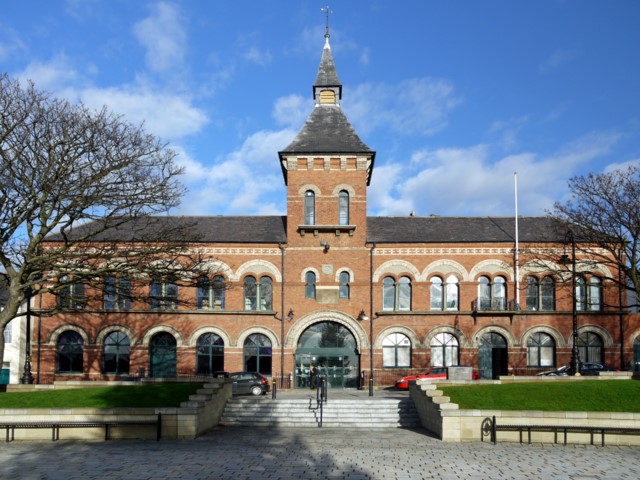
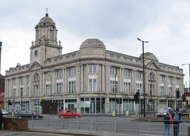
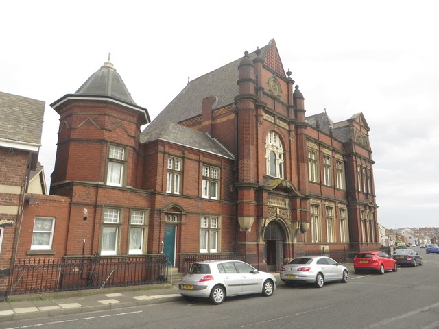
Hartlepool Borough Hall
- Overview Map Street View Hartlepool Borough Hall was built on Middlegate in 1865, by C.J. Adams. The municipal buildings included a market hall. The 3-bay extension to the right of …
Co-Curate Page
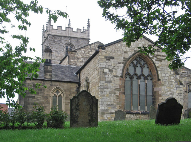
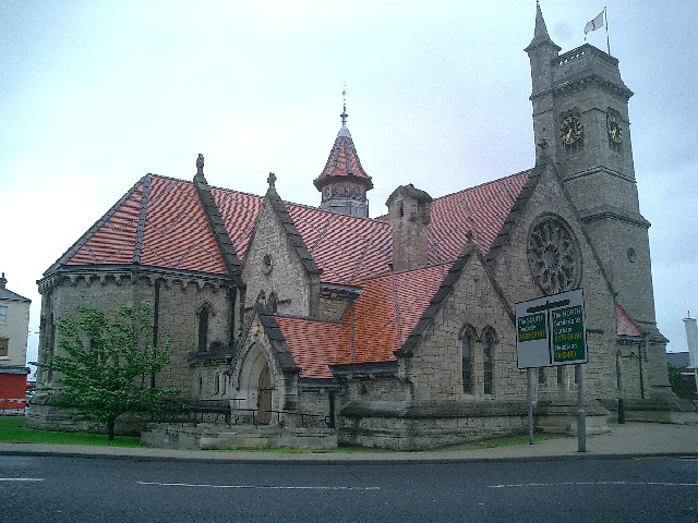
Church of St Hilda
- Overview About St Hilda's Church Map Street View St Hilda's Church on Hartlepool Headland dates from the 13th century, built on the site of a 7th century monastery. The church …
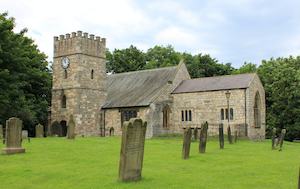
Co-Curate Page
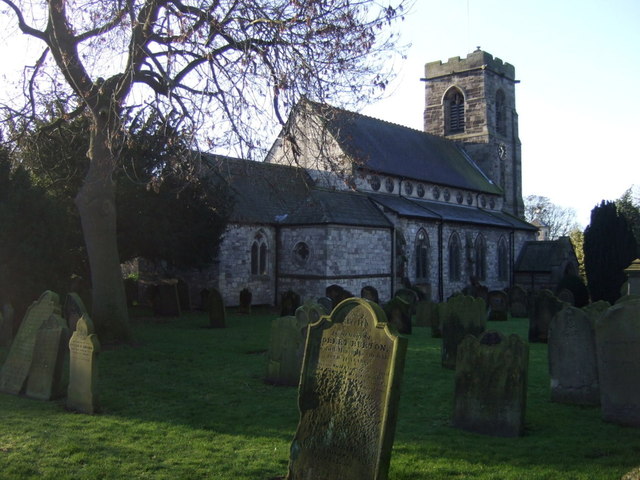
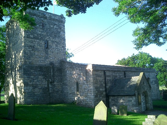
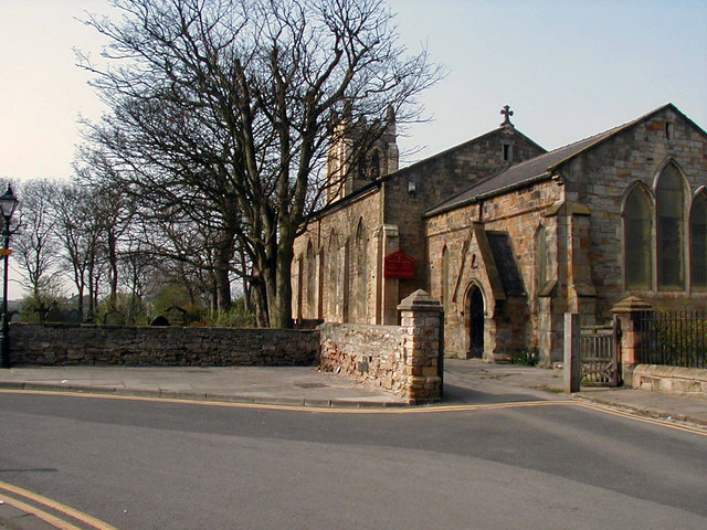
Church of St Peter, Elwick
- Overview Map Street View St Peter's Church is located at the top of Church Bank in Elwick. The church was built in the late 12th century, with a major restoration …
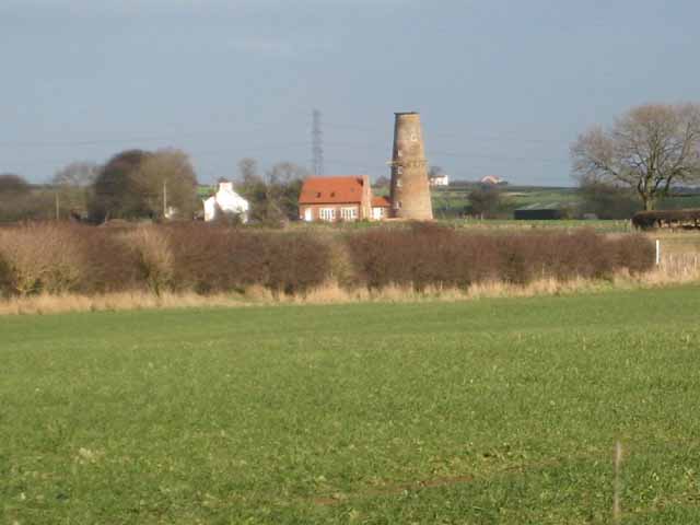
Co-Curate Page
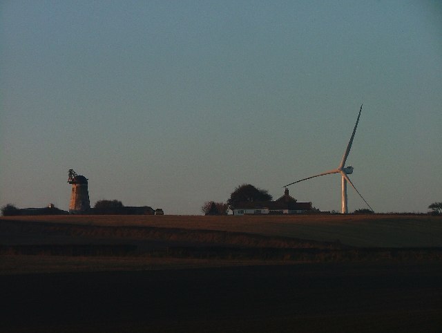
Elwick Windmill
- Overview Map Street View Elwick Windmill was built in the mid 19th century and is located about half a mile south west of Elwick, and is visible from the A19 …
Co-Curate Page
Church of St Andrew
- Overview Map Street View The former Church of St Andrew is located on York Place, Headland in Hartlepool. It was built in 1886 as a Chapel of ease and later …
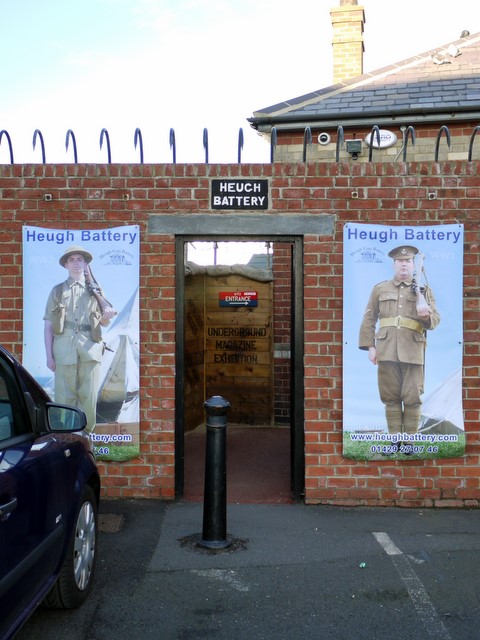
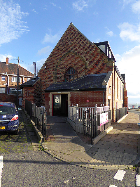
Co-Curate Page
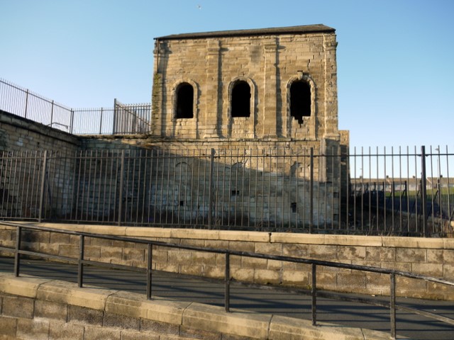
Heugh Battery
- Overview About Heugh Battery Map Street View The Heugh Gun Battery was built on the Headland in 1860 to protect the fast growing port of Hartlepool. The Battery guns were …
Co-Curate Page
Park Tower
- Overview Map Street View Park Tower in Hartlepool is the former North Eastern Co-operative Society department store, located on the corner of Park Road and Stranton. The building was designed by …
Co-Curate Page
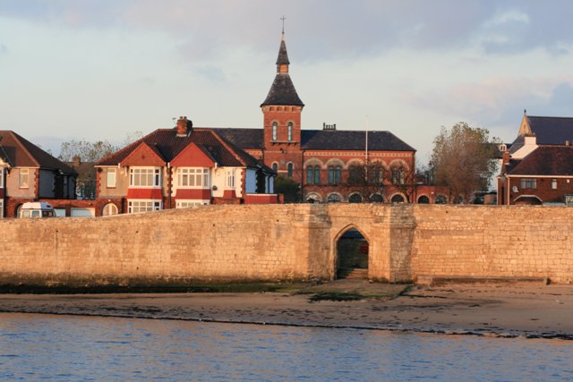
Town Wall and Sandwell Gate
- Map showing Hartlepool Medieval Town Walls superimposed on modern town layout. Position of west-facing walls (demolished in the 1830's) is approximate. The surviving south-facing walls are based on Scheduled Monument …
Co-Curate Page
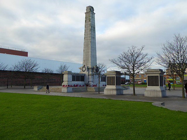
War Memorial
- Overview About the Memorial Map Street View This war memorial is located in Redheugh Gardens, off Cliff Terrace in Headland, Hartlepool. The bronze statue of a winged figure "Triumphant Youth" …
Co-Curate Page
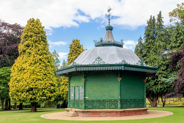
Ward Jackson Park
- Overview About the Park Map Street View This park in Hartlepool is named after Ralph Ward Jackson (1806 - 1880), who founded West Hartlepool in the 19th century. The park was built …
Co-Curate Page
Hospital of God, Greatham
- Overview Map Street View Former almshouse, now residences for the elderly. This is a Grade II listed building. The Hospital of God was originally founded by the Bishop of Durham, Robert …
Co-Curate Page
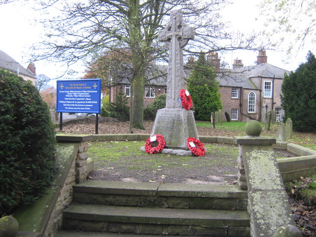
War Memorial, Greatham
- The war memorial in Greatham stands in the churchyard of the St John's Church. The memorial commemorates 13 local servicemen who died during the First World War and was unveiled …
Co-Curate Page
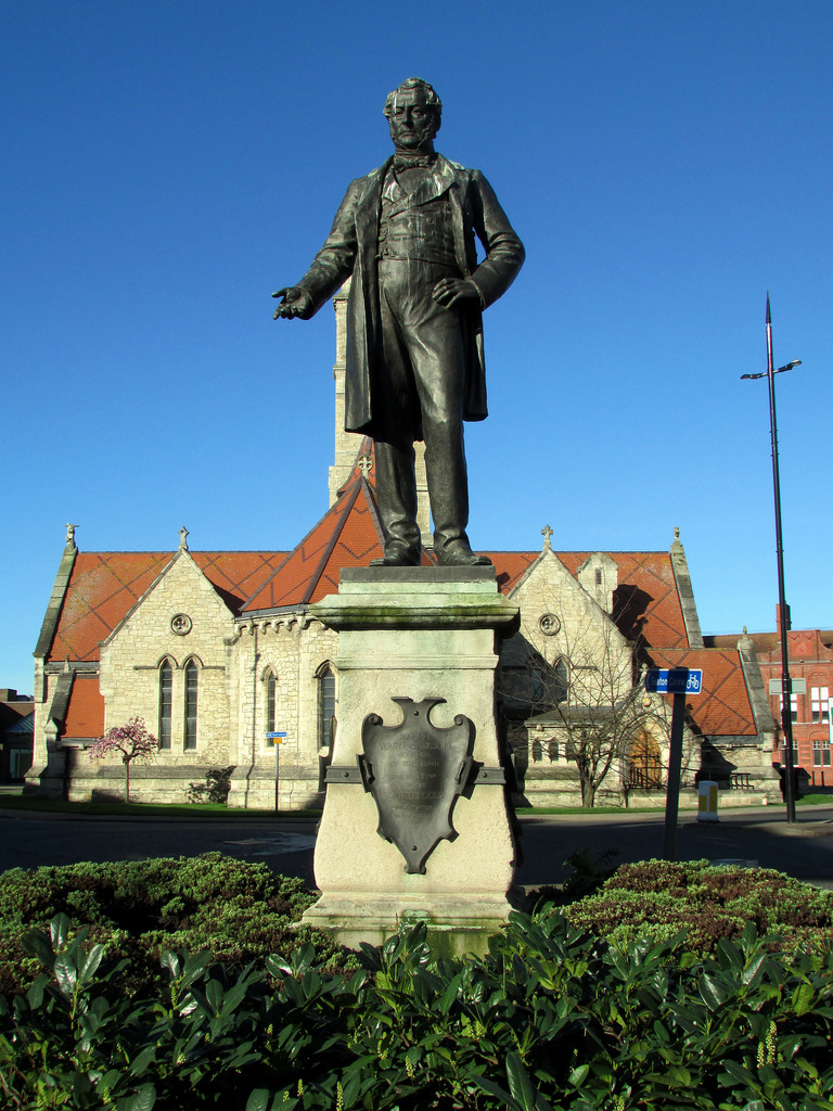
Statue of Ralph Ward Jackson, Church Street
- Overview Map Street View The bronze statue of Ralph Ward Jackson on Church Street in Hartlepool was built in 1897, designed by Edward Onslow Ford.[1] The statue is Grade II …
Co-Curate Page
Municipal Buildings, Church Square
- The former Municipal Buildings on Church Square in Hartlepool are part of the Cleveland College of Art and Design.
Co-Curate Page
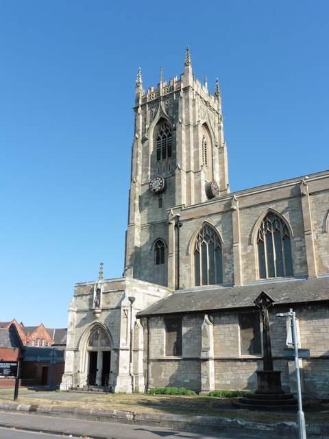
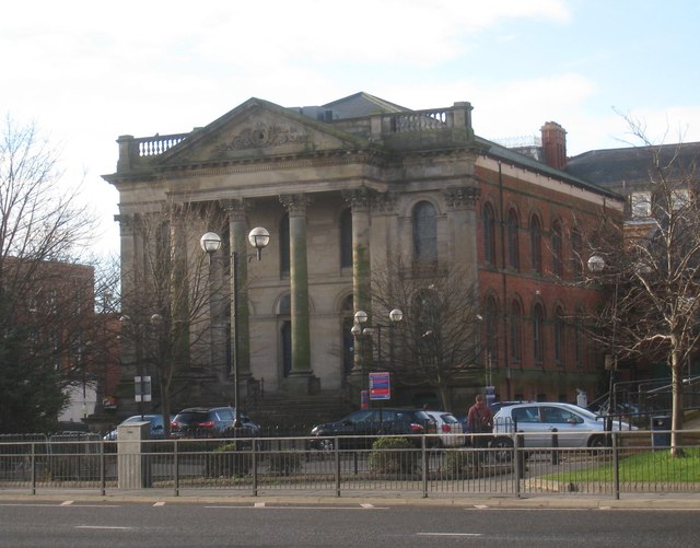
Hartlepool Art Gallery / Christ Church
- Overview About Hartlepool Art Gallery Map Street View Inside Christ Church on Church Square in Hartlepool was built for, what was then, the new and rapidly growing town of West …
Co-Curate Page
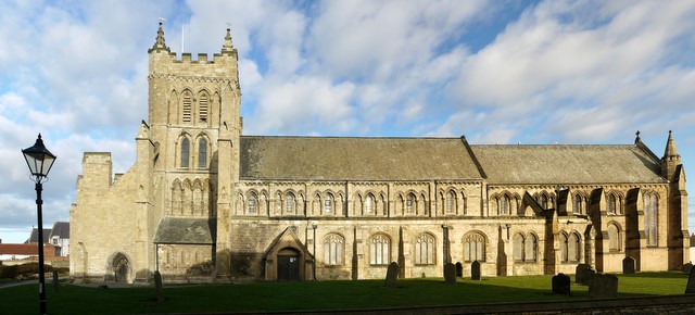
Church of St. Mary Magdalene, Hart
- Overview Map Street View The Church of St. Mary Magdalene in Hart was built in the 11th or 12th century, on the site of earlier churches going back to 675 …
Co-Curate Page
Church of St. Oswald
- Overview Map Street View St. Oswald's church is located on the corner of Brougham Terrace and Millibank Toad in the Dyke House area of Hartlepool. The church was built between …
Co-Curate Page
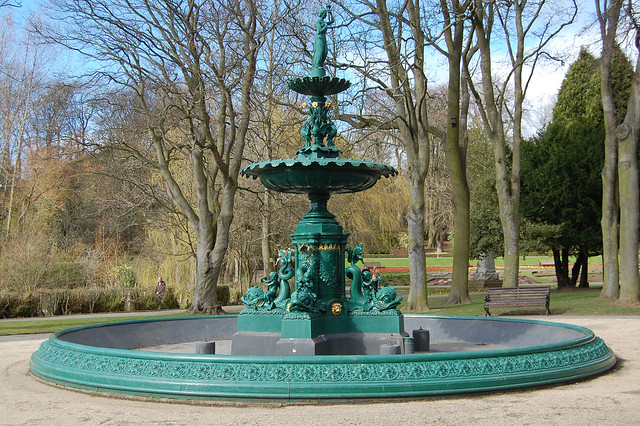
Fountain
- The fountain in Ward Jackson Park was built in 1902. The fountain is Grade II listed on the National Heritage List for England.
Co-Curate Page
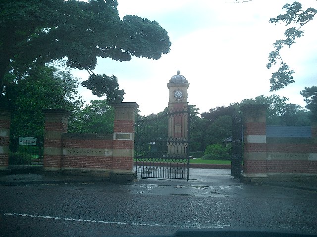
Clock Tower
- The Clock Tower is located by the entrance on the east side of Ward Jackson Park in Hartlepool. It is inscribed: "The gift of Alderman John Brown J.P. Mayor 1902-3-4. …
Co-Curate Page
Church of the Holy Trinity, Seaton Carew
- Overview Map Street View This church in Seaton Carew was originally built as a chapel of ease within the parish of Stranton, designed by T. Pickersgill and consecrated in 1831. Seaton …
Co-Curate Page
Former Wesley Methodist Church
- Overview Map Street View The Wesley Methodist Church on Victoria Road and Raby Road in Hartlepool was built 1871-1873, designed by Hill and Swan. The building is Grade II listed.
Co-Curate Page
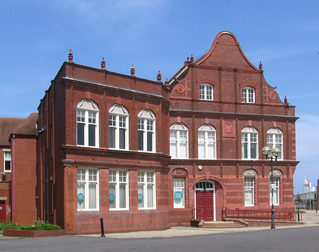
Carnegie Library, Headland
- Overview Map Street View The former Carnegie Library on Northgate in Hartlepool Headland was built in 1903. The building was designed by H.C. Crummack, Borough Engineer.[1] The library and adjoining …
Co-Curate Page
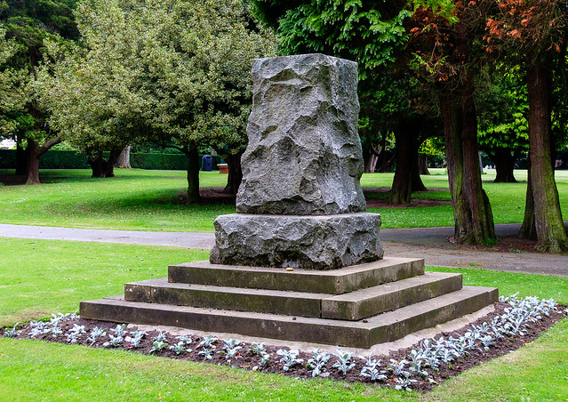
South African War Memorial
- The South African War Memorial in Ward Jackson Park was sculpted by Francis W. Doyle Jones and was unveiled on the 19th of July 1905.[1] The memorial is Grade II …
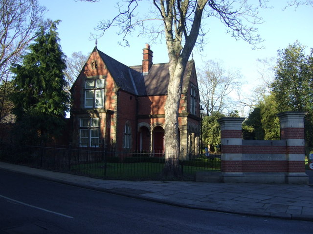
Co-Curate Page
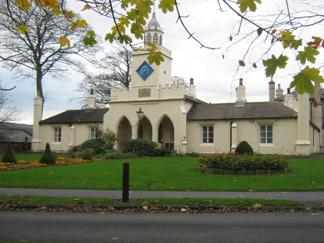
Park Lodge
- The Park Lodge to Ward Jackson Park in Hartlepool is Grade II listed on the National Heritage List for England.
Co-Curate Page
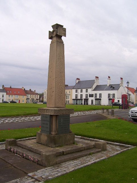
War Memorial, Seaton Carew
- Overview Map Street View The war memorial in Seaton Carew is located on a triangular island located at the north end of The Green, overlooking the Cliff. It was built …
Co-Curate Page
Church of St Joseph, Hartlepool
- Overview Map Street View Inside St Joseph's Church is located on the corner of St Paul's Road and Hutton Avenue in Hartlepool. It is a Roman Catholic church, built 1893 …
Co-Curate Page
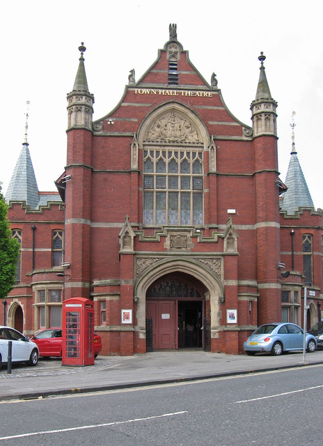
Town Hall Theatre, Hartlepool
- Overview Map Street View "Originally the Town Hall [of West Hartlepool], the building was built in conjunction with the former Technical College (now demolished), with the foundation stone being laid …
Co-Curate Page
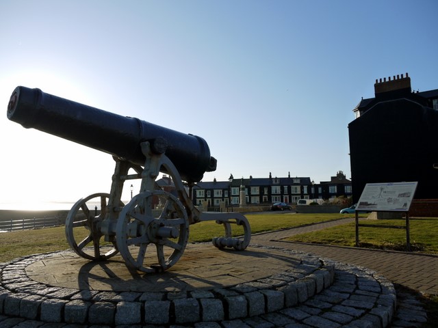
Sebastopol Cannon
- Overview Map Street View The Sebastopol Cannon is located on the Headland at Hartlepool, near the Heugh Battery and Heugh Lighthouse. The cannon was captured from the Russian army at …
Co-Curate Page
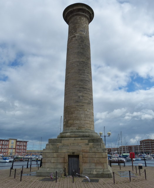
Seaton High Light
- Seaton High Light monument - originally built in 1838 as a river navigation light tower - for the Tees Navigation Company. It was formerly located at the Vulcan Materials UK …
Co-Curate Page
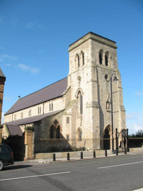
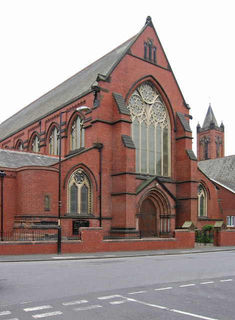
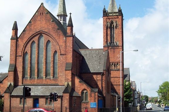
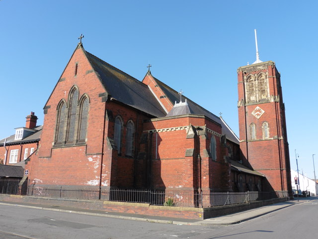
Church of St Paul, Hartlepool
- Overview Map Street View St Paul's Church is located by the junction of Grange Road and St Paul's Road in Hartlepool. The Early English style church was built 1885-1886, by C. …
Co-Curate Page
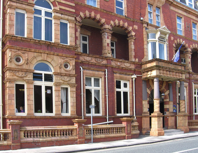
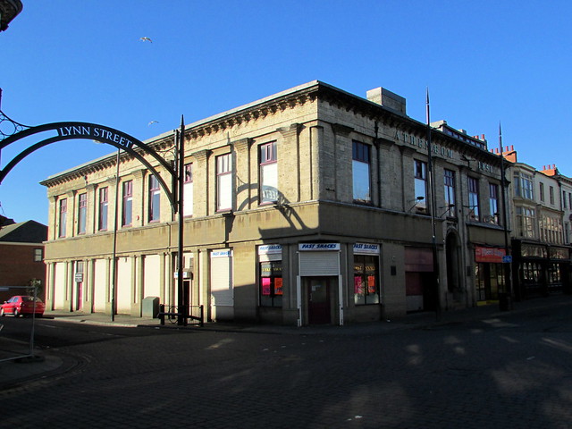
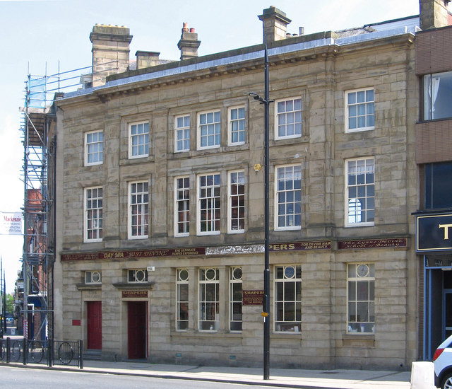
The Athenaeum, Hartlepool
- Overview Map Street View The Athenaeum is located on the corner of Church Street and Lynn Street in Hartlepool. It was originally built in 1851 as West Hartlepool Literary and …
Co-Curate Page
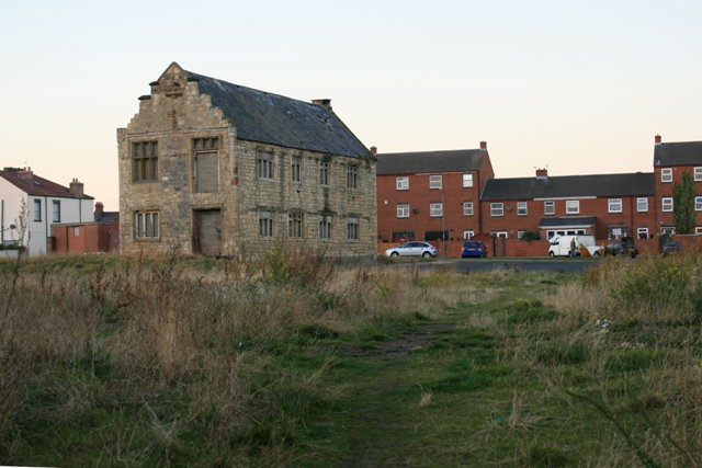
Manor House
- Overview Map Street View This disused building on Friar Street, Headland in Hartlepool was once the north-east wing of the former St. Hilda's Hospital. It was built on the remains …
Co-Curate Page
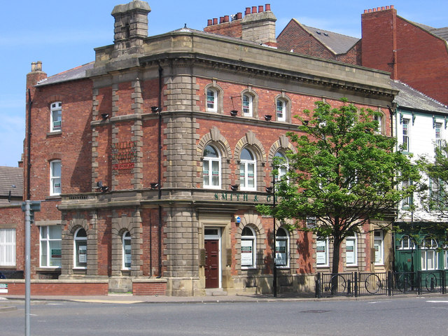
Church Square Chambers, Hartlepool
- Overview Map Street View Church Square Chambers in Hartlepool were built in c.1850. Now Smith and Graham Solicitors. The building is Grade II listed on the National Heritage Lst for …
Co-Curate Page
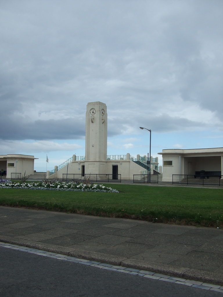
Art Deco bus station and Clock Tower
- Overview Map Street View The distinctive Art Deco style bus station with shelters and central clock tower are located at The Front in Seaton Carew. They were built in 1938, …
Co-Curate Page
38 Church Street
- Overview Map Street View 38 Church Street in Hartlepool is a former Bank, built in 1899, by Barnes and Coates.[1] This is Grade II listed on the National Heritage List …
Co-Curate Page
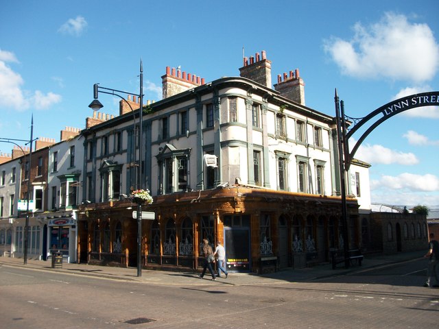
Former Shades Hotel, Church Street
- Overview Map Street View The former Shades Hotel is located on Church Street, on the junction with Lynn Street in Hartlepool. It opened in 1856, in what was at that …

Co-Curate Page
Claxton medieval moated site
- Note: Scheduled Monument area - map data from Historic England c/o Open Data UK, under the Open Government Licence, imported into Google MyMaps, March 2026. The Claxton medieval moated site …
Co-Curate Page
Medieval fishpond and enclosures, north-west of Elwick Hall
- Note: Map data from Historic England c/o Open Data UK, under the Open Government Licence, imported into Google MyMaps, March 2026. Scheduled Monument (#1016353): Fishpond, enclosures and section of field …

Co-Curate Page
Hartlepool Borough Hall
- Overview Map Street View Hartlepool Borough Hall was built on Middlegate in 1865, by C.J. Adams. The municipal buildings included a market hall. The 3-bay extension to the right of …
Co-Curate Page
Church of St Hilda
- Overview About St Hilda's Church Map Street View St Hilda's Church on Hartlepool Headland dates from the 13th century, built on the site of a 7th century monastery. The church …
Co-Curate Page
Church of St Peter, Elwick
- Overview Map Street View St Peter's Church is located at the top of Church Bank in Elwick. The church was built in the late 12th century, with a major restoration …
Co-Curate Page
Elwick Windmill
- Overview Map Street View Elwick Windmill was built in the mid 19th century and is located about half a mile south west of Elwick, and is visible from the A19 …
Co-Curate Page
Church of St Andrew
- Overview Map Street View The former Church of St Andrew is located on York Place, Headland in Hartlepool. It was built in 1886 as a Chapel of ease and later …
Co-Curate Page
Heugh Battery
- Overview About Heugh Battery Map Street View The Heugh Gun Battery was built on the Headland in 1860 to protect the fast growing port of Hartlepool. The Battery guns were …
Co-Curate Page
Park Tower
- Overview Map Street View Park Tower in Hartlepool is the former North Eastern Co-operative Society department store, located on the corner of Park Road and Stranton. The building was designed by …
Co-Curate Page
Town Wall and Sandwell Gate
- Map showing Hartlepool Medieval Town Walls superimposed on modern town layout. Position of west-facing walls (demolished in the 1830's) is approximate. The surviving south-facing walls are based on Scheduled Monument …
Co-Curate Page
War Memorial
- Overview About the Memorial Map Street View This war memorial is located in Redheugh Gardens, off Cliff Terrace in Headland, Hartlepool. The bronze statue of a winged figure "Triumphant Youth" …
Co-Curate Page
Ward Jackson Park
- Overview About the Park Map Street View This park in Hartlepool is named after Ralph Ward Jackson (1806 - 1880), who founded West Hartlepool in the 19th century. The park was built …
Co-Curate Page
Hospital of God, Greatham
- Overview Map Street View Former almshouse, now residences for the elderly. This is a Grade II listed building. The Hospital of God was originally founded by the Bishop of Durham, Robert …
Co-Curate Page
War Memorial, Greatham
- The war memorial in Greatham stands in the churchyard of the St John's Church. The memorial commemorates 13 local servicemen who died during the First World War and was unveiled …
Co-Curate Page
Statue of Ralph Ward Jackson, Church Street
- Overview Map Street View The bronze statue of Ralph Ward Jackson on Church Street in Hartlepool was built in 1897, designed by Edward Onslow Ford.[1] The statue is Grade II …
Co-Curate Page
Municipal Buildings, Church Square
- The former Municipal Buildings on Church Square in Hartlepool are part of the Cleveland College of Art and Design.
Co-Curate Page
Hartlepool Art Gallery / Christ Church
- Overview About Hartlepool Art Gallery Map Street View Inside Christ Church on Church Square in Hartlepool was built for, what was then, the new and rapidly growing town of West …
Co-Curate Page
Church of St. Mary Magdalene, Hart
- Overview Map Street View The Church of St. Mary Magdalene in Hart was built in the 11th or 12th century, on the site of earlier churches going back to 675 …
Co-Curate Page
Church of St. Oswald
- Overview Map Street View St. Oswald's church is located on the corner of Brougham Terrace and Millibank Toad in the Dyke House area of Hartlepool. The church was built between …
Co-Curate Page
Fountain
- The fountain in Ward Jackson Park was built in 1902. The fountain is Grade II listed on the National Heritage List for England.
Co-Curate Page
Clock Tower
- The Clock Tower is located by the entrance on the east side of Ward Jackson Park in Hartlepool. It is inscribed: "The gift of Alderman John Brown J.P. Mayor 1902-3-4. …
Co-Curate Page
Church of the Holy Trinity, Seaton Carew
- Overview Map Street View This church in Seaton Carew was originally built as a chapel of ease within the parish of Stranton, designed by T. Pickersgill and consecrated in 1831. Seaton …
Co-Curate Page
Former Wesley Methodist Church
- Overview Map Street View The Wesley Methodist Church on Victoria Road and Raby Road in Hartlepool was built 1871-1873, designed by Hill and Swan. The building is Grade II listed.
Co-Curate Page
Carnegie Library, Headland
- Overview Map Street View The former Carnegie Library on Northgate in Hartlepool Headland was built in 1903. The building was designed by H.C. Crummack, Borough Engineer.[1] The library and adjoining …
Co-Curate Page
South African War Memorial
- The South African War Memorial in Ward Jackson Park was sculpted by Francis W. Doyle Jones and was unveiled on the 19th of July 1905.[1] The memorial is Grade II …
Co-Curate Page
Park Lodge
- The Park Lodge to Ward Jackson Park in Hartlepool is Grade II listed on the National Heritage List for England.
Co-Curate Page
War Memorial, Seaton Carew
- Overview Map Street View The war memorial in Seaton Carew is located on a triangular island located at the north end of The Green, overlooking the Cliff. It was built …
Co-Curate Page
Church of St Joseph, Hartlepool
- Overview Map Street View Inside St Joseph's Church is located on the corner of St Paul's Road and Hutton Avenue in Hartlepool. It is a Roman Catholic church, built 1893 …
Co-Curate Page
Town Hall Theatre, Hartlepool
- Overview Map Street View "Originally the Town Hall [of West Hartlepool], the building was built in conjunction with the former Technical College (now demolished), with the foundation stone being laid …
Co-Curate Page
Sebastopol Cannon
- Overview Map Street View The Sebastopol Cannon is located on the Headland at Hartlepool, near the Heugh Battery and Heugh Lighthouse. The cannon was captured from the Russian army at …
Co-Curate Page
Seaton High Light
- Seaton High Light monument - originally built in 1838 as a river navigation light tower - for the Tees Navigation Company. It was formerly located at the Vulcan Materials UK …
Co-Curate Page
Church of St Paul, Hartlepool
- Overview Map Street View St Paul's Church is located by the junction of Grange Road and St Paul's Road in Hartlepool. The Early English style church was built 1885-1886, by C. …
Co-Curate Page
The Athenaeum, Hartlepool
- Overview Map Street View The Athenaeum is located on the corner of Church Street and Lynn Street in Hartlepool. It was originally built in 1851 as West Hartlepool Literary and …
Co-Curate Page
Manor House
- Overview Map Street View This disused building on Friar Street, Headland in Hartlepool was once the north-east wing of the former St. Hilda's Hospital. It was built on the remains …
Co-Curate Page
Church Square Chambers, Hartlepool
- Overview Map Street View Church Square Chambers in Hartlepool were built in c.1850. Now Smith and Graham Solicitors. The building is Grade II listed on the National Heritage Lst for …
Co-Curate Page
Art Deco bus station and Clock Tower
- Overview Map Street View The distinctive Art Deco style bus station with shelters and central clock tower are located at The Front in Seaton Carew. They were built in 1938, …
Co-Curate Page
38 Church Street
- Overview Map Street View 38 Church Street in Hartlepool is a former Bank, built in 1899, by Barnes and Coates.[1] This is Grade II listed on the National Heritage List …
Co-Curate Page
Former Shades Hotel, Church Street
- Overview Map Street View The former Shades Hotel is located on Church Street, on the junction with Lynn Street in Hartlepool. It opened in 1856, in what was at that …
Co-Curate Page
Claxton medieval moated site
- Note: Scheduled Monument area - map data from Historic England c/o Open Data UK, under the Open Government Licence, imported into Google MyMaps, March 2026. The Claxton medieval moated site …


