Topics > Northumberland > Civil Parishes in Northumberland > Stannington Civil Parish > Historic Buildings and Monuments in Stannington Civil Parish
Historic Buildings and Monuments in Stannington Civil Parish
Listed buildings and scheduled monuments in Stannington Civil Parish, Northumberland, from the National Heritage List for England[1]. In the absence of a published 'local list', some other public buildings of interest may also be included. Use the Search (below) if looking for a specific building / monument.
| Structure | List No. | Grade | Built~ | Note |
|---|---|---|---|---|
| St Mary's Hospital, Stannington (grounds) | 1001478 |
II |
1914 | Listed Park & Garden. St Mary's Park |
| Blagdon (grounds) | 1001043 |
II |
C18th | Listed Park & Garden. Later additions by Sir Edwin Lutyens & Gertrude Jekyll. Blagdon Estate |
| Nos. 1-3, New Horton Grange | 1299466 | II | 1858 | Horton Grange |
| Barn and Adjacent Stable Range Ot South West of East Moor Farmhouse | 1237319 | II | C18th | East Moor |
| Barn and Gingang to North West of Duddo Hill Farmhouse | 1237317 | II | C19th | Duddo Hill |
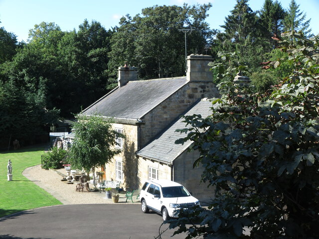
| Beech Cottage | 1264124 | II | C18th | Stannington |
| Bellasis Bridge, over the River Blyth | 1370762 | II | C16th | Bellasis. Scheduled Monument(1006607) |
| Bellasis Farmhouse, Attached Wall and Outbuilding | 1206670 | II | 1694 | Bellasis |
| Blagdon Hall | 1042662 | I | 1752 | Blagdon Estate |
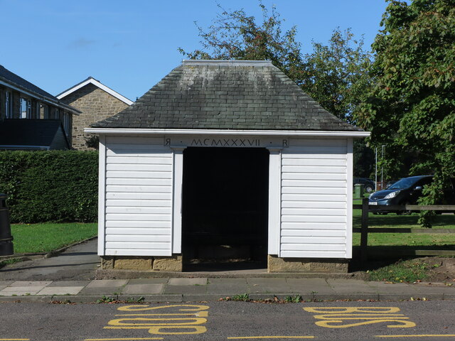
| Bus Shelter 10 Metres South of Footbridge | 1206664 | II | 1937 | Stannington |
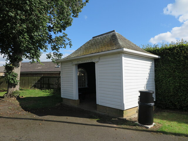
| Bus Shelter 45 Metres North of Footbridge | 1042661 | II | 1937 | Stannington |
| Cale Cross, 60 Metres North of North Lodge | 1042624 | II | 1785 | Relocated from Newcastle to Blagdon in 1807. |
| Canal with Basin Urns and Statue, to South of Blagdon Hall | 1247870 | II* | c.1920s | Blagdon Estate. Statue, 1863 |
| Cartshed to East of Main Farmbuilding Group | 1264169 | II | 1868 | Glororum |
| Chimney 60 Metres East of North Shotton Farmhouse | 1237370 | II | 1860 | Shotton |
| Church of St Mary the Virgin | 1042627 | II | 1871 | Stannington |
| Churchyard Cross 15 Metres North East of Church of St Mary | 1370787 | II | c.1890 | Stannington |
| Coates Tomb 11 Metres South West of Church of St Mary | 1237313 | II | 1763 | Stannington |
| Deepdale | 1237388 | II | c.1860 | Stannington. Cottage. |
| Drinking Fountain 90 Metres South East of the Old Vicarage | 1025123 | II | 1902 | Stannington |
| Duddo Hill Farmhouse | 1237316 | II | C18th | Duddo Hill |
| East Moor Farmhouse with Farmbuilding to West | 1237318 | II | C18th | East Moor |
| Entrance Screen Adjacent to North Lodge | 1187688 | II | 1887 | |
| Farm Building Attached to Number 4 | 1024969 | II | 1858 | New Horton Grange |
| Farm Buildings and Garage North of Horton Grange Farmhouse | 1024968 | II | 1858 | Horton Grange |
| Farm Buildings to West of Horton Grange Farmhouse | 1355217 | II | c.1858 | Horton Grange |
| Garden Wall and Outbuildings, South of North Shotton Farmhouse | 1264154 | II | C18th | Shotton |
| Garden Wall to South of South Shotton House | 1237371 | II | c.1800 | Shotton |
| Garden Wall, Gatepiers and Gate, West of North Shotton Farmhouse | 1237369 | II | C19th | Shotton |
| Garden Walls to East and South of the Old Vicarage | 1042626 | II | C18th | Stannington |
| Garden Walls, Attached Outbuildings, Greenhouse and Pillars, West of Blagdon Hall | 1206715 | II | C18th | Blagdon Estate |
| Gatepiers to West of Grove Pond, 300 Metres South of Blagdon Hall | 1263886 | II | c.1914 | Blagdon Estate |
| Gillespy Headstone 3 Metres South of Church of St Mary | 1237312 | II | 1744 | Stannington |
| Gin Gang on West Side of Barn to South West of Briery Hill Farmhouse | 1370786 | II | C19th | Briery Hill |
| Gothick Ruin 200 Metres North East of Blagdon Hall | 1042622 | II | C19th | Blagdon Estate |
| Hall Tomb 2 Metres East of Church of St Mary | 1355125 | II | 1815 | Stannington |
| Holly Cottage | 1237341 | II | C19th | By Old A1 |
| Horton Grange Farmhouse | 1355216 | II | 1864 | Horton Grange |
| Ice House 20 Metres East of South End of Stone Bridge | 1042621 | II | C18th | Blagdon Estate |
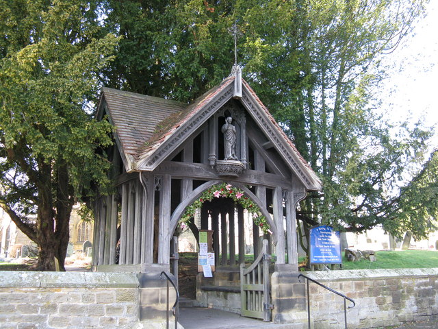
| Lych Gate to Church of St Mary the Virgin | 1355122 | II | 1893 | Stannington |
| Main Farmbuilding Group on North Side of Road | 1237320 | II | C19th | Glororum |
| Medieval Cross Remains in North Wood | 1187710 | II | C13th | Blagdon Estate |
| Middle Duddo Farmhouse and Adjacent Outbuildings | 1237338 | II | C18th | Middle Duddo |
| Milepost East of Road 50 Metres North of Blagdon North Lodge | 1237340 | II | C19th | Old A1 road |
| Milepost East of Road 80 Metres South of Swan Farmhouse | 1237372 | II | C19th | Stannington |
| Milkhope Farm Cottages Nos 1-4 Consecutive, with Walls and Privy/Stores Attached | 1042625 | II | C19th | Milkhope |
| Milkhope Farmhouse | 1370785 | II | 1806 | Milkhope |
| Moor Tomb 5 Metres East of South Aisle of Church of St Mary | 1025103 | II | 1787 | Stannington |
| North Lodge and Attached Wall to South | 1042623 | II | 1887 | Blagdon Estate |
| North Shotton Farmhouse | 1237368 | II | C18th | Shotton |
| Old Boathouse to East of North End of the White Bridge | 1187699 | II | C18th | Blagdon Estate |
| Old Hearse House to North of Ridley Arms | 1237373 | II | 1871 | Stannington |
| Old Horton Grange | 1264153 | II | C17th | Horton Grange |
| Outbuilding 10 Metres North of Holly Cottage | 1264139 | II | C19th | Off Old A1 |
| Outbuilding East of Middle Duddo Farmhouse | 1237339 | II | C17th | Middle Duddo |
| Outbuilding to South of East Moor Farmhouse | 1264168 | II | C18th | East Moor |
| Pond with Surrounding Walls, Benches and Urns, 300 Metres West of Blagdon Hall | 1263923 | II | c.1920s | Blagdon Estate |
| Premises Belonging to H Irwin and Son | 1264138 | II | C19th | Off Old A1 |
| Railway Viaduct over the River Blyth | 1365310 | II | C19th | Plessey Woods |
| Rose Cottage | 1237387 | II | C19th | Stannington |
| Shotton Grange | 1237342 | II | c.1800 | Off Old A1 |
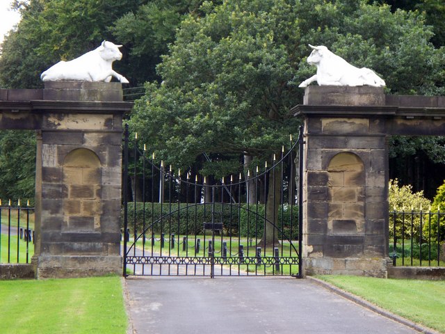
| South Lodges, Gate Screen and Gates | 1298582 | II* | 1787 | Blagdon Estate |
| South Shotton Edge Cottage and Adjacent Outbuildings | 1264152 | II | C19th | Off Old A1 |
| South Shotton Edge House | 1237343 | II | C19th | Off Old A1 |
| South Shotton House | 1264155 | II | c.1800 | Shotton |
| Stable Block to North of Blagdon Hall Including Archway, Courtyard and Drummonds' Flats | 1370782 | II* | 1791 | Blagdon Estate |
| Statuary in Sculpture Garden, 40 Metres South East of Stone Bridge | 1206721 | II | C19th | Blagdon Estate |
| Stone Coffin and Font Bowl Against South Wall of Church of St Mary | 1370788 | II | C12th | Stannington |
| Summerhouse 400 Metres East of Blagdon Hall | 1187704 | II | C18th | Blagdon Estate |
| Summerhouse at East End of Grove Pond, 300 Metres South East of Blagdon Hall | 1280124 | II | c.1914 | Blagdon Estate |
| Sunken Garden Walls and Pergolas 120 Metres South West of Blagdon Hall | 1247873 | II | c.1920s | Blagdon Estate |
| Swam Farmhouse | 1264117 | II | C18th | Stannington |
| Temple on North Bank of Lake | 1370784 | II | 1783 | Blagdon Estate |
| Terrace and Walk with Ornamental Features to South and West of Blagdon Hall | 1247874 | II | c.1920s | Blagdon Estate |
| The Iron Bridge 200 Metres North West of Blagdon Hall | 1263924 | II | 1881 | Blagdon Estate |
| The Milkhope Centre | 1025241 | II | 1865 | Milkhope |
| The Old Vicarage | 1025120 | II | 1745 | Stannington |
| The Seed House, South West of Blagdon Hall Stables, with Wall to East | 1206683 | II | C19th | Blagdon Estate |
| The Stone Bridge, 160 Metres North of Blagdon Hall | 1042620 | II | 1860 | Blagdon Estate |
| The White Bridge, 150 Metres North East of Blagdon Hall | 1370783 | II | C18th | Blagdon Estate |
| Urn 20 Metres North of Temple | 1247872 | II | C18th | Blagdon Estate |
| Urn on Island in Drive 80 Metres North East of Blagdon Hall | 1247871 | II | c.1920s | Blagdon Estate |
| Vale House, with Attached Pier, Wall and Railings | 1206666 | II | C18th | Stannington Vale |
| Villa Rose | 1370763 | II | c.1791 | Blagdon Estate former kitchen wing, now house. |
| Walls, Gate Piers and Gates in Front of Horton Grange | 1024967 | II | c.1864 | Horton Grange |
| West House Farmhouse | 1237389 | II | c.1800 | West House Farm |
| Young Headstone 2.5 Metres South of Church of St Mary | 1042628 | II | 1762 | Stannington |
| Stannington Railway Station | Not Listed | n/a | 1847 | Stannington Station. Closed 1958. |
| Stannington Village Hall | Not Listed | n/a | 1959 | Stannington |
| St Mary's Village Hall | Not Listed | n/a | c.1910s | St Mary's Park. Former hospital chapel. |
| St Mary's Inn | Not Listed | n/a | c.1910 | St Mary's Park. Former hospital administration block |
| The Ridley Arms | Not Listed | n/a | C18th? | Stannington. Former coaching inn. |
Primary source: the National Heritage List for England - NHLE is the register of nationally protected historic buildings and sites in England, including listed buildings, scheduled monuments, protected wrecks, registered parks and gardens, and battlefields. The list is maintained by Historic England. Check NHLE for updates and new entries. Secondary sources: British Listed Buildings and Keys to the Past. Non-listed buildings may be included from a ‘local list’, or added on an ad-hoc basis by Co-Curate members if a ‘local list’ has not been published by the relevant council.
Co-Curate Page
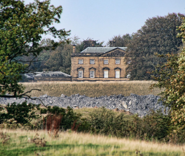
Blagdon Hall
- Overview Map Blagdon Hall is a privately owned country house situated off the Old A1 road in Northumberland. The current Hall was built in two phases between 1730 and 1752. …
Co-Curate Page
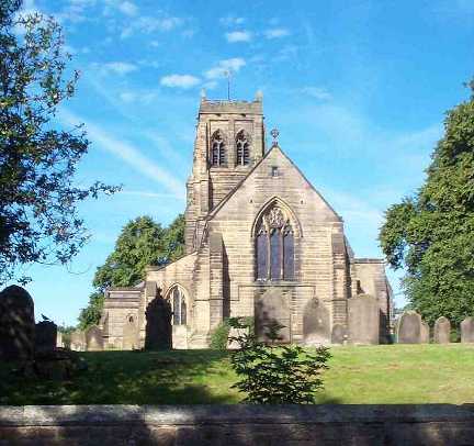
Church of St. Mary the Virgin, Stannington
- Overview Map Street View Inside The Church of St. Mary the Virgin is located on Church Road in Stannington, Northumberland. There has been a church on this site since at …
Co-Curate Page
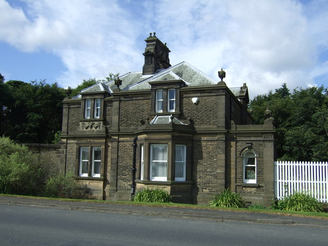
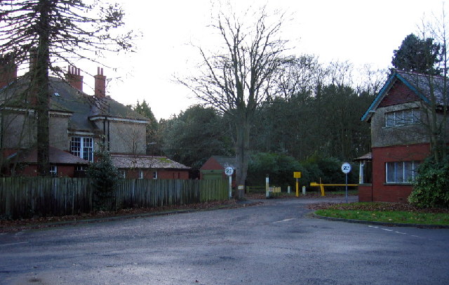
North Lodge - Balgdon Estate
- The North Lodge was built in 1887 as a gate lodge for the north entrance to Blagdon Hall. It is located on the old Great North Road near Stannington and is part of the …
Co-Curate Page
St Mary's Hospital, North Saltwick (1914 - 1995)
- Overview About St Mary's Hospital Map St Mary's Hospital, near North Saltwick and about 2 miles north-west of Stannington in Northumberland, originally opened as Gateshead Borough Lunatic Asylum in 1914. …
Co-Curate Page
Bellasis
- Overview Map Street View Bellasis is a farmstead located about a mile south-west of Stannington in Northumberland. It is the site of the old manor of Bellasis, which was owned …
Co-Curate Page
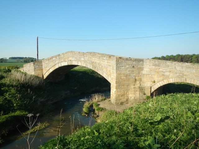
Bellasis Bridge
- Overview Map Street View Bellasis Bridge carries Green Lane over the River Blyth. It is located about half a mile souuth-west of the Bellasis and 2 miles south-west from Stannington. …
Co-Curate Page
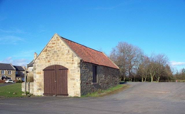
Duddo Hill
- Overview Map Street View Duddo Hill is a farm, located about 1½ miles north-west of the village of Stannington in Northumberland. The farmhouse here dates from the 18th Century, with …
Co-Curate Page
Barn and Gingang, Duddo Hill Farm
- The barn and gingang at Duddo Hill farm date from the early 19th Century and are Grade II listed on the National Heritage List for England.
Co-Curate Page
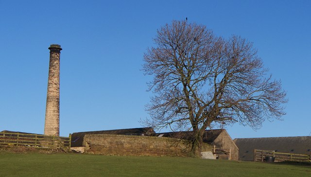
Chimney on North Shotton Farm
- Overview Map Street View This old engine house chimney is located by North Shotton farmhouse, in Shotton, Northumberland. The chimney is dated 1860 with initials MWR (Matthew White Ridley). The …
Co-Curate Page
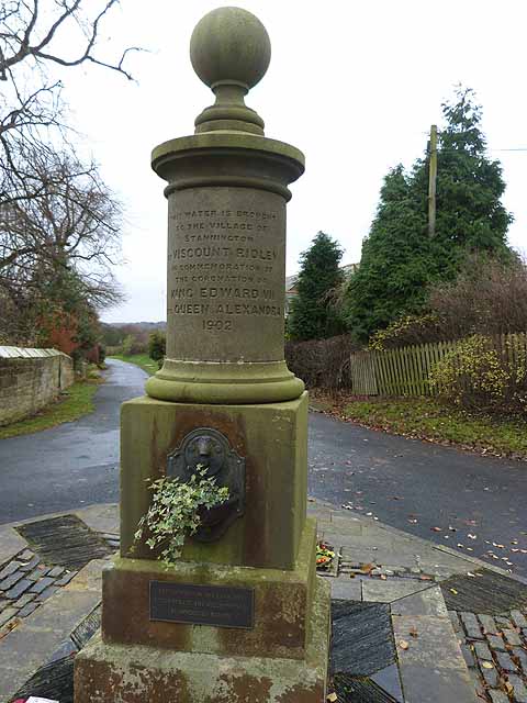
Old Drinking Fountain, Stannington
- Overview Map Street View This old drinking fountain is in a prominent location on Church Road in Stannington. The stone fountain is located on a triangular island at a road …

Co-Curate Page
Old Milepost near Blagdon North Lodge
- Overview Map Street View This old Milepost is on the grass verge by the Old A1 road near Blagdon North Lodge, about 1 mile south of Stannington, shows the distances …
Co-Curate Page
Old Milestone, Stannington
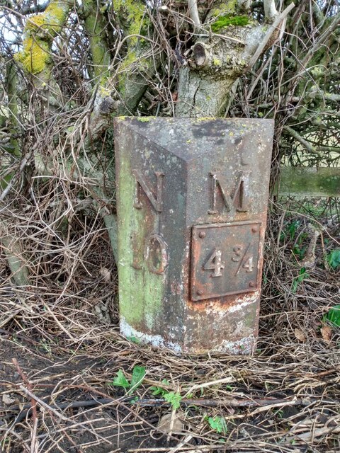
- Overview This old Milepost is on the grass verge by the old Great North Road near Swan Farmhouse at the south of Stannington, shows the distances in miles to Newcastle …
Co-Curate Page
Bus Shelter (North)
- Overview Map Street View This distinctive bus shelter in Stannington, is by Laurence Whistler, and dated 1937 inscribed in Roman numerals on the lintel. It stands on the old Great …
Co-Curate Page
Bus Shelter (South)
- Overview Map Street View This distinctive bus shelter in Stannington, is by Laurence Whistler, and dated 1937 inscribed in Roman numerals on the lintel. It stands on the old Great …
Co-Curate Page
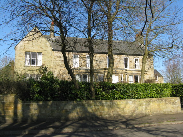
The Old Vicarage, Stannington
- Overview Map Street View The Old Vicarage is located on Church Road, to east of St Mary's Church, in Stannington, Northumberland. It was originally built in 1745, with the addition …
Co-Curate Page
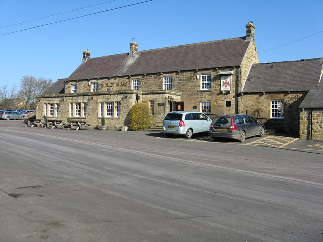
The Ridley Arms, Stannington
- The Ridley Arms in Stannington was built as a coaching inn on what was the Great North Road. It was previously called the Howard Arms after the Howard Family (Earls …
Co-Curate Page
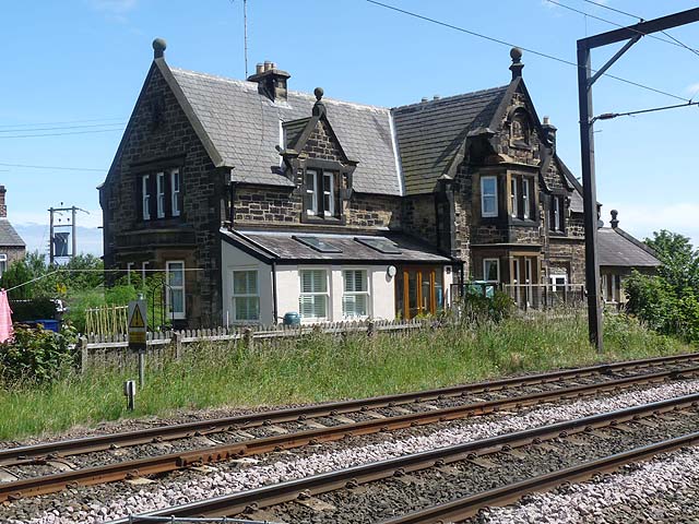
Stannington Railway Station (1847 - 1964)
- Overview Map Street View The railway station, located part way between the villages of Stannington and Netherton, was opened on the 1st of March 1847 by the Newcastle & Berwick …
Co-Curate Page
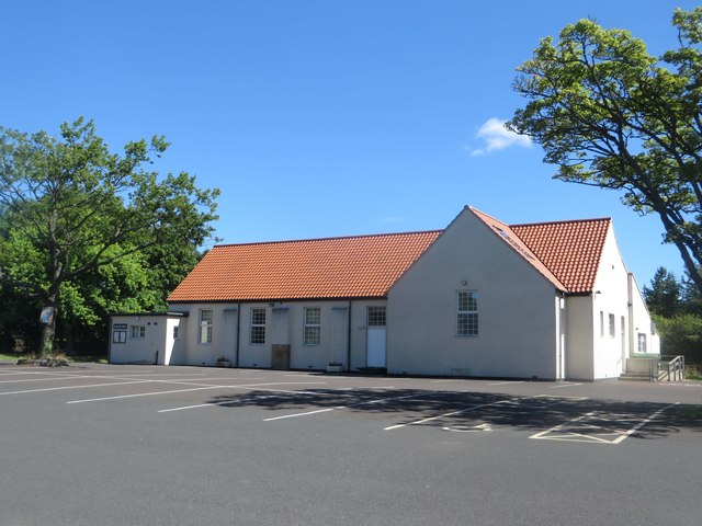
Village Hall, Stannington
- Overview Map Street View The Village Hall is located off Main Street in Stannington. It was opened on the 24th of October 1959.
Co-Curate Page
Vale House, Stannington Vale
- Overview Map Street View Vale House is located in Stannington Vale, by the River Blyth and a short distance west of Stannington Bridge. The house was built in the late …

Co-Curate Page
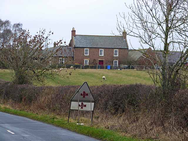
Shotton Grange
- Overview Map Street View Inside Shotton Grange is a wedding venue, located on the Old A1, north of Newcastle. The building dates from the late 18th century and was originally …

Co-Curate Page
Blagdon Hall
- Overview Map Blagdon Hall is a privately owned country house situated off the Old A1 road in Northumberland. The current Hall was built in two phases between 1730 and 1752. …
Co-Curate Page
Church of St. Mary the Virgin, Stannington
- Overview Map Street View Inside The Church of St. Mary the Virgin is located on Church Road in Stannington, Northumberland. There has been a church on this site since at …
Co-Curate Page
North Lodge - Balgdon Estate
- The North Lodge was built in 1887 as a gate lodge for the north entrance to Blagdon Hall. It is located on the old Great North Road near Stannington and is part of the …
Co-Curate Page
St Mary's Hospital, North Saltwick (1914 - 1995)
- Overview About St Mary's Hospital Map St Mary's Hospital, near North Saltwick and about 2 miles north-west of Stannington in Northumberland, originally opened as Gateshead Borough Lunatic Asylum in 1914. …
Co-Curate Page
Bellasis
- Overview Map Street View Bellasis is a farmstead located about a mile south-west of Stannington in Northumberland. It is the site of the old manor of Bellasis, which was owned …
Co-Curate Page
Bellasis Bridge
- Overview Map Street View Bellasis Bridge carries Green Lane over the River Blyth. It is located about half a mile souuth-west of the Bellasis and 2 miles south-west from Stannington. …
Co-Curate Page
Duddo Hill
- Overview Map Street View Duddo Hill is a farm, located about 1½ miles north-west of the village of Stannington in Northumberland. The farmhouse here dates from the 18th Century, with …
Co-Curate Page
Barn and Gingang, Duddo Hill Farm
- The barn and gingang at Duddo Hill farm date from the early 19th Century and are Grade II listed on the National Heritage List for England.
Co-Curate Page
Chimney on North Shotton Farm
- Overview Map Street View This old engine house chimney is located by North Shotton farmhouse, in Shotton, Northumberland. The chimney is dated 1860 with initials MWR (Matthew White Ridley). The …
Co-Curate Page
Old Drinking Fountain, Stannington
- Overview Map Street View This old drinking fountain is in a prominent location on Church Road in Stannington. The stone fountain is located on a triangular island at a road …
Co-Curate Page
Old Milepost near Blagdon North Lodge
- Overview Map Street View This old Milepost is on the grass verge by the Old A1 road near Blagdon North Lodge, about 1 mile south of Stannington, shows the distances …
Co-Curate Page
Old Milestone, Stannington
- Overview This old Milepost is on the grass verge by the old Great North Road near Swan Farmhouse at the south of Stannington, shows the distances in miles to Newcastle …
Co-Curate Page
Bus Shelter (North)
- Overview Map Street View This distinctive bus shelter in Stannington, is by Laurence Whistler, and dated 1937 inscribed in Roman numerals on the lintel. It stands on the old Great …
Co-Curate Page
Bus Shelter (South)
- Overview Map Street View This distinctive bus shelter in Stannington, is by Laurence Whistler, and dated 1937 inscribed in Roman numerals on the lintel. It stands on the old Great …
Co-Curate Page
The Old Vicarage, Stannington
- Overview Map Street View The Old Vicarage is located on Church Road, to east of St Mary's Church, in Stannington, Northumberland. It was originally built in 1745, with the addition …
Co-Curate Page
The Ridley Arms, Stannington
- The Ridley Arms in Stannington was built as a coaching inn on what was the Great North Road. It was previously called the Howard Arms after the Howard Family (Earls …
Co-Curate Page
Stannington Railway Station (1847 - 1964)
- Overview Map Street View The railway station, located part way between the villages of Stannington and Netherton, was opened on the 1st of March 1847 by the Newcastle & Berwick …
Co-Curate Page
Village Hall, Stannington
- Overview Map Street View The Village Hall is located off Main Street in Stannington. It was opened on the 24th of October 1959.
Co-Curate Page
Vale House, Stannington Vale
- Overview Map Street View Vale House is located in Stannington Vale, by the River Blyth and a short distance west of Stannington Bridge. The house was built in the late …

