Topics > Heritage Sites > Scheduled Monument > Scheduled Monuments in Westmorland and Furness
Co-Curate Page
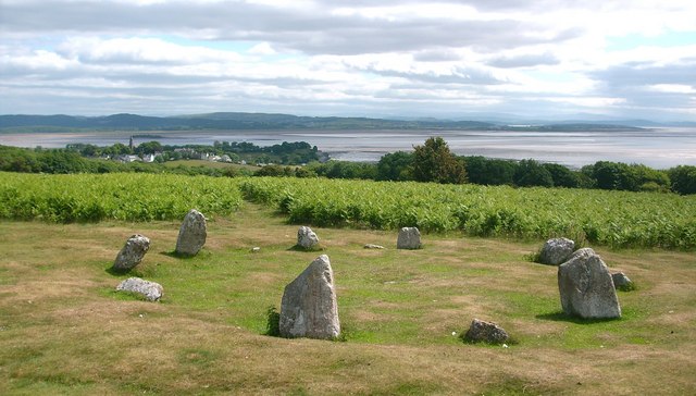
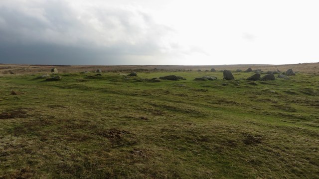
Birkrigg Stone Circle
- Overview About Birkrigg Stone Circle Map Street View Birkrigg Stone Circle (also known as the Druid's Circle) is located on Birkrigg Common in Cumbria, located about 2 miles south of …
Co-Curate Page
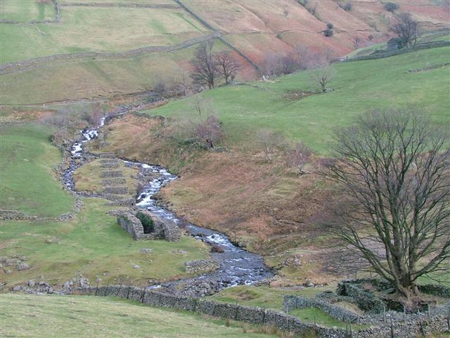
Myers Head Lead Mine
- The remains of Myers Head Lead Mine are located by the confluence of Pasture Beck and Hayeswater Gill, south-east of Hartsop in the Eden district of Cumbria.
Co-Curate Page
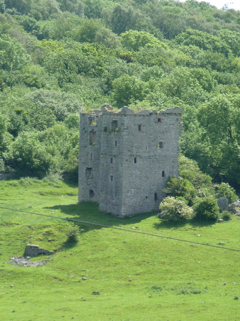
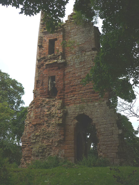
Arnside Tower
- Overview About Arnside Tower Map Street View Arnside Tower is a late-medieval tower house located about half a mile south of the village of Arnside and a similar distance north-east …
Co-Curate Page
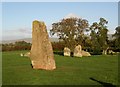
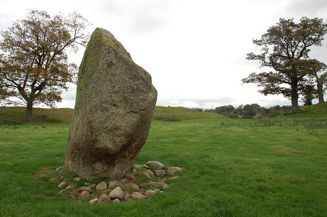
Long Meg and Her Daughters (stone circle)
- Overview About Long Meg and Her Daughters Map Street View Long Meg and Her Daughters is a stone circle in Cumbria, located about half a mile north-east of the village …
Co-Curate Page
Kirkoswald Castle
- Overview About Kirkoswald Castle Map Street View The ruins of Kirkoswald Castle are located to the south-east of Kirkoswald in Cumbria. A licence to crenellate (fortify) an existing building was granted …
Co-Curate Page
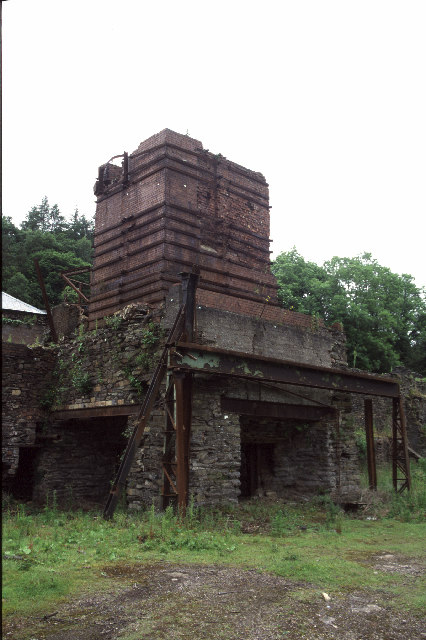
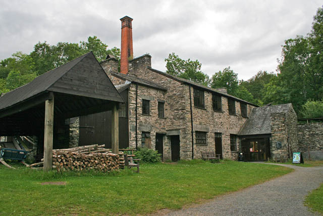
Backbarrow Ironworks
- Established in 1711. Isaac Wilkinson worked here, he developed a furnace fuelled by charcoal and was one of the first of its kind in the UK.The main products of the …
Co-Curate Page
Croglam Castle (Iron Age site)
- Overview Map This is a Scheduled Monument at the south-west of Kirkby Stephen. It includes the earthwork and buried remains of a defended settlement of Iron Age date, situated on …
Co-Curate Page
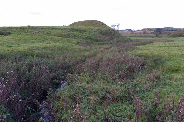
Mayburgh Henge
- Overview About Mayburgh Henge Map Street View Henges are ritual or ceremonial sites which date to the Late Neolithic period (2800-2000 BC). Mayburgh Henge is located close to the confluence …
Co-Curate Page
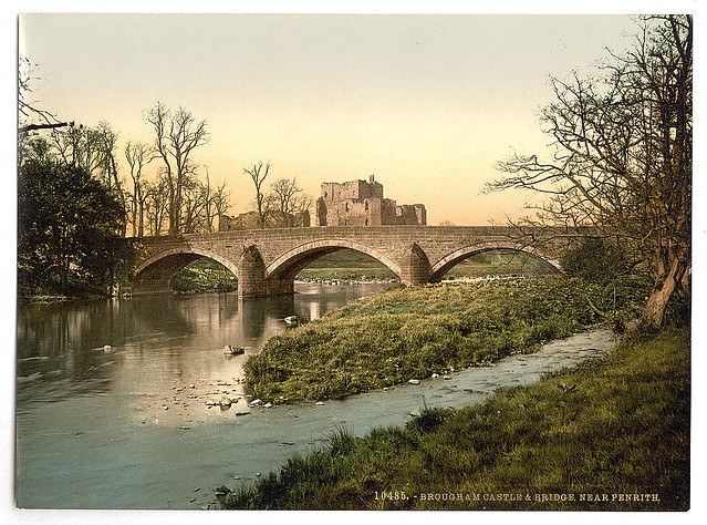
Brougham Castle
- Overview About Brougham Castle Map Street View Located about a mile south-east of Penrith in Cumbria. Brougham Castle (pronounced /ˈbruːm/) is a medieval building about 2 miles (3.2 km) south-east …
Co-Curate Page
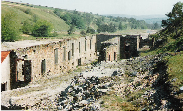
Low Wood Gunpowder Works
- Overview About Low Wood Gunpowder Works Map Street View The Low Wood Gunpowder Works, located on the east banks of the River Leven at Low Wood, were in operation from …
Co-Curate Page
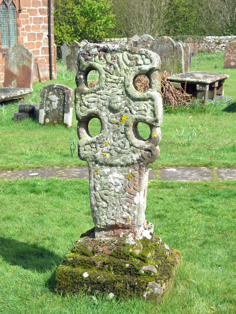
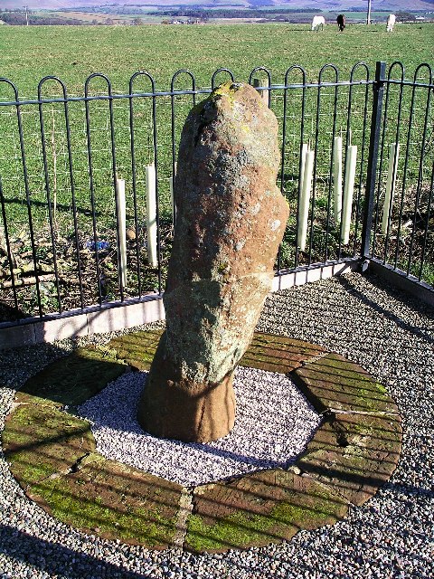
Addingham Cross
- The 'Addingham Cross' is a late 10th or early 11th century Saxon stone cross in the churchyard of St Michael's Church, Glassonby. The cross was originally located in the churchyard …
Co-Curate Page
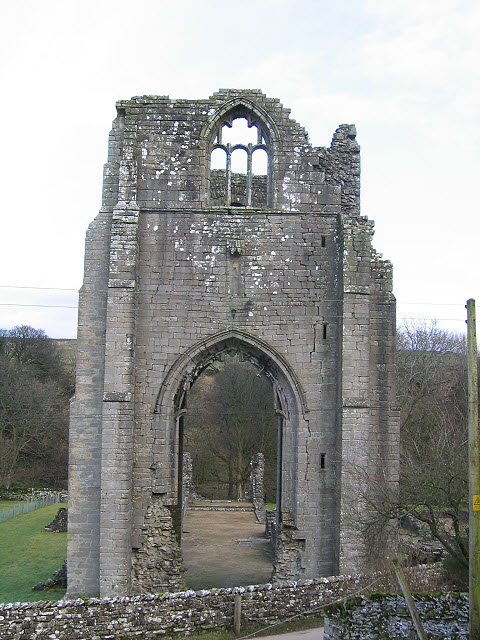
Shap Abbey (ruins)
- Overview About Shap Abbey Map Street View Shap Abbey is located about 1½ miles west of the village of Shap in Cumbria. The Abbey was founded in c.1200 by local …
Co-Curate Page
Casterton Stone Circle
- Overview Map An embanked circle of 17 relatively small stones, probably dating from the Bronze Age. The stone circle is located near Langthwaite Gill Plantation and about 1 mile east …
Co-Curate Page
King Arthur's Round Table Henge
- Overview About King Arthur's Round Table Map Street View King Arthur's Round Table Henge is located at the south of the village of Eamont Bridge in Cumbria. It is thought …
Co-Curate Page
Roman milestone near Spitals Farm
- There is Roman milestone near Spitals Farm, on the side of the old A66 road between the villages of Kirkby Thore and Temple Sowerby in Cumbria. The milestone, carved from red …
Co-Curate Page
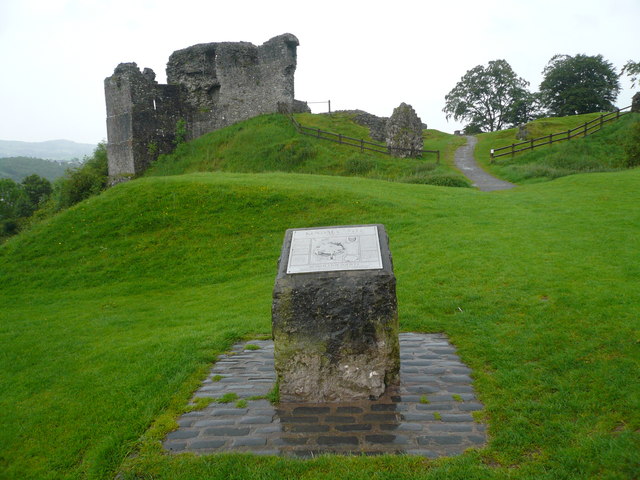
Castle Howe motte and bailey castle
- Overview Map Street View The remains of Castle Howe, a motte and bailey castle, is located by the confluence of Birk Beck with the River Lune, to the west of …
Co-Curate Page
Rotherhope Fell Mine
- Overview Map (area 1) Map (area 2) "...The monument, which is divided into two areas, is situated on the north east side of Rotherhope Fell above Black Burn. It includes …

Co-Curate Page
Waitby
- Overview About waitby Map Street View Waitby is a small village in the Eden district of Cumbria, located just over a mile west of Kirkby Stephen and 2 miles south-east …
Co-Curate Page
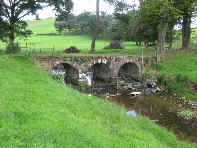
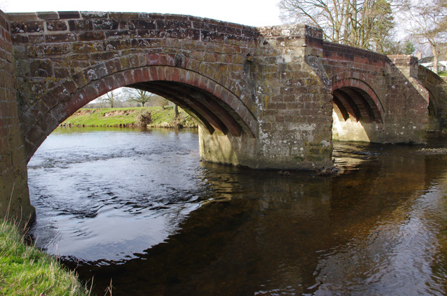
Bow Bridge, near Furness Abbey
- Overview Map Street View Bow Bridge is a 15th Century multi-span bridge over Mill Beck, located about ¼ mile south east of Furness Abbey. It was built by the monks …
Co-Curate Page
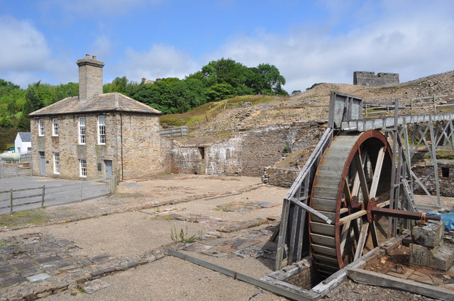
Nenthead Mines
- Overview Map Street View "Nenthead Mines is a historic place at Nenthead, near Alston, in Cumbria, UK. This remote valley is covered by remains from the lead and zinc mining …
Co-Curate Page
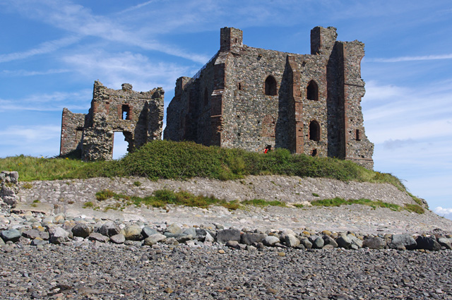
Piel Castle
- Overview About Piel Castle Map Street View Piel Castle, also known as Fouldry Castle or the Pile of Fouldray, is a castle situated on the south-eastern point of Piel …
Co-Curate Page
Kendal Castle
- Overview About Kendal Castle Map Street View The ruins of Kendal Castle are located on the east side of the River Kent on Castle Hill (a large glacial moraine), overlooking …

Co-Curate Page
Bewley Castle (ruins)
- Bewley Castle, now in ruins, was once the residence of Bishops of Carlisle. The original castle here ('Bellus Locus') is thought to have been built by Bishop Hugh who died in …
Co-Curate Page
Medieval moated site, Kirkoswald
- Scheduled Monument area - map data from Historic England c/o Open Data UK, under the Open Government Licence, imported into Google MyMaps, March 2026. This Medieval moated site is located …

Co-Curate Page
Birkrigg Stone Circle
- Overview About Birkrigg Stone Circle Map Street View Birkrigg Stone Circle (also known as the Druid's Circle) is located on Birkrigg Common in Cumbria, located about 2 miles south of …
Co-Curate Page
Myers Head Lead Mine
- The remains of Myers Head Lead Mine are located by the confluence of Pasture Beck and Hayeswater Gill, south-east of Hartsop in the Eden district of Cumbria.
Co-Curate Page
Arnside Tower
- Overview About Arnside Tower Map Street View Arnside Tower is a late-medieval tower house located about half a mile south of the village of Arnside and a similar distance north-east …
Co-Curate Page
Long Meg and Her Daughters (stone circle)
- Overview About Long Meg and Her Daughters Map Street View Long Meg and Her Daughters is a stone circle in Cumbria, located about half a mile north-east of the village …
Co-Curate Page
Kirkoswald Castle
- Overview About Kirkoswald Castle Map Street View The ruins of Kirkoswald Castle are located to the south-east of Kirkoswald in Cumbria. A licence to crenellate (fortify) an existing building was granted …
Co-Curate Page
Backbarrow Ironworks
- Established in 1711. Isaac Wilkinson worked here, he developed a furnace fuelled by charcoal and was one of the first of its kind in the UK.The main products of the …
Co-Curate Page
Croglam Castle (Iron Age site)
- Overview Map This is a Scheduled Monument at the south-west of Kirkby Stephen. It includes the earthwork and buried remains of a defended settlement of Iron Age date, situated on …
Co-Curate Page
Mayburgh Henge
- Overview About Mayburgh Henge Map Street View Henges are ritual or ceremonial sites which date to the Late Neolithic period (2800-2000 BC). Mayburgh Henge is located close to the confluence …
Co-Curate Page
Brougham Castle
- Overview About Brougham Castle Map Street View Located about a mile south-east of Penrith in Cumbria. Brougham Castle (pronounced /ˈbruːm/) is a medieval building about 2 miles (3.2 km) south-east …
Co-Curate Page
Low Wood Gunpowder Works
- Overview About Low Wood Gunpowder Works Map Street View The Low Wood Gunpowder Works, located on the east banks of the River Leven at Low Wood, were in operation from …
Co-Curate Page
Addingham Cross
- The 'Addingham Cross' is a late 10th or early 11th century Saxon stone cross in the churchyard of St Michael's Church, Glassonby. The cross was originally located in the churchyard …
Co-Curate Page
Shap Abbey (ruins)
- Overview About Shap Abbey Map Street View Shap Abbey is located about 1½ miles west of the village of Shap in Cumbria. The Abbey was founded in c.1200 by local …
Co-Curate Page
Casterton Stone Circle
- Overview Map An embanked circle of 17 relatively small stones, probably dating from the Bronze Age. The stone circle is located near Langthwaite Gill Plantation and about 1 mile east …
Co-Curate Page
King Arthur's Round Table Henge
- Overview About King Arthur's Round Table Map Street View King Arthur's Round Table Henge is located at the south of the village of Eamont Bridge in Cumbria. It is thought …
Co-Curate Page
Roman milestone near Spitals Farm
- There is Roman milestone near Spitals Farm, on the side of the old A66 road between the villages of Kirkby Thore and Temple Sowerby in Cumbria. The milestone, carved from red …
Co-Curate Page
Castle Howe motte and bailey castle
- Overview Map Street View The remains of Castle Howe, a motte and bailey castle, is located by the confluence of Birk Beck with the River Lune, to the west of …
Co-Curate Page
Rotherhope Fell Mine
- Overview Map (area 1) Map (area 2) "...The monument, which is divided into two areas, is situated on the north east side of Rotherhope Fell above Black Burn. It includes …
Co-Curate Page
Waitby
- Overview About waitby Map Street View Waitby is a small village in the Eden district of Cumbria, located just over a mile west of Kirkby Stephen and 2 miles south-east …
Co-Curate Page
Bow Bridge, near Furness Abbey
- Overview Map Street View Bow Bridge is a 15th Century multi-span bridge over Mill Beck, located about ¼ mile south east of Furness Abbey. It was built by the monks …
Co-Curate Page
Nenthead Mines
- Overview Map Street View "Nenthead Mines is a historic place at Nenthead, near Alston, in Cumbria, UK. This remote valley is covered by remains from the lead and zinc mining …
Co-Curate Page
Piel Castle
- Overview About Piel Castle Map Street View Piel Castle, also known as Fouldry Castle or the Pile of Fouldray, is a castle situated on the south-eastern point of Piel …
Co-Curate Page
Kendal Castle
- Overview About Kendal Castle Map Street View The ruins of Kendal Castle are located on the east side of the River Kent on Castle Hill (a large glacial moraine), overlooking …
Co-Curate Page
Bewley Castle (ruins)
- Bewley Castle, now in ruins, was once the residence of Bishops of Carlisle. The original castle here ('Bellus Locus') is thought to have been built by Bishop Hugh who died in …


