Topics > County Durham > Civil Parishes in County Durham > Stanley Town Council Area > Historic Buildings and Monuments in Stanley
Historic Buildings and Monuments in Stanley
Listed buildings and scheduled monuments in Stanley Civil Parish, County Durham, from the National Heritage List for England[1]. Use the Search (below) if looking for a specific building / monument.
| Structure | List No. | Grade | Built~ | Notes |
|---|---|---|---|---|
| Beamish Burn Farmhouse | 1240811 | II | C18th | Beamish |
| Beamish Hall | 1260862 | II* | C16th | Beamish |
| Beamish Home Farm House, Stable and Mounting Block | 1260821 | II | C18th | Beamish |
| Beamishburn Bridge | 1260823 | II | C18th | Beamish |
| Beckley Farmhouse and Farmbuildings Attached | 1260744 | II | C18th | Beckley, near Tanfield |
| Causey Arch | 1240816 | I | 1726 | Causey, near Tanfield |
| Christ Church Non-Conformist Church | 1391865 | II | 1895 | Stanley |
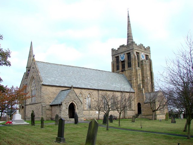
| Church of St Andrew | 1323689 | II | 1876 | Stanley |
| Church of St George | 1260778 | II | 1897 | South Moor |
| Church of St Margaret | 1240887 | II | 1749 | Tanfield |
| Church of St Thomas | 1240951 | II | 1841 | Harelaw, Annfield Plain |
| Cock Grave Cover Adjacent to West Wall of South Side of Church of St Margaret | 1240888 | II | 1636 | Tanfield |
| Culvert, Arch and Retaining Walls, in West Face of Embankment over Causey Burn | 1260837 | I | 1717 | Causey |
| Davison Tomb Adjacent to East Wall of South Side of Nave of Church of St Margaret | 1240889 | II | 1811 | Tanfield |
| Derwentside Area Council Offices | 1260825 | II | 1911 | Stanley. Front Street |
| Farm Buildings at Beamish Hall Farm | 1240809 | II | C18th | Beamish |
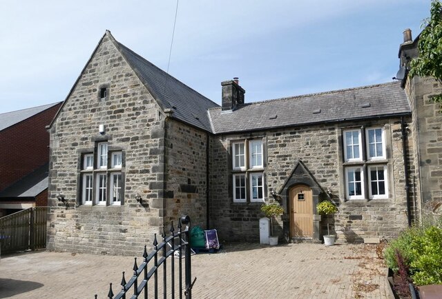
| Former Collierley National School | 1406014 | II | 1846 | Harelaw |
| Former Miner's Hall and Institute | 1260777 | II | 1898 | South Moor |
| Fountain About 100 Metres East of Beamish Hall Gardens | 1240800 | II | C19th | Beamish Hall |
| Garden Wall, Piers, Gates, and House Attached at Beamish Hall Gardens | 1240739 | II* | C18th | Beamish Hall |
| Gate Piers West of Church of St Margaret | 1260765 | II | C18th | Tanfield |
| Grey Tomb Circa 10 Metres South West of Church of St Margaret | 1260785 | II | 1771 | Tanfield |
| Harelaw Watering Place | 1240896 | II | C17th | Harelaw. Spring head. |
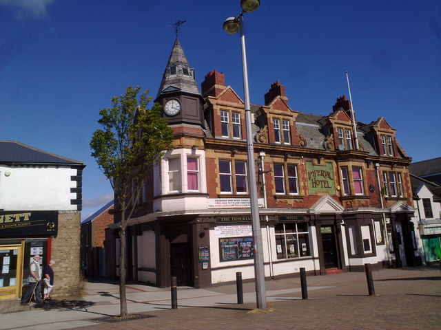
| Imperial Hotel | 1240819 | II | 1911 | Stanley. Front Street |
| Joicey Tomb Circa 20 Metres North East of Gates to Church of St Margaret | 1240891 | II | 1863 | Tanfield |
| Memorial Opposite Number 12 Loud Terrace | 1240732 | II | c.1918 | Annfield Plain |
| Middles Farmhouse | 1240895 | II | C18th | South Stanley |
| Pillar Box Approx. 87 Metres East-South-East of Bandstand | 1240810 | II | 1870s | Beamish |
| Public Library | 1240952 | II | 1908 | Annfield Plain |
| Roman Catholic Church of St Joseph | 1391984 | II | 1902 | Stanley |
| Rosedale Manor | 1240898 | II | c1840 | Harelaw |
| St Margarets House | 1260781 | II | C18th | Tanfield |
| Stables North of Beamish Hall | 1260855 | II | C19th | Beamish Hall |
| Stables to Rear of Number 40 | 1260782 | II | C19th | Tanfield, back of Front Street |
| Stanley War Memorial | 1440528 | II | 1923 | Stanley. By St Andrew's Church |
| Starling Bridge over Beamish Burn | 1240808 | II | C19th | Beamish |
| Sundial on Lawn to East of Beamish Hall | 1240740 | II | C17th | Beamish Hall |
| Tanfield Hall | 1240892 | II* | C17th | Tanfield |
| The Gatehouse | 1240886 | II | C18th | Tanfield. Front Street |
| Turnbull Tomb Circa 10 Metres South East of Church of St Margaret | 1240890 | II | 1786 | Tanfield |
| Wall, Trough and Horse Wash South of Beamish Home Farm | 1260822 | II | C19th | Beamish |
| Walls and Garage Around Garden of Rosedale Manor | 1260776 | II | c1840 | Harelaw |
| Walls and Gate Piers South of Church of St Margaret | 1260786 | II | C18th | Tanfield |
| Walls, Piers, Steps, Gates and Railings in Front of Tanfield Hall | 1260787 | I | c.1730 | Tanfield |
| War Memorial | 1240796 | II | c.1919 | Greencroft. South Pontop Colliery WW1 |
| War Memorial | 1240817 | II | 1922 | Craghead |
| War Memorial in Annfield Plain Park | 1240857 | II | 1919 | Annfield Plain |
| War memorial outside St George's Church, South Moor | 1440397 | II | 1919 | South Moor |
| West Lodge | 1240812 | II | c1860 | Former lodge to Beamish Hall |
| Wonders Tomb Circa 20 Metres South of Church of St Margaret | 1260762 | II | 1731 | Tanfield |
| Wray Tomb Circa 6 Metres South East of Church of St Margaret | 1260784 | II | 1678 | Tanfield |
| Causey Arch, Tanfield | 1002364 | n/a | 1726 | Scheduled Monument |
| Bobgins engine house 250m south west of New House, Causey | 1018225 | n/a | C18th | Scheduled Monument |
Primary source: the National Heritage List for England - NHLE is the register of nationally protected historic buildings and sites in England, including listed buildings, scheduled monuments, protected wrecks, registered parks and gardens, and battlefields. The list is maintained by Historic England. Check NHLE for updates and new entries. Secondary sources: British Listed Buildings and Keys to the Past.
Co-Curate Page
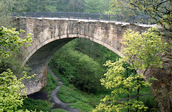
Causey Arch
- Overview History Map Causey Arch bridge near Tanfield was built by the Grand Allies in 1726 and is renowned to be the world's oldest surviving single-arch railway bridge. Horse-drawn wagons …
Co-Curate Page
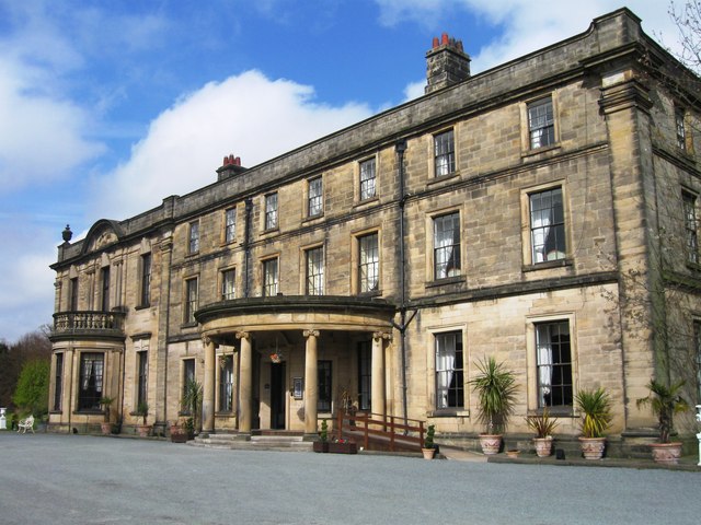
Beamish Hall
- Overview History of Beamish Hall Map Street View Beamish Hall Hotel is located near Beamish village and Beamish Museum in County Durham. It has a core dating from the late …
Co-Curate Page
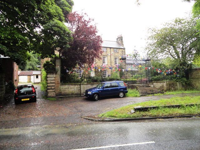
Tanfield Hall
- Overview Map Street View Tanfield Hall is a private dwelling on Front Street in Tanfield, County Durham. The three storey Hall is a Grade II* Listed building on the National …
Co-Curate Page
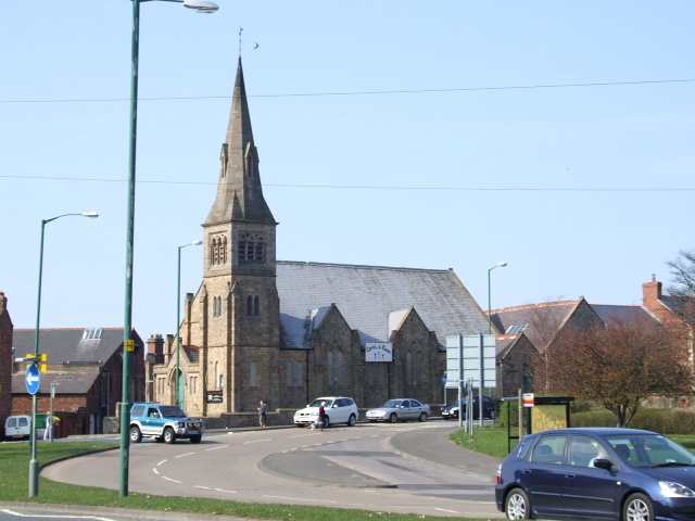
Church of St Andrew, Stanley
- Overview Map Street View St Andrew's Church is located on Church Bank / Joicey Gardens in Stanley, County Durham. The church was built 1876 - 1877, and designed by J. …
Co-Curate Page
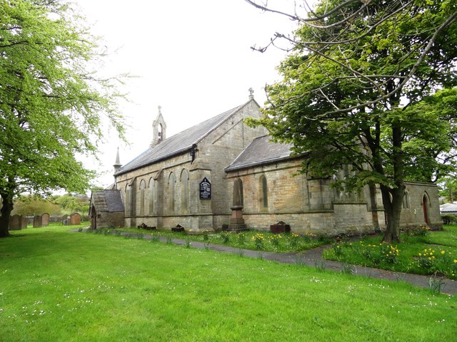
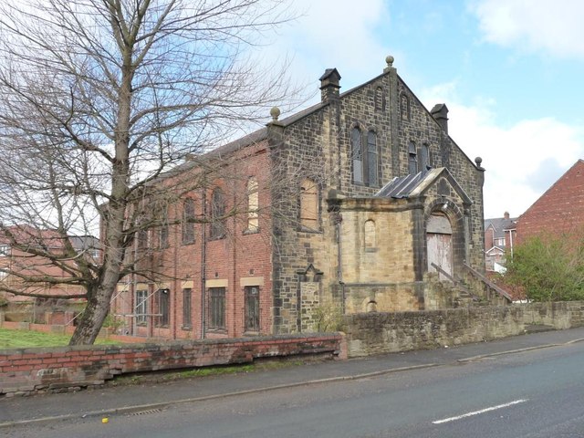
Christ Church, Stanley
- Overview Map Street View Christ Church is located on Church Bank / Station Road in Stanley, County Durham. It was built in 1895, originally as a Presbyterian Church, now United …
Co-Curate Page
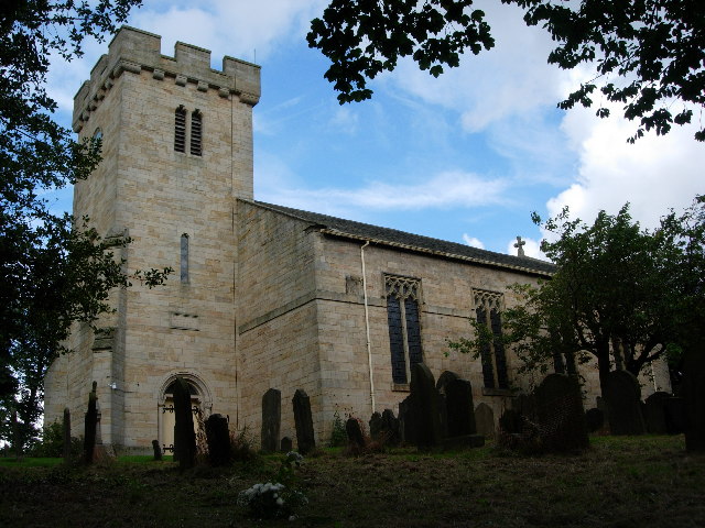
Church of St Margaret of Antioch, Tanfield
- Overview Map Street View "Little is known for certain about the 'early' days of St Margaret's Church, but it is generally believed that St Cuthbert's monks chose Tanfield to hide …
Co-Curate Page
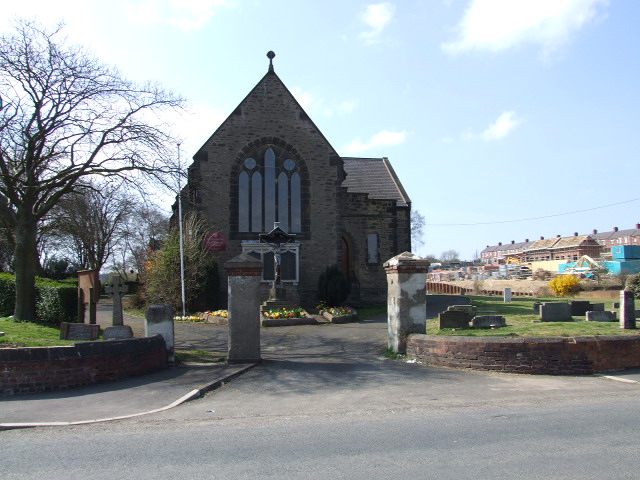
Church of St Thomas, Harelaw
- Overview Map Street View St. Thomas' Church is located on North Road, Harelaw, Annfield Plain. The church, by G. Jackson, was built in 1841 at a time when the population …
Co-Curate Page
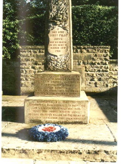
Loud Hill Memorial
- Overview Map Street View This memorial in Annfield Plain is inscribed "It was here that Pilot Officer Joyce met his death on the night of March 13 1918." The memorial …
Co-Curate Page
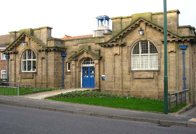
Annfield Plain Library
- Overview Map Street View The library in Annfield Plain was built in 1908. The land for the library was donated by John Wilkinson Taylor, M.P., and the building itself was …
Co-Curate Page
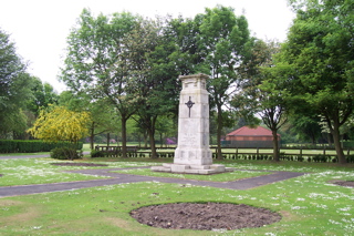
War Memorial
- The war memorial is located in Annifield Plain Park. It is inscribed with the names of the 263 men of Annifield Plain lost in the First World War and the …

Co-Curate Page
War Memorial, Craghead
- Overview Map Street View The War Memorial in Craghead is located off Edward Street. The statue of an angel was unveiled on the 11th November 1922 by R.W. Cooper, Managing …
Co-Curate Page
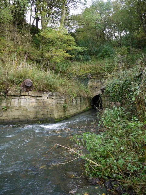
Causey Burn Culvert
- Overview Map This 80m long culvert, arch, embankment and retaining walls were built in 1717 to carry Tanfield wagonway over Causey Burn. It is said to be the first railway …
Co-Curate Page
Gates and railings, Tanfield Hall
- Overview Map Street View The walls, piers, steps, gates and railings in front of Tanfield Hall date from c.1730. They are Grade I listed on the National Heritage List for …
Co-Curate Page
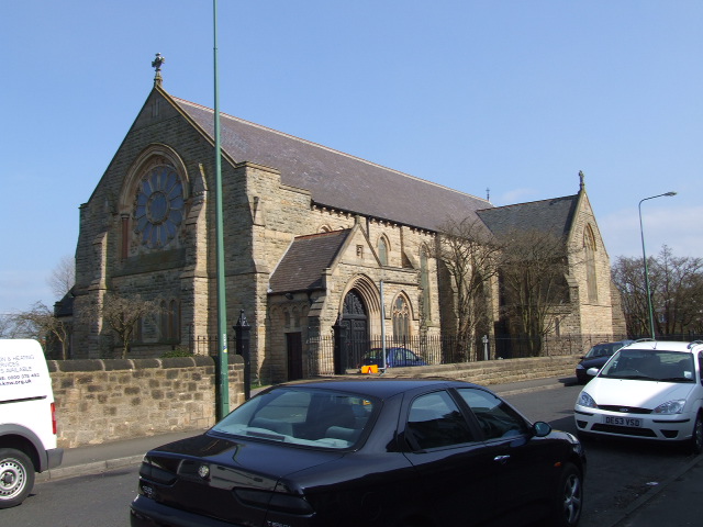
Church of St George, South Moor
- Overview Map Street View St George's Church is located on South Moor Road in South Moor, County Durham. The Parish church was built in 1897 by J.W. Thompson. The church is a …
Co-Curate Page
Former Miner's Hall and Institute, South Moor
- Overview Map Street View This former Miner's Hall and Institute on South Moor Road in South Moor, was built in 1898. For a time the building was used as the …
Co-Curate Page
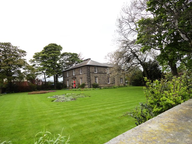
Rosedale Manor, Harelaw
- Overview Map Street View Rosedale Manor is located on North Road by the junction with Harelaw Gardens, in Harelaw. It is a former vicarage built in c1840, now a private …
Co-Curate Page
RC Church of St Joseph, Stanley
- Overview Map Street View St Joseph's Roman Catholic Church is located on Thorneyholme Terrace in Stanley. The church was built from 1898-1902, designed by Charles Walker in Gothic Revival style. …
Co-Curate Page
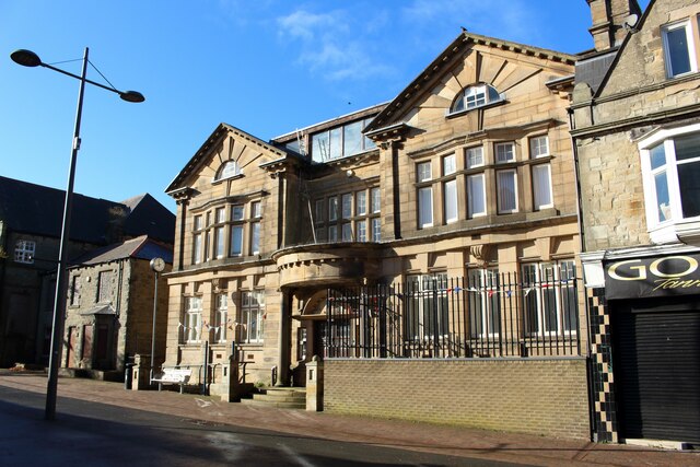
Former Derwentside Area Council Offices
- Overview Map The former Derwentside Area Council Offices building is located on Front Street in Stanley. The building is dated 1910 (date above the entrance) and was designed by J.W. …
Co-Curate Page
Imperial Hotel, Stanley
- Overview Map The Imperial Hotel on Front Street in Stanley was built in 1905. The Baroque style building has a wood corner turret with a clock (the building is locally known …
Co-Curate Page
Old Collierley National School, Harelaw
- Overview Map Street View The former Collierley national school and schoolmasters' house in Harelaw is located on North Road (B6168). The Collierley national school was built in 1846, to the …


Co-Curate Page
Causey Arch
- Overview History Map Causey Arch bridge near Tanfield was built by the Grand Allies in 1726 and is renowned to be the world's oldest surviving single-arch railway bridge. Horse-drawn wagons …
Co-Curate Page
Beamish Hall
- Overview History of Beamish Hall Map Street View Beamish Hall Hotel is located near Beamish village and Beamish Museum in County Durham. It has a core dating from the late …
Co-Curate Page
Tanfield Hall
- Overview Map Street View Tanfield Hall is a private dwelling on Front Street in Tanfield, County Durham. The three storey Hall is a Grade II* Listed building on the National …
Co-Curate Page
Church of St Andrew, Stanley
- Overview Map Street View St Andrew's Church is located on Church Bank / Joicey Gardens in Stanley, County Durham. The church was built 1876 - 1877, and designed by J. …
Co-Curate Page
Christ Church, Stanley
- Overview Map Street View Christ Church is located on Church Bank / Station Road in Stanley, County Durham. It was built in 1895, originally as a Presbyterian Church, now United …
Co-Curate Page
Church of St Margaret of Antioch, Tanfield
- Overview Map Street View "Little is known for certain about the 'early' days of St Margaret's Church, but it is generally believed that St Cuthbert's monks chose Tanfield to hide …
Co-Curate Page
Church of St Thomas, Harelaw
- Overview Map Street View St. Thomas' Church is located on North Road, Harelaw, Annfield Plain. The church, by G. Jackson, was built in 1841 at a time when the population …
Co-Curate Page
Loud Hill Memorial
- Overview Map Street View This memorial in Annfield Plain is inscribed "It was here that Pilot Officer Joyce met his death on the night of March 13 1918." The memorial …
Co-Curate Page
Annfield Plain Library
- Overview Map Street View The library in Annfield Plain was built in 1908. The land for the library was donated by John Wilkinson Taylor, M.P., and the building itself was …
Co-Curate Page
War Memorial
- The war memorial is located in Annifield Plain Park. It is inscribed with the names of the 263 men of Annifield Plain lost in the First World War and the …
Co-Curate Page
War Memorial, Craghead
- Overview Map Street View The War Memorial in Craghead is located off Edward Street. The statue of an angel was unveiled on the 11th November 1922 by R.W. Cooper, Managing …
Co-Curate Page
Causey Burn Culvert
- Overview Map This 80m long culvert, arch, embankment and retaining walls were built in 1717 to carry Tanfield wagonway over Causey Burn. It is said to be the first railway …
Co-Curate Page
Gates and railings, Tanfield Hall
- Overview Map Street View The walls, piers, steps, gates and railings in front of Tanfield Hall date from c.1730. They are Grade I listed on the National Heritage List for …
Co-Curate Page
Church of St George, South Moor
- Overview Map Street View St George's Church is located on South Moor Road in South Moor, County Durham. The Parish church was built in 1897 by J.W. Thompson. The church is a …
Co-Curate Page
Former Miner's Hall and Institute, South Moor
- Overview Map Street View This former Miner's Hall and Institute on South Moor Road in South Moor, was built in 1898. For a time the building was used as the …
Co-Curate Page
Rosedale Manor, Harelaw
- Overview Map Street View Rosedale Manor is located on North Road by the junction with Harelaw Gardens, in Harelaw. It is a former vicarage built in c1840, now a private …
Co-Curate Page
RC Church of St Joseph, Stanley
- Overview Map Street View St Joseph's Roman Catholic Church is located on Thorneyholme Terrace in Stanley. The church was built from 1898-1902, designed by Charles Walker in Gothic Revival style. …
Co-Curate Page
Former Derwentside Area Council Offices
- Overview Map The former Derwentside Area Council Offices building is located on Front Street in Stanley. The building is dated 1910 (date above the entrance) and was designed by J.W. …
Co-Curate Page
Imperial Hotel, Stanley
- Overview Map The Imperial Hotel on Front Street in Stanley was built in 1905. The Baroque style building has a wood corner turret with a clock (the building is locally known …


