Topics > Northumberland > Civil Parishes in Northumberland > Acklington Civil Parish > Historic Buildings in Acklington Civil Parish
Historic Buildings in Acklington Civil Parish
Listed buildings and scheduled monuments in Acklington Civil Parish, Northumberland, from the National Heritage List for England[1]. Use the Search (below) if looking for a specific building / monument.
| Structure | List No. | Grade | Built~ | Note |
|---|---|---|---|---|
| Nos. 1 2 and 4, Guyzance Village | 1153753 | II | ||
| No. 6, Guyzance Village | 1371132 | II | ||
| Nos. 7 and 8, Guyzance Village | 1041889 | II | ||
| Acklington Church of England Controlled First School | 1041915 | II | 1853 | Former school (closed 2018). |
| Acklington Station | 1371112 | II | 1847 | |
| Brainshaugh (house) | 1153504 | II* | C16th | Brainshaugh |
| Bridge over Quarry Burn on Hall Drive 40 Metres East of West Lodge | 1041928 | II | ||
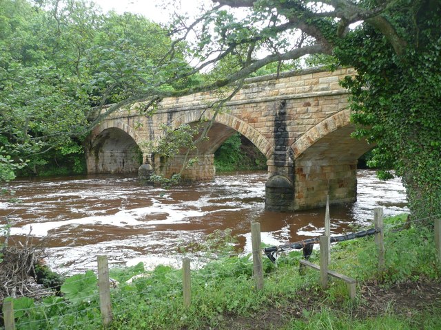
| Bridge over River Coquet (factory Bridge) | 1041925 | II | 1865 | Brainshaugh |
| British Rail East Coast Main Line Viaduct | 1155436 | II | ||
| Cartshed Granary at Bank House Farm with Attached Cottages to East | 1041920 | II | ||
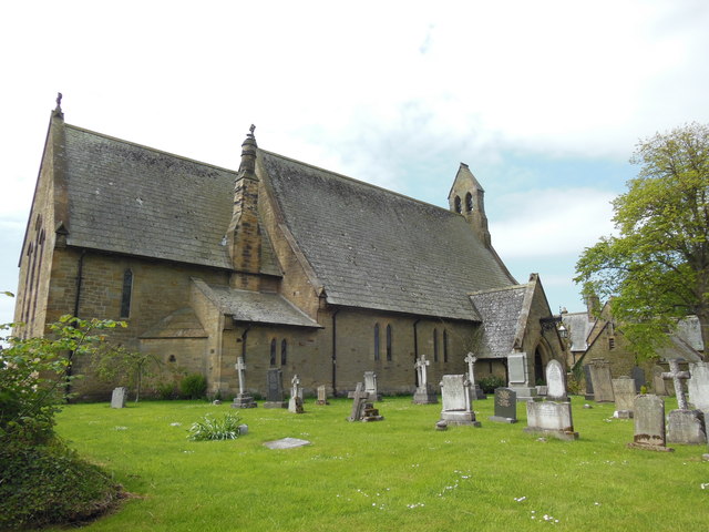
| Church of St John the Divine | 1371111 | II | 1860 | Acklington |
| Dairy at Bank House Farm to South East of Main Farmbuilding Complex | 1041921 | II | ||
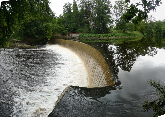
| Dam on River Coquet 350 Metres Upstream of Guyzance Bridge | 1153600 | II | 1775 | Acklington Park |
| Former Goods Shed to West of Acklington Station | 1304321 | II | ||
| Game larder and walls to north and east of tennis court | 1371114 | II | ||
| Garden Wall and Gate to North West of Hall | 1153680 | II | ||
| Garden Walls to South East of Brainshaugh with Attached Privy | 1041922 | II | ||
| Garden Walls to South of Hall | 1041927 | II | ||
| Gatepiers and Quadrant Walls to the Old Vicarage | 1041918 | II | ||
| Graveyard Wall Adjacent to Ruined Church or Chapel | 1041923 | II | ||
| Guyzance Hall and East Wing Cottage | 1304198 | II | c.1800 | Guyzance. House, significantly extended in 1892 |
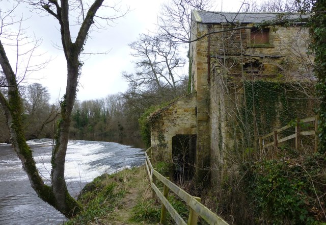
| Guyzance Mill | 1041924 | II | 1830s | Guyzance |
| Loose Box at Bank House Farm | 1153493 | II | ||
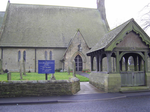
| Lych Gate to Church of St. John the Divine | 1041919 | II | 1921 | Acklington. War memorial. |
| Mill House with Barn to South | 1153584 | II | ||
| Number 18 and Adjacent Old Smithy | 1371108 | II | ||
| Number 5 and Former Joiners Shop on West | 1371131 | II | ||
| Outbuilding Group to South of Numbers 7 and 8 | 1041890 | II | ||
| Outbuilding to North of Old Vicarage with Attached Yard Walls | 1041917 | II | ||
| Outbuilding to South of East Wing Cottage | 1371113 | II | ||
| Pant Opposite Old Vicarage | 1041916 | II | C19th | Acklington |
| Pump Opposite Number 1 | 1041891 | II | ||
| Roadside Walls on North Side of Street | 1041888 | II | ||
| Roadside Walls on South of Street | 1371133 | II | ||
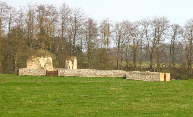
| Ruins of Church or Chapel (Brainshaugh Priory) | 1153531 | II* | C12th | Brainshaugh Scheduled Monument(1006579) |
| School House | 1371109 | II | ||
| The Dye House | 1041926 | II | 1776 | Acklington Park |
| The Old School | 1371115 | II | ||
| The Old Vicarage | 1371110 | II | ||
| Walls South East of Hall Attached Summerhouse and Gatehouse | 1153717 | II | ||
| West Lodge | 1304167 | II | ||
| Guyzance Conservation Area | - | n/a | Conservation Area | |
| Guyzance (or Brainshaugh) Chapel near Acklington | 1006579 | n/a | Scheduled Area |
Primary source: the National Heritage List for England - NHLE is the register of nationally protected historic buildings and sites in England, including listed buildings, scheduled monuments, protected wrecks, registered parks and gardens, and battlefields. The list is maintained by Historic England. Check NHLE for updates and new entries. Secondary sources: British Listed Buildings and Keys to the Past.
Co-Curate Page
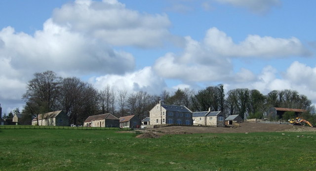
Brainshaugh
- Overview Map Street View Brainshaugh is a hamlet located by the River Coquet, about half a mile south-west of Guyzance, in Northumberland. It takes its name from Brainshaugh, a 16/17th …
Co-Curate Page
Dam on the River Coquet
- Overview Map This horseshoe-shaped dam on the River Coquet was built in 1775 to provide water power for Park Mill ironworks. The mill and dam were designed by John Smeaton …
Co-Curate Page
Factory Bridge over River Coquet
- Overview Map Street View This road bridge over the River Coquet was built in c.1865. It is known as Factory Bridge, presumably for the close proximity to the former mill/factory …
Co-Curate Page
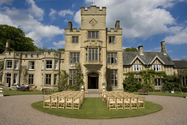
Guyzance Hall
- Overview Map Guyzance Hall is located by the River Coquet, to the south-east of the village of Guyzance in Northumberland. In 1892, J.D. Milburn, who was an industrial entrepreneur and ship …
Co-Curate Page
Brainshaugh Priory
- Overview Map Street View The priory ruins are located by a tight bend in the River Coquet at Brainshaugh, near Guyzance, in Northumberland. It was originally St Wilfrid's Premonstratensian nunnery, founded …
Co-Curate Page
Church of St John The Divine
- Overview Map Street View The Parish Church of St John the Divine in Acklington was built in 1860. It was designed by James Deason, for the Duke of Northumberland. The …
Co-Curate Page
Lych Gate, St John's Church
- Overview Map Street View The oak framed lych gate to St John the Divine's Church in Ackington was built to commemorate those in the parish who were lost in the …
Co-Curate Page
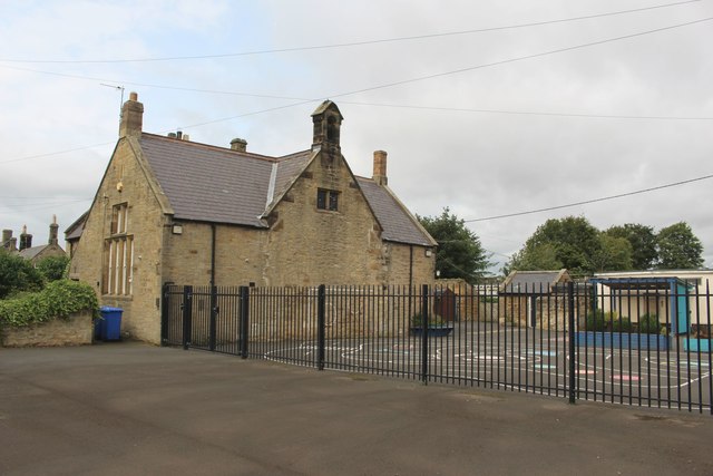
Acklington First School (1853 - 2018)
- Overview Map Street View A National School was established in Acklington in 1853. This went on to be Acklington Church of England First School. The school was closed on the …
Co-Curate Page
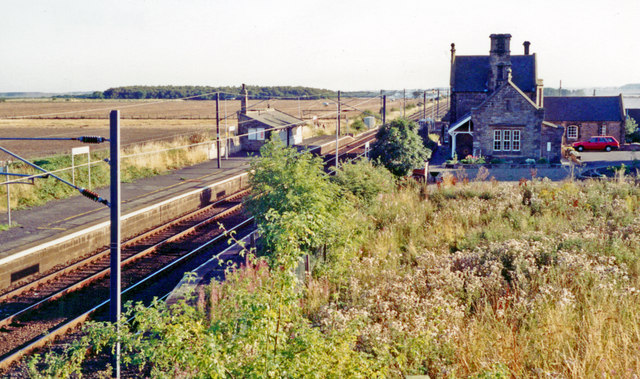
Acklington Station
- Overview About Acklington Station Map Street View The railway station in Acklington is on the East Coast Main Line, situated between the stations at Widdrington and Alnmouth. The station, located …
Co-Curate Page
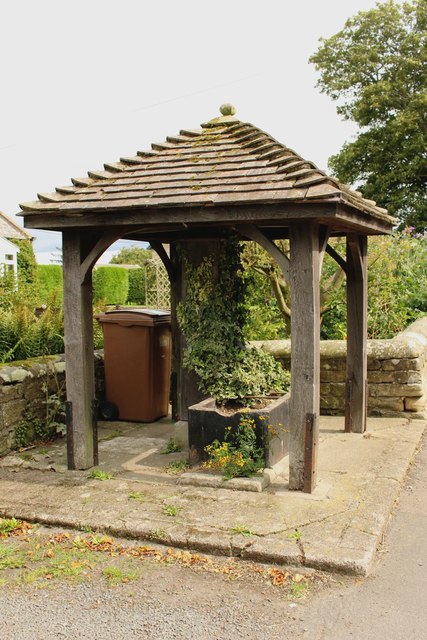
Pant, Main Street
- Overview Map Street View There is a 19th century pant (pump and trough) under a canopy in Acklington on Main Street, opposite the Old Vicarage. The pant is Grade II …
Co-Curate Page
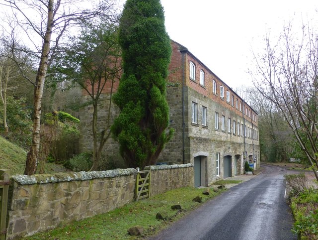
The Dye House, Acklington Park
- Overview Map Street View Dye House is a residential building on the south banks of the River Coquet in Acklington Park, about a mile south of Guyzance. It was originally …

Co-Curate Page
Brainshaugh
- Overview Map Street View Brainshaugh is a hamlet located by the River Coquet, about half a mile south-west of Guyzance, in Northumberland. It takes its name from Brainshaugh, a 16/17th …
Co-Curate Page
Dam on the River Coquet
- Overview Map This horseshoe-shaped dam on the River Coquet was built in 1775 to provide water power for Park Mill ironworks. The mill and dam were designed by John Smeaton …
Co-Curate Page
Factory Bridge over River Coquet
- Overview Map Street View This road bridge over the River Coquet was built in c.1865. It is known as Factory Bridge, presumably for the close proximity to the former mill/factory …
Co-Curate Page
Guyzance Hall
- Overview Map Guyzance Hall is located by the River Coquet, to the south-east of the village of Guyzance in Northumberland. In 1892, J.D. Milburn, who was an industrial entrepreneur and ship …
Co-Curate Page
Brainshaugh Priory
- Overview Map Street View The priory ruins are located by a tight bend in the River Coquet at Brainshaugh, near Guyzance, in Northumberland. It was originally St Wilfrid's Premonstratensian nunnery, founded …
Co-Curate Page
Church of St John The Divine
- Overview Map Street View The Parish Church of St John the Divine in Acklington was built in 1860. It was designed by James Deason, for the Duke of Northumberland. The …
Co-Curate Page
Lych Gate, St John's Church
- Overview Map Street View The oak framed lych gate to St John the Divine's Church in Ackington was built to commemorate those in the parish who were lost in the …
Co-Curate Page
Acklington First School (1853 - 2018)
- Overview Map Street View A National School was established in Acklington in 1853. This went on to be Acklington Church of England First School. The school was closed on the …
Co-Curate Page
Acklington Station
- Overview About Acklington Station Map Street View The railway station in Acklington is on the East Coast Main Line, situated between the stations at Widdrington and Alnmouth. The station, located …
Co-Curate Page
Pant, Main Street
- Overview Map Street View There is a 19th century pant (pump and trough) under a canopy in Acklington on Main Street, opposite the Old Vicarage. The pant is Grade II …


