Topics > Civil Parishes in Cumbria > Stanwix Rural Civil Parish > Historic Buildings and Monuments in Stanwix Rural
Historic Buildings and Monuments in Stanwix Rural
Listed buildings and scheduled monuments in Stanwix Rural Civil Parish, Cumbria, from the National Heritage List for England[1]. In the absence of a published 'local list', some other public buildings of interest may also be included.Use the Search (below) if looking for a specific building / monument. Jump to Photos and more detailed information.
| Structure | List No. | Grade | Built~ | Note |
|---|---|---|---|---|
| Rickerby Park | 1448365 | II | c. 1835 | Listed Park and Garden |
| Hadrian's Wall between Tarraby and Beech Grove, Knowefield in wall miles 64 and 65 | 1017946 | n/a | Roman | Scheduled Monument. Hadrian's Wall |
| Hadrian's Wall and vallum between Birky Lane at Walby and the east side of the M6 in wall miles 62 and 63 | 1010980 | n/a | Roman | Scheduled Monument, Hadrian's Wall |
| Hadrian's Wall between the M6 motorway and the property boundaries to the east of Houghton Road in wall mile 64 | 1017942 | n/a | Roman | Scheduled Monument. Hadrian's Wall |
| Hadrian's Wall vallum between the M6 motorway and Drawdykes Castle in wall mile 64 | 1017943 | n/a | Roman | Scheduled Monument. Hadrian's Wall |
| Hadrian's Wall vallum between Drawdykes Castle and Whiteclosegate in wall mile 64 | 1017944 | n/a | Roman | Scheduled Monument. Hadrian's Wall |
| Hadrian's Wall between Houghton Road and Tarraby in wall mile 64 | 1017945 | n/a | Roman | Scheduled Monument. Hadrian's Wall |
| Moss Side 1 and 2 Roman temporary camps | 1010957 | n/a | Roman | Scheduled Monument |
| The Stanegate at Crosby Lodge | 1007158 | n/a | Roman | Scheduled Monument. Stanegate |
| A night dummy aerodrome control building, part of a World War II bombing decoy, 610m north east of Walby Cottage | 1020277 | n/a | 1942 | Scheduled Monument |
| Hadrian's Wall vallum between the boundaries north of the properties on Whiteclosegate and the field boundary west of Wall Knowe in wall miles 64 and 65 | 1017947 | n/a | Roman | Scheduled Monument. Hadrian's Wall |
| Hadrian's Wall and vallum between Baron's Dike and Birky Lane at Walby, in wall miles 60, 61 and 62. | 1010979 | n/a | Roman | Scheduled Monument. Hadrian's Wall |
| Barn View | 1087701 | II | C18th | Rickerby |
| Barns and Former Cottage, East of Brunstock Farm | 1107933 | II | C18th | Brunstock |
| Brunstock Cottage | 1335525 | II | 1830s | Brunstock |
| Brunstock Farmhouse and Barns | 1087725 | II | 1820s | Includes old dairy. |
| Brunstock House | 1087726 | II* | 1833 | Brunstock |
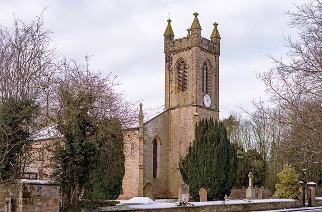
| Church of St John | 1119613 | II | 1854 | Low Crosby |
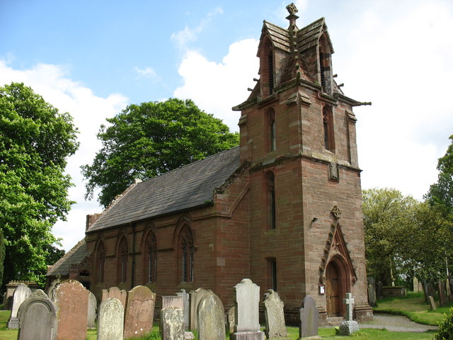
| Church of St John | 1119626 | II | 1842 | Houghton |
| Crosby House | 1323749 | II | C19th | High Crosby |
| Crosby Lodge | 1323750 | II | 1810 | High Crosby |
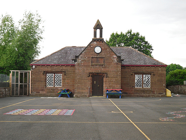
| Crosby on Eden School | 1335489 | II | 1844 | Low Crosby. Primary school. |
| Drawdykes Castle | 1087728 | II* | C14th | B6264. Tower, later converted to farmhouse. |
| East Lodge | 1107942 | II | 1833 | Brunstock |
| Eden Croft | 1119586 | II | ||
| Eden Croft Barn | 1432351 | II | ||
| Eden Grove | 1087696 | II | ||
| Rickerby House | 1335511 | II | 1835 | Rickerby. Former Eden School |
| Eden Steads | 1335490 | II | ||
| Fern Lea | 1087736 | II | ||
| Garden Wall South of High Crosby Farmhouse | 1335487 | II | ||
| Gate Piers to North of Crosby House | 1087731 | II | ||
| High Crosby Farmhouse | 1087729 | II | C18th | High Crosby |
| Houghton Hall | 1323770 | II | Houghton | |
| Houghton House | 1087734 | II | Houghton | |
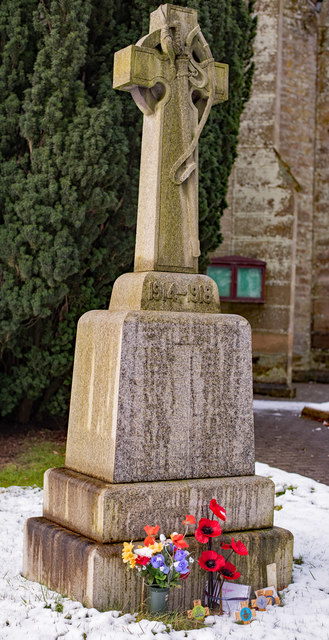
| Houghton War Memorial | 1457983 | II | 1922 | Houghton |
| Ivy Cottage | 1087699 | II | ||
| Knells House | 1087732 | II | ||
| Knells Lodge | 1087733 | II | ||
| Latchend and Cottage Adjoining | 1335524 | II | ||
| Linstock Castle | 1119608 | II* | C12th | Linstock. Tower house, now farmhouse. |
| Lodge at North East End of Brunstock Village | 1335523 | II | ||
| Lodge, East of Mill House | 1107887 | II | ||
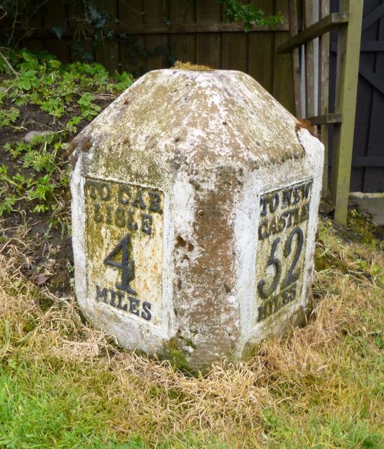
| Milestone (North East of Crosby House) | 1107876 | II | ||
| Milestone (North West of Oldgrove) | 1087697 | II | ||
| Milestone (South West of Drawdykes Castle) | 1323747 | II | ||
| Milestone to West of the Stag Inn | 1087738 | II | C18th | Low Crosby |
| Mill House | 1335486 | II | ||
| Moor House | 1087702 | II | ||
| Near Boot Inn | 1087704 | II | ||
| Oak House | 1335510 | II | ||
| Old Vicarage | 1119642 | II | ||
| Oldgrove | 1335507 | II | ||
| Roend | 1087724 | II | ||
| South Garth | 1087730 | II | ||
| Stable Block East of Eden School | 1323114 | II | ||
| Stables West of Eden Steads | 1335506 | II | ||
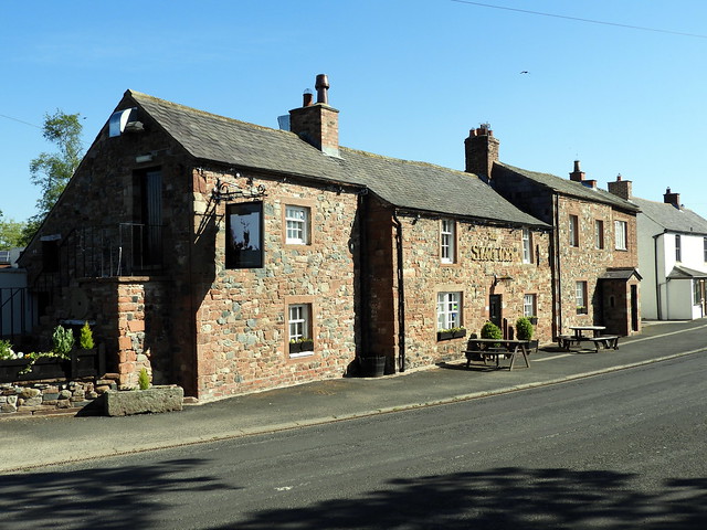
| Stag Inn | 1323767 | II | C17th | Low Crosby. With C20th extensions. |
| Study Quiet | 1087698 | II | ||
| Tarraby House and Barn | 1335512 | II | ||
| The Beeches | 1087703 | II | ||
| The Beeches | 1120930 | II | ||
| The Chestnuts | 1087723 | II | ||
| The Cottage | 1087700 | II | ||
| The Croft with Adjoining Stable and Barn and Byre Wing | 1087737 | II | ||
| The Grange | 1107923 | II | ||
| The Lodge | 1335488 | II | ||
| The Old Schoolhouse | 1335509 | II | ||
| The Thorn | 1120934 | II | ||
| Tower, North of Eden School (Rickerby Park Tower) | 1335508 | II | 1835 | Rickerby |
| Town Head Farmhouse | 1087735 | II | ||
| Walby Farmhouse | 1120935 | II | ||
| Walls, Gates and Gate Piers to Brunstock House | 1087727 | II | ||
| Walls, Railings, Gates and Gate Piers to West of Knells Lodge | 1119655 | II | ||
| West Lodge | 1325203 | II | ||
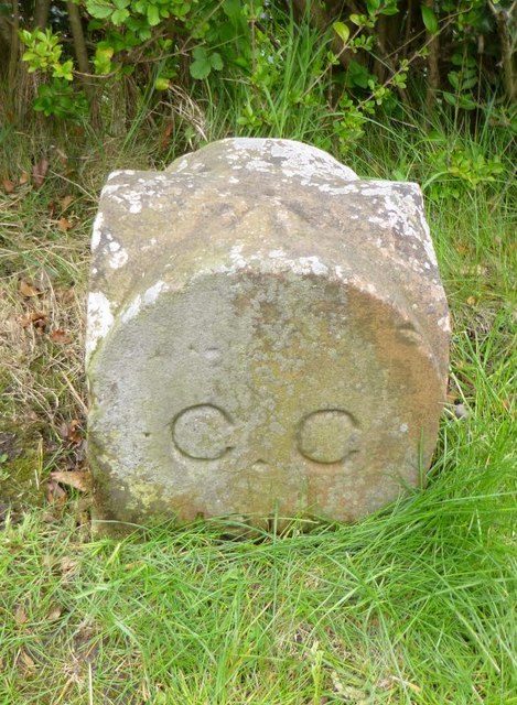
| Old Carlisle City Boundary Stone | not listed | n/a | 1912 | Whiteclosegate |
| Rickerby Conservation Area | - | n/a | Conservation Area | |
| Tarraby Conservation Area | - | n/a | Conservation Area |
Primary source: the National Heritage List for England - NHLE is the register of nationally protected historic buildings and sites in England, including listed buildings, scheduled monuments, protected wrecks, registered parks and gardens, and battlefields. The list is maintained by Historic England. Check NHLE for updates and new entries. Secondary sources: British Listed Buildings.
Co-Curate Page
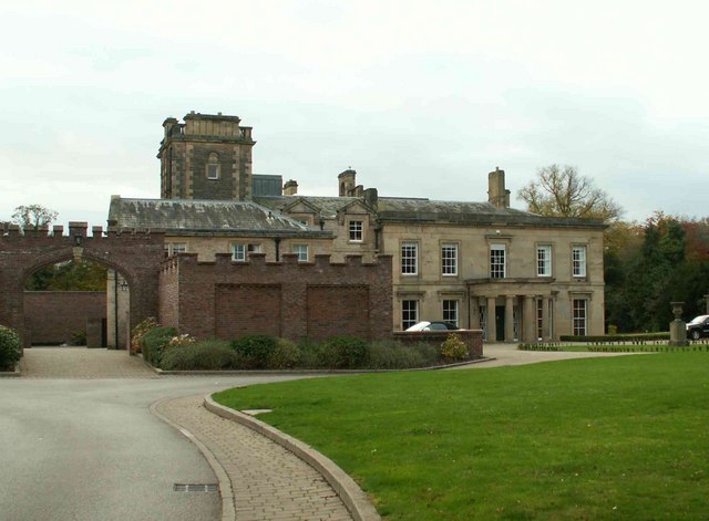
Rickerby House
- Overview Map Rickerby House was built c.1835 for George Head Head (c.1795 - 1876), banker, mine owner and High Sheriff of Cumberland. Landscaped gardens were laid out around the house. In …
Co-Curate Page
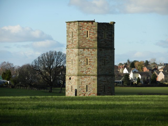
Rickerby Park Tower
- A folly, and possibly a dovecote built c.1835, for George Head Head, in the grounds of Rickerby House.[1] The tower is Grade II listed on the National Heritage List for …
Co-Curate Page
Linstock Castle
- Linstock Castle is a farmhouse in Linstock, Cumbria, originally built as a tower house in the 12th or early 13th century. The tower has large blocks of red sandstone, mostly …
Co-Curate Page
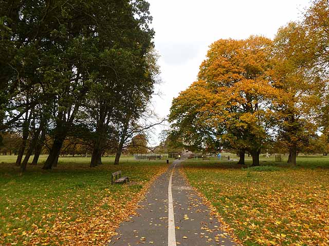
Rickerby Park
- Overview About Rickerby Park Map Street View Rickerby Park is a public open space in Carlisle, Cumbria on the banks of the River Eden. The parkland is dotted with …
Co-Curate Page
War Memorial, Houghton
- Overview Map Street View The war memorial in Houghton is located in the churchyard of St John's Church. The memorial was unveiled in April 1922 and is inscribed with the …
Co-Curate Page
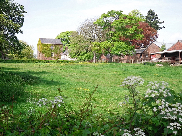
Old Dairy, Brunstock.
- Overview Map Street View The farmhouse and former Dairy to Brunstock House is located on Brunstock Lane in Brunstock. The building dates from the late 1820's with additions dated 1845, …
Co-Curate Page
Church of St John the Baptist, Low Crosby
- Overview Map Street View St John the Baptist's Church in Low Crosby was built in 1854, by R.H. Billings. It was built on the site of a medieval church. It is …
Co-Curate Page
Crosby-on-Eden CE Primary School
- Overview Map Street View Crosby-on-Eden CE Primary School is located in Low Crosby and has about 100 pupils aged 3 to 11. The school became an academy in 2012. The school …
Co-Curate Page
The Stag Inn, Low Crosby
- Overview Map Street View The Stag Inn at Low Crosby dates from the 17th century, and was extended in the 20th century. The building is Grade II listed on the …
Co-Curate Page
Old Carlisle City Boundary Stone, Whiteclosegate
- Overview Map Street View There is an old Carlisle City boundary stone by the B6264, outside No. 2 Whiteclosegate, just north of the B6264 junction with Longlands Road. The boundary …

Co-Curate Page
Wall Mile 64
- <Mile 63 | Mile 64 | Mile 65> Hadrian's Wall - Wall Mile 64 Hadrian's Wall stretches from the east to west coast of England and was an important frontier …

Co-Curate Page
Wall Mile 65
- <Mile 64 | Mile 65 | Mile 66> Hadrian's Wall - Wall Mile 65 Hadrian's Wall stretches from the east to west coast of England and was an important frontier …
Co-Curate Page
Wall Mile 62
- <Mile 61 | Mile 62 | Mile 63> Hadrian's Wall - Wall Mile 62 Hadrian's Wall stretches from the east to west coast of England and was an important frontier …
Co-Curate Page
Wall Mile 63
- <Mile 62 | Mile 63 | Mile 64> Hadrian's Wall - Wall Mile 63 Hadrian's Wall stretches from the east to west coast of England and was an important frontier …

Co-Curate Page
Rickerby House
- Overview Map Rickerby House was built c.1835 for George Head Head (c.1795 - 1876), banker, mine owner and High Sheriff of Cumberland. Landscaped gardens were laid out around the house. In …
Co-Curate Page
Rickerby Park Tower
- A folly, and possibly a dovecote built c.1835, for George Head Head, in the grounds of Rickerby House.[1] The tower is Grade II listed on the National Heritage List for …
Co-Curate Page
Linstock Castle
- Linstock Castle is a farmhouse in Linstock, Cumbria, originally built as a tower house in the 12th or early 13th century. The tower has large blocks of red sandstone, mostly …
Co-Curate Page
Rickerby Park
- Overview About Rickerby Park Map Street View Rickerby Park is a public open space in Carlisle, Cumbria on the banks of the River Eden. The parkland is dotted with …
Co-Curate Page
War Memorial, Houghton
- Overview Map Street View The war memorial in Houghton is located in the churchyard of St John's Church. The memorial was unveiled in April 1922 and is inscribed with the …
Co-Curate Page
Old Dairy, Brunstock.
- Overview Map Street View The farmhouse and former Dairy to Brunstock House is located on Brunstock Lane in Brunstock. The building dates from the late 1820's with additions dated 1845, …
Co-Curate Page
Church of St John the Baptist, Low Crosby
- Overview Map Street View St John the Baptist's Church in Low Crosby was built in 1854, by R.H. Billings. It was built on the site of a medieval church. It is …
Co-Curate Page
Crosby-on-Eden CE Primary School
- Overview Map Street View Crosby-on-Eden CE Primary School is located in Low Crosby and has about 100 pupils aged 3 to 11. The school became an academy in 2012. The school …
Co-Curate Page
The Stag Inn, Low Crosby
- Overview Map Street View The Stag Inn at Low Crosby dates from the 17th century, and was extended in the 20th century. The building is Grade II listed on the …
Co-Curate Page
Old Carlisle City Boundary Stone, Whiteclosegate
- Overview Map Street View There is an old Carlisle City boundary stone by the B6264, outside No. 2 Whiteclosegate, just north of the B6264 junction with Longlands Road. The boundary …
Co-Curate Page
Wall Mile 64
- <Mile 63 | Mile 64 | Mile 65> Hadrian's Wall - Wall Mile 64 Hadrian's Wall stretches from the east to west coast of England and was an important frontier …
Co-Curate Page
Wall Mile 65
- <Mile 64 | Mile 65 | Mile 66> Hadrian's Wall - Wall Mile 65 Hadrian's Wall stretches from the east to west coast of England and was an important frontier …
Co-Curate Page
Wall Mile 62
- <Mile 61 | Mile 62 | Mile 63> Hadrian's Wall - Wall Mile 62 Hadrian's Wall stretches from the east to west coast of England and was an important frontier …


