Topics > Northumberland > Civil Parishes in Northumberland > Edlingham Civil Parish > Historic Buildings and Monuments in Edlingham Civil Parish
Historic Buildings and Monuments in Edlingham Civil Parish
Listed buildings and scheduled monuments in Edlingham Civil Parish, Northumberland, from the National Heritage List for England[1]. Use the Search (below) if looking for a specific building / monument.
| Structure | List No. | Grade | Built~ | Notes |
|---|---|---|---|---|
| 12 Boundary Stones on Boundary with Edlingham Civil Parish | 1371056 | II | ||
| 13 Boundary Stones on Parish Boundary with Callaly Civil Parish | 1052313 | II | ||
| 2 Boundary Stones on Boundary with Longframlington Civil Parish | 1054050 | II | ||
| 2 Boundary Stones on Parish Boundary with Langframlington Civil Parish | 1371078 | II | ||
| 3 Boundary Stones on Boundary with Alnwick Civil Parish | 1371073 | II | ||
| 3 Boundary Stones on Boundary with Denwick (Detached) Civil Parish | 1042030 | II | ||
| 3 Boundary Stones on Boundary with Edlingham Civil Parish | 1371054 | II | ||
| 3 Boundary Stones to North of Black Lough | 1042001 | II | ||
| 4 Boundary Stones on Boundary with Edlingham Civil Parish | 1371055 | II | ||
| 4 Boundary Stones on Boundary with Longframlington Civil Parish | 1054753 | II | ||
| 8 Boundary Stones on Boundary with Alnwick Civil Parish | 1372280 | II | ||
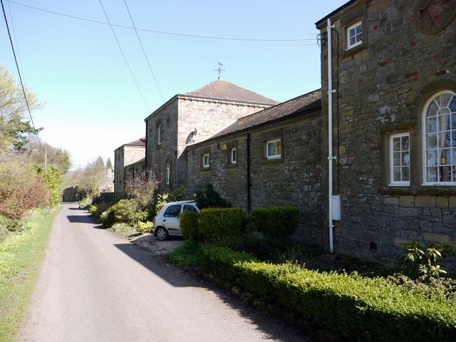
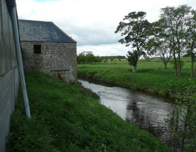
| Abberwick Mill House with Attached Outbuilding to East | 1052348 | II | C19th | Abberwick |
| Bigges Pillar | 1371072 | II | ||
| Bolton Bridge over River Aln | 1371092 | II | ||
| Boundary Stone on Boundary with Edlingham Civil Parish | 1042037 | II | ||
| Broome Hill Farmhouse | 1372614 | II | ||
| Cheviot Chart 40 Metres West of Lemmington Branch | 1371074 | II | ||
| Church of St John the Baptist | 1041990 | I | C11th | Edlingham |
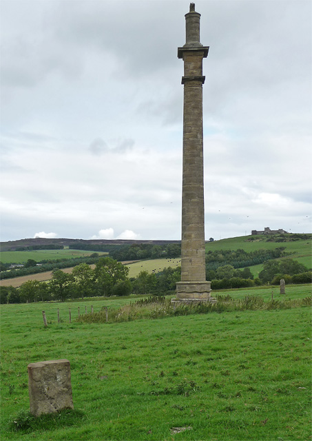
| Column 410 Metres South East of Lemmington Hall | 1371077 | II* | 1786 | Lemmington. Re-sited here 1928. |
| Corn Dying Kiln to South of Mill | 1052321 | II | C19th | Abberwick |
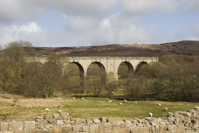
| Disused Railway Viaduct 200 Metres North East of Edlingham Castle | 1372288 | II | 1885 | Edlingham |
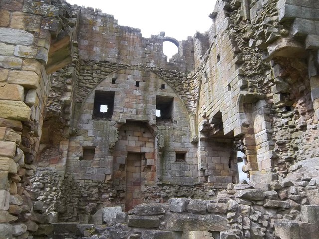
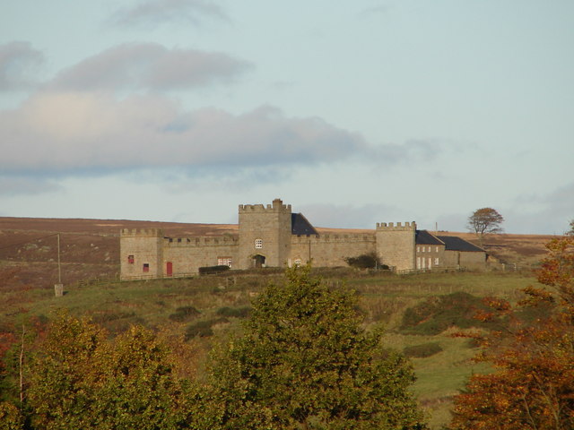
| Edlingham Castle Ruins | 1042032 | I | C13th | Edlingham. An English Heritage site. |
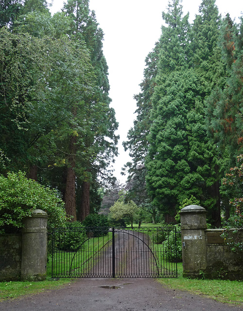
| Entrance Screen and Gates to Lemmington Hall (Sacred Heart Convent) | 1041998 | II | C18th | Lemmington |
| Forge Cottage North East of Lemmington Hall | 1372124 | II | ||
| Garden Cottage with Yard Walls and Outbuildings to Rear | 1367139 | II | ||
| Garden House and Attached Garden Walls to North West of Lemmington Hall | 1372095 | II | ||
| Guide Post on South of Road Junction 300 Metres West of Battle Bridge | 1372611 | II | ||
| Hawe Headstone 5 Metres South of Tower of Church of St John the Baptist | 1041991 | II | ||
| Kennels Cottage 200 Metres North West of Lemmington Branch | 1041995 | II | ||
| Lemmington Branch Farmhouse with Screen Wall and Buildings | 1041994 | II | C18th | Lemmington. 'eye catcher' resembling a hill fort. |
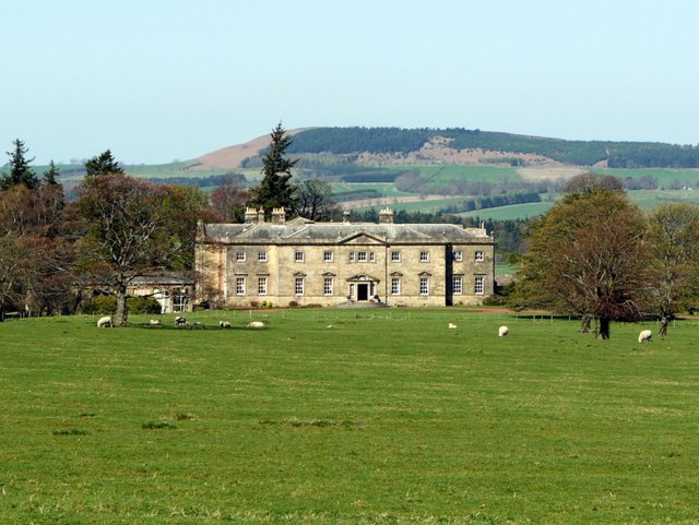
| Lemmington Hall | 1041996 | II* | 1750 | Lemmington |
| Marker Stone 100 Metres North of Corby's Bridge | 1042025 | II | ||
| Marker Stone 100 Metres North of Midrig Bridge | 1051624 | II | ||
| Marker Stone 100 Metres North of Swinhope Bridge | 1042026 | II | ||
| Marker Stone 100 Metres North of Widehope Bridge | 1042027 | II | ||
| Marker Stone 100 Metres South of Corby's Bridge | 1052334 | II | ||
| Marker Stone 100 Metres South of Swinhope Bridge | 1051620 | II | ||
| Milepost 580 Metres East of New Moor Crossroads | 1042023 | II | ||
| Milepost 60 Metres South of Entrance to High Learchild | 1372249 | II | ||
| Milestone 1200 Metres South of New Moor Crossroads | 1042029 | II | ||
| Milestone 700 Metres North of Midrig Bridge | 1042028 | II | ||
| Mill and Adjacent Stable/Granary | 1371051 | II | C19th | Abberwick. Water Mill |
| Mill Cottage with Attached Outbuildings North of Lemmington Hall | 1371075 | II | ||
| Outbuilding on North Side of Road 30 Metres North East of Broome Hill Farmhouse | 1042031 | II | ||
| Pair of Cross Bases 9 Metres South of Church of St John the Baptist | 1371071 | II | ||
| Stable Block Including St Theresa's Cottage to North East of Lemmington Hall | 1041997 | II | c.1915 | Lemmington |
| The Union Stone | 1054060 | II | ||
| Wall North East of Lemmington Hall with Range of Outbuildings Attached to Rear | 1367127 | II | ||
| Walled Garden, Garden Buildings and St Pauls Cottage to North East of Lemmington Hall | 1371076 | II | ||
| Abberwick medieval village, tower house and open field system | 1016350 | n/a | Medieval | Abberwick. Scheduled Monument. |
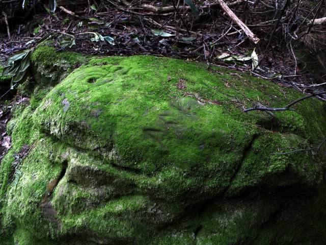
| Prehistoric rock art and Runic inscription in Lemmington Wood | 1418674 | n/a | Bronze Age | Lemmington. Scheduled Monument. |
| Edlingham Castle fortified manor and solar tower | 1011646 | n/a | C13th | Edlingham. Scheduled Monument. |
| Edlingham deserted village | 1003240 | n/a | Medieval | Scheduled Monument. |
| Prehistoric rock art 315m NNW of Wellhope | 1418801 | n/a | Scheduled Monument. | |
| Defended settlement, 700m south east of Glen Aln | 1014063 | n/a | Scheduled Monument. | |
| Defended settlement, 800m NNW of Rough Castles | 1014064 | n/a | Scheduled Monument. | |
| Defended settlement, 400m north west of Rough Castles | 1014065 | n/a | Scheduled Monument. | |
| Alnwick Moor bell pits | 1006419 | n/a | C16th | Multiple C16/17th coal mine shafts |
| Learchild Roman fort | 1006440 | n/a | Roman | High Learchild |
| Alnwick Castle Grounds | 1001041 | I | C18th | Listed Park & Garden. Partly in Edlingham CP |
Primary source: the National Heritage List for England - NHLE is the register of nationally protected historic buildings and sites in England, including listed buildings, scheduled monuments, protected wrecks, registered parks and gardens, and battlefields. The list is maintained by Historic England. Check NHLE for updates and new entries. Secondary sources: British Listed Buildings and Keys to the Past.
Co-Curate Page
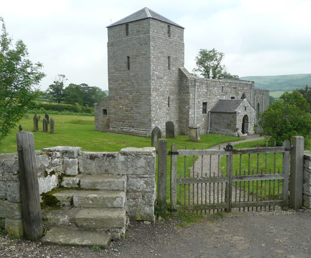
Church of St. John the Baptist, Edlingham
- Overview Map The Parish Church in Edlingham, Northumberland, dates from the 11th century. The tower was added in the c.14th century and used for defence against raiders from Scotland. It …
Co-Curate Page
Edlingham Railway Viaduct
- Overview Map Street View This railway viaduct is located under half a mile north-east of Edlingham in Northumberland, and close to Edlingham Castle. It was built in c.1885 for the …
Co-Curate Page
Edlingham Castle
- Overview About Edlingham Castle Map Street View The ruins of Edlingham Castle are located to the north-east of the village of Edlingham, about 6 miles north-east of Rothbury. The 'castle' was …
Co-Curate Page
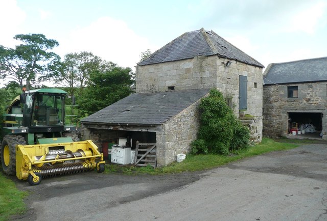
Abberwick Mill
- Overview Aerial View Abberwick Mill is an early 19th century water powered mill by the River Aln. The mill was in working order until about 1925.[1] The mill and associated …
Co-Curate Page
Corn Drying Kiln, Abberwick Mill
- Overview Aerial View There is an early 19th century kiln by the at Abberwick Mill, which was used to dry the corn before milling. It is Grade II listed on …
Co-Curate Page
Abberwick Mill House
- Overview Aerial View The house by Abberwick Mill was built in the early 19th century and is Grade II listed on the National Heritage List for England.
Co-Curate Page
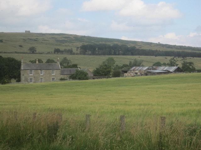
Lemmington Branch
- Overview Map Street View Lemmington Branch built in the late 18th century, is an 'eyecatcher' on Lemmington Bank, about half a mile east of Lemmington Hall. The building incorporates a farmhouse …
Co-Curate Page
Prehistoric Rock Art in Lemmington Wood
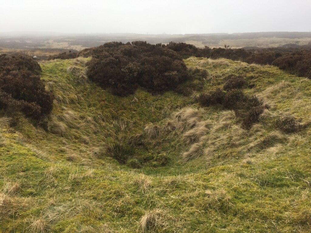
- Deep in Lemmington Woods is a rock with 'cup and rings' carvings, thought to date from the early Bronze Age. The rock is very unusual as it also has later Anglo-Saxon …

Co-Curate Page
Medieval Village (remains), Abberwick
- Scheduled Monument areas - based on Historic England data (Open Government Licence). The remains of the deserted medieval village of Abberwick and located immediately West of Abberwick Farm. They include the …

Co-Curate Page
Learchild Roman fort (Alavna)
- The shallow earthwork remains of a large Roman fort (thought to be 'Alavna') near High Learchild were discovered by arial photography in 1945, and confirmed by subsequent archaeological digs. The fort …
Co-Curate Page
Edlingham Deserted Medieval Village
- Scheduled Monument areas - based on Historic England data (Open Government Licence). To the south of St John's Church in Edlingham is the probable site of the deserted medieval village …
Co-Curate Page
Alnwick Moor bell pits
- Scheduled Monument area - based on Historic England data (Open Government Licence). On Alnwick Moor, north-east of Edlingham in Northumberland, are the remains of over 100 bell pits of 16th-17th …

Co-Curate Page
Church of St. John the Baptist, Edlingham
- Overview Map The Parish Church in Edlingham, Northumberland, dates from the 11th century. The tower was added in the c.14th century and used for defence against raiders from Scotland. It …
Co-Curate Page
Edlingham Railway Viaduct
- Overview Map Street View This railway viaduct is located under half a mile north-east of Edlingham in Northumberland, and close to Edlingham Castle. It was built in c.1885 for the …
Co-Curate Page
Edlingham Castle
- Overview About Edlingham Castle Map Street View The ruins of Edlingham Castle are located to the north-east of the village of Edlingham, about 6 miles north-east of Rothbury. The 'castle' was …
Co-Curate Page
Abberwick Mill
- Overview Aerial View Abberwick Mill is an early 19th century water powered mill by the River Aln. The mill was in working order until about 1925.[1] The mill and associated …
Co-Curate Page
Corn Drying Kiln, Abberwick Mill
- Overview Aerial View There is an early 19th century kiln by the at Abberwick Mill, which was used to dry the corn before milling. It is Grade II listed on …
Co-Curate Page
Abberwick Mill House
- Overview Aerial View The house by Abberwick Mill was built in the early 19th century and is Grade II listed on the National Heritage List for England.
Co-Curate Page
Lemmington Branch
- Overview Map Street View Lemmington Branch built in the late 18th century, is an 'eyecatcher' on Lemmington Bank, about half a mile east of Lemmington Hall. The building incorporates a farmhouse …
Co-Curate Page
Prehistoric Rock Art in Lemmington Wood
- Deep in Lemmington Woods is a rock with 'cup and rings' carvings, thought to date from the early Bronze Age. The rock is very unusual as it also has later Anglo-Saxon …
Co-Curate Page
Medieval Village (remains), Abberwick
- Scheduled Monument areas - based on Historic England data (Open Government Licence). The remains of the deserted medieval village of Abberwick and located immediately West of Abberwick Farm. They include the …
Co-Curate Page
Learchild Roman fort (Alavna)
- The shallow earthwork remains of a large Roman fort (thought to be 'Alavna') near High Learchild were discovered by arial photography in 1945, and confirmed by subsequent archaeological digs. The fort …
Co-Curate Page
Edlingham Deserted Medieval Village
- Scheduled Monument areas - based on Historic England data (Open Government Licence). To the south of St John's Church in Edlingham is the probable site of the deserted medieval village …


