Topics > Organisations > Greenwich Hospital
Greenwich Hospital
The Greenwich Hospital Commissioners were a major landowner in Northumberland, Cumbria and elsewhere in England. Following the Jacobite Rebellion of 1715, the lands of James Radcliffe, 3rd Earl of Derwentwater, were confiscated and after his son died without an heir, the government gifted the estates to the Greenwich Hospital Commissioners in 1735. Greenwich Hospital, in London, had been founded in 1694 as a refuge for disabled seamen, following the naval battle of La Hogue in 1692. Greenwich Hospital continues today as a charity providing support to serving and former serving Royal Navy and Royal Marine personnel and their families.
"Lands owned by Greenwich included much of North and South Tynedale (where the Radcliffes had been barons and lords of the manor), around Amble, Blyth, Hartburn, Rothbury, Tynedale, Scremerston and Wooler areas in Northumberland. In these areas Greenwich Hospital over time erected houses, (often with anchors on - as near Langley), churches, (see Seward, H.H.), as well as carried out agricultural improvements and industrial ventures, (such as Thornborough planned farm, in 1816AD and Langley smelt mill around 1770AD. There are many hospital place-names - e.g. Hospital Plantation, west of Hartburn, Northumberland. Greenwich Hospital Commissioners still own much of Northumberland - particularly around the Scremerston area, though they sold much in throughout the 19th century." (Keys to the Past)
Co-Curate Page
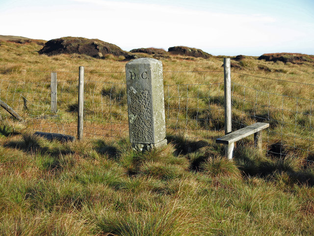
Old Boundary Marker on Scraith Head
- This is one of a series of 5 sandstone boundry markers on the border of County Durham and Cumbria. They date from c.1850 and inscribed "GH" on the west face …
from Geograph (geograph)
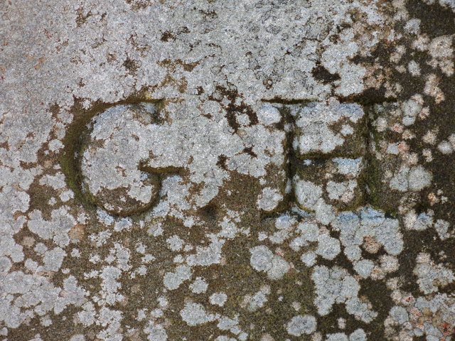
Inscription on the boundary stone at Scraith Head
Pinned by Simon Cotterill
Co-Curate Page
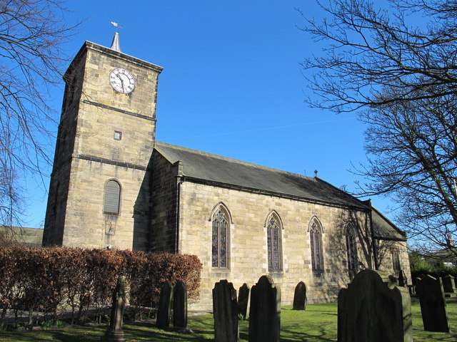
St Cuthbert's Church, Haydon Bridge
- Overview Map Street View St Cuthbert's Church is located on Church Street in Haydon Bridge The parish church was built in 1796 by the Greenwich Hospital Commissioners. It replaced a …
Co-Curate Page
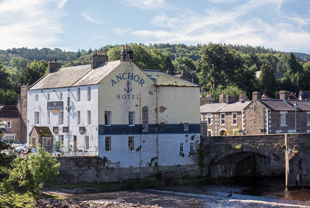
Anchor Hotel, Haydon Bridge
- Overview Map Street View Anchor Hotel is located on John Martin Street, next to the old bridge in Haydon Bridge. The building dates from the 18th century, with later alterations. …
Co-Curate Page
Pumping Engine House, Scremerston Colliery
- ERECTED AD MDCCCXL BY THE COMMISSIONERS OF GREENWICH HOSPITAL JOHN GREY ESQ. RECEIVER MESSRS JOHNSON & CARRS COLLIERY LESSEES THOMAS FORSTER ESQ. VIEWER & ENGINEER MR. W. ELLIOT,TWEEDMOUTH BUILDER

Co-Curate Page
Thornborough Township (Corbridge), 1848
- THORNBOROUGH, a township, in the parish of Corbridge, union of Hexham, E. division of Tindale ward, S. division of Northumberland, 5¾ miles (E.) from Hexham; containing 60 inhabitants. It is …
Co-Curate Page
Whittle Township, Ovingham, 1848
- WHITTLE, a township, in the parish of Ovingham, union of Hexham, E. division of Tindale ward, S. division of Northumberland, 11 miles (W.) from Newcastle; containing 31 inhabitants. It is …
Co-Curate Page
East Thornton Township
- THORNTON, EAST, a township, in the parish of Hartburn, union, and W. division of the ward, of Morpeth, N. division of Northumberland, 6 miles (W.) from Morpeth; containing 51 inhabitants. …
Co-Curate Page
Wark Parish, 1848
- WARK, a parish, in the union of Bellingham, N.W. division of Tindale ward, S. division of Northumberland; containing, with the townships of Warksburn, and Shitlington High and Low Quarter, 940 …
Co-Curate Page
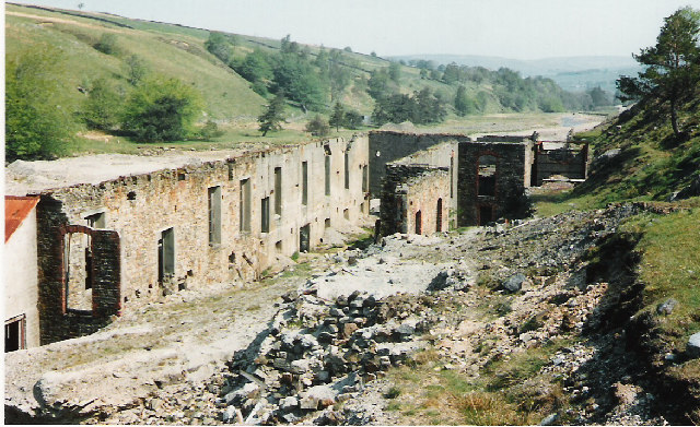
Rotherhope Fell Mine
- Overview Map (area 1) Map (area 2) "...The monument, which is divided into two areas, is situated on the north east side of Rotherhope Fell above Black Burn. It includes …
Co-Curate Page
Graystead Parish, 1848
- GREYSTEAD, or Gaystead, a parish, in the union of Bellingham, N. W. division of Tindale ward, S. division of Northumberland, 20 miles (N.W.) from Hexham; containing, with the townships of …
Co-Curate Page
Humshaugh, 1848
- HUMSHAUGH, a chapelry, in the parish of Simonburn, union of Hexham, N.W. division of Tindale ward, S. division of Northumberland, 5 miles (N. by W.) from Hexham; containing 411 inhabitants. …
Co-Curate Page
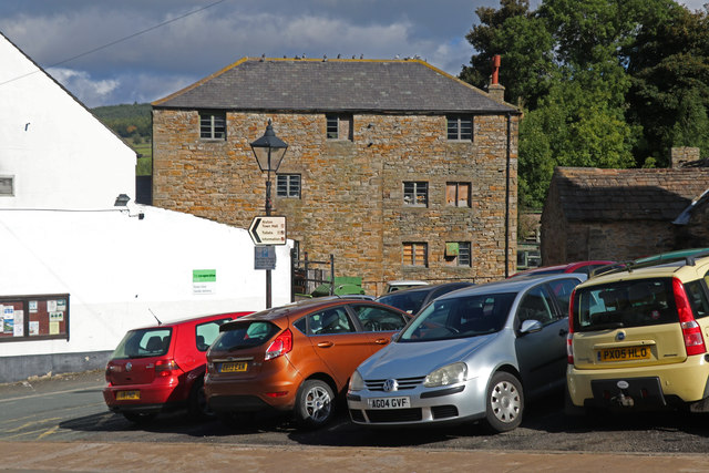
High Mill, Alston
- Overview Map Street View - Front Street View - Rear High Mill, off Front Street in Alston, was originally built as a water-powered corn mill in 1767, by the eminent …

Co-Curate Page
Hartburn Parish, 1855
- Extract from: History, Topography, and Directory of Northumberland...Whellan, William, & Co, 1855. HARTBURN PARISH HARTBURN, a parish partly in the west division of Morpeth Ward, and partly in the …
Co-Curate Page
Dilston Township, 1848
- DILSTON, a township, in the parish of Corbridge, union of Hexham, E. division of Tindale ward, S. division of Northumberland, 3 miles (E. by S.) from Hexham; containing 200 inhabitants. …
Co-Curate Page
Middleton Hall Township, 1848
- MIDDLETON-HALL, a township, in the parish of Ilderton, union of Glendale, N. division of Coquetdale ward and of Northumberland, 1¾ mile (S.) from Wooler; containing 64 inhabitants. Colonel Hughes, the …
Co-Curate Page
Alston Parish, 1848
- ALSTON, or Alston-Moor (St. Augustine), a market-town and parish, forming a union of itself, in Leath ward, E. division of Cumberland, 29 miles (E.S.E.) from Carlisle, and 287 (N.N.W.) from …
Co-Curate Page
Simonburn Parish, 1848
- SIMONBURN (St. Simon), a parish, in the union of Hexham, N.W. division of Tindale ward, S. division of Northumberland; containing, with the township of Haughton and the chapelry of Humshaugh, …
Co-Curate Page
Newbrough Parochial Chapelry, 1855
- Extract from: History, Topography, and Directory of Northumberland...Whellan, William, & Co, 1855. NEWBROUGH is a chapelry, township, and village, the property of the Commissioners of Greenwich Hospital, the Duke of …
Co-Curate Page
Falstone Parish, 1848
- FALSTONE, a parish, in the union of Bellingham, N. W. division of Tindale ward, S. division of Northumberland, 9½ miles (W.N.W.) from Bellingham, and 25½ (N.W. by N.) from Hexham; …
Co-Curate Page
Keswick, 1848
- KESWICK, a market-town, in the parish of Crosthwaite, union of Cockermouth, Allerdale ward below Derwent, W. division of Cumberland, 27 miles (S.S.W.) from Carlisle, and 291 (N.W. by N.) from …
Co-Curate Page
Bellingham (St. Cuthbert) Parish, 1848
- BELLINGHAM (St. Cuthbert), a parish, and the head of a union, in the N. W. division of Tindale ward, S. division of Northumberland; comprising the townships of Charlton East and …
Co-Curate Page
Whittonstall
- Overview Map Street View Whittonstall is a village in Northumberland, located about 4 miles north-west of Consett in County Durham, and 3 miles south of Stocksfield. Within the village is …
Co-Curate Page
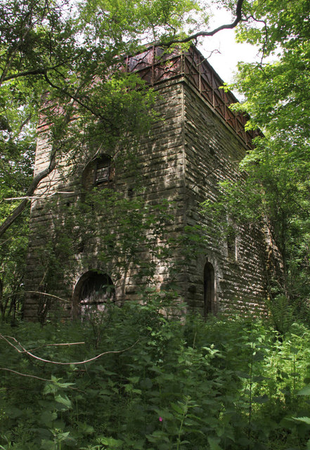
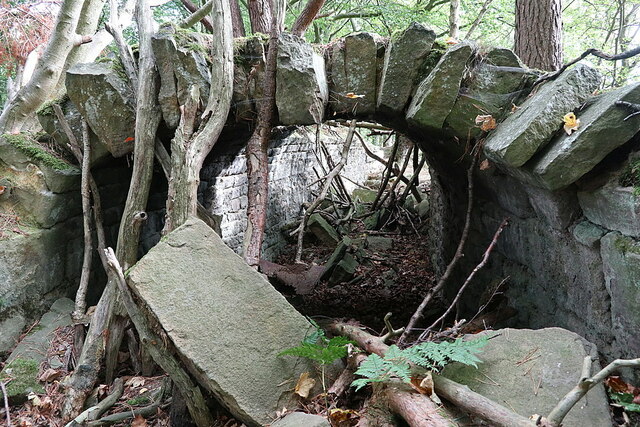
Langley & Blaghill Lead Smelt Mills
- Langley and Blagill were adjacent lead smeltmills, sharing a massive, long horizontal flue system leading to the prominent Stublick Chimney to disperse poisonous fumes. The Langley smelt mill was built …

Co-Curate Page
Old Boundary Marker on Scraith Head
- This is one of a series of 5 sandstone boundry markers on the border of County Durham and Cumbria. They date from c.1850 and inscribed "GH" on the west face …
from Geograph (geograph)
Inscription on the boundary stone at Scraith Head
Pinned by Simon Cotterill
Co-Curate Page
St Cuthbert's Church, Haydon Bridge
- Overview Map Street View St Cuthbert's Church is located on Church Street in Haydon Bridge The parish church was built in 1796 by the Greenwich Hospital Commissioners. It replaced a …
Co-Curate Page
Anchor Hotel, Haydon Bridge
- Overview Map Street View Anchor Hotel is located on John Martin Street, next to the old bridge in Haydon Bridge. The building dates from the 18th century, with later alterations. …
Co-Curate Page
Pumping Engine House, Scremerston Colliery
- ERECTED AD MDCCCXL BY THE COMMISSIONERS OF GREENWICH HOSPITAL JOHN GREY ESQ. RECEIVER MESSRS JOHNSON & CARRS COLLIERY LESSEES THOMAS FORSTER ESQ. VIEWER & ENGINEER MR. W. ELLIOT,TWEEDMOUTH BUILDER
Co-Curate Page
Thornborough Township (Corbridge), 1848
- THORNBOROUGH, a township, in the parish of Corbridge, union of Hexham, E. division of Tindale ward, S. division of Northumberland, 5¾ miles (E.) from Hexham; containing 60 inhabitants. It is …
Co-Curate Page
Whittle Township, Ovingham, 1848
- WHITTLE, a township, in the parish of Ovingham, union of Hexham, E. division of Tindale ward, S. division of Northumberland, 11 miles (W.) from Newcastle; containing 31 inhabitants. It is …
Co-Curate Page
East Thornton Township
- THORNTON, EAST, a township, in the parish of Hartburn, union, and W. division of the ward, of Morpeth, N. division of Northumberland, 6 miles (W.) from Morpeth; containing 51 inhabitants. …
Co-Curate Page
Wark Parish, 1848
- WARK, a parish, in the union of Bellingham, N.W. division of Tindale ward, S. division of Northumberland; containing, with the townships of Warksburn, and Shitlington High and Low Quarter, 940 …
Co-Curate Page
Rotherhope Fell Mine
- Overview Map (area 1) Map (area 2) "...The monument, which is divided into two areas, is situated on the north east side of Rotherhope Fell above Black Burn. It includes …
Co-Curate Page
Graystead Parish, 1848
- GREYSTEAD, or Gaystead, a parish, in the union of Bellingham, N. W. division of Tindale ward, S. division of Northumberland, 20 miles (N.W.) from Hexham; containing, with the townships of …
Co-Curate Page
Humshaugh, 1848
- HUMSHAUGH, a chapelry, in the parish of Simonburn, union of Hexham, N.W. division of Tindale ward, S. division of Northumberland, 5 miles (N. by W.) from Hexham; containing 411 inhabitants. …
Co-Curate Page
High Mill, Alston
- Overview Map Street View - Front Street View - Rear High Mill, off Front Street in Alston, was originally built as a water-powered corn mill in 1767, by the eminent …
Co-Curate Page
Hartburn Parish, 1855
- Extract from: History, Topography, and Directory of Northumberland...Whellan, William, & Co, 1855. HARTBURN PARISH HARTBURN, a parish partly in the west division of Morpeth Ward, and partly in the …
Co-Curate Page
Dilston Township, 1848
- DILSTON, a township, in the parish of Corbridge, union of Hexham, E. division of Tindale ward, S. division of Northumberland, 3 miles (E. by S.) from Hexham; containing 200 inhabitants. …
Co-Curate Page
Middleton Hall Township, 1848
- MIDDLETON-HALL, a township, in the parish of Ilderton, union of Glendale, N. division of Coquetdale ward and of Northumberland, 1¾ mile (S.) from Wooler; containing 64 inhabitants. Colonel Hughes, the …
Co-Curate Page
Alston Parish, 1848
- ALSTON, or Alston-Moor (St. Augustine), a market-town and parish, forming a union of itself, in Leath ward, E. division of Cumberland, 29 miles (E.S.E.) from Carlisle, and 287 (N.N.W.) from …
Co-Curate Page
Simonburn Parish, 1848
- SIMONBURN (St. Simon), a parish, in the union of Hexham, N.W. division of Tindale ward, S. division of Northumberland; containing, with the township of Haughton and the chapelry of Humshaugh, …
Co-Curate Page
Newbrough Parochial Chapelry, 1855
- Extract from: History, Topography, and Directory of Northumberland...Whellan, William, & Co, 1855. NEWBROUGH is a chapelry, township, and village, the property of the Commissioners of Greenwich Hospital, the Duke of …
Co-Curate Page
Falstone Parish, 1848
- FALSTONE, a parish, in the union of Bellingham, N. W. division of Tindale ward, S. division of Northumberland, 9½ miles (W.N.W.) from Bellingham, and 25½ (N.W. by N.) from Hexham; …
Co-Curate Page
Keswick, 1848
- KESWICK, a market-town, in the parish of Crosthwaite, union of Cockermouth, Allerdale ward below Derwent, W. division of Cumberland, 27 miles (S.S.W.) from Carlisle, and 291 (N.W. by N.) from …
Co-Curate Page
Bellingham (St. Cuthbert) Parish, 1848
- BELLINGHAM (St. Cuthbert), a parish, and the head of a union, in the N. W. division of Tindale ward, S. division of Northumberland; comprising the townships of Charlton East and …
Co-Curate Page
Whittonstall
- Overview Map Street View Whittonstall is a village in Northumberland, located about 4 miles north-west of Consett in County Durham, and 3 miles south of Stocksfield. Within the village is …


