Topics > Transport and Travel > Road > Turnpike Roads
Turnpike Roads
From the 1660's turnpike trusts were authorised by Acts of Parliament to build and maintain roads, with the right to collect money (tolls) from travellers on their roads. The trusts were not-for-profit and used their toll income to repair and improve the roads. They could also purchase property to widen or divert existing roads. The roads were called "Turnpikes" as traditionally, a pole or pike, was put across the road and swung round when the toll was paid to allow the traffic through. Over time, gates replaced the use of pikes, often associated with toll houses. Milestones were used to show the distance to major towns along the turnpikes, and coaching inns developed along the turnpike roads.
The number of turnpike roads grew rapidly in the 18th and early 19th centuries. By 1772, trusts covered more than 11,500 miles of road. The last Turnpike Act was passed in 1836. By that time, there had been 942 Acts of Parliament for turnpike trusts in England and Wales, and turnpikes covered around 22,000 miles of road, about a fifth of the entire road network.[1] The introduction of toll gates, particularly on routes which had previously been freely used, were often resented by local communities. However, the growing turnpike road network played an important enabling role in the Industrial Revolution. Later, by the early Victorian era, toll roads were increasingly considered an impediment to trade, and the development of railways led to their decline. However, a lasting legacy of turnpike trusts was the foundation of the modern road network; many of the routes they established remain as major roads today.
Work in progress
| Trust | County(s) | Established | Main Towns | Modern Route(s) |
|---|---|---|---|---|
| Allendale Turnpike Trust | Northumberland | 1826 | ||
| Alnmouth and Hexham Turnpike Trust | Northumberland | 1751 | Hexham, Alnwick, Rothbury, Alnmouth | B1339, A6079 |
| Alnwick and Eglingham Turnpike Trust | Northumberland | 1826 | ||
| Alston Turnpike Trust | Cumberland | 1778 | ||
| Ambleside Turnpike Trust | Westmorland | 1762 | ||
| Appleby and Kendal Turnpike Trust | Westmorland | 1760 | ||
| Brampton and Longtown Turnpike Trust | Cumberland | 1807 | ||
| Breamish Turnpike Trust | Northumberland | 1751 | Longhorsley, Morpeth | |
| Berwick, Norham and Islandshires Turnpike Trust | Northumberland | 1753 | ||
| Brough and Bowes Turnpike Trust | Westmorland | 1742 | ||
| Brough and Eamont Bridge | Westmorland | 1753 | ||
| Brougham Bridge Turnpike Trust | Cumberland | 1812 | ||
| Carlisle and Brampton Turnpike Trust | Cumberland | 1828 | ||
| Carlisle and Eamont Bridge Turnpike Trust | Cumberland | 1753 | Carlisle, Penrith, Eamont Bridge | A6 |
| Carlisle and Temon (Military Road) | Cumberland | 1750 | ||
| Cow-Causey and Buckton-Burn Turnpike Trust | Northumberland | 1747 | Newcastle, Morpeth, Belford | A1 |
| Elsdon and Rudwater Turnpike Trust | Northumberland | 1776 | A68 | |
| Gateshead and Hexham Turnpike Trust | County Durham, Northumberland | 1777 | ||
| Kirkby Stephen and Hawes Turnpike Trust | Westmorland | 1825 | ||
| Ponteland Turnpike Trust | Northumberland | 1748 | ||
| Sedbergh Turnpike Trust | West Riding | 1762 | A683, A684 | |
| Sunderland and Durham Turnpike Trust | County Durham | 1746 |
Co-Curate Page
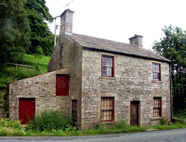
Old Tollhouse, A686
- Overview Map Street View The Gate House is a former tollhouse on the A686 near Coatlith Hill, about ½ mile north of Alston. The building was erected for the Alston …
Co-Curate Page
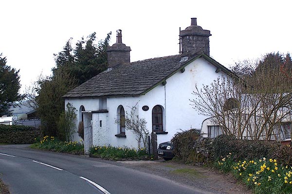
Tollhouse, north-east of Underbarrow
- Overview Map Street View Toll Bar Cottage near Scar Foot, is located on Underbarrow Road, about a mile east of the village of Underbarrow. The former toll house dates from …
Co-Curate Page
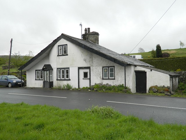
Toll Bar Cottage, Casterton
- Overview Map Street View This former toll house is located on the A683 road, near the entrance to Casterton Golf Course, to the south-west of the village of Casterton. It …
Co-Curate Page
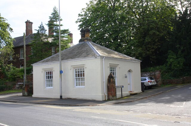
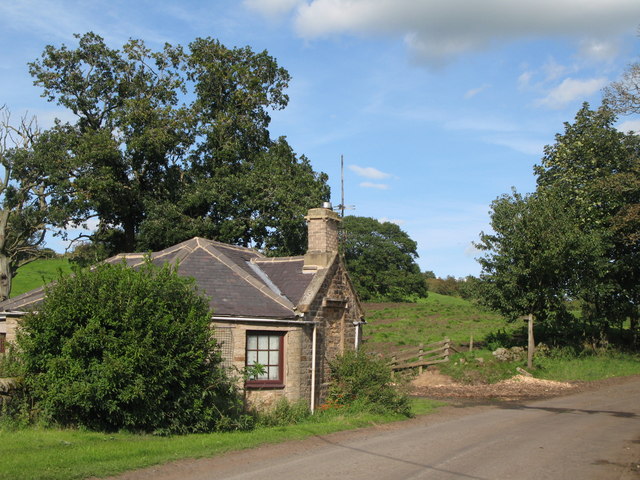
Harraby Toll Cottage
- Overview Map Street View No.258, London Road in Carlisle is the former cottage for the Harraby Toll Gate of the Carlisle to Eamont Bridge Turnpike (established 1752). The cottage was …
Co-Curate Page
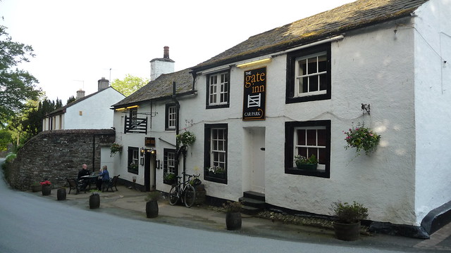
The Gate Inn, Yanwath
- Overview Map Street View The Gate Inn (aka 'The Yanwath Gate') is a public house and resturant in at Yanwath. The pub was originally two seperate houses, which were altered …
Co-Curate Page
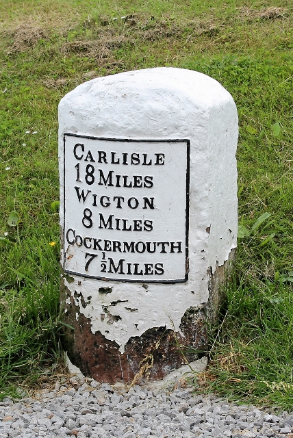
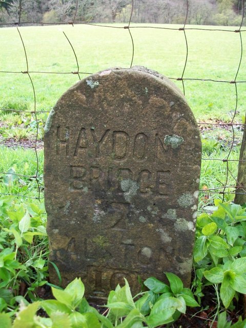
Milestone
- A milestone is a marker placed on a route, such as a road, railway line, or canal - usually indicating the distance to major towns. Milestones were used by the …
Co-Curate Page
Toll Bar Cottage, Whitchester (Melkridge)
- This was a former toll house on the former Turnpike road which passed through Melkridge.
Co-Curate Page
Old Milestone, north of Bearsbridge
- There is an old milestone on the south side of the A686 road, near Tarry Back, about half mile north-east of Bearsbridge. It was erected by the Alston Turnpike Trust …

from https://www.parliament.uk/abo…
Turnpikes and tolls
- Turnpikes have been called "one of the central pillars on which the industrial revolution was based". The quality of roads was vital, because many industries producing light high-value goods, notably …
Added by
Simon Cotterill

Co-Curate Page
Old Tollhouse, A686
- Overview Map Street View The Gate House is a former tollhouse on the A686 near Coatlith Hill, about ½ mile north of Alston. The building was erected for the Alston …
Co-Curate Page
Tollhouse, north-east of Underbarrow
- Overview Map Street View Toll Bar Cottage near Scar Foot, is located on Underbarrow Road, about a mile east of the village of Underbarrow. The former toll house dates from …
Co-Curate Page
Toll Bar Cottage, Casterton
- Overview Map Street View This former toll house is located on the A683 road, near the entrance to Casterton Golf Course, to the south-west of the village of Casterton. It …
Co-Curate Page
Harraby Toll Cottage
- Overview Map Street View No.258, London Road in Carlisle is the former cottage for the Harraby Toll Gate of the Carlisle to Eamont Bridge Turnpike (established 1752). The cottage was …
Co-Curate Page
The Gate Inn, Yanwath
- Overview Map Street View The Gate Inn (aka 'The Yanwath Gate') is a public house and resturant in at Yanwath. The pub was originally two seperate houses, which were altered …
Co-Curate Page
Milestone
- A milestone is a marker placed on a route, such as a road, railway line, or canal - usually indicating the distance to major towns. Milestones were used by the …
Co-Curate Page
Toll Bar Cottage, Whitchester (Melkridge)
- This was a former toll house on the former Turnpike road which passed through Melkridge.
Co-Curate Page
Old Milestone, north of Bearsbridge
- There is an old milestone on the south side of the A686 road, near Tarry Back, about half mile north-east of Bearsbridge. It was erected by the Alston Turnpike Trust …
from https://www.parliament.uk/abo…
Turnpikes and tolls
- Turnpikes have been called "one of the central pillars on which the industrial revolution was based". The quality of roads was vital, because many industries producing light high-value goods, notably …
Added by
Simon Cotterill
Transport and Travel
Road

Alnmouth and Hexham Turnpike Trust

Alston Turnpike Trust
Ambleside Turnpike Trust
Berwick, Norham and Islandshires Turnpike Trust
Brampton and Longtown Turnpike Trust
Carlisle and Brampton Turnpike Trust
Carlisle and Eamont Bridge Turnpike Trust
Cow-Causey and Buckton-Burn Turnpike Trust
Elsdon and Rudwater Turnpike Trust
Gateshead - Hexham Turnpike Road
Middleton-tyas Lane to Greta Bridge and Bowes Turnpike Trust
Newcastle upon Tyne to Carlisle Turnpike Trust
Ponteland Turnpike Trust
Sedbergh Turnpike Trust

")
