Topics > Northumberland > Civil Parishes in Northumberland > Whittingham, Callaly & Alnham Parish Council, area > Historic Buildings and Monuments in Whittingham Vale
Historic Buildings and Monuments in Whittingham Vale
Listed buildings and scheduled monuments in Whittingham Vale, Northumberland, from the National Heritage List for England[1]. Use the Search (below) if looking for a specific building / monument.
| Structure | List No. | Grade | Built~ | Parish | Note |
|---|---|---|---|---|---|
| Church of St Michael | 1303455 | I | C12th | Alnham | |
| Cross Base Circa 20 Yards South of Church of St Michael | 1371408 | II | Alnham | ||
| Farmbuildings Circa 10 Yards East of Pennywells | 1371429 | II | Alnham | ||
| Garden Wall Attached to Front of Pennywells | 1041336 | II | Alnham | ||
| Little Ryle Farmhouse | 1041294 | II | Alnham | ||
| Pennywells (East Cottage and West Cottage) | 1155250 | II | Alnham | ||
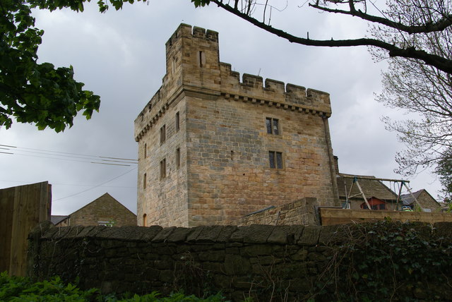
| Tower House | 1232573 | II* | C14th | Alnham | |
| 3 Boundary Stones on Boundary with Callaly Civil Parish | 1042072 | II | Callaly | ||
| 4 Boundary Stones on Parish Boundary with Callaly Civil Parish | 1042075 | II | Callaly | ||
| Boundary Stone on Boundary with Callaly Civil Parish | 1153324 | II | Callaly | ||
| Callaly Castle | 1155463 | I | C14th | Callaly | 1676 additions by Robert Trollope. |
| Callaly Mains | 1371436 | II | Callaly | ||
| Callaly Mill Farmhouse and Attached Stables | 1155545 | II | Callaly | ||
| Farmbuildings Circa 30 Metres West North West of Lorbottle Farmhouse | 1041313 | II | Callaly | ||
| Garden Walls North and North East of Callaly Castle | 1155504 | II | Callaly | ||
| Gatepiers and Gates at North Lodge to Callaly Castle | 1041311 | II | Callaly | ||
| Gatepiers, Screen Walls and Railings at South Lodge to Callaly Castle | 1155524 | II | Callaly | ||
| Gateway Circa 200 Yards North of Lorbottle Hall | 1155593 | II | Callaly | ||
| Gateway, Bridge and Wall Attached to North West of Callaly Castle | 1041309 | II | Callaly | ||
| High Houses, 1 & 2 | 1155557 | II | c.1880 | Callaly | High Houses |
| High Houses, 3 - 6 | 1371437 | II | c.1880 | Callaly | High Houses |
| Lodge Circa 200 Yards North of Lorbottle Hall | 1371438 | II | Callaly | ||
| Lorbottle Farmhouse | 1155583 | II | Callaly | ||
| Lorbottle Hall | 1155587 | II | 1790 | Callaly | |
| Shelter Sheds and Granary Circa 10 Yards West of Callaly Mill Farmhouse | 1041312 | II | Callaly | ||
| South Lodge to Callaly Castle | 1041310 | II | Callaly | ||
| Stable Block Circa 200 Yards North West of Callaly Castle | 1303310 | II | Callaly | ||
| Stable Block Circa 200 Yards South West of Lorbottle Hall | 1303272 | II | Callaly | ||
| Sundial Circa 120 Yards North East of Callaly Castle | 1371435 | II | Callaly | ||
| Tod Le Moor Cottage | 1041315 | II | Callaly | ||
| Walled Garden Circa 20 Yards West of Lorbottle Hall | 1041314 | II | Callaly | ||
| Bird Bath Circa 15 Yards South of Church of St Mary | 1156221 | II | Whittingham | ||
| Bridge of Aln Hotel (closed) | 1041292 | II | c.1840 | Whittingham | Former Coaching Inn |
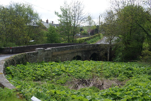
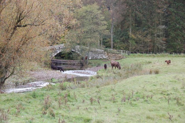
| Bridge over River Aln | 1041268 | II | C19th | Whittingham | |
| Bridge, Terrace Wall and Gateway South and South East of Eslington Park | 1041252 | II | Whittingham | ||
| Carriage House and Stable Circa 50 Yards North West of Eslington Park | 1371447 | II | Whittingham | ||
| Castle Farmhouse | 1371454 | II | Whittingham | ||
| Church of St Bartholomew | 1041257 | I | C12th | Whittingham | Extensively rebuilt 1840 by John Green |
| Churchyard Wall and Gateways South of Church of St Bartholomew | 1303040 | II | Whittingham | ||
| Clavering Memorial 1 Yard South of Church of St Mary | 1041267 | II | Whittingham | ||
| Collingwood Headstone Circa 2 Yards South of Church of St Bartholomew | 1303019 | II | Whittingham | ||
| Cottage and Attached Farmbuildings 5 Yards North of Bridge of Aln Hotel | 1041293 | II | Whittingham | ||
| Eslington Park | 1371446 | II* | 1720 | Whittingham | |
| Forster, Embleton and Hall Headstones Circa 12 Yards South of Church of St Bartholomew | 1156138 | II | Whittingham | ||
| Foggan Headstone Circa 10 Yards South of Church of St Bartholomew | 1041262 | II | Whittingham | ||
| Fountain Circa 30 Yards South of Church of St Bartholomew | 1041265 | II | Whittingham | ||
| Garage and Shed in Garden of Leaside | 1156205 | II | Whittingham | ||
| Gateway to High Green Circa 60 Yards North of Eslington Park | 1041253 | II | Whittingham | ||
| Gibson Headstone Circa 8 Yards North East of Church of St Bartholomew | 1303016 | II | Whittingham | ||
| Headstone Circa 15 Yards East of Church of St. Bartholomew | 1041259 | II | Whittingham | ||
| Headstone Circa 2 Yards South of Church of St Bartholomew | 1041263 | II | Whittingham | ||
| Headstone Circa 5 Yards South of Church of St Bartholomew | 1371451 | II | Whittingham | ||
| Headstone Circa 7 Yards North West of Church of St Bartholomew | 1371452 | II | Whittingham | ||
| Hole in the Wall | 1302935 | II | Whittingham | ||
| Kitchen Garden, Cottage and Cartshed Circa 60 Yards North of Eslington Park | 1041254 | II | Whittingham | ||
| Lanehead and Attached Stables | 1041269 | II | Whittingham | ||
| Moody Headstone Circa 3 Yards South of Church of St Bartholomew | 1041261 | II | Whittingham | ||
| Mountain Farmhouse | 1155962 | II | Whittingham | ||
| Naisbet Headstone Circa 5 Yards South East of Church of St Bartholomew | 1156128 | II | Whittingham | ||
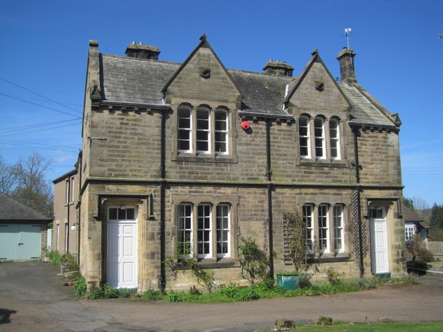
| Northumbria Police Expedition Centre | 1156046 | II | Whittingham | ||
| Office and Stable, with Attached Wall and Gateway Circa 20 Yards West of Eslington Park | 1155938 | II | Whittingham | ||
| Pair of Headstones to Patterson Circa 8 Yards West of Church of St Bartholomew | 1302970 | II | Whittingham | ||
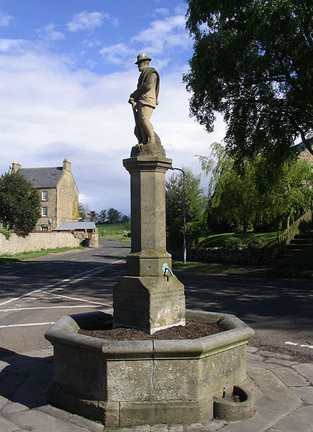
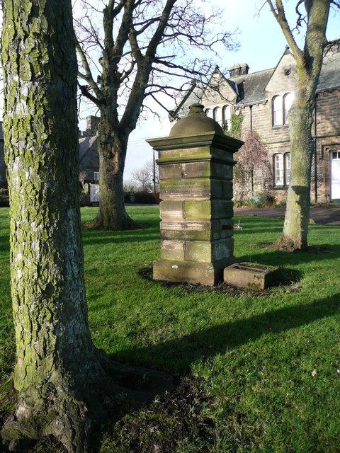
| Ravensworth Statue and Fountain | 1371449 | II | 1905 | Whittingham | |
| Ritchie Headstone Circa 10 Yards South of Church of St Bartholomew | 1156144 | II | Whittingham | ||
| Roman Catholic Church of St Mary and Attached Presbytery | 1371453 | II | 1881 | Whittingham | |
| Stables and Former Billiard Room Attached to West of Eslington Park | 1371448 | II | Whittingham | ||
| Swanson and Archbold Headstone Circa 12 Yards North East of Church of St Bartholomew | 1041258 | II | Whittingham | ||
| The Castle Inn | 1156262 | II | c.1830 | Whittingham | House, former coaching inn. |
| The Lady's Bridge | 1041255 | II | C18th | Whittingham | in Eslington Park |
| The Old Butcher's Shop and Attached Outbuilings | 1303061 | II | Whittingham | ||
| The Old Vicarage | 1302972 | II | Whittingham | ||
| Todd Headstone Circa 3 Yards East of Church of St Bartholomew | 1041260 | II | Whittingham | ||
| Vardy Headstone Circa 15 Yards West of Church of St Bartholomew | 1041264 | II | Whittingham | ||
| Village Farm House | 1302981 | II | Whittingham | ||
| Village Pant or Well | 1041256 | II | 1865 | Whittingham | |
| Wark Cottage | 1303071 | II | Whittingham | ||
| West End Cottage | 1041266 | II | Whittingham | ||
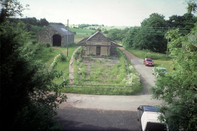
| Whittingham Station | 1155868 | II | 1887 | Whittingham | Former station |
| Whittingham Tower and Attached Cottage | 1371450 | II* | C13th | Whittingham | |
| Whittingham War Memorial Cross | 1442830 | II | Whittingham | ||
| Alnham Castle: a medieval tower house | 1017057 | n/a | Scheduled Monument | ||
| Alnham medieval settlement | 1016713 | n/a | Scheduled Monument | ||
| Alnamsheles medieval settlement, 600m west of Alnhammoor | 1006411 | n/a | Scheduled Monument | ||
| Palisaded settlement, 740m north west of Northfieldhead | 1006412 | n/a | Scheduled Monument | ||
| Leafield Edge medieval settlement and field system | 1006416 | n/a | Scheduled Monument | ||
| Palisaded settlement on Hart Law | 1006417 | n/a | Scheduled Monument | ||
| Univallate hillfort, Romano-British enclosed settlement and medieval farmstead, 224m north west of Chesters | 1006541 | n/a | Scheduled Monument | ||
| Iron age defended settlement, 500m south west of Broomycrook Knowe | 1006545 | n/a | Scheduled Monument | ||
| Enclosures on Meggrim's Knowe | 1006589 | n/a | Scheduled Monument | ||
| Castle Hill camp | 1006609 | n/a | Iron Age | Alnham | Scheduled Monument |
| Round cairn 830m SSE of Ewartly | 1020249 | n/a | Scheduled Monument | ||
| Cairnfield, unenclosed hut circle settlement and area of cord rig 190m north east of Pigdon's Leap | 1020250 | n/a | Scheduled Monument | ||
| Unenclosed hut circle settlement 950m south west of Linhope | 1020251 | n/a | Scheduled Monument | ||
| Enclosed settlement 310m south west of White Gate | 1020252 | n/a | Scheduled Monument | ||
| Unenclosed hut circle settlement 655m south west of White Gate | 1020253 | n/a | Scheduled Monument | ||
| High Knowes palisaded settlements, field system, cord rig, linear boundary and enclosed settlement 600m west of White Gate | 1020254 | n/a | Scheduled Monument | ||
| Palisaded settlement 125m south of North Pike cairn | 1020255 | n/a | Scheduled Monument | ||
| Ingram Farm: prehistoric to post-medieval settlement, agricultural and funerary remains | 1021382 | n/a | Scheduled Monument | ||
| Medieval boundary stone, 220m SSE of Callaly Crag | 1011092 | n/a | Scheduled Monument | ||
| Multivallate hillfort, 550m north of Callaly Castle | 1011094 | n/a | Scheduled Monument | ||
| Medieval boundary stone, 420m SSE of Callaly Crag | 1011091 | n/a | Scheduled Monument | ||
| Medieval boundary stone, 900m south-east of Callaly Crag | 1012120 | n/a | Scheduled Monument | ||
| Medieval boundary stone, 1.1km south-east of Callaly Crag | 1011093 | n/a | Scheduled Monument | ||
| Univallate hillfort and medieval tower, 750m East of Callaly Castle | 1011090 | n/a | Scheduled Monument | ||
| Round cairn, 140m SSW of Macartney's Cave | 1011083 | n/a | Scheduled Monument | ||
| Round cairn, 260m SSW of Macartney's Cave | 1011084 | n/a | Scheduled Monument | ||
| Round cairn, 160m south of Hard Nab | 1011085 | n/a | Scheduled Monument | ||
| Tinkler's Dene univallate hillfort, 400m north-east of Dancing Hall Farm | 1011095 | n/a | Scheduled Monument | ||
| Group of round cairns, 40m east of Hob's Nick | 1011099 | n/a | Scheduled Monument | ||
| Deserted village of Barton | 1006473 | n/a | Scheduled Monument | ||
| Whittingham Conservation Area | - | n/a | Conservation Area |
Primary source: the National Heritage List for England - NHLE is the register of nationally protected historic buildings and sites in England, including listed buildings, scheduled monuments, protected wrecks, registered parks and gardens, and battlefields. The list is maintained by Historic England. Check NHLE for updates and new entries. Secondary sources: British Listed Buildings and Keys to the Past.
Co-Curate Page
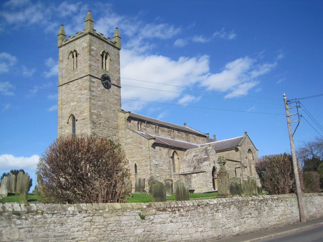
Church of St Bartholomew
- Overview Map Street View St Bartholomew's Church in Whittingham dates from the 12 century. The chancel was rebuilt in c.1725 and the church was extensively rebuilt in 1840 by John …
Co-Curate Page
Callaly Castle
- Overview About Callaly Castle Aerial View Callaly Castle is a Grade I listed building and a substantial country house to the north of the village of Callaly, which is …
Co-Curate Page
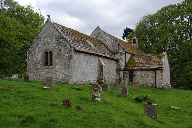
Church of St Michael, Alnham
- Overview About the Church Map Street View The Church of St Michael and All Angels in Alnham was built in the 12th century. It was built on the foundations of …
Co-Curate Page
Ravensworth Statue and Fountain
- Overview Map Street View The fountain with a statue of the 3rd Earl of Ravensworth on Callaly Road in Whittingham was erected in 1905 by his wife, the Countess Caroline. It …
Co-Curate Page
Former Whittingham Station
- < Glanton Station | Alnwick-Cornhill Railway | Edlingham Railway Tunnel >
Co-Curate Page
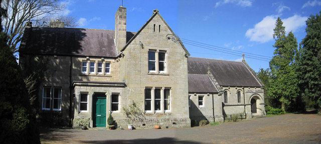
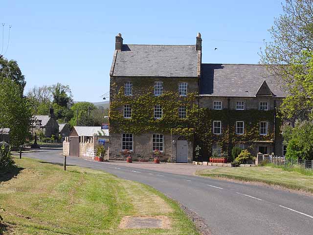
Old Court House and Police Station, Whittingham
- Overview Map Street View Situated on Callaly Road in Whittington, this former police station and police house was built in 1859. For many years this was the Northumbria Police Expedition …
Co-Curate Page
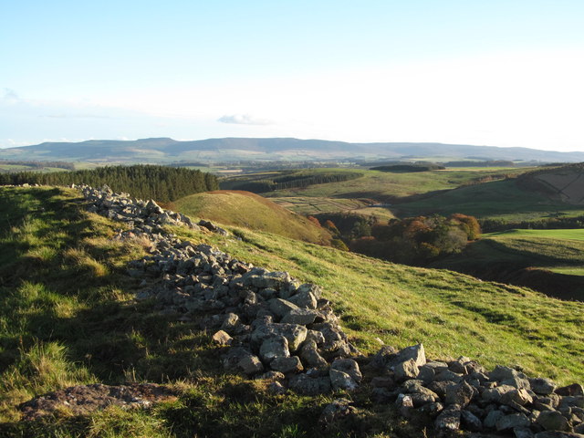
Castle Hill camp, near Alnham
- Overview Map Castle Hill is located about ¼ mile north-east of Old Hazeltonrig and 1½ miles west of the hamlet of Alnham in Northumberland. At the summit of the hill …
Co-Curate Page
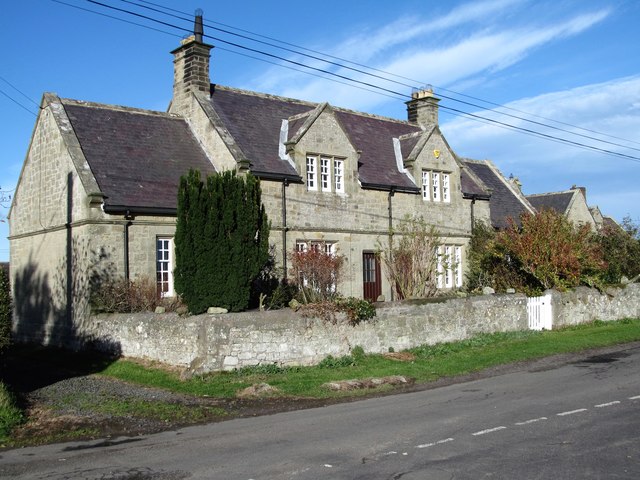
Nos 1 & 2, High Houses, Callaly
- Overview Map Nos 1 & 2, High Houses are a pair of cottages, built in c.1880 as Callaly estate houses. The Tudor-syle cottages are Grade II listed on the National …
Co-Curate Page
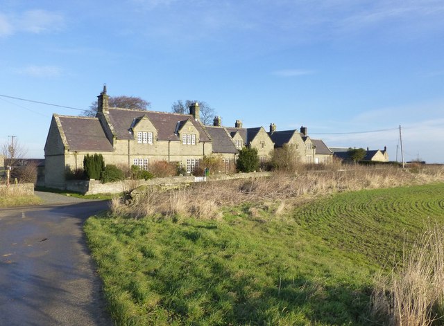
Nos 3 - 6, High Houses, Callaly
- Overview Map Nos 3 - 6, High Houses are two pairs of cottages, built in c.1880 as Callaly estate houses. The Tudor-syle cottages are Grade II listed on the National …
Co-Curate Page
The Castle (former coaching inn)
- Overview Map Street View The Castle is a house in the village of Whittingham (on the market in 2023, described as a "six bedroom period home"). This is the former …

Co-Curate Page
Enclosures on Meggrim's Knowe
- Map showing the Scheduled Monument area of Meggrim's Knowe enclosure, with Linhope and the site of Greaves Ash, to the north. Meggrim's Knowe, located south of Linhope in Northumberland, has …

Co-Curate Page
Church of St Bartholomew
- Overview Map Street View St Bartholomew's Church in Whittingham dates from the 12 century. The chancel was rebuilt in c.1725 and the church was extensively rebuilt in 1840 by John …
Co-Curate Page
Callaly Castle
- Overview About Callaly Castle Aerial View Callaly Castle is a Grade I listed building and a substantial country house to the north of the village of Callaly, which is …
Co-Curate Page
Church of St Michael, Alnham
- Overview About the Church Map Street View The Church of St Michael and All Angels in Alnham was built in the 12th century. It was built on the foundations of …
Co-Curate Page
Ravensworth Statue and Fountain
- Overview Map Street View The fountain with a statue of the 3rd Earl of Ravensworth on Callaly Road in Whittingham was erected in 1905 by his wife, the Countess Caroline. It …
Co-Curate Page
Former Whittingham Station
- < Glanton Station | Alnwick-Cornhill Railway | Edlingham Railway Tunnel >
Co-Curate Page
Old Court House and Police Station, Whittingham
- Overview Map Street View Situated on Callaly Road in Whittington, this former police station and police house was built in 1859. For many years this was the Northumbria Police Expedition …
Co-Curate Page
Castle Hill camp, near Alnham
- Overview Map Castle Hill is located about ¼ mile north-east of Old Hazeltonrig and 1½ miles west of the hamlet of Alnham in Northumberland. At the summit of the hill …
Co-Curate Page
Nos 1 & 2, High Houses, Callaly
- Overview Map Nos 1 & 2, High Houses are a pair of cottages, built in c.1880 as Callaly estate houses. The Tudor-syle cottages are Grade II listed on the National …
Co-Curate Page
Nos 3 - 6, High Houses, Callaly
- Overview Map Nos 3 - 6, High Houses are two pairs of cottages, built in c.1880 as Callaly estate houses. The Tudor-syle cottages are Grade II listed on the National …
Co-Curate Page
The Castle (former coaching inn)
- Overview Map Street View The Castle is a house in the village of Whittingham (on the market in 2023, described as a "six bedroom period home"). This is the former …


