Topics > Heritage Sites > Newcastle Town Walls > Riverside Tower
Riverside Tower
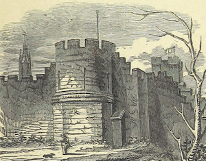
![]() The Riverside Tower (aka Water Tower) was an early 15th century addition to the Newcastle Town Walls. It stood where the Copthorne Hotel is now located, near the River Tyne. From the late 17th century, it became the meeting place of the Housecarpenters Company (to 1713), and then of the Company of Sailmakers. Along with other sections of the walls, the tower was removed in c.1763, to improve access to the Quayside. The foundations and buried remains of the tower, beneath the hotel, are part of a Scheduled Monument, which also includes an upstanding section of the Town Wall, near Hanover Street, and the site of Close Gate.
The Riverside Tower (aka Water Tower) was an early 15th century addition to the Newcastle Town Walls. It stood where the Copthorne Hotel is now located, near the River Tyne. From the late 17th century, it became the meeting place of the Housecarpenters Company (to 1713), and then of the Company of Sailmakers. Along with other sections of the walls, the tower was removed in c.1763, to improve access to the Quayside. The foundations and buried remains of the tower, beneath the hotel, are part of a Scheduled Monument, which also includes an upstanding section of the Town Wall, near Hanover Street, and the site of Close Gate.
From Sand Gate the town wall extended along the Quayside to the Tyne bridge. The foundation of this part of the wall was discovered in 1823, twelve feet below the surface, and under the scite of the Maison de Dieu. "On the top of this wall," says Bourne, "was a walk, and at the bottom of it a great many gates, called Water Gates. These, in the reign of king James I. Anno 1616, were ordered to be locked up every night, except one or two to stand open for the masters and seamen to go to and fro to their ships. This was done to prevent servants casting ashes and other rubbish into the river; and those two gates were watched all night long." A passage leading from the Sandhill to the High Crane still retains the name of the Water Gate; but in the common council books, 1649, it is, says Brand, called "the Windowes Gate." Leland, who visited Newcastle in the time of Henry VIII. tells us there were "a strong wardyd gate at Gateshed, a strong ward and towre on Tynebridge, and a gate at the Bridge-end." The wall extending from the Sandhill to Sand Gate being found "no longer of any use for defence, but a great obstruction to carriages, and hinderance to the dispatch of business," the corporation petitioned for leave to remove it at their own expenses, and to make use of the stones for building a church. On November 17, 1762, an order of the privy council was signed, in compliance with this request; and on January 10, 1763, the workmen began to pull down the wall and gates upon the Quay. The fortified line from the Bridge-end to Close Gate is described in Speed's map of Northumberland, which contains a plan of Newcastle of the date of 1610.
Extract from Eneas Mackenzie, Historical Account of Newcastle-Upon-Tyne Including the Borough of Gateshead. Mackenzie and Dent, Newcastle-upon-Tyne, 1827.
Scheduled Monument (#1019814): Newcastle upon Tyne town defences: section of curtain wall including Closegate and Water Tower
Click the headings below to expand (selected extracts from the Historic England scheduling)
The southern end of the curtain wall was subsequently remodelled in order to incorporate a staircase which gave access to a tower, known as Water Tower, which was added to the town defences in the early 15th century. It is situated in the angle formed by the junction of the western side of the defences and the later riverside section of curtain wall forming the south side of the circuit. An engraving of the tower made in 1745 shows it as a square, crenellated structure, and it is recorded as still partially standing in 1789. An engraving of the tower in 1846 depicts it as having three storeys with its upper parts rebuilt in brick. From the late 17th century and through the 18th century the tower was the meeting house for the Company of Housecarpenters and subsequently the Company of Sailmakers.
The plan of Water Tower was uncovered by excavation in 1988. The tower, square in shape, measures 6.5m north to south by 6m east to west and has walls ranging from 1.02m to 1.10m wide. The foundations of the south and west walls are between 2.1m to 2.3m wide while those of the north and east are 1.20m wide. There is an entrance way into the tower through the east end of the north wall which retains both the sill and one of the door jambs. In the north west angle of the tower's ground floor there was a fireplace indicated by areas of reddening on the adjacent stonework. The excavation also revealed that the ground floor of the tower was occupied in the years following the English Civil War until the mid-18th century as occupation deposits and the remains of light timber screens or room partitions were discovered.
Attached to the eastern side of Water Tower there is a short length of riverside curtain wall, which was uncovered by excavation and survives below ground level as a buried feature. This wall runs parallel to the River Tyne and was constructed in the early 15th century. The curtain wall is on average 1.74m wide, 6.25m long and stands to a maximum height of 4.4m; its south, external face contains two chamfers at its base.
Scheduled Monument area - based on Historic England data (Open Government Licence).

from http://twsitelines.info/SMR/1…
Tyne and Wear HER(1509): Newcastle town wall, Riverside Tower
- "An early 15th century addition at the point where the town wall reached the Tyne, and of one build with the short stretch of wall along the river's edge (HER …
Added by
Simon Cotterill

from http://www.british-history.ac…
Descriptive and Historical Account of the Town and County of Newcastle-upon-Tyne, Eneas Mackenzie, 1827
- Historical Account of Newcastle-Upon-Tyne Including the Borough of Gateshead. Free content digitised by double rekeying.
Added by
Simon Cotterill

from https://historicengland.org.u…
Newcastle upon Tyne town defences: section of curtain wall including Closegate and Water Tower - Scheduling
- ....Despite some parts of this section surviving below the level of the ground as buried features, the remains of the medieval curtain wall between Hanover Street and the River Tyne …
Added by
Simon Cotterill

from http://twsitelines.info/SMR/1…
Tyne and Wear HER(1509): Newcastle town wall, Riverside Tower
- "An early 15th century addition at the point where the town wall reached the Tyne, and of one build with the short stretch of wall along the river's edge (HER …
Added by
Simon Cotterill
from http://www.british-history.ac…
Descriptive and Historical Account of the Town and County of Newcastle-upon-Tyne, Eneas Mackenzie, 1827
- Historical Account of Newcastle-Upon-Tyne Including the Borough of Gateshead. Free content digitised by double rekeying.
Added by
Simon Cotterill
from https://historicengland.org.u…
Newcastle upon Tyne town defences: section of curtain wall including Closegate and Water Tower - Scheduling
- ....Despite some parts of this section surviving below the level of the ground as buried features, the remains of the medieval curtain wall between Hanover Street and the River Tyne …
Added by
Simon Cotterill