Topics > Northumberland > Civil Parishes in Northumberland > Rothbury Civil Parish > Rothbury Parish, 1855
Rothbury Parish, 1855
Extract from: History, Topography, and Directory of Northumberland...Whellan, William, & Co, 1855.
ROTHBURY PARISH
ROTHBURY parish is bounded on the north by Whittingham, on the west by Elsdon, on the south by Hartburn, Nether-Witton, and Long Horsley, and on the east by Edlingham. It is about nine miles in length by the same in breadth, and comprises twenty-eight townships, whose united area is 34,798 acres. The population in 1801, was 2,236; in 1811, 2,428; in 1821, 2,609; in 1831, 2,869; in 1841, 2,555; and in 1851, 2,545 souls. The soil of this parish exhibits great variety. In some parts we find rich pastures and fine corn-fields, in others, sterile hills, naked rocks, and black heaths. The famous forest of Rothbury has long since disappeared, and widely scattered farm-houses and cottages occupy its site. The whole of the parish is well watered by the river Coquet, and several smaller streams. Whinstone, limestone, ironstone, and coal are found here.
BICKERTON is a township, situated four miles west by south of Rothbury, the property of Henry Smails, Esq. It contains 505 acres, and its rateable value is £382. The number of inhabitants in 1801, was 31; in 1811, 15; in 1821, 18; in 1831, 26; in 1841, 18; and in 1851, 26 souls. This township occupies a pleasant plain, having a semicircular ridge of moorland on the south-east, and Coquet-haughs, with other pastures, on the north and west.
DIRECTORY. Messrs. George Bolam and Sons, farmers.
CAISTRON is a township and hamlet, the property of Henry Smails, Esq., and the heirs of the late Lieutenant-General Ord. The township comprises an area of 400 acres, and its rateable value is £504. The number of inhabitants in 1801, was 53; in 1811, 50; in 1821, 43; in 1831, 43; in 1841, 54; and in 1851, 51 souls. THE HAMLET of Caistron is situated four miles west of Rothbury. Here is a school which possesses an endowment of £6 per annum, left, in 1779, by William Hall, for the encouragement of the teacher.
DIRECTORY. Robert Milburne, schoolmaster; George Storey, farmer; and Joseph Witherson, farm-steward
CARTINGTON is a township and hamlet. containing 1,912 acres, the property of Mr Tower, and Fenwick, Esq. The rateable value of the township is £1,014 13s. 4d., and its population in 1801, was 96; in 1811, 83; in 1821, 79; in 1831, 93; in 1841, 66; and in 1851, 102 souls. Limestone of excellent quality is found here. This manor was formerly the property of a family that bore the local name, and from whom it passed to the Radcliffes. It was subsequently held by the Widdringtons, and the Talbots, coming ultimately into the possession of the present proprietors. THE HAMLET of Cartington is about two and a half miles north-west by north bf Rothbury. Here are the ruins of an ancient castle, but when, or by whom it was erected, is alike unknown.
DIRECTORY. George Crawford, farmer, Cartington; George Crawford, farmer, Whittle; John Robson, stonemason and freeholder; George Stephenson, farmer and overseer, Bank Head; and James Wilson, farmer, Sandylands.
DEBDON is a township one mile and three quarters north of Rothbury. It contained in 1801, 16 ; in 1811, 16; in 1821, 18; in 1831, 14; in 1841, 13; and in 1851, 16 inhabitants. The rateable value is £75, and the Duke of Northumberland is proprietor. This township includes the northern portion of Rothbury Forest, and contains an excellent chalybeate spring, the waters of which are considered to be very efficacious in scorbutic diseases.
DIRECTORY. Matthew Scott, farmer.
FALLOWLEES, a township, the property of Sir Walter Trevelyan, Bart., is situated on the north side of the Roughless-burn, five and a half miles S.S.W. of Rothbury. Its area is 1,547 acres, and its rateable value £260. The population in 1801, was 13; in 1811, 9; in 1821, 3; in 1831, 8; in 1841, 7; and in 1851, 4 souls.
FLOTTERTON, a township situated five and a half miles west by north of Rothbury, is the property of Mrs. Weallens and Lord Ravensworth. Its population in 1801, was 75; in 1811, 115; in 1821, 92; in 1831, 95; in 1841, 64; and in 1851, 77 souls. It contains 768 acres, and its rateable value is £753. This township was formerly the property of the celebrated family of Umfraville, and the soil is a good strong loam. FLOTTERTON HOUSE, the seat and property of Mrs. Weallens, is situated on the northern bank of the Coquet.
DIRECTORY. William Armston, gardener; Thomas Pallister, farmer, Plainfield ; John Scott, steward ; and Mrs. Wealleans, land proprietor, Flotterton House.
HEPPLE is a township and hamlet in Rothbury parish, the property of Sir Waiter B. Riddell, Esq. The township contains 3,874 acres, and its rateable value is £718. The number of its inhabitants in 1801, was 58; in 1811, 102; in 1821, 111; in 1831, 101; in 1841, 61; and in 1851, 28 souls. The West Farm House is delightfully situated on an eminence north of the river Coquet, overlooking a handsome valley. THR HAMLET of Hepple is four and a half miles west of Rothbury.
DIRECTORY. John Gray, farmer, Middle Hepple; James Harvey, farmer and overseer, West Hepple ; John Spour, woodman ; and John Wilson, lime merchant.
HEPPLE DEMESNE, a township in this parish, is situated five miles west of Rothbury. Its area is 1,531 acres, and its rateable value £410. Population in 1801, 22; in 1811, 52; in 1821, 45 ; in 1831, 59; in 1841, 23; and in 1851, 26 souls. From many concurring circumstances in history, there is reason to infer that the village of Hepple was part of the demesnes of Ceolwo1f, the last Earl of Northumberland, under William the Norman. William, on his return from Scotland, deprived Cospatric of the earldom, and bestowed it on Waltheof, who was now become a great favourite, and to whom he gave his niece Judith in marriage, anno 1073. In the following year a conspiracy was formed by many of the principal Normans, who prevailed on Waltheof to take part in it at a feast, when they all became intoxicated. When rest had dispelled the fumes of liquor, it was seen in a very different light by the unhappy Waltheof, who became restless and pensive. At length, to relieve his loaded heart, he communicated the affair to his wife, of whose fidelity he had no doubt; but the faithless Judith, whose affections were fixed on Ivo Tailbois, Baron of Kendal, glad of an opportunity of ruining her husband, sent a trusty messenger into Normandy to reveal the plot to her uncle, and aggravated the guilt of her husband, who was afterwards condemned and executed. She then became the wife of Ivo Tailbois.
In the reign of Henry I, the Tailbois family were seized of the barony of Hepple, cum membris suis, but subsequently, it would appear, the name of Tailbois was dropped, and that of De Heppale assumed - a custom then common on the acquisition by a cadet of territorial property, sufficient to become the foundation of an independent family. Connected with the Tailbois family by matrimonial ties, were the Kurtenays and the De Battermunds, or De Bandements (in modern orthography, Courtenay and Bateman), who for some time held lands here. The barony was of great extent, comprising at the same time Great Tosson, Little Tosson, Bickerton, Warton, Flotterton, Newton, Fallowlees, Nether Trewitt, and Over Trewitt.
The Hepples were seised of the barony till, by the marriage, in 1331, of Sir Robert Ogle with Annabella, daughter and heiress of Sir Robert de Heppale, knight, it came into the possession of the Ogles, in whose family it continued till the reign of Charles I, when it passed with Catherine, Baroness Ogle, to Sir Charles Cavendish, of Welbeck, father of the first Duke of Newcastle, celebrated in the civil wars as "the soul of the royal cause in the north." He contributed 10,000 men and a troop of horse to the king's expedition against the Scots, and according to a calculation of the Duchess, was plundered and injured to the extent of £733,579. The grand-daughter of the Duke, the Lady Margaret Cavendish, marrying John Holles, Earl of Clare, carried the barony of Hepple into that family. The Earl leaving only an heiress, the Lady Henrietta, it passed with her to Edward Harley, Earl of Oxford and Mortimer, and founder of the Harleian Librttry. It then came into the hands of the Bentinck family, by the marriage, in 1734, of the second Duke of Portland with the Lady Margaret Cavendish Harley, only daughter and heiress of the Earl of Oxford. It is now the property of Sir Walter Buchanan Riddell, Bart., into whose family it came in 1803, by purchase from the late Duke of Portland.
HEPPLE CASTLE is built on the north side of the river Coquet, about four miles west from Rothbury, and near the boundary of the parish. It stands in a secluded but picturesque situation, overlooked by a broken ascent of bold, romantic, heather-clad hills, rising one above another. At present it is in the last stage of dilapidation. About half a century ago, the exterior walls of a strong and stately tower were still standing, tolerably entire, and which had probably been the manor-house of the proprietors of Hepple, as it is said the court-leet of Hepple lordship was held here in former times, until the castle, being ruined by the Scots, was totally abandoned by the lord, who removed his court to Great Tosson, where the tenants of Hepple and the demesne annually convene to this day. In erecting a few farmsteads, an effort was made to demolish the retaining fragments of this strong tower ; but the attempt, after repeated trials, was relinquished by the workmen, who found it easier to cut stones from the hardest quarry than to separate these from the cement. This castle was probably the first of the chain of forts which exteuded from thence to Warkworth, and which was intended to form a barrier against the incessant and destructive incursions of the warlike borderers. Upon a fine summit called the Kirk Hill, about half a mile west of Hepple, stood a chapel, the remains of which were removed about the year 1760. In the chancel the fragment of a tomb-stone, with its supporters, was discovered, and what is curious, was standing in a north and south direction. This monument was much defaced, and it was with extreme difficulty that the following parts of the inscription were deciphered :-
Here lies......Countess of ........
.....who died ...... her age ....
...............................
...............................
I lov'd my lord, obey\I my king,
And kept my conscience clear,
Which Death disarmeth of his sting,
And Christians all endear.
My puissant posterity
Still the forlorn'd befriend;
Peace, pleasure, and prosperity
My tenantry attend.
Farewell survivors in the gross !
When you behold my bust;
Lament your late liege lady's loss,
Then blending with the dust.
An old dirge states her to have been the very mirror of meekness, affable to every one, and consequently idolised by all. She is also represented as having been a heroine on horseback, unrivalled in the chase, and warmly devoted to athletic exercises; but above all, she is praised for relieving the oppressed. Previous to her death she composed her own epitaph, but the words of this doleful ditty, which consisted of seven stanzas, are, it is to be feared, for ever lost.
About a hundred paces west of the site of this chapel, are the traces of several buildings, where Old Hepple formerly stood. It is said to have been destroyed by the border wars. At a short distance to the north-west of Hepple is a British entrenched stronghold called Hetchester. The interior length of the entrenchment is 140 yards, and the breadth 90 yards; the breadth of the inner ditch is 18 feet, and of the exterior ditch 15 feet; each of the rampiers is 15 feet in height and 6 feet in breadth. The hill being very steep and difficult of access on the north-west side, the fort has had but two ditches in that part. Most of the intrenchments have been levelled, and it is only on the north-west side that they remain in any degree of good preservation. The foundations of the ancient buildings are very perceptiule within the entrenchment; but all traces of this remarkable castramentation will soon be obliterated, as excavations for lime are proceeding in the heart of the works. On the opposite side of the Coquet is the military station called Harehaugh. West of Hepple, and near the site of the old chapel, a number of urns have been found. Hetchester, as its name imports, was, in subsequent times, occupied by the Romans.
The barony of Hepple forms part of a grazing district, abounding with beautiful sheepwalks, which were formerly the scene of constant theft and spuilzie, and were occupied with little profit. This state of "rief and felonie'' is well described in a border ballad:-
Rookhope stands in a pleasant place,
If the false thieves wad let it be ;
But away they steal our goods apace,
And ever an ill death may they dee.
Ah me ! is not this a pitiful case,
That men dare not drive their goods to the fell,
But limmer thieves drive them away,
That fear neither heaven nor hell?
Then in at Rookhope Head they come,
They run the forest but a mile;
They gather'd together in four hours,
Six hundred sheep within a while.
But such is the altered state of things in consequence of the security now afforded by law and order, that a tract of land in the same district (Kidland Lordship, the property of Sir Thomas Legard, Bart., which, in 1631, was let for only £5 a year, was, in 1731, let for £400, and since the commencement of the present century, for £3,000 per annum. In this locality the Cheviot breed of sheep are found in their full perfection ; the sweet green herbage on which they pasture seems to be peculiarly favourable for breeding this useful and beautiful race of animals.
Hepple was the native place of the renowned Robert Snowdon, who, in the sixteenth year of his age, fought and slew John Grieves, a celebrated Scotch champion, in a pitched battle with small swords, at Gamblepath, on the borders. This occurred some time before the Union. Snowdon had a black horse which he valued greatly. It was stolen one night, when he, accompanied by two friends, pursued the thief to the Scottish border, where, from a wretched hovel, his voice was answered by the neighing of his favourite, on which the unsuspecting Snowdon dismounted and rushed into the house; but while in the act of unloosing his horse, he was run through the body by a concealed assassin.
Hepple was also the birth-place of Mable Snowdon, who belonged to the same family as the above renowned swordsman. She was the wife of John Coughron (Scotice Oochran), and mother of the admirable George Coughron, who was born at the adjoining village of Wreighill, on the 24th August, 1752. This prodigy of genius, had he lived, would have been a star of the first magnitude. He excelled all his competitors in the mathematical sciences, and soared above the reach of the hoary headed philosopher. As a poet also he bid fair to have attained pre-eminence. The attachment of this wonderful youth to books appeared at a very early age. At night his tamp frequently burned out when conversing with the immortal Euclid, Newton, Simpson, Emerson, Maclaurin, and others, with whose grand principles he became intimately acquainted. His perseverance was perhaps unequalled, but his progress supported his spirits, and he always returned to the spade or the plough with the greatest cheerfulness. During his brief career he had obtained no fewer than ten prizes for answering questions in fluxions alone. He challenged all the mathematicians of his time to answer the prize question in the Gentleman's Diary for 1772, which was not accepted, and the solution was given by himself. This fact alone established his superiority in the mathematical sciences. Previous to his death, occasioned by the small pox, which happened at Newcastle-upon-Tyne, the 10th Jan., 1774, he was engaged on very liberal terms, by Dr. Maskelyne, astronomer royal, to be his calculator. A bright path to the temple of fame was opened to him, and the muses had women for him a wreath of immortality; but his mighty soul, too great for this world, burst its clay prison, and soared aloft to brighter scenes and nobler pursuits.
DIRECTORY. Peter Carr & Sons, blacksmiths and agricultural implement makers; John Clark, joiner and cartwright; Mary Elliott, farmer, Old Tower; and George Grey, farmer, White Field.
HESLEY HURST township is situated three and a half miles S.S.E. of Rothbury. It contains 659 acres, the property of the Duke of Northumberland, and its rateable value is £309. Population in 1801, 57; in 1811, 41; in 1821, 46; in 1831, 40; in 1841, 36; and in 1851, 47 souls. This township abounds in coal and limestone, and is grazed by Mr. Liddell of the Lee.
HOLLINGHILL township is the property of the Duke of Northumberland, and is situated four miles south by west of Rothbury. It contains 5,264 acres, and the number of its inhabitants in 1801, was 127; in 1811, 124; in 1821, 130; in 1831, 109 ; in 1841, 114; and in 1851, 111 souls.
|
Hudson Thomas, schoolmaster and overseer Pyle Grace, vict. Crown and Thistle Pyle Thomas, blacksmith
Farmers Carr Robert, Moral Hurst |
Craigald Thomas, The Hut Nichol George, Blagdon Burn Shillinglow Edward, Cold Side Spearman Gideon and Robert (and yeomen), Newbiggin Young John and Robert, Hollinghill |
LEE WARD, a township containing 1,793 acres, is situated three miles S.S.E. of Rothbury, and its rateable value is £575. The population in 1801, was 92; in 1811, 111; in 1821, 93; in 1831, 103; in 1841, 91 ; and in 1851, 92 souls. Principal proprietor the Duke of Northumberland. The soil is principally light, and there is a large quantity of moorland on the north side. Here is a school in connection with the Rothbury Grammar School, and receives £5 per annum from the same endowment. The school and a cottage for the master, together with about fourteen acres of land, are given by the Duke of Northumberland, for which some of the poor children are taught free.
DIRECTORY. Anthony Hutchinson, schoolmaster; Joseph Nicholson, joiner; and the farmers are John Liddell, (and overseer), The Lee; Edward Potts, Crook ; and John Redhead, Brockley Hall.
MOUNT HEALY is a township two and a half miles S.S.E. of Rothbury. It comprises an area of 442 acres, the property of the Duke of Northumberland, and its rateable value is £270 1 9s. 0d. It contained in 1801, 24; in 1811, 50; in 1821, 38; in 1831, 47; in 1841, 36; and in 1851, 50 inhabitants. There are two corn mills in this township.
DIRECTORY. James Richardson, miller and farmer, Little Mill; Joshua Tenant, miller, Thrum Mill.
NEWTON township, the property of the Duke of Northumberland, is situated one mile W.S.W. of Rothbury. Its area comprises 951 acres, and its rateable value is £595. Population in 1801, 28; in 1811,42; in 1821, 66; in, 1831, 55; in 1841, 57; and in 1851, 51 souls. This township occupies the northern declivity of a ridge of rocks, where the streams of Cowett Wells unite, and after dashing down the rocky steep, and passing Tosson Mill, are lost in the Coquet. The Carterside estate is situated on the east side of this township.
DIRECTORY. The farmers are James Howey, Cartetside; Robert Nevins; and William Thompson, West Newton.
PAPERHAUCH is a township and hamlet, the property of the Duke of Northumberland. The township contains 986 acres, and its ratable value is £560, the number of inhabitants in 1801, was 76; in 1811, 58; in 1821, 80; in 1831, 79; in 1841, 52; and in 1851, 70 souls. A few years ago while making some excavations on a farm in this township, several ancient graves were discovered.
DIRECTORY. James Armstrong, farmer; Joseph Armstrong, blacksmith; William Murray, road surveyor; William Potts, farmer, Thorneyhaugh; and Robert Storer, farmer, High Healey.
RAW township, the property of the Duke of Northumberland, is situated three miles south-east of Rothbury. It comprises an area of 690 acres, and its rateable value is £481 5s. 0d. The population in 1801, was 54; in 1811, 58; in 1821, 51; in 1831, 49; in 181l, 38; and in 1851, 38 souls. Here is a coal mine worked by Messrs. George and Henry Bonner.
DIRECTORY John Aynsley, farmer, Butter Knowes; George and Henry Bonner, farmers, colliery owners, and lime burners ; George Baston, woodman; Carmichael, farmer, West Raw; and John Jackson, shopkeeper.
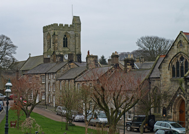
THE TOWN OF ROTHBURY
ROTHBURY is a township and market town in the parish of the same name, comprising an area of 4,923 acres, of which the rateable value is £2,410 7s. 6d. The number of its inhabitants in 1801, was 668; in 1811, 763 ; in 1821, 891; in 1831; 1,014 ; in 1841, 881; and 1851, 895 souls. Lord of the manor, the Duke of Northumberland. Subsequent to the Conquest, Rothbury was a large manor, and though it had the manors of Thropton and Sincher annexed, yet, of itself, it formed a member of the barony of Warkworth. Robert Fitz Roger was infeoffed by King John, of the manor of Rothbury, which at that period was the property of Robert de Cramaville. The same monarch also granted a charter by which liberty was given to hold a market here every Tuesday, and also an annual fair, commencing on the feast of St. Matthew, and to continue for three days, with all the rights, duties, customs, tolls, &c. belonging to a fair, and also a free forest, with all liberties, franchises and privileges. In consequence of the failure of heirs male, this manor reverted to the crown, and in the reign of Ed ward III., it was granted by that monarch to Henry Percy and his heirs, with whom it continued till the attainder of Henry, Earl of Northumberland, in the reign of Edward lV., when it was given to Sir Robert, afterwards Lord Ogle, to hold for his life, after which it again became the property of the Percies ; but, though the Duke of Northumberland is lord Of the manor, he possesses very little property in the town, and claims only one-sixteenth part of the common. There are many small enclosures of fine productive land, which once belonged to the common, on the east side of the town. The right of these was resigned by the lord of the manor, in lieu of a right of pasture in Rothbury Forest, held by common.
THE TOWN of Rothbury is delightfu1ly situated in a sequestered and romantic glen, sheltered by a lofty ridge of rocks, on the north side of the river Coquet, which is here crossed by an excellent stone bridge of four arches. It is distant twelve miles south-west from Alnwick, and fifteen miles north-west from Morpeth. A small market is held here on Fridays, and fairs for horned cattle, linen and woollen cloth, on the Friclay in Easter-week, Whit-Monday, October 2nd, and All-Saints' Day.
THE CHURCH, dedicated to All-Saints, is a handsome edifice, in the early English style of architecture, erected, upon the site of the ancient church, in the year 1850, at a cost of £3,000, and consists of a nave, chancel, aisles, and a square embattled tower. The nave is spacious and lofty, and is furnished with low open seats or benches, containing 700 free sittings. The font is a handsome stone structure bearing the date 1664, but the pedestal, which is ornamented with carved niches, and figures, appears to be much older. The living, a rectory in the archdeaconry of Lindisfarne and deanery of Rothbury, is valued in the Liber Regis at £58 6s. 8d. ; gross income, £1,133. Patron, the Bishop of Carlisle; rector, Rev. C. G. Hurcourt; curate, Rev. Thomas B. Simpson.
The Independents have a commodious chapel here in connexion with the Durham and Northumberland Association of Congregational Churches and Ministers. It was erected in 1842, and will accommodate about 300 persons. There is a school attached to this chapel.
ROTHBURY GRAMMAR SCHOOL, situated near the church, was founded in accordance with the will of the Rev. J. Tomlinson, in 1719, and further endowed by the will of George Fletcher, in 1710. The Archdeacon of Northumberland, and the Rectors of Rothbury and Elsdon are the patrons, and have the right of appointing the master, who is bound to instruct all the boys of the parish, who apply, in reading, writing, and accounts, and the rudiments of Latin and Greek, when required. Rev. F. Bainbridge, head master.
ROTHBURY GIRLS' SCHOOL is supported from the charities of Tomlinson and others, and the mistress is bound to teach as many girls of the parish as apply, reading, writing, and accounts, free, but they pay for instruction in needlework.
THE MECHANICS' INSTITUTION was established in 1850, and its library now contains about 400 volumes, on general history, science, &c. The Rector of Rothbury is president of this institution ; the Rev. P. Bainbridge, treasurer; and Mr. Robert Graham, secretary and librarian.
THE ROTHBURY POOR LAW UNION comprises 71 parishes and townships, embracing an area of 159,168 acres, and its population, in 1851, was 7,431 souls. The parishes, or townships, are Alnham, Alwinton, Barrow, Bickerton, Biddleston, Brinkburn (High), Brinkburn (Low), Brinkburn (South), Burrowden, Caistron, Callaley and Yetlington, Cartington, Clennell, Coatyards, Debdon, Dueshill, Elsdon, Ewesley, Fallowlees, Fairhaugh, Fairnley, Farnham, Flotterton, Green Leighton, Harbottle, Hartington, Hartington Hall, Harwood, Healey and Combhill, Hepple, Hepple Demesne, Hesley Hurst, Hollinghill, Holystone, Kidland, Lee Ward, Linbridge, Linsheeles, Long Framlington, Lorbottle, Monkridge, Mount Healey, Netherton (North), Netherton (South), Newton, Nunnykirk, Paperhaugh, Peels, Prendwick, Raw, Ritton Colt Park, Ritton White House, Rothbury, Rothley, Ryle (Great), Ryle (Little), Screnwood, Sharperton, Snitter, Thropton, Todburn, Tosson (Great), Tosson (Little), Trewhitt, Unthank, Warton, Whittingham, Whitton, Wingates, Woodside, and Wreighill.
THE UNION WORKHOUSE is situated here. Robert Graham, governor of the workhouse and parish clerk.
OLD ROTHBURY occupies the summit of a lofty hill, north-west of the present town, and seems to have been, at one time, strongly entrenched.
CHARITIES. The Rev. John Tomlinson, rector of Rothbury, by his will, bearing date 12th February, 1719-20, gave to the rector and churchwardens of Rothbury and their successors, the lease lately purchased by him of John Fergy, of Todhills, and the estate which he had lately purchased of William Potts, in Harbottle, in the parish of Alwinton, and also the estate which he had lately purchased of George Burn, in Sharperton; and he directed that the yearly rents and profits of the said estates should be laid out in binding to trades and sending to the University such of the poor boys as they and the four and twenty should think deserving, and also in relieving poor housekeepers; he also gave to the churchwardens and four and twenty, and their successors, a rent charge of £20 per annum, issuing out of lands lying at Bickerton, lately bought by him of John Snowdon; and also the lease of a housestead which he held at Rothbury, of the Duke and Duchess of Somerset, with the house he had erected thereon, for a schoolmaster, and a school to teach the children in, and also £20 to finish the said schoolhouse, and he directed that £14 per annum and the house to live in, should go to the head master, and £6 per annum to the under master ; that the head master should be appointed after the decease of his executors, by the Archdeacon of Northumberland, the Rector of Rothbury, and the Rector of Elsdon, for the time being, respectively; and that such schoolmaster and under master should, in consideration of the salaries and other conveniences before-mentioned, teach gratis all such children within the said parish as should be sent to school for that purpose, to read and. to understand the English, Latin, and Greek tongues, and to write, cast accounts, and the church catechism. He also gave to his executor, thereafter mentioned, and tl1eir heirs, for ever, all his houses and lands in Alnwick, and all the estates lately purchased by him of the said William Potts, in Sharperton, with full power to sell and dispose of the same, and apply the money to charitable uses, according to their discretion. George Fletcher, who died in 1710, left a rent charge of £6 to the Grammar School of Rothbury, and William Hall, in 1779, gave to the ministers and churchwardens of Rothbury £120 on trust, to pay the same to the master of Caistron, Wreighill, Hepple, Flotterton, Warton, and Bickerton, to read English.
|
Anderson Alexander Bainbridge Rev. T .head-master, Grammar-School Bolam Eleanor, board and lodgings, Prospect-place Bonner George, farmer and coalowner, Path Head Brown Gilbert, saddler and harness maker Burn John, boot anfl shoemaker Carmichael Wm. farmer, Crag End Cocks Robt. superintendent constable for the west division of Coquetdale Ward Common Miss Rachel Crawford M. John Cummings John, butcher Cummings Thomas, butcher and vict. Star Inn Davy William, draper and grocer Davy William, joiner and cartwright Davy William, cooper Davison James, shopkeeper Davison John, draper and grocer Dickson Archibald, cooper Dickson Elizabeth, shopkeeper Dixon Mrs. Jane Dixon Henry, black and whitesmith Dores Thomas, vict, and slater, Queen's Head Inn Dores Mr. Robert Douglas Catherine, shopkeeper Elsdon Henry, joiner and builder Elsdon Thos. joiner and cartwright Farrage Robert, chemist and druggist, and postmaster Farrage John, boot and shoemaker Fife William, Esq. Frater David, joiner and cartwright Hay Robert, baker and flour dealer Graham Robert, governor of the workhouse, and parish clerk Hall William, joiner Hedley Wm. tin-plate worker Henderson William, stonemason & builder Henderson Ellen, milliner Hopper John, relieving officer and registrar of births, marriages, and deaths, for the Rothbury Union Humble George, boot and shoemaker Hudson Joseph, blacksmith |
Humble Mary, shopkeeper Hunter George, saddler and harness maker Hunter William, shoemaker Lawson William, vict, Three Half Moons Mackey James, tailor Mavin Robert, hairdresser Mitchison Hannah, vict. Turk's Head Moir Rev. David, (Independent) Murray -,draper and grocer Murray William, watch and clockmaker Nichol Mary, milliner Potts David, buker and flour dealer Potts William Henry, surgeon Robinson Elizabeth, shopkeeper Ronaldson James T. agent, Rothbury Brewery Scott Matthew, vict. and fanner, Black Bull Selby George, boot and shoemaker Selby Mary, bonnet maker Simpson Rev. Thomas Burne, M.A. curate Shotton William, farmer Shotton Thomas and John, saddlers Shotton Isabella, vict. Blue Bell Smith James, vict. and weaver, Rifleman Snowden John, shopkeeper Storey Edward, freeholder, Knoglow Storey George & Co. brewers, malsters, and spirit merchants, Rothbury Brewery Storey James, draper and grocer Storey John, blacksmith and horse-shoer Storey John, freeholder, Blue Knox Summers Eustace C. surgeon Thompson Robert, chemist and druggist Temple Ephraim, clerk Todd Mary, day school Todd John, surgeon and medical attendant for the workhouse Turner Wiiliam, vict. and joiner, Sun Watson John, Sexton Watson Thomas, boot and shoemaker Watson William, plumber and glazier White and Hall, woollen manufacturers, Debdon Fulling Mill Young Alexander |
CARRIER TO NEWCASTLE. Waiter Ramsay, on Wednesday
SNITTER is a township and village the property of the Duke of Northumberland, Audrew Gillon, Esq., Matthew Bell, Esq., Mr. Thomas Ord, and several freeholders. There are many townships which still pay a quit rent to this, viz.: Little Tosson six shillings, Warton thirteen shillings and four-pence, Plane Field Farm, six shillings and eightpence, Camp Ville, in Holystone, twenty shillings, with other places. The Duke of Northumberland is lord of the manor. The area of the township is 1,083 acres, and its rateable value £1,325 10s. Population in 1801, 173, in 1811, 158; in 1821, 160; in 1831, 165; in 184, 163; and in 1851, 173 souls. THE VILLAGE of Snitter is situated three miles north-west by west of Rothbury. Here is a school in connexion with the Rothbury Grammar School, and receives £5 per annum from the same charities.
|
Armstrong Andrew, shopkeeper Amery Ann, shopkeeper Brown John, vict. Blue Bell Lisle George, shopkeeper Mennum James, vict. Half Moon Morpeth Robert, miller, Snitter Hill Ricalton James, schoolmaster Tillie Mary, shopkeeper |
Witherson Robert, tailor
Farmers Liddell James, and Overseer Ord Thomas, and yeoman Pringle Edward, and yeoman Redhead William Storey Matthew, and yeornan, Snitter Lane |
THROPTON is a township and village comprising 827 acres, and its rateable value is £1,394 16s. The number of its inhabitants in 1801, was 118; in 1811, 148; in l 821, 158; in 1831, 218; in 1841, 257; and in 1851, 248 souls. THE VILLAGE of Thropton is situated near the confluence of the Snifter-burn and the Coquet two miles west by north of Rothbury. Here is a very neat Catholic Church dedicated to All Saints. It was enlarged in 1842 by the Rev. Dr. Corless, and is now a fine commodious structure. Rev. James Hubbersty, priest. There is a school attached to this church. The English Presbyterians have a commodious chapel here, which was erected in 1799, and will accommodate about 300 persons. Rev. David S. Ferguss minister;
|
Clark John, tailor Common Catherine, shopkeeper Crow Mr. William Dixon Alice, shopkeeper Dodds Mrs. Alice Douglas John, butcher Douglas William, shopkeeper Fergus Rev. David S. (Presbyterian) Forster Jane, shopkeeper Hodgson James, shopkeeper Hubbersty Rev. James (Catholic) Hunter John, boot and shoemaker Moore Nicholas, shopkeeper Mowitt grocer and draper Paulin George, millwright Riddell Mrs. Dorothy |
Riddell John, cattle dealer Riddell William. vict. and farmer, Three Wheat Sheafs Robson Andrew, joiner Selby George-, butcher Selby Mr. William Smith George, schoolmaster Storey William, tailor Watson William, tailor Wintrip Robert, cartwright Wood Thomas, blacksmith
Farmers Bell William, and yeoman Black Ralph Dixon William and John, and overseers, Westfield House Green Robert, and yeoman |
CARRIERS.-William Douglas, to Newcastle, on Wednesday; and James Hodgson, to Alnwick, on Saturday
TOSSON (GREAT) AND RYEHILL form a township and hamlet 'Comprising an area of 2,760 acres, the property of William Ord, Esq., Captain Ilderton, the Rev. Mr. Hewit, and others. The rateable value is £1,078, and its population in 1801, was 150; in 1811, 119; in 1821, 159; in 1831, 195; in 1841, 178; and in 1851, 138 souls. THE HAMLET of Great Tosson is situated one mile and three-quarters W.S.W. of Rothbury, and appears to have been a much larger place in former times. Here is a tower of considerable antiquity, and a Roman camp the entrenchments of which are still visible. RYEHlLL, in this township, consists of two farms, which occupy an eminence commanding a rich and varied prospect of the surrounding country. At Great Tosson there is a woollen manufactory, a corn mill, and some excellent limestone quarries.
DIRECTORY. John Ashton, woollen manufacturer; John Carr, blacksmith and farmer; Thomas Rutherford, farm-steward; John and William Tunnah, corn millers and farmers; and the farmers are John Hall, Volvershield, Nicholas and William Moor, Hyebill, and George Turnbull, Great Tosson.
TOSSON (LITTLE) township is situated two and a half miles west of Hothbury. It contains 518 acres, the property of Percival Clennell, Esq., and the rateable value is £473. Population in 1801, 34; in 1811, 27; in 1821, 36; in 1831, 29; in 1841, 31; and in 1851, 30 souls. It is in the occupancy of Joseph Howey, farmer.
TREWHITT (HIGH AND LOW) form a township containing 1,653 acres. The principal proprietors are Adam Atkinson, Esq. Andrew Gillon, Esq., and William Lynn Smart, Esq. The rateable value is £1,680 6s., and the population in 1801, was 94; in 1811, 110; in 1821, 117; in 1831, 137; in 1841, 130; and in 1851, 116 souls. The soil in this township is principally a strong clay, though in some places it is a deep loam. It was formerly crossed by a Roman road vestiges of which are still visible. The late Mr. Smart traced its course from this township to Cumberland. The two hamlets of High and Low Trewhitt. are situated about four miles north-west of Rothbury. TREWHITT HOUSE is in the vicinity of High Trewhitt, and is at present occupied by a steward. This township was formerly the property of the Widdringtons, and was afterwards possessed by the Claverings.
DIRECTORY. John C. Bolam, farmer; James Brown, farmer and overseer, High Trewhitt, George Carr, blacksmith and agricultural implement maker; George Jennison, farmer, The Demesne; and John Swan, joiner and cartwright.
WARTON is a township and hamlet, the property of William Trotter, Esq., and Gideon Spearman, Esq. The area of the township is 624 acres, and its rateable value is £935. The number of its inhabitants in 1801, was 66, in 1811, 41; in 1821, 46; in 1831, 59; in 1841, 74; and in 1851, 59 souls. The soil here is remarkable for its fertility. Warton was formerly a member of the barony of Hepple, and its warlike inhabitants were long the terror of the Scottish borders. THE HAMLET of Warton is situated three miles west by north of Rothbury.
DIRECTORY. Mark Clark, farm-steward; Gideon Watson, High Warton; and John Wintrop, joiner and cartwright.
WHITTON is a township and hamlet, the property of A. R. Fenwick, Esq, Mrs. Jane Weallans, and several freeholders. The area of the township is 674 acres, and its rateable value £821 6s. Population in 1801, 84; in 1811, 105; in 1821, 110; in 1831, 104; in 1841, 82 ; and in 1851, 46 souls. This manor was formerly the property of the Umfraville family, from whom it was transferred to the Percies, and subsequently became attached to the rectory of Rothbury. WHITTON TOWER, which has long been the residence of the rectors of Rothbury, was formerly a strong structure, and formed part of the range of towers, which extended from Hepple to Warkworth; it is now an elegant and commodious edifice, surrounded by thriving plantations.
LONGEVITY. Died, in 1823, Mrs. Isabella Burn, of this place, aged 104 years. Her grand-daughter, Miss Isabella Burn, is married to Mr. Thomas Ramsay, who conducts a respectable academy at Backworth, in Earsdon parish.
DIRECTORY. Rev. Charles G. V. N. Harcourt, canon of Carlisle and rector of Rothbury, The Tower ; .Mr. Thomas Riddell ; Miss Ann Weallens, Whitton
Cottage; and the farmers are John Graham, Whitton; Joseph Graham, Glebe Farm; and Edward Pyle, Hillhead.
WREIGHILL is a township and hamlet, containing 411 acres of land, the property of Mrs. Weallens, of Flotterton House, and its rateable value is £448. The number of its inhabitants in 1801, was 27; in 1811, 26; in 1821, 29; in 1831, 27; in 1841, 29; and in 1851, 17 souls. The soil in the northern parts of this township is incumbent upon freestone, and that in the southern parts rests upon limestone. The remains of a Roman Camp are still visible in this neighbourhood. THE HAMLET of Wreighill is situated five miles west by north of Rothbury. This township is farmed by the proprietor. John Scott, steward.