Topics > Northumberland > Civil Parishes in Northumberland > Bardon Mill Civil Parish > Hillfort and Roman signal station, Barcombe Hill
Hillfort and Roman signal station, Barcombe Hill
Scheduled Monument area - based on Historic England data (Open Government Licence).
The remains of an Iron Age defended settlement and Roman signal station are located on Barcombe Hill, about 2½ miles north of Bardon Mill in Northumberland. The Roman signal station was a short-lived, turf-and-timber watchtower built within the earlier Iron Age hillfort. It pre-dated Hadrian's Wall (c. late 1st Century AD). The signal post served as an observation post for the frontier, guarding the Stanegate road, and offering views towards Vindolanda (just under 1 mile WSW of the signal tower). The Iron Age hillfort and Roman signal station are visible as earthwork remains today. This is a Scheduled Monument (legally protected).

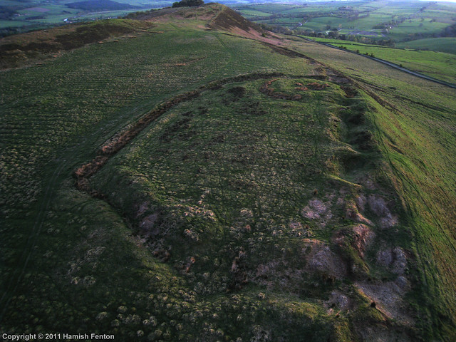
LIDAR - Image from opendata.hillforts.eu (CC-BY-SA), based on data from the Environment Agency - National LIDAR programme
Scheduled Monument (#1018536): Defended settlement and Roman signal station 410m south of West Crindledikes
Click the headings below to expand (selected extracts from the Historic England scheduling)
All Roman signal stations with surviving archaeological remains are considered to be nationally important. The defended settlement on Barcombe Hill is well preserved and retains significant archaeological deposits. It is one of a number of prehistoric monuments in the Hadrian's Wall corridor which, taken together, will add greatly to our knowledge and understanding of settlement and activity at this time. The importance of the monument is enhanced by the survival of a well preserved early Roman signal station within it.
The monument includes a defended settlement of Iron Age date and a signal station of Roman date, situated in a prominent location on the northern edge of Barcombe Hill.
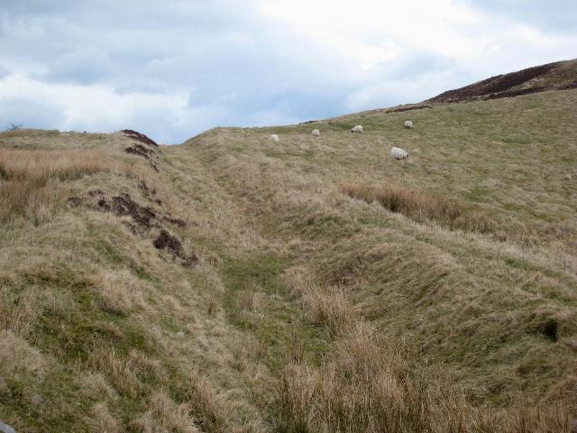
The defended settlement is visible as a roughly oval enclosure, 95m north east to south west by 42m north west to south east, within an inner and outer bank and a ditch. The stone and earth inner bank is up to 2m wide and is best preserved on the south and eastern sides. The surrounding ditch is on average 6m wide and 1m deep. Outside of the ditch there is a second bank on average 3m wide and standing to a maximum of 0.6m high where it is best preserved on the south side.
The northern side of the enclosure has been disturbed by a series of quarry holes thought to be Roman in date and associated with the construction of Hadrian's Wall. Within the north west corner of the enclosure there are the well preserved remains of a turf-built Roman signal station, visible as a roughly rectangular enclosure with rounded corners, 17m east to west by 13m north to south and standing to a maximum height of 0.8m. It is surrounded by a broad ditch on average 3m wide. Within the enclosure is a raised central platform, and the remains of at least one causeway giving access across the ditch is visible. The signal station was the subject of limited excavation in 1939 and again in the early 1950s; both excavations uncovered a limestone flagged base to the turf rampart measuring 4.2m wide which was cut into the rampart of the earlier defended settlement. The later excavation also recorded the discovery of a small oven with a stoke hole to the north east, a large amount of charcoal and Roman pottery of first century date. It is thought that the signal station pre-dated the construction of Hadrian's Wall and was only in use for a short time during the later first century AD.
EN0493 Barcombe Hill, Northumberland
Click the headings below to expand (selected extracts from the Atlas of Hillforts of Britain and Ireland)
Lying to the NE of Vindolanda on the northern edge of Barcombe Hill at 259m OD, a bivallate hillfort, later occupied by a Roman signal station. Approximately oval in form, measuring 95m NE-SW by 42m transversely enclosing 0.4ha. It is situated on level ground which slopes away steeply beyond the rampart in the NE. The ramparts are constructed of earth and stone, the inner rampart measuring up to 2m wide and the outer rampart 3m wide and 0.6 high separated by a ditch 6m wide and 1m deep. Today these are best preserved in the S and SE. Elsewhere they have been disturbed by Roman quarrying attributed to the construction of Hadrian's Wall but probably more widely exploited in the medieval and post medieval period. Quarry pits extend along the northern ditch and to the E and W for 450m. No entrance has been identified. In the NW corner of the hillfort are the remains of the turf-built signal station which survive up to a maximum of 0.8m and measure 17m E-W by 13m N-S surrounded by a 3m wide ditch. No other internal features are visible although excavations by Aitchison in 1939 and Crawford in 1950, primarily concerned with investigation of the signal station, exposed a limestone flagged base to the turf rampart 4.2m wide, which was cut into the hillfort rampart (Jobey 1969; Woodfield 1966). The 1950 excavation also revealed a small oven in the NE of the hillfort and large amounts of 1st century Roman pottery and charcoal. The signal station is thought to have pre-dated the construction of Hadrian's Wall and to have been short lived. Traces of ridge and furrow overlie the interior. The site is recorded on 1856-65 OS mapping. It is scheduled as a defended settlement and a Roman signal station.
Source: Lock, Gary and Ralston, Ian. 2024. Atlas of Hillforts of Britain and Ireland. Available at: https://hillforts.arch.ox.ac.uk (CC BY-SA 4.0)


from Flickr (flickr)
Roman Signal Station, Barcombe Hill, Bardon Mill, Northumberland [2]
Pinned by Simon Cotterill

from https://historicengland.org.u…
Defended settlement and Roman signal station 410m south of West Crindledikes - List Entry
- ....The monument includes a defended settlement of Iron Age date and a signal station of Roman date, situated in a prominent location on the northern edge of Barcombe Hill. The …
Added by
Simon Cotterill

from Flickr (flickr)
Roman Signal Station, Barcombe Hill, Bardon Mill, Northumberland [2]
Pinned by Simon Cotterill
from https://historicengland.org.u…
Defended settlement and Roman signal station 410m south of West Crindledikes - List Entry
- ....The monument includes a defended settlement of Iron Age date and a signal station of Roman date, situated in a prominent location on the northern edge of Barcombe Hill. The …
Added by
Simon Cotterill