Topics > Northumberland > Civil Parishes in Northumberland > Warkworth Civil Parish > Historic Buildings and Monuments in Warkworth CP
Historic Buildings and Monuments in Warkworth CP
Listed buildings and scheduled monuments in Warkworth Civil Parish, Northumberland, from the National Heritage List for England[1]. Use the Search (below) if looking for a specific building / monument.
| Structure | List No. | Grade | Built~ | Note |
|---|---|---|---|---|
| Low Buston medieval settlement, 231m south east of Low Buston Hall | 1006502 | n/a | Medieval | Low Buston.Scheduled Monument. |
| Cup and ring marked rock 430m north of Morwick Hall | 1014482 | n/a | Prehistoric | Scheduled Monument. |
| Warkworth Castle motte and bailey castle, tower keep castle and collegiate church | 1011649 | n/a | C12th | Scheduled Monument |
| St Mary Magdalene's medieval chapel and associated earthworks, 90m north of Mauldin | 1014744 | n/a | C13th | Scheduled Monument |
| Nos. 1 and 2, Dial Place | 1155106 | II | ||
| No. 1, Castle Terrace | 1371232 | II | ||
| No. 1, the Stanners | 1371222 | II | ||
| Nos. 10, 11 and 12, Bridge Street | 1154922 | II | ||
| No. 13, Dial Place | 1155198 | II | ||
| No. 14, Castle Street | 1041706 | II | ||
| No. 14, the Butts | 1303569 | II | ||
| No. 15, Bridge Street | 1041735 | II | ||
| Nos. 16 and 16a, Castle Street | 1371231 | II | ||
| No. 16, Dial Place | 1041712 | II | ||
| No. 19, Dial Place | 1371234 | II | ||
| No. 20, Dial Place | 1041716 | II | ||
| No. 21, Bridge Street | 1041736 | II | ||
| Nos. 25 and 26, Castle Street | 1371208 | II | ||
| 3 Stone Coffins to East of South Aisle of Church of St Lawrence | 1303427 | II | Medieval | |
| Nos. 30 and 31, Castle Street | 1041740 | II | ||
| No. 33, Castle Street | 1041741 | II | ||
| No. 37, Castle Street | 1154988 | II | ||
| No. 4, Castle Street | 1371228 | II | ||
| No. 4, Dial Place | 1155178 | II | ||
| No. 43, Castle Street | 1303578 | II | ||
| No. 44, Castle Street | 1041700 | II | ||
| No. 46, Castle Street | 1371227 | II | ||
| No. 47, Castle Street | 1041701 | II | ||
| No. 4a, Castle Street | 1041703 | II | ||
| No. 5, Castle Street | 1371229 | II | ||
| No. 5a, Castle Street | 1041705 | II | ||
| Nos. 6 and 7, Dial Place | 1041710 | II | ||
| No. 6, Castle Street | 1371230 | II | ||
| Barclays Bank | 1041707 | II | C19th | Castle Street, Warkworh |
| Barn 30 Metres North East of Morwick Hall | 1155355 | II | Morwick | |
| Birling Manor | 1371205 | II | ||
| Bridge End House | 1041733 | II | ||
| Bridge Head Tower | 1154927 | II | C14th | Warkworth, Old Bridge / Bridge Street |
| British Rail East Coast Main Line Viaduct over River | 1371134 | II | ||
| Bullock and Fawcus Tombs 6 Metres South of South of Church of St Lawrence | 1041714 | II | ||
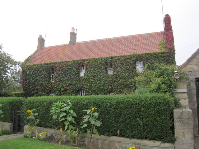
| Buston Barns Farmhouse | 1155307 | II | C17th | Low Buston |
| Butlesdon House | 1371235 | II | ||
| Cartshed Range on South of Yard | 1041693 | II | ||
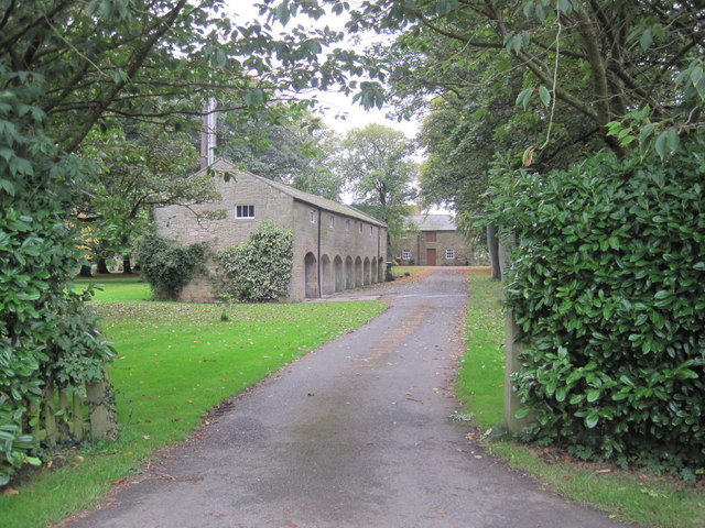
| Cartshed/Granary 60 Metres North of Low Buston Hall | 1041718 | II | C19th | Low Buston |
| Cartshed/Granary to North of Northfield Farmhouse | 1371259 | II | ||
| Warkworth Castle - Castle Curtain Walls with Gateway, Towers and Attached Buildings | 1041690 | I | C12th | |
| Castlegate House | 1041702 | II | ||
| Cemetery Chapel | 1041691 | II | ||
| Church of St Lawrence | 1303446 | I | 1132 | On the site of an Anglo Saxon church |
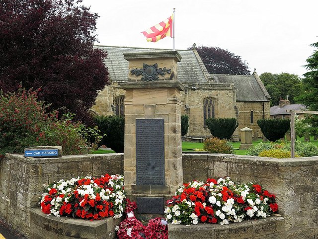
| Churchyard Walls, Gate and War Memorial | 1303431 | II | 1920 | Warkworth War Memorial |
| Co-Operative Shop | 1155282 | II | ||
| Coach House and Stable to Rear of Number 5 | 1041704 | II | ||
| Coach House Range to West of Birling Manor | 1041729 | II | ||
| Coach House, Outbuilding, Yard Walls and Gatepiers North East of Southside Farmhouse | 1303340 | II | ||
| Coquet House | 1041738 | II | ||
| Coquet Lodge | 1155662 | II | ||
| Coquet Lodge Cottages | 1041692 | II | ||
| Coquet View | 1154958 | II | ||
| Detached Byre 50 Metres North of Sturton Grange Farmhouse | 1041689 | II | Sturton Grange | |
| Dodsworth Tomb 14 Metres North East of South Churchyard Gate | 1041715 | II | ||
| Dorothy Boutique | 1154982 | II | ||
| Farmbuilding Group North West of Northfield Farmhouse | 1041683 | II | ||
| Farmbuilding Group to North of Southside Farmhouse | 1041686 | II | ||
| Forecourt Wall, Railings and Gates to Bridge End House | 1303592 | II* | ||
| Front Wall and Gate Piers to United Reformed Church | 1154978 | II | ||
| Front Wall and Gate Screen | 1041713 | II | ||
| Garden Wall and Gates to Emberside House | 1371206 | II | ||
| Garden Wall to East South and West of New Barns Farmhouse | 1041682 | II | ||
| Garden Wall to North of Emberside and Elm House | 1154913 | II | ||
| Garden Wall to North West of Sturton Grange Farmhouse | 1303282 | II | Sturton Grange | |
| Garden Wall to Number 1 | 1041687 | II | ||
| Garden Walls 100 Metres West of Shortridge Hall | 1041685 | II | ||
| Garden Walls to East of Morwick Hall | 1371237 | II | Morwick | |
| Garden Walls to Rear of Bridge End House | 1041734 | II | ||
| Garden Walls to West and South West of Southside Farmhouse | 1371221 | II | ||
| Gate Screen 80 Metres South West of Morwick Hall | 1371256 | II | Morwick | |
| Gate Screen at Drive Entrance 220 Metres South of Morwick Hall | 1041680 | II | Morwick | |
| Gatepiers, Quadrant Wall and Mounting Block to North of Gloster Hill Farmhouse | 1155296 | II | ||
| Grey Monument in Garden 100 Metres East of Morwick Hall | 1041720 | II | Morwick | |
| Ha-Ha Wall to South of Morwick Hall | 1041679 | II | Morwick | |
| Hen House and Attached Structures to North West of Birling Manor | 1303611 | II | ||
| Hulne House | 1371209 | II | ||
| J V Hall, Newsagent and Post Office | 1154986 | II | ||
| K6 Telephone Kiosk 10 Metres South of Pant Outside Number 19 | 1041708 | II | ||
| Lodge and Gatepiers 80 Metres North East of Southside Farmhouse | 1155509 | II | ||
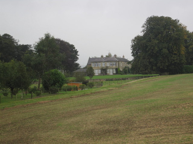
| Low Buston Hall | 1155303 | II | C17th | Low Buston |
| Market Cross | 1303500 | II | 1706 | Warkworth, Castle Street |
| Masons Arms | 1371233 | II | ||
| Morwick Hall and Attached Wall to North West | 1155337 | II | Morwick | |
| New Barns Farmhouse | 1041681 | II | ||
| Northfield Farmhouse | 1371258 | II | ||
| Number 8 and Attached Outbuilding | 1041731 | II | ||
| Old Barns Farmhouse | 1371257 | II | ||
| Old Gate Piers to East of Gloster Hill Farmhouse | 1041717 | II | C17th | Gloster Hill |
| Old Smithy 200 Metres East of Sturton Grange Farmhouse | 1155548 | II | Sturton Grange | |
| Outbuildings and Gate Piers to North of Sturton Grange Farmhouse | 1041688 | II | Sturton Grange | |
| Outbuildings at Rear of Numbers 4 and 5 | 1154909 | II | ||
| Outbuildings on North and East of Rear Courtyard with Attached Wall on West | 1041719 | II | ||
| Pant Outside Number 19 | 1303536 | II | ||
| Pill Box at NU233032 | 1372340 | II | 1940 | South of Morwick |
| Pill Box at NU250047 | 1052199 | II | 1940 | Between Gloster Hill and Warkworth |
| Pill Box at NU250063 | 1372339 | II | ||
| Shortridge Hall | 1303334 | II | ||
| Southside Farmhouse | 1303337 | II | ||
| Stable Range and Kennels on North of Yard | 1155678 | II | ||
| Stone Coffin and Lid Flanking Path 10 Metres South of Grey Monument | 1371255 | II | ||
| Sturton Grange Farmhouse | 1155517 | II | Sturton Grange | |
| The Barn | 1155040 | II | ||
| The Donjon | 1303256 | I | C15th | Warkworth Castle - Keep |
| The Hermitage Inn | 1041739 | II | ||
| The Horseless Carriage | 1041730 | II | ||
| The Old School | 1041737 | II | 1824 | Warkworth, The Butts |
| The Old Smithy | 1155049 | II | ||
| The Old Vicarage | 1155207 | II | ||
| The Schoolhouse | 1154948 | II | 1736 | Warkworth, The Butts |
| The Sun Hotel | 1155096 | II | ||
| The Vicarage | 1041711 | II | ||
| United Reform Church | 1371207 | II | ||
| Wall and Railings Enclosing Lawn in Front of Sun Hotel | 1041709 | II | ||
| Walls and Gatepiers to Warkworth Station | 1303237 | II | ||
| Warkworth Bridge | 1041732 | II | C14th | Over the River Coquet. Scheduled Monument(1020741) |
| Warkworth Hermitage | 1041684 | I | C14th | Scheduled Monument(1011648) |
| Warkworth House Hotel | 1154938 | II* | ||
| Warkworth Station | 1041694 | II | ||
| West Part of Farmbuilding Group to North of Maudlin Farmhouse | 1371236 | II | ||
| Warkworth Conservation Area | - | n/a | - | Conservation Area |
Primary source: the National Heritage List for England - NHLE is the register of nationally protected historic buildings and sites in England, including listed buildings, scheduled monuments, protected wrecks, registered parks and gardens, and battlefields. The list is maintained by Historic England. Check NHLE for updates and new entries. Secondary sources: British Listed Buildings and Keys to the Past.
Co-Curate Page
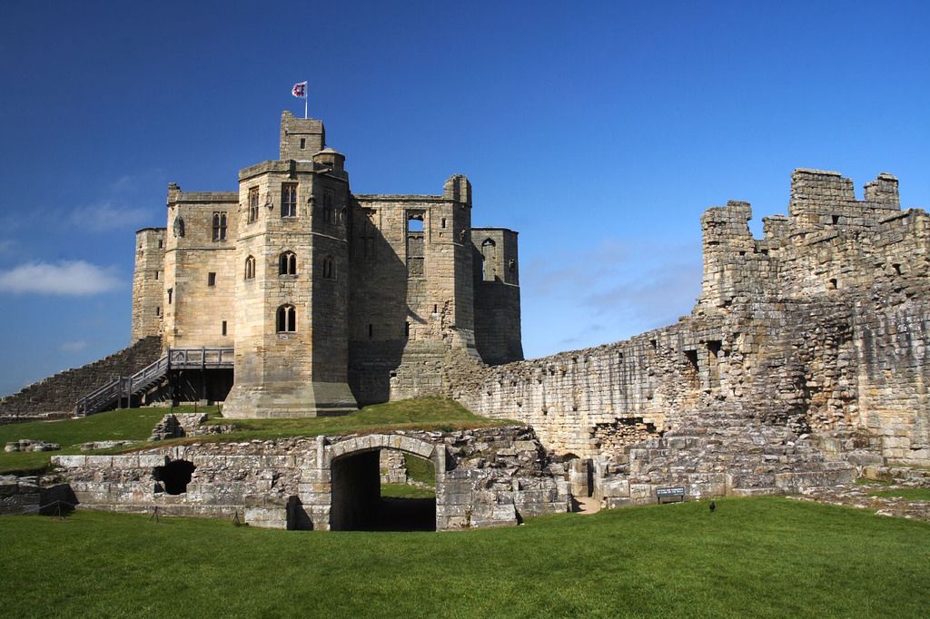
Warkworth Castle
- Overview About Warkworth Castle Map Street View Warkworth Castle is a well preserved medieval castle which is cared for by English Heritage. The castle is located by a loop in …
Co-Curate Page
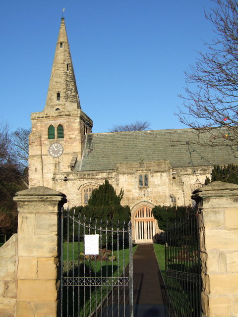
Church of St Lawrence, Warkworth
- Overview About the Church Map Street View The Church of St Lawrence in Warkworth, Northumberland is a Norman church which was built from 1132. It replaced an earlier Anglo-Saxon church from …
Co-Curate Page
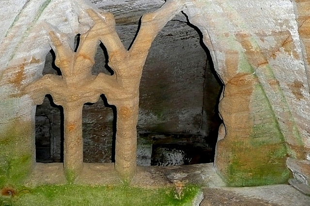
Warkworth Hermitage
- Overview Further Information Map "The Hermitage is reached by boat across the river Coquet. It was almost certainly established in about 1400 by the 1st Earl. Rather than a secluded …
Co-Curate Page
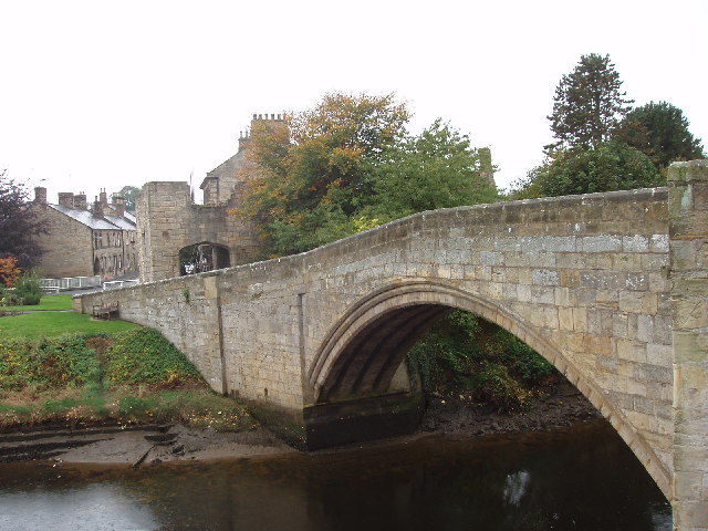
Warkworth Old Bridge
- The old stone bridge over the River Coquet at Warkworth dates from c.1380. John Cook of Newcastle, who died in 1378/9, bequeathed 20 marks towards the building of the bridge.[1] …
Co-Curate Page
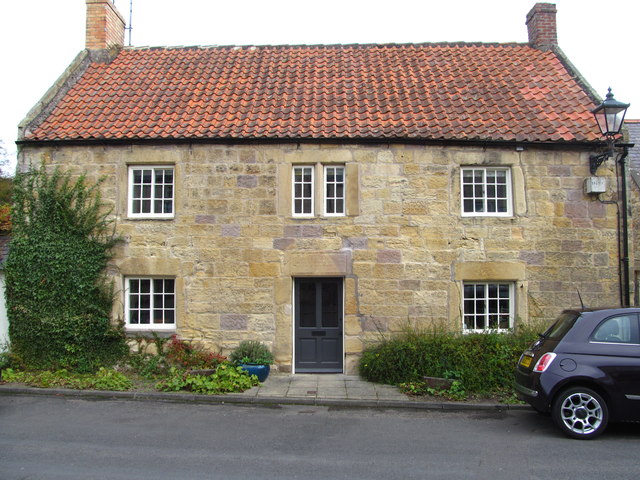
Buston Barns Farmhouse
- Overview Map Street View The farmhouse in the hamlet of Buston Barnes in Northumberland dates from the late 17th century, incorporating materials of an earlier structure, and is Grade II …
Co-Curate Page
Low Buston Hall
- Overview Map Street View Low Buston Hall is a substantial country house in the hamlet of Low Buston, near Warkworth. It's south wing was built in the 17th century. The …
Co-Curate Page
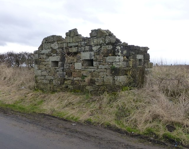
Cart-shed and granary, Low Buston
- Overview Map Street View The former cartshed and granary, 60 metres north of Low Buston Hall, was built in the early 19th century. It is Grade II listed on the …
Co-Curate Page
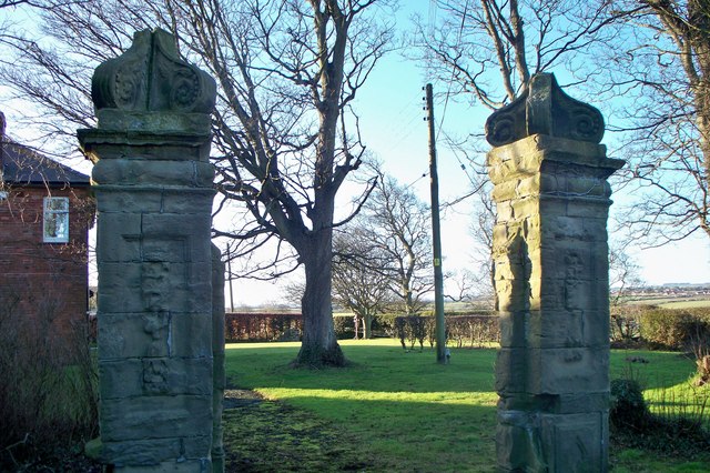
Old Gate Piers, Gloster Hill
- Overview Map Street View This was the main entrance to Gloster Hill, a substantial C17 house demolished in 1939; many architectural features were re-used at Dunstan Hall.[1] The gate piers …
Co-Curate Page
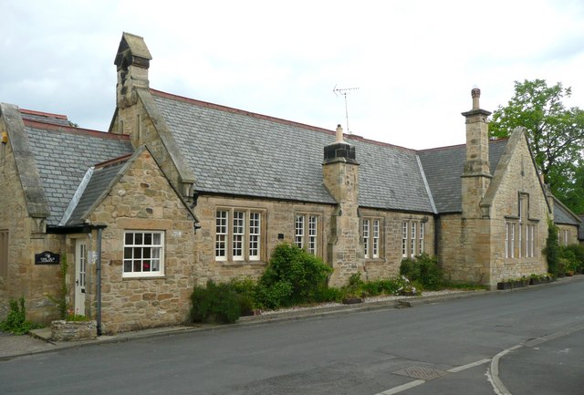
Old School, Warkworth
- Overview Map Street View Old School East and Old School West are residences located on The Butts in Warkworth. They are a former National School, which was founded in 1824, …
Co-Curate Page
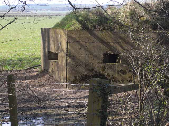
Pillbox, Morwick
- There is a pillbox near Morwick Farm, which was built in 1940 as part of the 'Coquet Stop Line'. The pillbox is Grade II listed on the National Heritage List …
Co-Curate Page
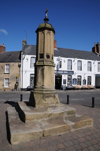
Market Cross, Warkworth
- Overview Map Street View The Market Cross in Warkworth is located on Castle Street, at the junction with Dial Place. It's stepped base probably survives from 1706. The upper part of …
Co-Curate Page
The Old School House, Warkworth
- Overview Map Street View The Old School House is located on The Butts in Warkworth. This is a former Borough School, dated 1736. Above the door, there is a panel …
Co-Curate Page
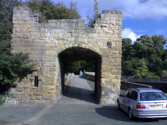
Bridge-Head Tower, Warkworth
- The Bridge-Head Tower is a 14th century gate tower at the south end of Warkworth Bridge. It is located on the west side of Bridge Street in Warkworth. The gate …

Co-Curate Page
Warkworth Castle
- Overview About Warkworth Castle Map Street View Warkworth Castle is a well preserved medieval castle which is cared for by English Heritage. The castle is located by a loop in …
Co-Curate Page
Church of St Lawrence, Warkworth
- Overview About the Church Map Street View The Church of St Lawrence in Warkworth, Northumberland is a Norman church which was built from 1132. It replaced an earlier Anglo-Saxon church from …
Co-Curate Page
Warkworth Hermitage
- Overview Further Information Map "The Hermitage is reached by boat across the river Coquet. It was almost certainly established in about 1400 by the 1st Earl. Rather than a secluded …
Co-Curate Page
Warkworth Old Bridge
- The old stone bridge over the River Coquet at Warkworth dates from c.1380. John Cook of Newcastle, who died in 1378/9, bequeathed 20 marks towards the building of the bridge.[1] …
Co-Curate Page
Buston Barns Farmhouse
- Overview Map Street View The farmhouse in the hamlet of Buston Barnes in Northumberland dates from the late 17th century, incorporating materials of an earlier structure, and is Grade II …
Co-Curate Page
Low Buston Hall
- Overview Map Street View Low Buston Hall is a substantial country house in the hamlet of Low Buston, near Warkworth. It's south wing was built in the 17th century. The …
Co-Curate Page
Cart-shed and granary, Low Buston
- Overview Map Street View The former cartshed and granary, 60 metres north of Low Buston Hall, was built in the early 19th century. It is Grade II listed on the …
Co-Curate Page
Old Gate Piers, Gloster Hill
- Overview Map Street View This was the main entrance to Gloster Hill, a substantial C17 house demolished in 1939; many architectural features were re-used at Dunstan Hall.[1] The gate piers …
Co-Curate Page
Old School, Warkworth
- Overview Map Street View Old School East and Old School West are residences located on The Butts in Warkworth. They are a former National School, which was founded in 1824, …
Co-Curate Page
Pillbox, Morwick
- There is a pillbox near Morwick Farm, which was built in 1940 as part of the 'Coquet Stop Line'. The pillbox is Grade II listed on the National Heritage List …
Co-Curate Page
Market Cross, Warkworth
- Overview Map Street View The Market Cross in Warkworth is located on Castle Street, at the junction with Dial Place. It's stepped base probably survives from 1706. The upper part of …
Co-Curate Page
The Old School House, Warkworth
- Overview Map Street View The Old School House is located on The Butts in Warkworth. This is a former Borough School, dated 1736. Above the door, there is a panel …

