Topics > Northumberland > Civil Parishes in Northumberland > Longhorsley Civil Parish > Historic Buildings and Monuments in Longhorsley Civil Parish
Historic Buildings and Monuments in Longhorsley Civil Parish
Listed buildings and scheduled monuments in Longhorsley Civil Parish, Northumberland, from the National Heritage List for England[1]. Use the Search (below) if looking for a specific building / monument.
| Structure | List No. | Grade | Built~ | Notes |
|---|---|---|---|---|
| Barn with Adjacent Gingang 60 Metres South of Paxton Dene Farmhouse | 1042893 | II | C19th | Paxton Dene Farm, Longhorsley |
| Blackpool Farmhouse | 1153594 | II | 1735 | |
| Church of St Helen | 1153608 | II | 1848 | Longhorsley. Porch from previous church of 1783. |
| Church of St Thomas of Canterbury (RC) | 1153619 | II | 1841 | Longhorsley |
| Forecourt Walls to North and West of Horsley Tower | 1153628 | II | C16th | With later alterations |
| Former Parish Church of St Helen | 1370652 | II | 1783 | Longhorsley. On the site of an Anglo Saxon church. |
| Former Schoolmasters House and Old Schoolroom | 1042096 | II | C17th | Longhorsley. |
| Garden Wall, Railings and Gate 120 Metres North-East of Linden Hall | 1042095 | II | C19th | Linden Hall |
| Garden Wall, Railings, Piers and Gate South of Muckley Farmhouse | 1042093 | II | C19th | |
| Garden Walls with Outbuildings at the Old Vicarage | 1042892 | II | C19th | |
| Ha-Ha Wall to South and East of Linden Hall | 1304218 | II | C19th | Linden Hall |
| Horsley Tower and Adjacent Outbuilding | 1042097 | II* | C16th | Longhorsley. Pele Tower |
| Linden Hall Hotel | 1304214 | II | 1813 | |
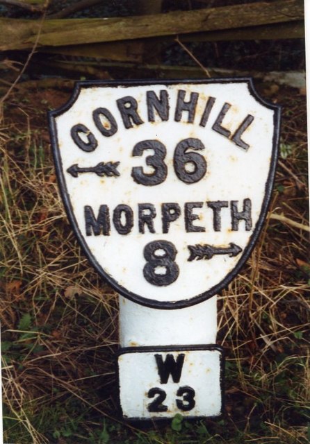
| Milepost at NGR NZ 1429667 | 1042090 | II | C20th | A697, near Linden Hall |
| Milepost at NGR NZ 14669510 | 1153590 | II | C20th | A697 |
| Milepost Beside Cottage by Drive to Whemleyburn | 1042091 | II | C20th | A697 |
| Milepost on East Side of Old Road Down to Weldon Bridge (Q.V.) | 1153582 | II | C20th | A697 |
| Muckley Farmhouse | 1042092 | II | c.1840 | Incorporating C18th fabric |
| Pill Box at NZ 139983 | 1370661 | II | 1940s | Weldon Bridge. WW2 pillbox |
| Stable Block North-East of Linden Hall | 1042094 | II | C19th | Linden Hall |
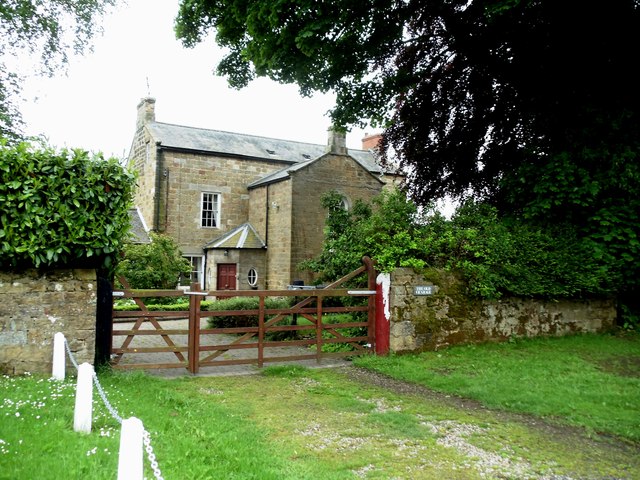
| The Old Vicarage | 1042098 | II | C19th | Longhorsley |
| Weldon Bridge, over River Coquet and Wall to North-West | 1370653 | I | 1760 | Weldon Bridge. Partly in Brinkburn CP. |
| Longhorsley Conservation Area | - | n/a | - | Conservation Area |
Primary source: the National Heritage List for England - NHLE is the register of nationally protected historic buildings and sites in England, including listed buildings, scheduled monuments, protected wrecks, registered parks and gardens, and battlefields. The list is maintained by Historic England. Check NHLE for updates and new entries. Secondary sources: British Listed Buildings and Keys to the Past.
Co-Curate Page
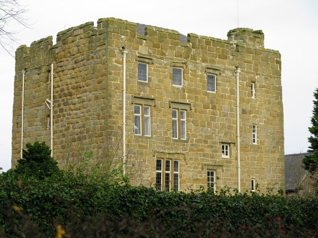
Horsley Tower
- Overview Street View The fortified towerhouse in Longhorsley was built by the Horsley family in the 16th century at a time when there were frequent boarder raids and hostilities with …
Co-Curate Page
Church of St.Thomas of Canterbury
- Overview Map St Thomas of Canterbury Church in Longhorseley was built in 1841. Before then the Roman Catholic parish was served by a chapel in Horsley Tower, which is located …
Co-Curate Page
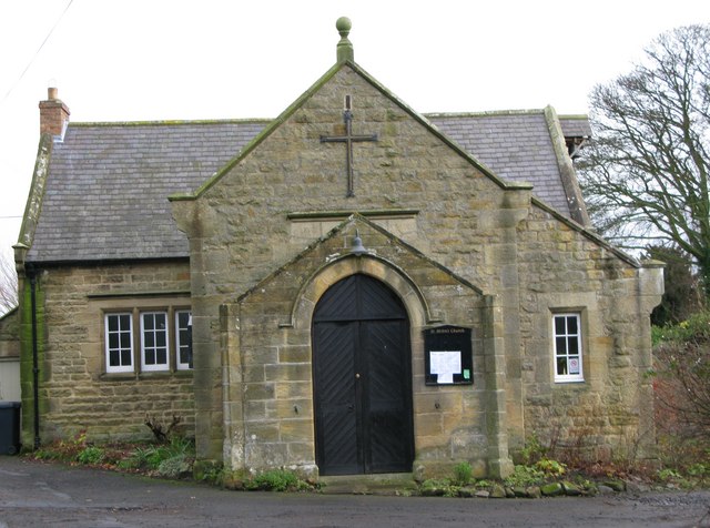
Church of St. Helen
- Overview Map Street View The current building of St Helen's Church on West Road in Longhorsley was the former village school, which was built in 1848. The school was converted …
Co-Curate Page
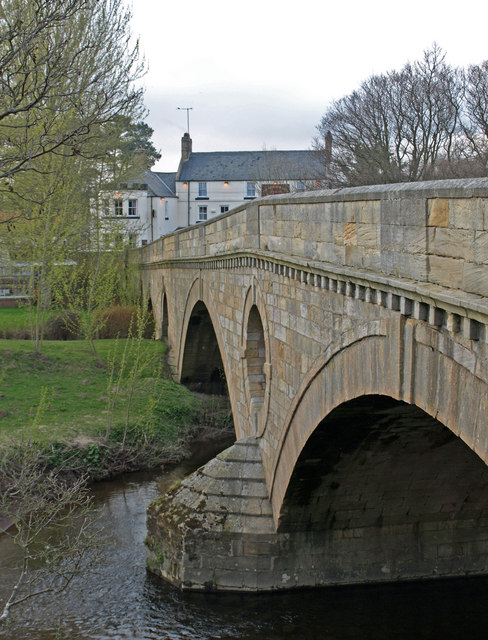
Weldon Bridge - Bridge
- Overview Map Street View The stone bridge over the River Coquet at Weldon Bridge was built c.1760[1] The bridge has 3 arches and distinctive circular openings between the arches. It …
Co-Curate Page
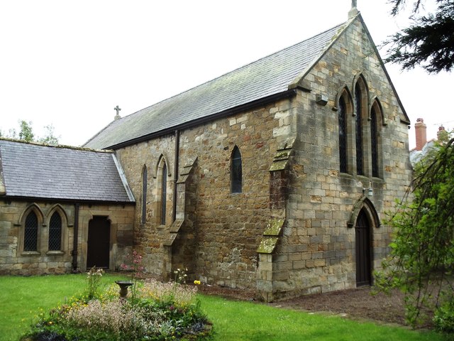
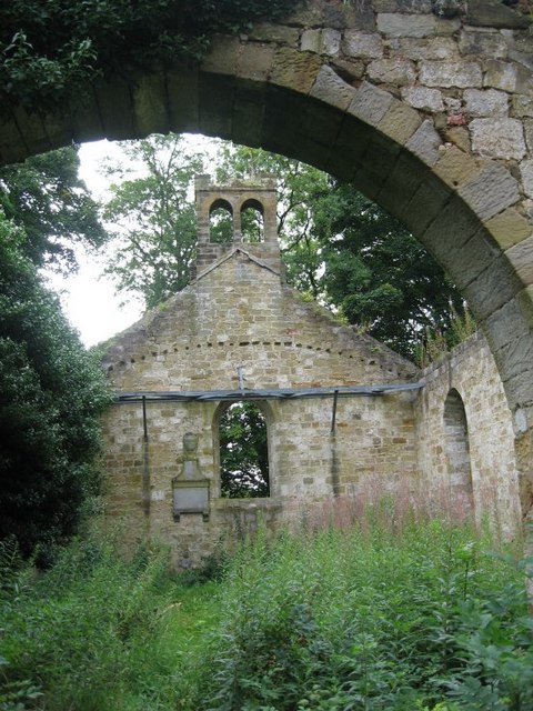
Former parish church of St. Helen
- Overview Map Aerial View The former parish church, located half a mile south of Longhorsley was rebuilt in 1783 on the foundations of a much older medieval building and on …
Co-Curate Page
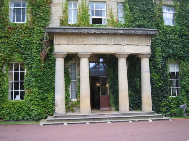
Linden Hall Hotel
- Overview About Map Linden Hall is located just over a mile to the north east of the village of Longhorsley in Northumberland. It was built as country house for Newcastle merchant …
Co-Curate Page
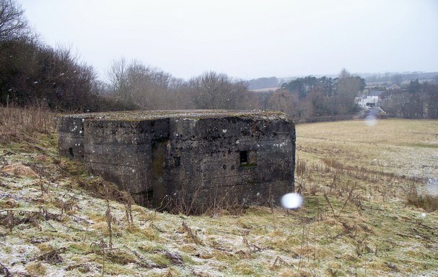
Pillbox, nr Weldon Bridge
- Overview Map Street View This large rectangular pillbox is located in a field, approximately a quarter mile south east of Weldon Bridge.
Co-Curate Page
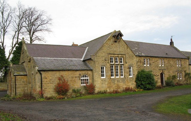
Old Schoolmaster's House and Schoolroom
- Overview Map Street View The former Schoolmaster's house and old schoolroom are adjacent to St Helen's Church in Longhorsley. The old school room is a single story building dating from …
Co-Curate Page
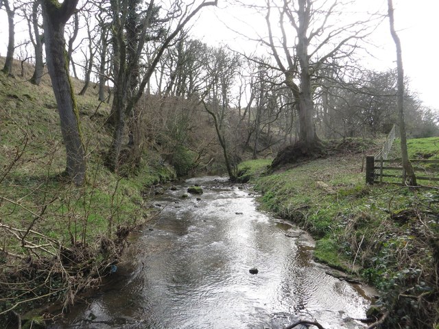
Paxton Dene & Burn, Longhorsley
- Overview Map Street View (Farm) Street View (Dean) Paxtondene Burn is a stream in Northumberland which flows the wooded Paxton Dene, close to Longhorsley. Paxton Dene Farm is located about a …
Co-Curate Page
Old Milepost on A697, near Linden Hall
- Overview Map There is an old milepost on the A697 by Bellamour, a short distance north of Linden Hall. The cast iron milepost is early 20th century made by Smith …
Co-Curate Page
The Old Vicarage, Longhorsley
- Overview Map Street View The Old Vicarage is located off the Village Green in Longhorsley. The former vicarage, near St Helen's Church, dates from the early 19th century. It is a Grade …

Co-Curate Page
Horsley Tower
- Overview Street View The fortified towerhouse in Longhorsley was built by the Horsley family in the 16th century at a time when there were frequent boarder raids and hostilities with …
Co-Curate Page
Church of St.Thomas of Canterbury
- Overview Map St Thomas of Canterbury Church in Longhorseley was built in 1841. Before then the Roman Catholic parish was served by a chapel in Horsley Tower, which is located …
Co-Curate Page
Church of St. Helen
- Overview Map Street View The current building of St Helen's Church on West Road in Longhorsley was the former village school, which was built in 1848. The school was converted …
Co-Curate Page
Weldon Bridge - Bridge
- Overview Map Street View The stone bridge over the River Coquet at Weldon Bridge was built c.1760[1] The bridge has 3 arches and distinctive circular openings between the arches. It …
Co-Curate Page
Former parish church of St. Helen
- Overview Map Aerial View The former parish church, located half a mile south of Longhorsley was rebuilt in 1783 on the foundations of a much older medieval building and on …
Co-Curate Page
Linden Hall Hotel
- Overview About Map Linden Hall is located just over a mile to the north east of the village of Longhorsley in Northumberland. It was built as country house for Newcastle merchant …
Co-Curate Page
Pillbox, nr Weldon Bridge
- Overview Map Street View This large rectangular pillbox is located in a field, approximately a quarter mile south east of Weldon Bridge.
Co-Curate Page
Old Schoolmaster's House and Schoolroom
- Overview Map Street View The former Schoolmaster's house and old schoolroom are adjacent to St Helen's Church in Longhorsley. The old school room is a single story building dating from …
Co-Curate Page
Paxton Dene & Burn, Longhorsley
- Overview Map Street View (Farm) Street View (Dean) Paxtondene Burn is a stream in Northumberland which flows the wooded Paxton Dene, close to Longhorsley. Paxton Dene Farm is located about a …
Co-Curate Page
Old Milepost on A697, near Linden Hall
- Overview Map There is an old milepost on the A697 by Bellamour, a short distance north of Linden Hall. The cast iron milepost is early 20th century made by Smith …
")

