Topics > Civil Parishes in Cumbria > Haverthwaite Civil Parish > Historic Buildings and Monuments in Backbarrow & Haverthwaite CP
Historic Buildings and Monuments in Backbarrow & Haverthwaite CP
Listed buildings and scheduled monuments in Backbarrow & Haverthwaite Civil Parish, Cumbria, from the National Heritage List for England[1]. Use the Search (below) if looking for a specific building / monument.
| Structure | List No. | Grade | Built~ | Notes |
|---|---|---|---|---|
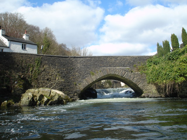
| Backbarrow Bridge | 1225413 | II | C17th | Backbarrow. Over the River Leven. |
| Bare Syke House | 1266370 | II | 1740s | |
| Bigland Hall | 1225412 | II | C16th | Remodelled and extended in 1809. |
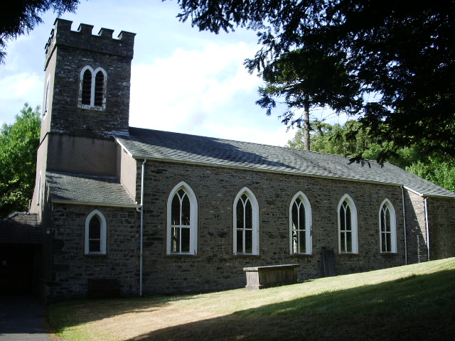
| Church of St Anne | 1225492 | II | 1825 | Haverthwaite |
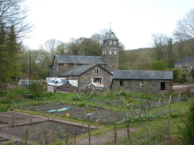
| Clock Tower Works | 1266371 | II* | 1849 | Low Wood |
| Gate Piers to Front of Haverthwaite House | 1266333 | II | c.1734 | |
| Hard Crag and Adjoining Barn and Outbuilding | 1266369 | II | C17th | |
| Haverthwaite House and Cottage | 1225414 | II | 1734 | |
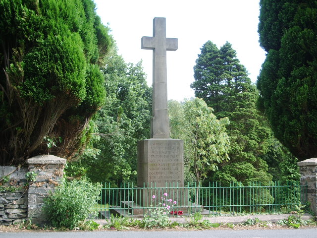
| Haverthwaite War Memorial | 1457206 | II | 1920 | |
| Low Wood Bridge | 1225415 | II | C18th | Low Wood |
| Lowwood gunpowder works | 1018134 | n/a | 1799 | Low Wood. Scheduled Monument |
| Backbarrow ironworks | 1007084 | n/a | 1711 | Backbarrow. Scheduled Monument |
Primary source: the National Heritage List for England - NHLE is the register of nationally protected historic buildings and sites in England, including listed buildings, scheduled monuments, protected wrecks, registered parks and gardens, and battlefields. The list is maintained by Historic England. Check NHLE for updates and new entries.
Secondary sources: British Listed Buildings.
Co-Curate Page
Church of St Anne, Haverthwaite
- Overview Map Street View St Anne's Church is located on Old Barrow Road in Haverthwaite. It was originally built in 1825 as a chapel of ease to Holy Trinity Church in …
Co-Curate Page
Low Wood Gunpowder Works
- Overview About Low Wood Gunpowder Works Map Street View The Low Wood Gunpowder Works, located on the east banks of the River Leven at Low Wood, were in operation from …
Co-Curate Page
War Memorial, Haverthwaite
- Overview Map Street View The war memorial for Haverthwaite is located at the edge of the village cemetery, overlooking Levis Garth (road). The memorial commemorates 15 local servicemen who lost …
Co-Curate Page
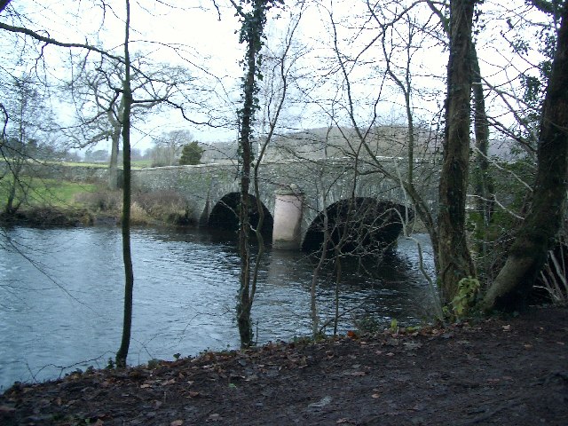
Backbarrow Bridge
- Overview Map Street View The bridge at Backbarrow carries the road over white water falls on the River Leven. The bridge dates from the late 17th or 18th century and …
Co-Curate Page
Low Wood Bridge, over River Leven
- Overview Map Street View Low Wood Bridge carries the B5278 road over the River Leven between Low Wood and Haverthwaite in Cumbria. The bridge is located at the upper tidal limit of …
Co-Curate Page
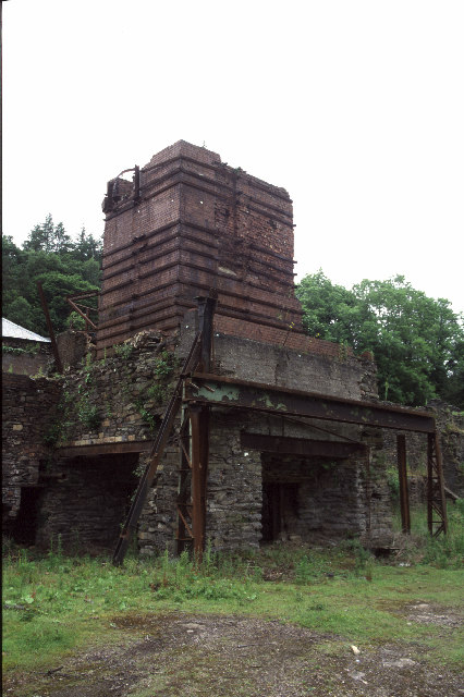
Backbarrow Ironworks
- Established in 1711. Isaac Wilkinson worked here, he developed a furnace fuelled by charcoal and was one of the first of its kind in the UK.The main products of the …
Co-Curate Page
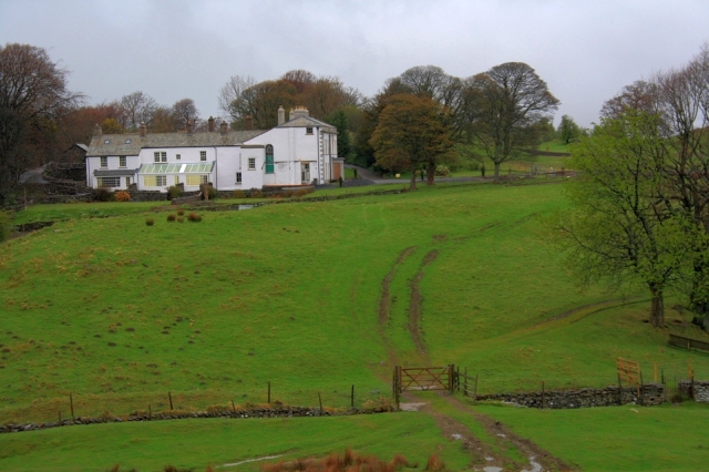
Bigland Hall
- Overview Map Street View Bigland Hall is a large county house, located about a mile south of Backbarrow and a similar distance south-east of Haverthwaite in Cumbria. The Hall was …

Co-Curate Page
Church of St Anne, Haverthwaite
- Overview Map Street View St Anne's Church is located on Old Barrow Road in Haverthwaite. It was originally built in 1825 as a chapel of ease to Holy Trinity Church in …
Co-Curate Page
Low Wood Gunpowder Works
- Overview About Low Wood Gunpowder Works Map Street View The Low Wood Gunpowder Works, located on the east banks of the River Leven at Low Wood, were in operation from …
Co-Curate Page
War Memorial, Haverthwaite
- Overview Map Street View The war memorial for Haverthwaite is located at the edge of the village cemetery, overlooking Levis Garth (road). The memorial commemorates 15 local servicemen who lost …
Co-Curate Page
Backbarrow Bridge
- Overview Map Street View The bridge at Backbarrow carries the road over white water falls on the River Leven. The bridge dates from the late 17th or 18th century and …
Co-Curate Page
Low Wood Bridge, over River Leven
- Overview Map Street View Low Wood Bridge carries the B5278 road over the River Leven between Low Wood and Haverthwaite in Cumbria. The bridge is located at the upper tidal limit of …
Co-Curate Page
Backbarrow Ironworks
- Established in 1711. Isaac Wilkinson worked here, he developed a furnace fuelled by charcoal and was one of the first of its kind in the UK.The main products of the …


