Topics > Civil Parishes in Cumbria > Stainton Civil Parish > Historic Buildings and Monuments in Stainton Civil Parish, Cumbria
Historic Buildings and Monuments in Stainton Civil Parish, Cumbria
Listed buildings and scheduled monuments in Stainton Civil Parish, Cumbria, from the National Heritage List for England[1]. In the absence of a published 'local list', some other public buildings of interest may also be included. Use the Search (below) if looking for a specific building / monument.
| Structure | List No. | Grade | Built~ | Note |
|---|---|---|---|---|
| Milestone Approximately 150 Yards North-West of Storth End Farmhouse Near Half Penny Turn off | 1137419 | II | 1826 | Halfpenny |
| Pack Horse Bridge over Stainton Beck | 1086531 | II | C17th | Stainton |
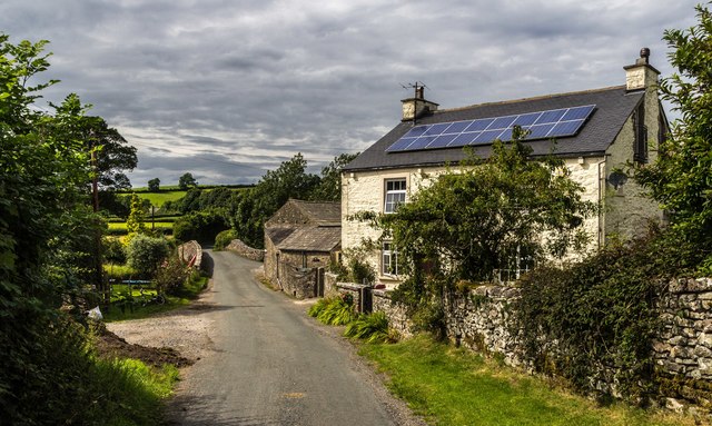
| Sellet Hall | 1137413 | II | C16th | Farmhouse |
| Stainton Aqueduct Carrying Kendal/ Lancaster Canal over Stainton Beck and Public Footpath NGR52268542 | 1086532 | II | 1818 | Stainton |
| Stainton Bridge End, Bridge over Lancaster to Kendal Canal, NGR52428526 | 1086533 | II | c.1818 | Canal bridge |
| Stainton Bridge over Stainton Beck Immediately South West of Stainton Bridge End Farm NGR52288523 | 1086534 | II | C17th | Road Bridge |
| Stainton Crossing Bridge over Kendal/Lancaster Canal NGR52058543 | 1137441 | II | c.1818 | |
| Tethering Post on Towpath to Kendal Lancaster Canal Approximately 100 Yards East of Stainton Aqueduc | 1312328 | II | C19th | |
| United Reformed Church | 1137429 | II | c.1698 | Now The Stainton Institute |
| Packhorse bridge at the Post Office | 1007138 | n/a | C17th | Scheduled Monument |
| Castlesteads small multivallate hillfort on The Helm | 1008263 | n/a | Iron Age | Scheduled Monument. Partly in this parish. |
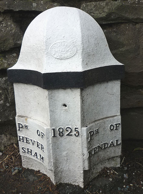
| Boundary Post Approximately 200 Yards North of Punch Bowl Public House | 1086581 | II | 1825 | Barrows Green. Old parish boundry. |
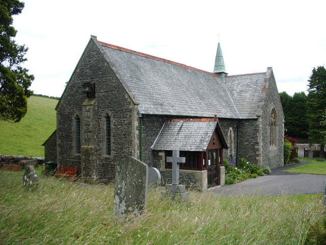
| Church of St Thomas | not listed | n/a | 1875 | Crosscrake |
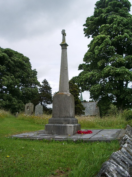
| Crosscrake War Memorial | not listed | n/a | c.1920s | Crosscrake |
Primary source: the National Heritage List for England - NHLE is the register of nationally protected historic buildings and sites in England, including listed buildings, scheduled monuments, protected wrecks, registered parks and gardens, and battlefields. The list is maintained by Historic England. Check NHLE for updates and new entries. Secondary sources: British Listed Buildings.
Co-Curate Page
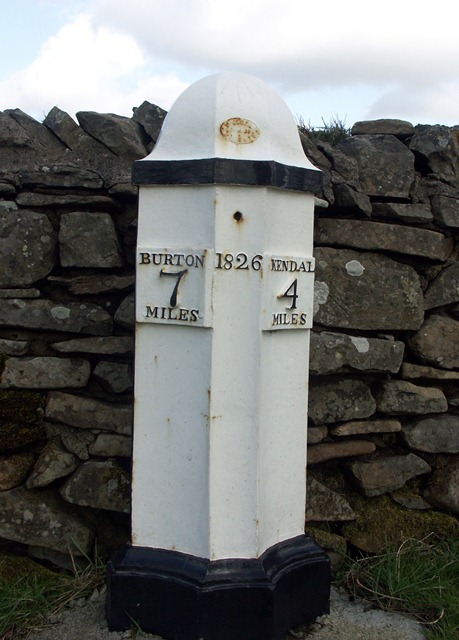
Old Milepost, A65, Halfpenny
- Overview Map Street View This old milepost is located by the side of the A65 road near the turn off for Halfpenny. The cast iron milpost is dated 1826 and …
Co-Curate Page
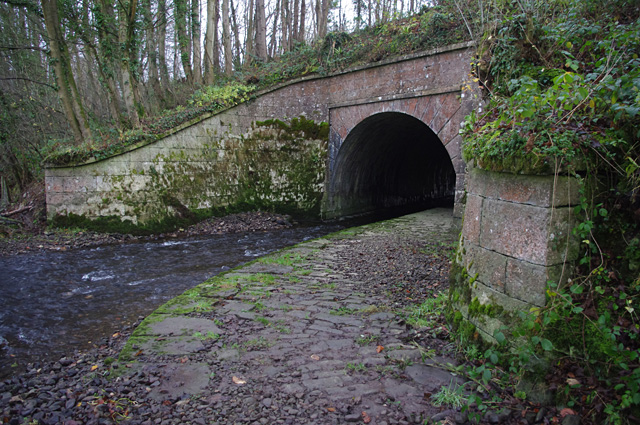
Stainton Aqueduct
- Overview Map Stainton Aqueduct was built in c.1818 by John Fletcher (engineer) to carry the Kendal - Lancaster Canal over Stainton Beck and footpath. The Aqueduct, located to the south of …
Co-Curate Page
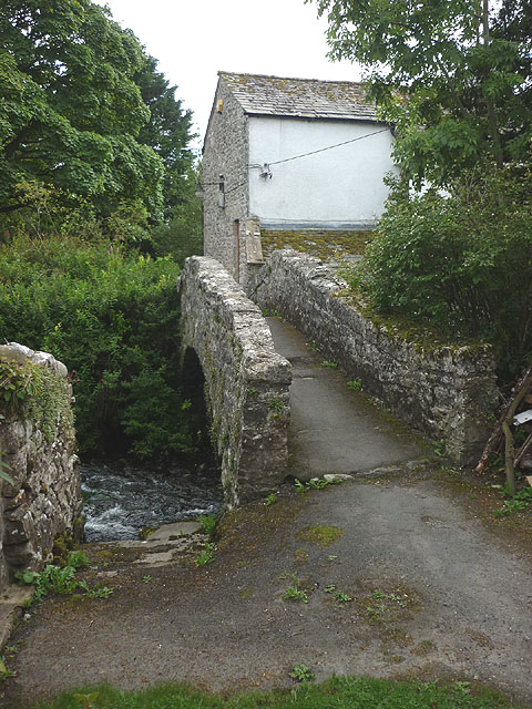
Pack Horse Bridge, Stainton
- Overview Map Street View The pack horse bridge over Stainton Beck in Stainton village is thought to date from the 17th century. It is a single segmented arch bridge made …
Co-Curate Page
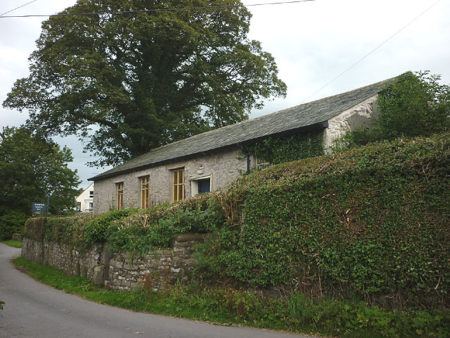
The Stainton Institute
- Overview Map Street View The Stainton Institute, on Stainton Lane in Stainton village, is a former chapel which is now used as a community building. It was originally built in …
Co-Curate Page
Bridge at Stainton Stainton End
- Overview Map Street View Road Bridge over Stainton Beck at Stainton Bridge End, to the south of Stainton village. The bridge is probably 17th or early 18th century. It is …
Co-Curate Page
Old Boundary Post, Barrows Green
- Overview Map Street View This old boundary post is located by the A65 road on a garden wall of a house located about 200 yrds north of the Punch Bowl …
Co-Curate Page
Church of St Thomas, Crosscrake
- Overview Map Street View St. Thomas' Church is located on Shyreakes Lane in Crosscrake. The church was rebuilt 1874 - 1875, designed by the Lancaster architects Paley & Austin, who had a …
Co-Curate Page
War Memorial, Crosscrake
- Overview Map Street View Crosscrake War Memorial is located in the churchyard of St Thomas' Church in Crosscrake, and visible from Shyreakes Lane. The memorial is a Latin cross mounted …

Co-Curate Page
Old Milepost, A65, Halfpenny
- Overview Map Street View This old milepost is located by the side of the A65 road near the turn off for Halfpenny. The cast iron milpost is dated 1826 and …
Co-Curate Page
Stainton Aqueduct
- Overview Map Stainton Aqueduct was built in c.1818 by John Fletcher (engineer) to carry the Kendal - Lancaster Canal over Stainton Beck and footpath. The Aqueduct, located to the south of …
Co-Curate Page
Pack Horse Bridge, Stainton
- Overview Map Street View The pack horse bridge over Stainton Beck in Stainton village is thought to date from the 17th century. It is a single segmented arch bridge made …
Co-Curate Page
The Stainton Institute
- Overview Map Street View The Stainton Institute, on Stainton Lane in Stainton village, is a former chapel which is now used as a community building. It was originally built in …
Co-Curate Page
Bridge at Stainton Stainton End
- Overview Map Street View Road Bridge over Stainton Beck at Stainton Bridge End, to the south of Stainton village. The bridge is probably 17th or early 18th century. It is …
Co-Curate Page
Old Boundary Post, Barrows Green
- Overview Map Street View This old boundary post is located by the A65 road on a garden wall of a house located about 200 yrds north of the Punch Bowl …
Co-Curate Page
Church of St Thomas, Crosscrake
- Overview Map Street View St. Thomas' Church is located on Shyreakes Lane in Crosscrake. The church was rebuilt 1874 - 1875, designed by the Lancaster architects Paley & Austin, who had a …


