Topics > Northumberland > Civil Parishes in Northumberland > Shotley Low Quarter Civil Parish > Historic Buildings and Monuments in Shotley Low Quarter
Historic Buildings and Monuments in Shotley Low Quarter
Listed buildings and scheduled monuments in Shotley Low Quarter Civil Parish, Northumberland, from the National Heritage List for England[1]. In the absence of a published 'local list', some other public buildings of interest may also be included. Use the Search (below) if looking for a specific building / monument.
| Structure | List No. | Grade | Built~ | Note |
|---|---|---|---|---|
| 3 Stone Water Troughs at Unthank | 1045289 | II | ||
| Allensford Blast Furnace, on N. Bank of R. Derwent 250 Metres East of Bridge | 1045303 | II | C17th | Allensford |
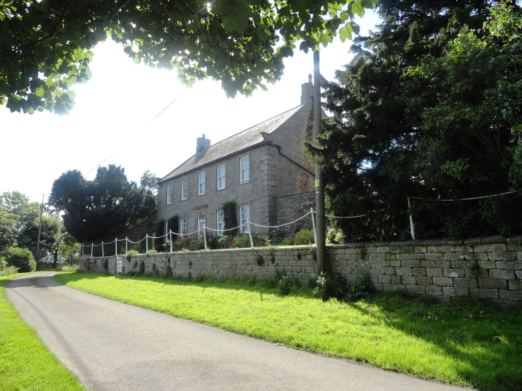
| Allensford Mill Farmhouse and Adjacent Outbuildings | 1045297 | II | C17th | Allensford |
| Black Hedley Farmhouse | 1156166 | II | c.1750 | Black Hedley |
| Boundary Stone Alongside Fence at NGR NZ04924972 | 1240686 | II | ||
| Boundary Stone at Above NGR NZ04944950 | 1240690 | II | ||
| Boundary Stone at NFR NZ05224956 | 1240691 | II | ||
| Boundary Stone at NGR NZ05404894 | 1260896 | II | ||
| Boundary Stone at NGR NZ04844956 | 1240688 | II | ||
| Boundary Stone at NGR NZ04914951 | 1240689 | II | ||
| Boundary Stone at NGR NZ05244958 | 1240692 | II | ||
| Boundary Stone at NGR NZ05304936 | 1240695 | II | ||
| Boundary Stone at NGR NZ05364945 | 1240694 | II | ||
| Boundary Stone at NGR NZ05364947 | 1240720 | II | ||
| Boundary Stone at NGR NZ05384913 | 1260916 | II | ||
| Boundary Stone at NGR NZ06634990 | 1045314 | II | ||
| Boundary Stone at NGR NZ06645006 | 1156465 | II | ||
| Boundary Stone at NGR NZ05234930 | 1240722 | II | ||
| Burn House, and Burn House Cottage | 1156096 | II | ||
| Chatt Headstone 6 Metres East of Church of St Andrew | 1045308 | II | ||
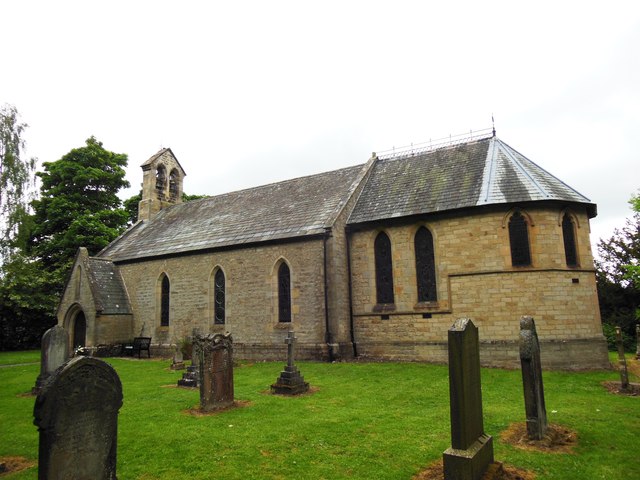
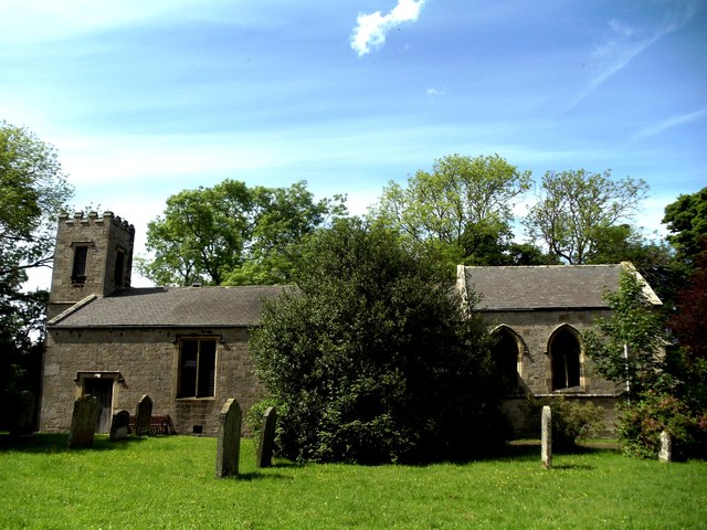
| Church of St Andrew | 1156312 | II | 1769 | Graymare Hill |
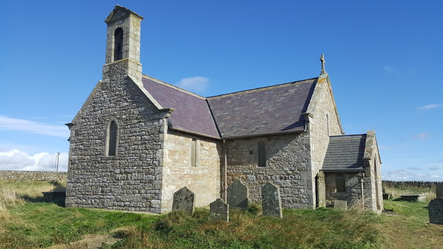
| Church of St John | 1303009 | II | 1836 | Snods Edge |
| Crooked Oak Farmhouse | 1370295 | II | ||
| Derwent Bridge | 1045302 | II | 1829 | near Derwent Reservoir |
| Doctor's Cottage, 40 Metres North of Black Hedley Farmhouse | 1156239 | II | Black Hedley | |
| Durhamfield Farmhouse and Adjacent Outbuildings | 1045296 | II | ||
| Ebchester Bridge | 1260965 | II | 1862 | Partly in this parish |
| Farmbuilding Range South-West of Greenhead Cottages | 1156292 | II | ||
| Farmbuildings North and East of High Waskerley Farmhouse | 1370296 | II | ||
| Farmbuildings to West of Whittonstall Hall Farmhouse | 1370293 | II | C19th | Whittonstall |
| Field Head Farmhouse | 1370292 | II | ||
| Forge Cottage | 1045274 | II | ||
| Garden Ornament 6 Metres East of South-East Corner of Shotley Hall | 1045300 | II | Shotley Hall | |
| Garden Walls to East, North and South of Black Hedley Farmhouse | 1045304 | II | Black Hedley | |
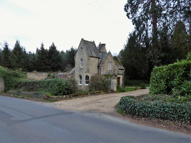
| Gate Lodge to Shotley Hall | 1370291 | II | 1863 | |
| Gate Piers to Shotley Hall, with Attached Forecourt Walls | 1303057 | II | c.1856 | Shotley Hall |
| Gibson Headstone 13 Metres South-East of Church of St. Andrew | 1302894 | II | ||
| Granary Cottage and Adjacent Farmbuilding Range to North of Black Hedley Farmhouse | 1045305 | II | Black Hedley | |
| Greenhead Cottages and Attached Walls | 1045306 | II | ||
| Greenhead House | 1045307 | II | ||
| Hearse House North-West of Church of St. Andrew | 1045309 | II | Graymare Hill | |
| High Waskerley Farmhouse | 1302850 | II | ||
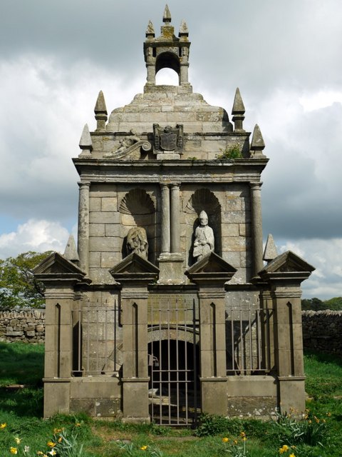
| Hopper Mausoleum North-East of Church of St. Andrew | 1302881 | I | c.1752 | Graymare Hill |
| Hunter Headstone 3 Metres South-East of Chancel of Church of St. Andrew | 1045310 | II | ||
| Limekiln 30 Metres North of Lead Mill House | 1156462 | II | ||
| Milestone 110 Metres North of Entrance to Eddisbridge Farm | 1156119 | II | ||
| Moor Game Byre 600 Metres West of New House Farm | 1370289 | II | ||
| Old Wash-House 10 Metres North-West of Black Hedley Farmhouse | 1370294 | II | Black Hedley | |
| Orchard House | 1045299 | II | ||
| Outbuilding 20 Metres East of No. 2 Newlands Farm Cottages | 1156493 | II | C19th | Newlands. Former Methodist Chapel |
| Post Office Adjacent House | 1045298 | II | ||
| Boundary stone about 500m. north- east of Shotley Spa | 1067544 | II | C19th | |
| Shotley Bridge, over River Derwent | 1240558 | II | C18th | Partly in this parish |
| Shotley Hall | 1156072 | II* | 1863 | |
| Shotley Hall Stable Block and Attached Wall to South-West | 1045301 | II | c.1863 | Shotley Hall |
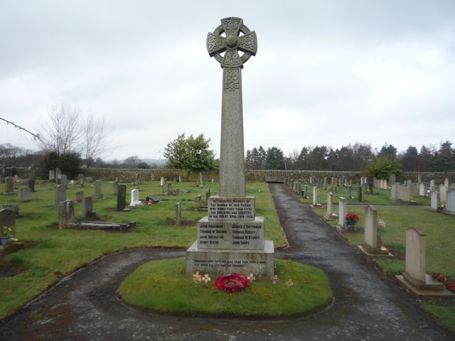
| Shotley Low Quarter War Memorial | 1439785 | II | 1922 | Snods Edge, St John's Churchyard |
| Smith Headstone 2 Metres South-West of Porch of Church of St. Andrew | 1045311 | II | ||
| Socket Stone 2.5 Metres South-West of Porch of St. Andrew | 1156423 | II | ||
| The Old School | 1156505 | II | c.1840 | Snods Edge |
| The Old Schoolhouse | 1045275 | II | 1803 | Snods Edge |
| The Old Stable and Attached Garden Wall 30 Metres South West of Black Hedlay Farmhouse | 1156195 | II | Black Hedley | |
| Thompson Headstone 6 Metres West of Church of St. Andrews | 1045312 | II | ||
| Whittonstall Old Vicarage | 1156525 | II | 1830 | Whittonstall |
| Allensford blast furnace | 1006405 | n/a | C17th | Scheduled Monument |
| Hammer Mill | not listed | n/a | ?C19th | Shotleyfield. Ancient forge? |
| The Snods Community Hall | not listed | n/a | 1877 | Snods Edge |
| Church of St Philip and St James | not listed | n/a | c.1830 | Whittonstall |
Primary source: the National Heritage List for England - NHLE is the register of nationally protected historic buildings and sites in England, including listed buildings, scheduled monuments, protected wrecks, registered parks and gardens, and battlefields. The list is maintained by Historic England. Check NHLE for updates and new entries. Secondary sources: British Listed Buildings and Keys to the Past.
Co-Curate Page
Hopper Mausoleum, Shotley Low Quarter
- The Hopper Mausoleum in the churchyard of St. Andrew's Church, Greymare Hill in Northumberland. It is inscribed: "Erected by Humfrey Hopper of Black Hedley, in memory of his wife Jane …
Co-Curate Page
Shotley Low Quarter War Memorial
- Overview Map Street View The parish war memorial for Shotley Low Quarter is located in the churchyard of St John's Church at Snods Edge. The memorial can be seen from …
Co-Curate Page
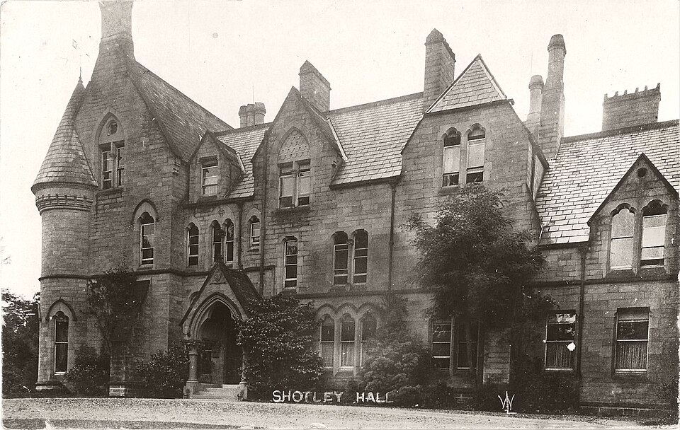
Shotley Hall
- Overview Map Shotley Hall is located about ¼ mile west of Shotley Bridge. The Hall is in Northumberland, close to the border with County Durham. The house was built in …
Co-Curate Page
Shotley Bridge (bridge)
- Overview Map Street View The stone bridge over the River Derwent at Shotley Bridge was built in the late 18th century, later widened in c1820. The bridge is Grade II …
Co-Curate Page
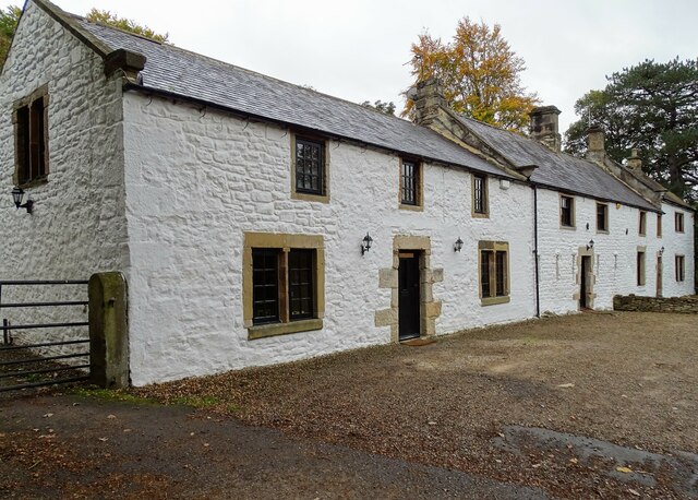
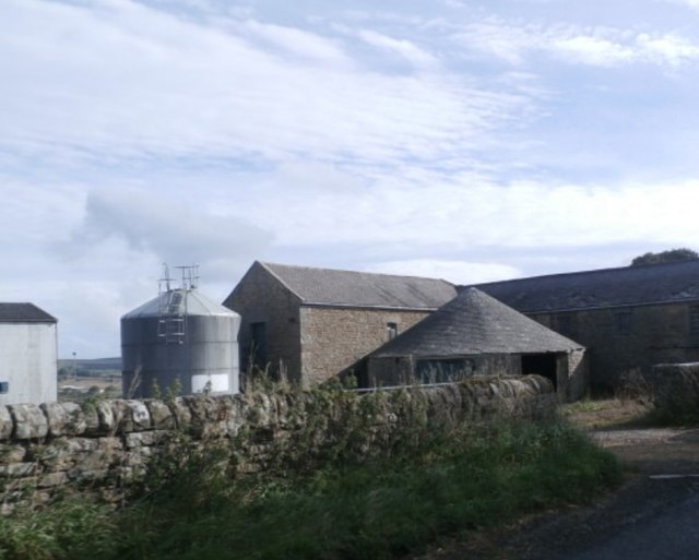
Allensford Mill Farmhouse
- Overview Map Street View The earlier part of the house is possibly a bastle remodelled in the late 17th or early 18th century. At a later date it became the …
Co-Curate Page
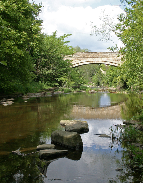
Derwent Bridge near Derwent Reservoir
- Overview Map Street View Derwent Bridge (aka Ratchwoodford Bridge) carries the B6278 road over the River Derwent (Tyne) in Northumberland. It is located near the dam at the south end …
Co-Curate Page
Wittonstall Hall Farm
- Overview Map Street View Wittonstall Hall Farm is located off the B6309 road, south of the village of Wittonstall. There are early 19th century planned farmbuildings, with ranges on the …
Co-Curate Page
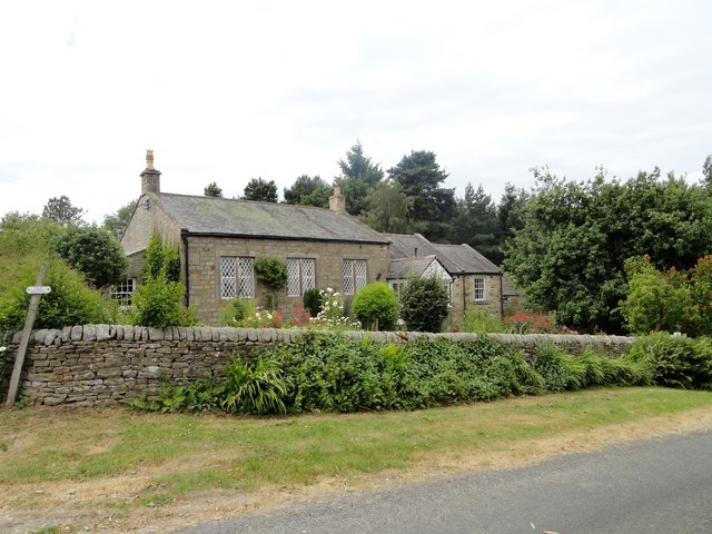
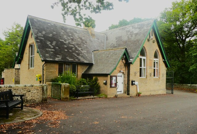
The Old School, Snods Edge
- Overview Map Street View This former school at Snods Edge, dates from c.1840. It is now a prvate dwelling. The old school building is Grade II listed on the National …
Co-Curate Page
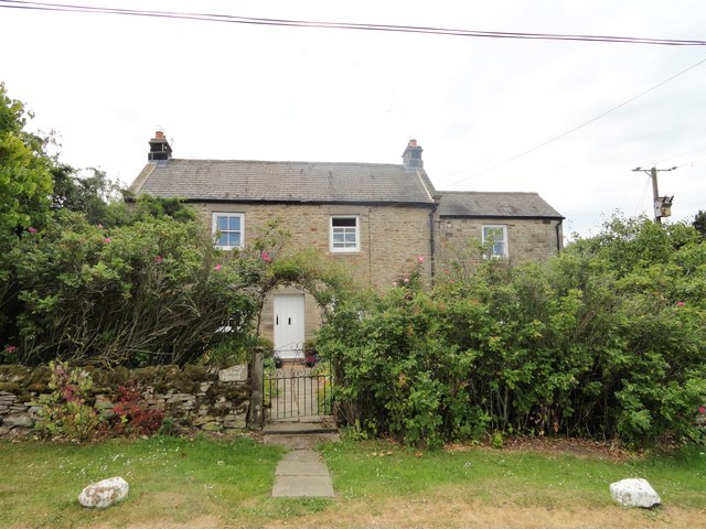
The Old School House, Snods Edge
- Overview Map Street View This house at Snods Edge was built in 1803 (dated slab re-set on north). It was previously the Schoolmaster's house, with the Old School located next …
Co-Curate Page
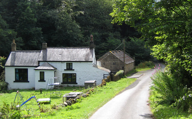
Hammer Mill, near Shotleyfield
- Overview Map Street View Hammer Mill is located south-east of Shotleyfield, on Hammermill Lane, by Shotleyfield Burn. The building currently here appears to be 19th Century (though possibly older) and …
Co-Curate Page
The Snods Community Hall
- Overview Map Street View The Snods Community Hall (previously know as St Johns Church Hall) is located on Burnmill Bank (B6278) at Snods Edge. The building dates from 1877, when …
Co-Curate Page
Church of St. Philip and St. James, Whittonstall
- Overview Map Street View St. Philip and St. James' Church in Whittonstall was built in c.1830, designed by Jonathan Marshall.[1] It replaced a chapel of ease on the same site, …
Co-Curate Page
Farmhouse, Black Hedley
- The farmhouse at Black Hedley was built in c.1750 as a house for Humphrey Hopper. The rear wing of the buildng was rebuilt in c.1930 after a fire. The house …

Co-Curate Page
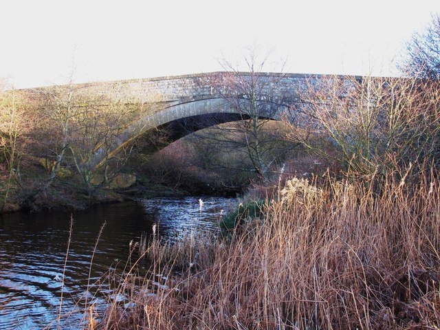
Old bridge at Ebchester
- Overview Map Street View The stone bridge over the River Derwent at Ebchester was built in 1862. The stone bridge, with 3 arches, straddles the county border between County Durham …

Co-Curate Page
Allensford blast furnace
- Scheduled Monument area - based on Historic England data (Open Government Licence). The remains of a late 17th or early 18th century blast furnace are located in the woods by …

Co-Curate Page
Hopper Mausoleum, Shotley Low Quarter
- The Hopper Mausoleum in the churchyard of St. Andrew's Church, Greymare Hill in Northumberland. It is inscribed: "Erected by Humfrey Hopper of Black Hedley, in memory of his wife Jane …
Co-Curate Page
Shotley Low Quarter War Memorial
- Overview Map Street View The parish war memorial for Shotley Low Quarter is located in the churchyard of St John's Church at Snods Edge. The memorial can be seen from …
Co-Curate Page
Shotley Hall
- Overview Map Shotley Hall is located about ¼ mile west of Shotley Bridge. The Hall is in Northumberland, close to the border with County Durham. The house was built in …
Co-Curate Page
Shotley Bridge (bridge)
- Overview Map Street View The stone bridge over the River Derwent at Shotley Bridge was built in the late 18th century, later widened in c1820. The bridge is Grade II …
Co-Curate Page
Allensford Mill Farmhouse
- Overview Map Street View The earlier part of the house is possibly a bastle remodelled in the late 17th or early 18th century. At a later date it became the …
Co-Curate Page
Derwent Bridge near Derwent Reservoir
- Overview Map Street View Derwent Bridge (aka Ratchwoodford Bridge) carries the B6278 road over the River Derwent (Tyne) in Northumberland. It is located near the dam at the south end …
Co-Curate Page
Wittonstall Hall Farm
- Overview Map Street View Wittonstall Hall Farm is located off the B6309 road, south of the village of Wittonstall. There are early 19th century planned farmbuildings, with ranges on the …
Co-Curate Page
The Old School, Snods Edge
- Overview Map Street View This former school at Snods Edge, dates from c.1840. It is now a prvate dwelling. The old school building is Grade II listed on the National …
Co-Curate Page
The Old School House, Snods Edge
- Overview Map Street View This house at Snods Edge was built in 1803 (dated slab re-set on north). It was previously the Schoolmaster's house, with the Old School located next …
Co-Curate Page
Hammer Mill, near Shotleyfield
- Overview Map Street View Hammer Mill is located south-east of Shotleyfield, on Hammermill Lane, by Shotleyfield Burn. The building currently here appears to be 19th Century (though possibly older) and …
Co-Curate Page
The Snods Community Hall
- Overview Map Street View The Snods Community Hall (previously know as St Johns Church Hall) is located on Burnmill Bank (B6278) at Snods Edge. The building dates from 1877, when …
Co-Curate Page
Church of St. Philip and St. James, Whittonstall
- Overview Map Street View St. Philip and St. James' Church in Whittonstall was built in c.1830, designed by Jonathan Marshall.[1] It replaced a chapel of ease on the same site, …
Co-Curate Page
Farmhouse, Black Hedley
- The farmhouse at Black Hedley was built in c.1750 as a house for Humphrey Hopper. The rear wing of the buildng was rebuilt in c.1930 after a fire. The house …
Co-Curate Page
Old bridge at Ebchester
- Overview Map Street View The stone bridge over the River Derwent at Ebchester was built in 1862. The stone bridge, with 3 arches, straddles the county border between County Durham …


