Topics > Northumberland > Civil Parishes in Northumberland > Rochester with Byrness Civil Parish > Historic Buildings and Monuments in Rochester & Byrness
Historic Buildings and Monuments in Rochester & Byrness
Listed buildings and scheduled monuments in Rochester with Byrness Civil Parish, Northumberland, from the National Heritage List for England[1]. In the absence of a published 'local list', some other public buildings of interest may also be included. Use the Search (below) if looking for a specific building / monument. Skip to photos.
| Structure | List No. | Grade | Built~ | Notes |
|---|---|---|---|---|
| Birdhopecraig United Reformed Church | 1156356 | II | 1826 | Rochester. Now a holiday cottage. |
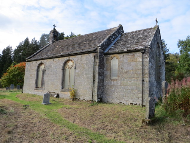
| Church of St Francis of Assisi | 1044835 | II | 1796 | Byrness |
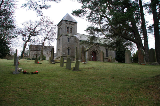
| Church of the Holy Trinity | 1044875 | II | 1844 | Horsley |
| Compensation Arch and Basin at Catcleugh Reservoir | 1156386 | II | 1899 | Catcleugh |
| Dam, Overflow Bridge and Valve House at Catcleugh Reservoir | 1044836 | II | 1904 | Catcleugh |
| Garden Wall to South of Stobbs | 1302903 | II | C18th | Stobbs |
| Hedley and Robson Tombs Circa 20 Yards South-East of Church of St Francis | 1156381 | II | 1723 | Byrness |
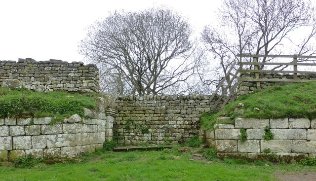
| High Rochester Roman Fort | 1044837 | II | C3rd | Bremenium |
| Milestone at Byrness | 1044872 | II | C19th | A68, Byrness |
| Milestone by Bennetsfield Farm | 1302902 | II | C19th | A68, Bennettsfield |
| Milestone Circa 1/4 Mile North-East of Blakehopeburnhaugh | 1044873 | II | C19th | A68, Blakehopeburnhaugh |
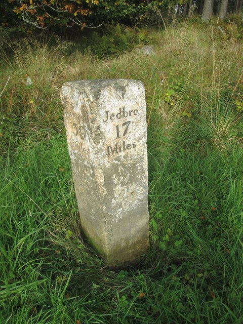
| Milestone Circa 1/4 Mile West of Whitelee | 1156345 | II | C19th | A68, Whitelee |
| Milestone Circa 100 Yards North-West of Low Byrness | 1302889 | II | C19th | A68, Low Byrness |
| Milestone Circa 100 Yards South-East of Ramshope Lodge | 1044871 | II | ||
| Milestone Circa 40 Yards South-East of Catcleugh House | 1156407 | II | C19th | Catcleugh |
| Milestone Circa 40 Yards South-East of Ramshope Cottage | 1156348 | II | ||
| Milestone North West of Bellshiel Bridge at NGR 802997 | 1052206 | II | ||
| Milestone South of Birdhopecraig United Reformed Church at NGR 820980 | 1052207 | II | C19th | A68, Rochester |
| Milestone South West of Church of the Holy Trinity at NGR 842971 | 1052208 | II | C19th | A68, Horsley |
| Nether Houses | 1156415 | II | ||
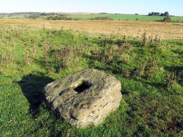
| Outer Golden Pot | 1041301 | II | C14th | Dere Street |
| Rochester Old School House | 1044874 | II | C19th | Portch 1852 |
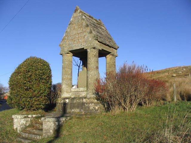
| Rochester War Memorial | 1302895 | II | 1921 | Off A68 |
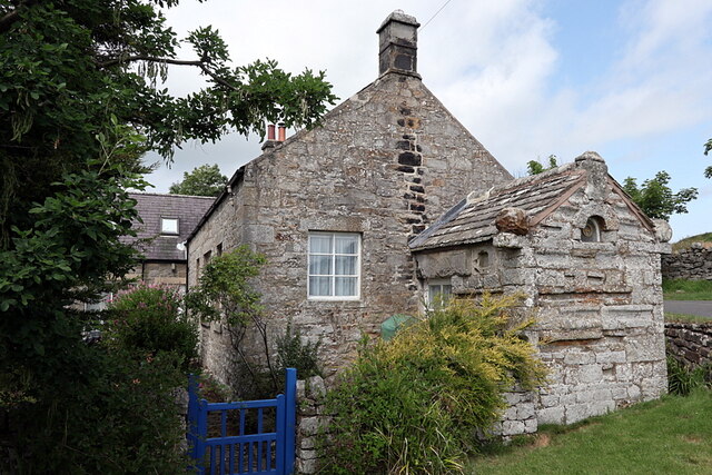
| Rose Cottage | 1044838 | II | C16th | High Rochester |
| Shelter Shed and Granary Circa 40 Yards North-West of the Redesdale Arms | 1044833 | II | ||
| Stables and Byre Circa 30 Yards North-West of the Redesdale Arms | 1370539 | II | ||
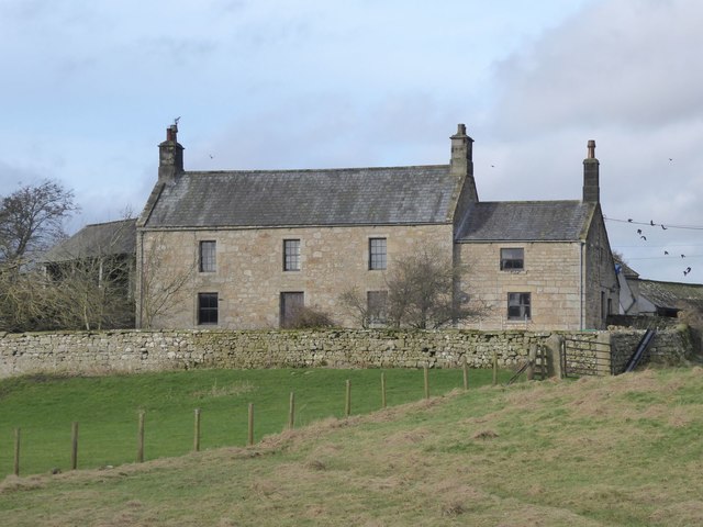
| Stobbs | 1044834 | II | C17th | Farmhouse |
| The Bastle | 1302885 | II | C16th | High Rochester |
| The Rectory | 1370500 | II | ||
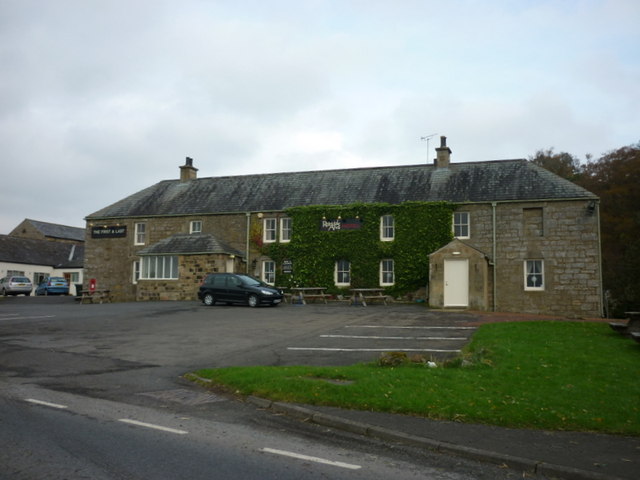
| The Redesdale Arms | 1156371 | II | C16th | Horsley. Bastle, extended in C18th. |
| Wood Cabin Circa 100 Yards South-East of Catcleugh House | 1370501 | II | C19th | Catcleugh. Black House |
| Petty Knowes Roman Cemetery and Length of Dere Street Roman Road, Rochester | 1009924 | n/a | Scheduled Monument | |
| Bremenium Roman station, High Rochester | 1006610 | n/a | C3rd | Scheduled Monument |
| Bagraw Roman camp and section of Roman road, 463m NNW of Bagraw | 1006506 | n/a | Scheduled Monument | |
| Romano-British enclosed settlement 400m south east of Woolaw | 1009374 | n/a | Scheduled Monument | |
| Romano-British farmstead 330m west of Rattenraw Farm | 1008994 | n/a | Scheduled Monument | |
| Romano-British farmstead 350m south of Rattenraw Farm | 1009372 | n/a | Scheduled Monument | |
| Romano-British farmstead 570m west of Woolaw | 1009373 | n/a | Scheduled Monument | |
| Romano-British enclosed settlement and medieval settlement 300m south of Burdhope | 1011904 | n/a | Scheduled Monument | |
| Branshaw deserted settlement, bastle, field system and section of Roman road | 1015840 | n/a | Scheduled Monument | |
| Long cairn 360m south west of Dour Hill | 1009379 | n/a | Scheduled Monument | |
| Roman camp, 250m north-west of Silloans | 1011391 | n/a | Scheduled Monument | |
| Roman camp and prehistoric round cairn 700m north-east of Bellshiel Bridge | 1011414 | n/a | Scheduled Monument | |
| Bellshiel Law long cairn | 1009459 | n/a | Scheduled Monument | |
| Blakehope Roman fort and Roman temporary camp | 1006507 | n/a | Scheduled Monument | |
| Romano-British settlement, field system and cord rig cultivation 390m north east of Yatesfield Hill | 1015532 | n/a | Scheduled Monument | |
| Farm blast shelter at Featherwood | 1021035 | n/a | Scheduled Monument | |
| Two Romano-British settlements, two stone hut circles, field system and associated cord rig cultivation, 650m west of Nether Houses | 1015529 | n/a | Scheduled Monument | |
| Evistones medieval settlement, field system and three bastles | 1016815 | n/a | Scheduled Monument | |
| Blockhouse immediately west of Featherwood | 1021034 | n/a | Scheduled Monument | |
| The Three Kings four poster stone circle and round cairn | 1015525 | n/a | Scheduled Monument | |
| World War I practice trenches 740m north west of Short Fell | 1021025 | n/a | Scheduled Monument | |
| Observation post 240m west of Ridlees Cairn | 1021027 | n/a | Scheduled Monument | |
| Observation post 820m SSE of Hanging Crag | 1021026 | n/a | Scheduled Monument | |
| Two Roman camps, 550m east of Burdhopecrag Hall | 1011392 | n/a | Scheduled Monument | |
| Roman camp, 400m SSW of Sills Farm | 1011393 | n/a | Scheduled Monument | |
| Cairn group 330m south-east of Bellshiel Law | 1011404 | n/a | Scheduled Monument | |
| Round cairn, 800m east of Mally's Crag | 1014077 | n/a | Scheduled Monument | |
| Round cairn, 240m east of Ravens Pike | 1014078 | n/a | Scheduled Monument | |
| Round cairn on western slopes of Dour Hill, 250m south west of summit | 1015844 | n/a | Scheduled Monument | |
| Middle Golden Pot medieval wayside cross | 1008284 | n/a | C14th | Scheduled Monument. Dere Street |
| Unenclosed hut circle settlement 250m west of Woolaw | 1009375 | n/a | Scheduled Monument | |
| Roman temporary camp at Dargues | 1009376 | n/a | Scheduled Monument | |
| Medieval wayside cross, 200m NNW of Brownrigg | 1017596 | n/a | Medieval | Scheduled Monument. Dere Street |
| Roman Camp, 750m SSW of Sills Farm | 1017597 | n/a | Scheduled Monument | |
| Round cairn on Ravens Pike | 1018938 | n/a | Scheduled Monument | |
| Round cairn 230m west of Ridlees Cairn | 1021030 | n/a | Scheduled Monument | |
| Roman fort, two Roman fortlets, two Roman camps, a section of Roman road and a medieval settlement and chapel at Chew Green | 1015847 | n/a | Scheduled Monument | |
| Outer Golden Pot medieval wayside cross | 1008282 | n/a | C14th | Scheduled Monument |
| Ridlees round cairn, 640m north east of Hanging Crag | 1008433 | n/a | Scheduled Monument | |
| Roman camp, 1.05km north of Featherwood | 1008882 | n/a | Scheduled Monument | |
| Watty Bell's round cairn | 1015839 | n/a | Scheduled Monument | |
| Gauge House, Catcleugh Reservoir | not listed | n/a | 1903 | Catcleugh |
| Remains of Railway Bridge | not listed | n/a | 1895 | Catcleugh |
| Overflow Spillway, Catcleugh Reservoir | not listed | n/a | C19th | Catcleugh |
| Iron Age Settlement, noth of Rattenraw | not listed | n/a | Iron Age | Rattenraw |
| Rattenraw Bastle, ruins | not listed | n/a | Rattenraw |
Primary source: the National Heritage List for England - NHLE is the register of nationally protected historic buildings and sites in England, including listed buildings, scheduled monuments, protected wrecks, registered parks and gardens, and battlefields. The list is maintained by Historic England. Check NHLE for updates and new entries. Secondary sources: British Listed Buildings and Keys to the Past.
Co-Curate Page
Church of the Holy Trinity, Horsley
- Overview Map Street View Holy Trinity Church in Horsley, is located off the A68 road, just over ½ mile south-east of the village of Rochester in Northumberland. The church was …
Co-Curate Page
Redesdale Arms
- Overview Map Street View The Redesdale Arms is a hotel and restaurant located on the A68 road at Horsley, about 3½ miles north-west of Otterburn and 1 mile south-east of …
Co-Curate Page
Bremenium Roman Fort
- Overview About Bremenium Map Street View Bremenium was an ancient Roman fort (castra) located at Rochester, Northumberland, England. The fort was one of the defensive structures built along Dere …
Co-Curate Page
Old School House, Rochester
- Overview Map Street View The Old School House is located by the junction of the A68 and Roxby Gardens in Rochester, Northumberland. The porch was added in 1852, and was …
Co-Curate Page
War Memorial, Rochester
- Overview Map Street View The war memorial in Rochester, Northumberland, was unveiled on the 3rd of December 1921 by Major Clifton Brown, M.P. for Hexham. The memorial is inscribed with …
Co-Curate Page
Former Birdhopecraig Church, Rochester
- Overview Map Street View The former Birdhopecraig Church, now converted into a holiday home, is located at the northern edge of the village of Rochester in Northumberland. It was built …
Co-Curate Page
The Bastle, High Rochester
- Overview Map Street View The Bastle is a former bastlehouse located in High Rochester and situated within the defences of Bremenium Roman Fort. The Bastle dates from the 16th or …
Co-Curate Page
Rose Cottage bastle, High Rochester
- Overview Map Street View Rose Cottage is a former bastlehouse in High Rochester, and situated within the defences of Bremenium Roman Fort. It dates from the 16th or 17th century. …
Co-Curate Page
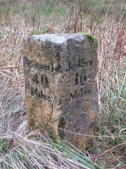
Old Milestone, A68, west of Whitelee
- There is an old Milestone by the A68, located about ¼mile west of Whitelee in Northumberland, close to the England-Scotland border. The milestone was erected by the Elsdon and Rudwater …

Co-Curate Page
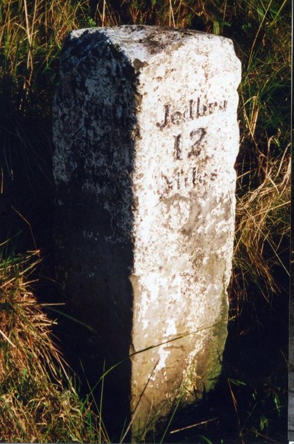
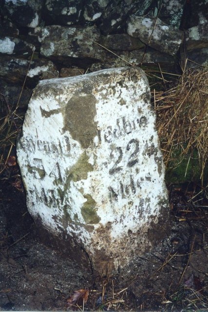
Old Milestone, Catcleugh
- There is an old Milestone in Catcleugh, to the east of Catcleugh Reservoir, in Northumberland. The milestone was erected by the Elsdon and Rudwater Turnpike Trust, probably in the 18th …

Co-Curate Page
Dam and Valve House, Catcleugh Reservoir
- The dam, overflow bridge and valve house of Catcleugh Reservoir were built 1891-1904 by T. and C. Hawksley, engineers, for the Newcastle and Gateshead Water Company. The valve house has …
Co-Curate Page
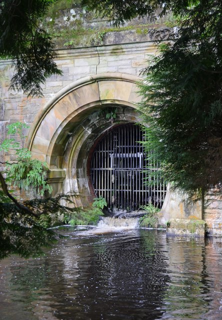
Compensation Arch, Catcleugh Reservoir
- Overview Map The compensation arch and basin carrying the River Rede at the base of the dam of Catcleugh Reseviour was built in 1899 by T. & C. Hawksley for …
Co-Curate Page
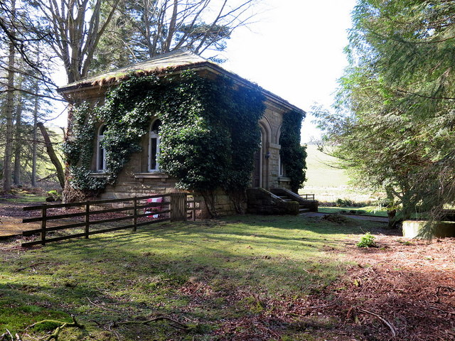
Gauge House, Catcleugh Reservoir
- Overview Map The Gauge House at Catcleugh Reservoir, located below the dam, was built in 1903 by the Newcastle and Gateshead Water Company, to regulate the water levels.

Co-Curate Page
Remains of Railway Bridge, Catcleugh
- There are the remains of a bridge over the River Rede a short distance east of Catcleugh Resevoir. These are the remnants of bridge bases for a 3' gauge railway …
Co-Curate Page
Overflow Spillway, Catcleugh Reservoir
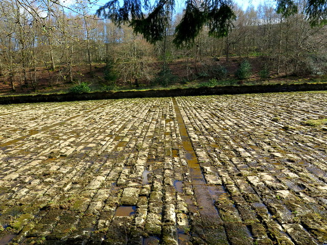
- Overview Map The overflow spillway at Catcleugh Reservoir (built 1884 to 1905) is located at the south end of the dam. It is a huge masonary constructed channel which feeds …
Co-Curate Page
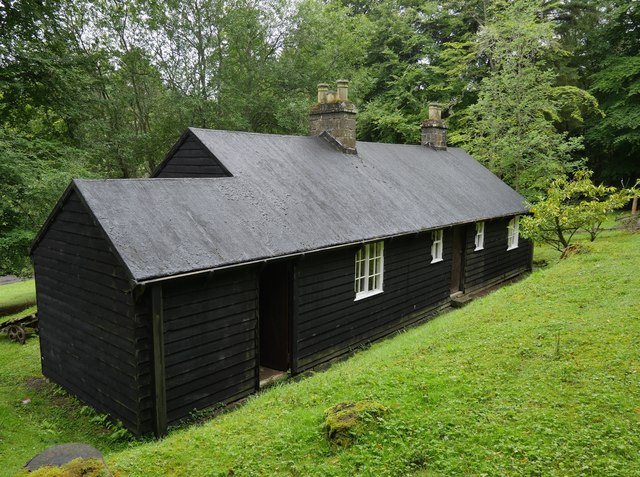
Black House, Catcleugh
- Overview Map The Black House at Catcleugh was built in c.1891 and is maintained as a heritage attraction in the Northumberland National Park. It is the last remaining wooden cabin …
Co-Curate Page
Old Milestone, A68, Horsley
- There is an old Milestone by the A68, located to the north of Horsley (Otterburn) in Northumberland, close to Church of the Holy Trinity. The milestone was erected by the …
Co-Curate Page
Old Milestone, A68, Byrness
- There is an old Milestone by the A68, located opposite Otterburn Green in Byrness in Northumberland. The milestone was erected by the Elsdon and Rudwater Turnpike Trust, probably in the …

Co-Curate Page
Old Milestone, A68, Blakehopeburnhaugh
- There is an old Milestone by the A68, located about ¼mile north-east of Blakehopeburnhaugh in Northumberland. The milestone was erected by the Elsdon and Rudwater Turnpike Trust, probably in the …
Co-Curate Page
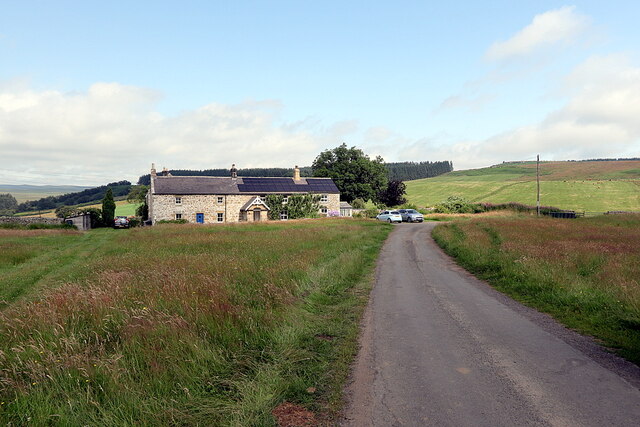
Stobbs (Byrness)
- Overview Map Stobbs is a farm located on the east banks of the River Rede, about ½mile south-east of the village of Rochester, in Northumberland. There is a minor road …
Co-Curate Page
Old Milestone, A68, Low Byrness
- There is an old Milestone by the A68, north-west of Low Byrness in Northumberland. The milestone was erected by the Elsdon and Rudwater Turnpike Trust, probably in the 18th or …

Co-Curate Page
Old Milestone, A68, Bennettsfield
- There is an old Milestone by the A68, located near Bennettsfield Farm in Northumberland. The milestone was erected by the Elsdon and Rudwater Turnpike Trust, probably in the 18th or …

Co-Curate Page
Outer Golden Pot
- Overview Map The Outer Golden Pot is the socket stone of a medieval wayside cross, situated in an elevated position on the western edge of Dere Street, the Roman road between …

Co-Curate Page
Middle Golden Pot
- Overview Map The Middle Golden Pot is the socket stone of a medieval wayside cross, situated in an elevated position on the western edge of Dere Street, the Roman road …
Co-Curate Page
Medieval wayside cross, Brownrigg
- Overview Map The socket stone of a Medieval wayside cross is located 200m north-west of Brownrigg (in Rochester with Byreness Civil Parish), by the route of Dere Street (Roman Road). …
Co-Curate Page
Romano-British farmstead, west of Rattenraw
- Overview Map The remains of a Romano-British farmstead are situated on a south facing slope above Rattenraw Burn, located about 330m west of Rattenraw (farm). The remains are relatively well-preserved …

Co-Curate Page
Iron Age / Romano-British Settlement North of Rattenraw
- Overview Map An enclosed Iron Age / Romano-British settlement north of Rattenraw Farm was recorded in 2017. There was a community survey in 2018 and community archaological excavation in 2019 …


Co-Curate Page
Old Milestone South of Birdhopecraig Church, Rochester
- There is an old Milestone by the A68, located to the south of the former Birdhopecraig Church in Rochester, Northumberland. The milestone was erected by the Elsdon and Rudwater Turnpike …

Co-Curate Page
Church of the Holy Trinity, Horsley
- Overview Map Street View Holy Trinity Church in Horsley, is located off the A68 road, just over ½ mile south-east of the village of Rochester in Northumberland. The church was …
Co-Curate Page
Redesdale Arms
- Overview Map Street View The Redesdale Arms is a hotel and restaurant located on the A68 road at Horsley, about 3½ miles north-west of Otterburn and 1 mile south-east of …
Co-Curate Page
Bremenium Roman Fort
- Overview About Bremenium Map Street View Bremenium was an ancient Roman fort (castra) located at Rochester, Northumberland, England. The fort was one of the defensive structures built along Dere …
Co-Curate Page
Old School House, Rochester
- Overview Map Street View The Old School House is located by the junction of the A68 and Roxby Gardens in Rochester, Northumberland. The porch was added in 1852, and was …
Co-Curate Page
War Memorial, Rochester
- Overview Map Street View The war memorial in Rochester, Northumberland, was unveiled on the 3rd of December 1921 by Major Clifton Brown, M.P. for Hexham. The memorial is inscribed with …
Co-Curate Page
Former Birdhopecraig Church, Rochester
- Overview Map Street View The former Birdhopecraig Church, now converted into a holiday home, is located at the northern edge of the village of Rochester in Northumberland. It was built …
Co-Curate Page
The Bastle, High Rochester
- Overview Map Street View The Bastle is a former bastlehouse located in High Rochester and situated within the defences of Bremenium Roman Fort. The Bastle dates from the 16th or …
Co-Curate Page
Rose Cottage bastle, High Rochester
- Overview Map Street View Rose Cottage is a former bastlehouse in High Rochester, and situated within the defences of Bremenium Roman Fort. It dates from the 16th or 17th century. …
Co-Curate Page
Old Milestone, A68, west of Whitelee
- There is an old Milestone by the A68, located about ¼mile west of Whitelee in Northumberland, close to the England-Scotland border. The milestone was erected by the Elsdon and Rudwater …
Co-Curate Page
Old Milestone, Catcleugh
- There is an old Milestone in Catcleugh, to the east of Catcleugh Reservoir, in Northumberland. The milestone was erected by the Elsdon and Rudwater Turnpike Trust, probably in the 18th …
Co-Curate Page
Dam and Valve House, Catcleugh Reservoir
- The dam, overflow bridge and valve house of Catcleugh Reservoir were built 1891-1904 by T. and C. Hawksley, engineers, for the Newcastle and Gateshead Water Company. The valve house has …
Co-Curate Page
Compensation Arch, Catcleugh Reservoir
- Overview Map The compensation arch and basin carrying the River Rede at the base of the dam of Catcleugh Reseviour was built in 1899 by T. & C. Hawksley for …
Co-Curate Page
Gauge House, Catcleugh Reservoir
- Overview Map The Gauge House at Catcleugh Reservoir, located below the dam, was built in 1903 by the Newcastle and Gateshead Water Company, to regulate the water levels.
Co-Curate Page
Remains of Railway Bridge, Catcleugh
- There are the remains of a bridge over the River Rede a short distance east of Catcleugh Resevoir. These are the remnants of bridge bases for a 3' gauge railway …
Co-Curate Page
Overflow Spillway, Catcleugh Reservoir
- Overview Map The overflow spillway at Catcleugh Reservoir (built 1884 to 1905) is located at the south end of the dam. It is a huge masonary constructed channel which feeds …
Co-Curate Page
Black House, Catcleugh
- Overview Map The Black House at Catcleugh was built in c.1891 and is maintained as a heritage attraction in the Northumberland National Park. It is the last remaining wooden cabin …
Co-Curate Page
Old Milestone, A68, Horsley
- There is an old Milestone by the A68, located to the north of Horsley (Otterburn) in Northumberland, close to Church of the Holy Trinity. The milestone was erected by the …
Co-Curate Page
Old Milestone, A68, Byrness
- There is an old Milestone by the A68, located opposite Otterburn Green in Byrness in Northumberland. The milestone was erected by the Elsdon and Rudwater Turnpike Trust, probably in the …
Co-Curate Page
Old Milestone, A68, Blakehopeburnhaugh
- There is an old Milestone by the A68, located about ¼mile north-east of Blakehopeburnhaugh in Northumberland. The milestone was erected by the Elsdon and Rudwater Turnpike Trust, probably in the …
Co-Curate Page
Stobbs (Byrness)
- Overview Map Stobbs is a farm located on the east banks of the River Rede, about ½mile south-east of the village of Rochester, in Northumberland. There is a minor road …
Co-Curate Page
Old Milestone, A68, Low Byrness
- There is an old Milestone by the A68, north-west of Low Byrness in Northumberland. The milestone was erected by the Elsdon and Rudwater Turnpike Trust, probably in the 18th or …
Co-Curate Page
Old Milestone, A68, Bennettsfield
- There is an old Milestone by the A68, located near Bennettsfield Farm in Northumberland. The milestone was erected by the Elsdon and Rudwater Turnpike Trust, probably in the 18th or …
Co-Curate Page
Outer Golden Pot
- Overview Map The Outer Golden Pot is the socket stone of a medieval wayside cross, situated in an elevated position on the western edge of Dere Street, the Roman road between …
Co-Curate Page
Middle Golden Pot
- Overview Map The Middle Golden Pot is the socket stone of a medieval wayside cross, situated in an elevated position on the western edge of Dere Street, the Roman road …
Co-Curate Page
Medieval wayside cross, Brownrigg
- Overview Map The socket stone of a Medieval wayside cross is located 200m north-west of Brownrigg (in Rochester with Byreness Civil Parish), by the route of Dere Street (Roman Road). …
Co-Curate Page
Romano-British farmstead, west of Rattenraw
- Overview Map The remains of a Romano-British farmstead are situated on a south facing slope above Rattenraw Burn, located about 330m west of Rattenraw (farm). The remains are relatively well-preserved …
Co-Curate Page
Iron Age / Romano-British Settlement North of Rattenraw
- Overview Map An enclosed Iron Age / Romano-British settlement north of Rattenraw Farm was recorded in 2017. There was a community survey in 2018 and community archaological excavation in 2019 …

