Topics > Northumberland > Civil Parishes in Northumberland > Hexhamshire Civil Parish > Historic Buildings and Monuments in Hexhamshire Civil Parish
Historic Buildings and Monuments in Hexhamshire Civil Parish
Listed buildings and scheduled monuments in Hexhamshire Civil Parish, Northumberland, from the National Heritage List for England[1]. Use the Search (below) if looking for a specific building / monument.
| Structure | List No. | Grade | Built~ | Notes |
|---|---|---|---|---|
| Adamson and Carr Headstones to South of Parish Church Vestry | 1370268 | II | 1860 | |
| Black Hall | 1303185 | II | 1714 | Near Juniper |
| Black Hall Cottage | 1045331 | II | 1725 | |
| Boundary Stone 100 Metres North of Shooting Box | 1045412 | II | C19th | |
| Boundary Stone at Harwood Carrs on East Side of Fence | 1045317 | II | C18th | |
| Boundary Stone at NGR NY 87184980 | 1045315 | II | C18th | |
| Boundary Stone at NGR NY 87234966 | 1370281 | II | C18th | |
| Boundary Stone at NGR NY 87264992 | 1370298 | II | C18th | |
| Boundary Stone at NGR NY 87274952 | 1155423 | II | C18th | |
| Boundary Stone at NGR NY 87304939 | 1045355 | II | C18th | |
| Boundary Stone at NGR NY 87345003 | 1045316 | II | C18th | |
| Boundary Stone at NGR NY 87425015 | 1370299 | II | C18th | |
| Boundary Stone at NGR NY 87524937 | 1045354 | II | C18th | |
| Boundary Stone at NGR NY 87704934 | 1303343 | II | C18th | |
| Boundary Stone at NGR NY 87705048 | 1045318 | II | C18th | |
| Boundary Stone at NGR NY 87815058 | 1370300 | II | C18th | |
| Boundary Stone at NGR NY 87944922 on West Side of Fence | 1370280 | II | C18th | |
| Boundary Stone at NGR NY 87945076 | 1045319 | II | C18th | |
| Boundary Stone at NGR NY 88125094 | 1370301 | II | C18th | |
| Boundary Stone at NGR NY 88275112, on West Side of Fence 14 Metres North of Fence Junction | 1045320 | II | C18th | |
| Boundary Stone at NGR NY 88425126 | 1155522 | II | C18th | |
| Boundary Stone at NGR NY 88565140, on East Side of Fence | 1370302 | II | C18th | |
| Boundary Stone at NGR NY 88685154 | 1303318 | II | C18th | |
| Boundary stone at NGR NY 93945483, outside fence corner. | 1045280 | II | C18th | |
| Boundary stone at NGR NY 94005482, on west of fence | 1302782 | II | C18th | |
| Boundary stone at NGR NY 94045475, on east of fence | 1045281 | II | C18th | Slaley Forest |
| Boundary stone at NGR NY 94125463, on west of fence | 1156633 | II | C18th | |
| Boundary stone at NGR NY 94165455, on west of fence | 1370322 | II | C18th | |
| Boundary stone at NGR NY 94305430, on west of fence | 1045282 | II | C18th | |
| Boundary Stone Inside Fence Corner, in Rowantree Cleugh | 1303284 | II | C18th | |
| Boundary Stone on East Side of Fence on Edge of Rowantree Cleugh | 1045321 | II | C18th | |
| Bridge on Riddlehamhope Track 170 Metres South of Farmhouse | 1045352 | II | 1832 | Near Harwood Shield |
| Bridge over Blaeberry Cleugh | 1155553 | II | C18th | |
| Bridge over Dukesfield Cleugh 60 Metres South of Hall | 1045278 | II | C18th | |
| Bridge over Linn Burn | 1370265 | II | C18th | Allendale Moor. Long Drag. |
| Brown Headstone 2 Metres East of Parish Church | 1155689 | II | 1812 | |
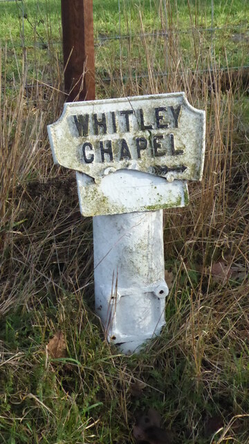
| Church of St Helen | 1045326 | II | 1742 | Whitley Chapel. Built on Medieval site. |
| Churchyard Gates with Piers and Quadrant Walls | 1155671 | II | C20th | |
| Curry Headstone 3.5 Metres East of South-East Corner of Parish Church | 1045327 | II | 1775 | |
| Dotland Park Farmhouse | 1155783 | II* | C15th | Hunting Lodge of Priors of Hexham |
| Farm Buildings to East of Mollersteads Farmhouse | 1303270 | II | C19th | |
| Farmbuildings 20 Metres North of Park House Farmhouse | 1155654 | II | C19th | |
| Farmbuildings 20 Metres West of Black Hall Farmhouse | 1155767 | II | C19th | |
| Farmbuildings Adjacent to Stable Block, and Attached Roadside Wall | 1045335 | II | C19th | |
| Farmbuildings to West of Harwood Shield Farmhouse | 1303364 | II | C18th | Harwood Shield |
| Farmbuildings to West of House | 1370269 | II | C19th | |
| Fox and Hounds Inn (former inn) | 1155706 | II | C18th | Whitley Chapel. Now a private residence. |
| Garden Wall to West of Dukesfield Hall | 1156551 | II | C18th | |
| Garden Walls with Attached Outbuildings and Railings, 150 Metres East of Newbiggin Hall | 1370287 | II | C19th | |
| Gate Lodge, Piers and Walls 100 Metres South-West of Newbiggin Hall | 1155872 | II | c.1830 | |
| Harwood Shield Farmhouse | 1045351 | II | C19th | Harwood Shield |
| Houtley Farmhouse | 1045333 | II | C19th | |
| Low Ardley Farmhouse and Adjacent Farmbuildings | 1155578 | II | C16th | |
| Low Dalton Cottages | 1045350 | II | C18th | Low Dalton |
| Low Rawgreen Farmhouse and Attached Bastle House, and Barn | 1052202 | II | C17th | |
| Low Staples Farmhouse with Garden Wall to South-West and Farmbuildings to East | 1045323 | II | C19th | |
| Methodist Chapel | 1155839 | II | 1865 | Dye House |
| Mile Post on East Side of Road at NGR NY94615988 | 1045329 | II | C20th | North of Ordley |
| Milestone on East Side of Riddlehamhope Track 2.5 Metres South of Bridge | 1155384 | II | C19th | Near Harwood Shield |
| Mollersteads Farmhouse | 1370266 | II | C18th | |
| Newbiggin Hall and Attached Garden Wall to North-East | 1370270 | II | C17th | |
| Nunsbrough 0.5 Km North-East of Ordley | 1045295 | II | 1828 | |
| Old Mill 30 Metres South West of Linnels Bridge | 1045330 | II* | c.1700 | |
| Old Mill at Linnel Dene | 1045334 | II | C17th | |
| Old Smelting Mill 200 Metres South-West of Dukesfield Mill Bridge | 1156558 | II | C18th | |
| Outbuilding 15 Metres North of Hesleywell Farmhouse | 1303375 | II | C16th | Bastle |
| Outbuilding 30 Metres North of Holme House | 1045322 | II | C16th | Bastle |
| Outbuilding to East of the Hall | 1370319 | II | C17th | |
| Park House Farmhouse and Adjacent Outbuilding | 1045324 | II | C19th | |
| Range of Farmbuildings on West Side of Road | 1370288 | II | C16th | |
| Shooting Box | 1045411 | II | C19th | |
| Simpson Headstone 9 Metres South-West of Parish Church Vestry | 1045328 | II | 1917 | |
| Stable Block 70 Metres West of Newbiggin Hall | 1303104 | II | c.1840 | |
| Stobs Cross | 1045325 | II | Medieval | Socket stone |
| Stone House, 200 Metres South-West of Hackford Farm | 1303387 | II | C18th | |
| The Hall | 1302821 | II | C17th | Dukesfield Hall |
| The Heigh Farmhouse | 1045353 | II | C18th | |
| The Old Granary and Attached Wall, 40 Metres South-East of the Hall | 1045277 | II | c.1700 | |
| Turf House Farmhouse | 1155660 | II | C18th | |
| Western House | 1155663 | II | 1755 | |
| Whitehall Methodist Chapel | 1370267 | II | 1871 | |
| Cairnfield 730m south east of Burntshield Haugh | 1018530 | n/a | Prehistoric | Scheduled Monument |
| Hut circle settlement and field system, Romano-British settlement, hush and lead ore works, 750m north east of Burntshield Haugh | 1017959 | n/a | Romano-British | Scheduled Monument |
| Prehistoric hut circle settlement, farmstead and field system, 425m east of Burntshield Haugh | 1017960 | n/a | Prehistoric | Scheduled Monument |
| Burntshieldhaugh Fell prehistoric settlement and field system, 570m east of Ivy Pool | 1017962 | n/a | Prehistoric | Scheduled Monument |
Primary source: the National Heritage List for England - NHLE is the register of nationally protected historic buildings and sites in England, including listed buildings, scheduled monuments, protected wrecks, registered parks and gardens, and battlefields. The list is maintained by Historic England. Check NHLE for updates and new entries. Secondary sources: British Listed Buildings and Keys to the Past.
Co-Curate Page
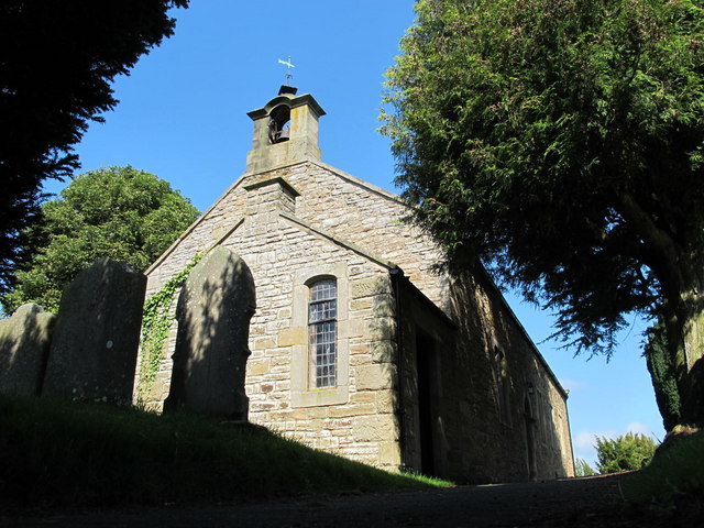
St Helen's Church
- Overview Map St Helen’s Church in Whitley Chapel was built in 1742 on the site of an earlier Medieval building. Abraham Brown, at that time the Master of the Grammar …
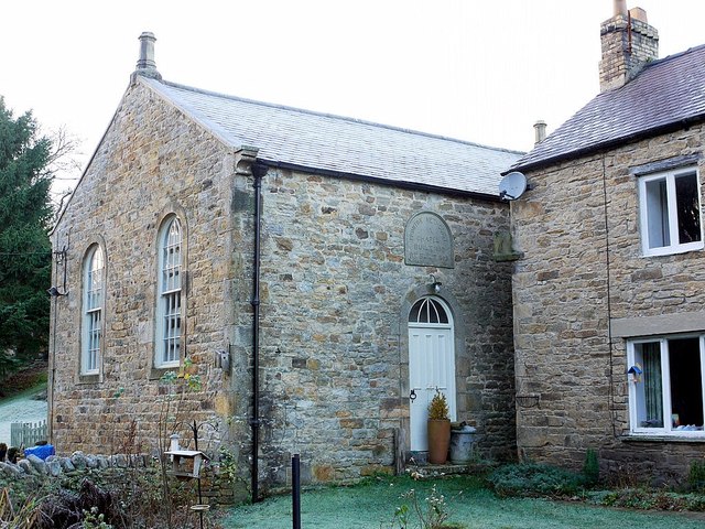
Co-Curate Page
Former Fox and Hounds Inn
- The former Fox and Hounds Inn in Whitley Chapel dates from the 18th century and is Grade II listed on the National Heritage List for England.[1] It is now a private …
Co-Curate Page
Mollersteads
- Overview Map Street View Mollersteads is a farm / hamlet by Rowley Burn, to the east of Whitley Mill and about half a mile north of Whitley Chapel, in Hexhamshire, Northumberland. …
Co-Curate Page
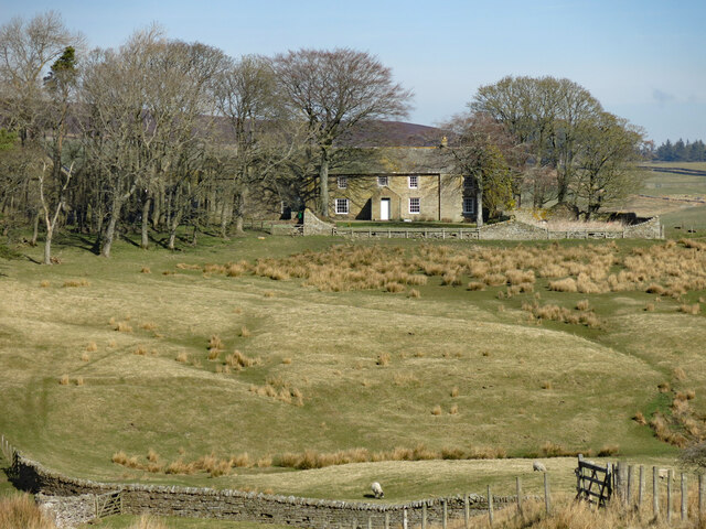
Dotland Park Farmhouse
- Overview Map Street View The farmhouse at Dotland Park was originally a hunting lodge, built in c.1500 by the Priors of Hexham, who had a deer park here. The building …
Co-Curate Page
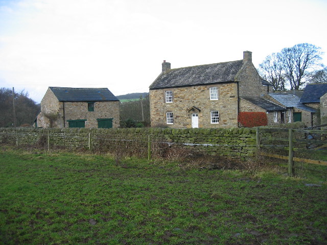
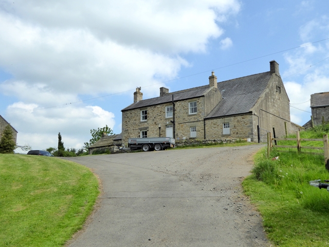
Harwood Shield
- Overview Map Harwood Shield is a farm / hamlet in Northumberland, located about 8 miles south of Hexham and 3½ miles west of Blanchland. The farmhouse here dates from the …
Co-Curate Page
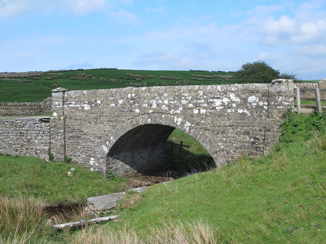
Bridge over Devil's Water, Harwood Shield
- Overview Map The stone segmental arch bridge over Devil's Water, south of Harwood Shield, was built in 1832. The bridge is Grade II listed on the National Heritage List for …
Co-Curate Page
Old Milestone, south of Harwood Shield
- Overview Map To the south of Harwood Shield, near the bridge over Devil's Water, is a 19th century milestone inscrbed "R 1 M" - indicating 1 mile to Riddlehamhope. The …
Co-Curate Page
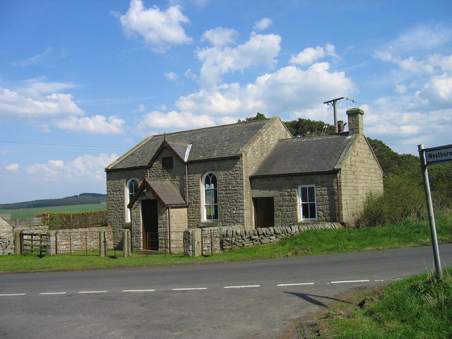
Whitehall Methodist Church, Hexhamshire
- Overview Map Street View Whitehall Methodist Church is located about 2 miles south-west of the village of Whitley Chapel, in Northumberland. It was originally built as a Wesleyan chapel in …
Co-Curate Page
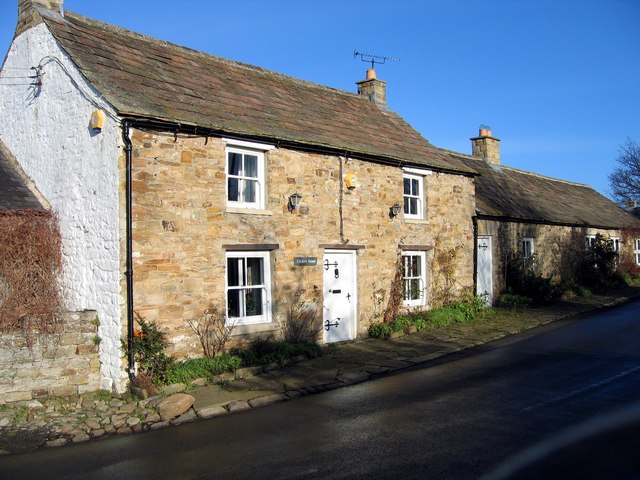
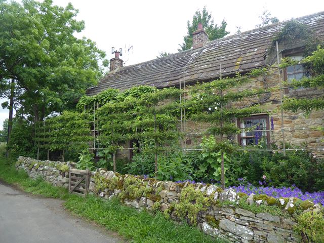
Low Dalton Cottages
- Overview Map Street View Nos. 1, 2 & 3 Low Dalton Cottages date from the 18th century and earlier. The western cottage dates from the 17th century, though largely rebuilt …
Co-Curate Page
Old Milepost north of Ordley, Hexhamshire
- Overview Map Street View This old milepost is located about ¼mile north of Ordley on the road to Newbiggin, in Hexhamshire. The cast-iron milepost, by Smith Paterson Ltd, of Blaydon, …
Co-Curate Page
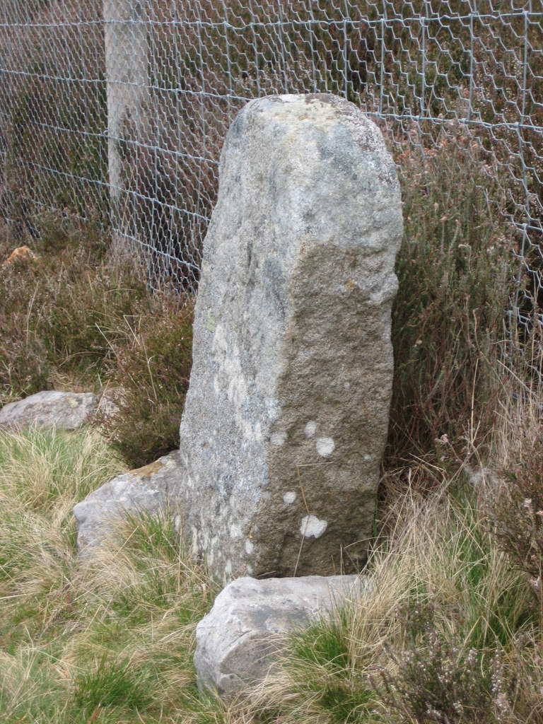
Old Boundary Marker, Dukesfield Fell, Slaley
- Overview Map This old estate boundary marker is located on Dukesfield Fell, on the edge of Slaley Forest. It dates from around the 18th century, and sits on the boundary …

Co-Curate Page
Bridge over Linn Burn
- Overview Map This bridge over Linn Burn is located on Allendale Common, about 2 miles east of Sinderhope. It dates from the late 18th century and was part of the …

Co-Curate Page
St Helen's Church
- Overview Map St Helen’s Church in Whitley Chapel was built in 1742 on the site of an earlier Medieval building. Abraham Brown, at that time the Master of the Grammar …
Co-Curate Page
Former Fox and Hounds Inn
- The former Fox and Hounds Inn in Whitley Chapel dates from the 18th century and is Grade II listed on the National Heritage List for England.[1] It is now a private …
Co-Curate Page
Mollersteads
- Overview Map Street View Mollersteads is a farm / hamlet by Rowley Burn, to the east of Whitley Mill and about half a mile north of Whitley Chapel, in Hexhamshire, Northumberland. …
Co-Curate Page
Dotland Park Farmhouse
- Overview Map Street View The farmhouse at Dotland Park was originally a hunting lodge, built in c.1500 by the Priors of Hexham, who had a deer park here. The building …
Co-Curate Page
Harwood Shield
- Overview Map Harwood Shield is a farm / hamlet in Northumberland, located about 8 miles south of Hexham and 3½ miles west of Blanchland. The farmhouse here dates from the …
Co-Curate Page
Bridge over Devil's Water, Harwood Shield
- Overview Map The stone segmental arch bridge over Devil's Water, south of Harwood Shield, was built in 1832. The bridge is Grade II listed on the National Heritage List for …
Co-Curate Page
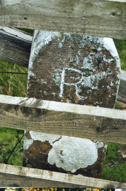
Old Milestone, south of Harwood Shield
- Overview Map To the south of Harwood Shield, near the bridge over Devil's Water, is a 19th century milestone inscrbed "R 1 M" - indicating 1 mile to Riddlehamhope. The …
Co-Curate Page
Whitehall Methodist Church, Hexhamshire
- Overview Map Street View Whitehall Methodist Church is located about 2 miles south-west of the village of Whitley Chapel, in Northumberland. It was originally built as a Wesleyan chapel in …
Co-Curate Page
Low Dalton Cottages
- Overview Map Street View Nos. 1, 2 & 3 Low Dalton Cottages date from the 18th century and earlier. The western cottage dates from the 17th century, though largely rebuilt …
Co-Curate Page
Old Milepost north of Ordley, Hexhamshire
- Overview Map Street View This old milepost is located about ¼mile north of Ordley on the road to Newbiggin, in Hexhamshire. The cast-iron milepost, by Smith Paterson Ltd, of Blaydon, …
Co-Curate Page
Old Boundary Marker, Dukesfield Fell, Slaley
- Overview Map This old estate boundary marker is located on Dukesfield Fell, on the edge of Slaley Forest. It dates from around the 18th century, and sits on the boundary …


