Topics > Northumberland > Civil Parishes in Northumberland > Ford Civil Parish > Historic Buildings and Monuments in Ford CP
Historic Buildings and Monuments in Ford CP
Listed buildings and scheduled monuments in Ford Civil Parish, Northumberland, from the National Heritage List for England[1]. Use the Search (below) if looking for a specific building / monument.
| Structure | List No. | Grade | Built~ | Location | Note |
|---|---|---|---|---|---|
| Battle of Flodden 1513 | 1000011 | n/a | 1513 | Historic Battlefield (falls in Branxton, Carham and Ford parishes) | |
| Ford Colliery 920m north east of Blackcrag Wood | 1020746 | n/a | C17th | Ford Moss | Scheduled Monument |
| Ford Westfield settlement | 1006423 | n/a | Romano-British | Scheduled Monument | |
| No. 13 Ford Village | 1370990 | II | C19th | Ford | |
| No. 14 Ford Village | 1042156 | II | C19th | Ford | |
| 2 Neville Gravestones Circa 5 Yards North West of Church of St Michael | 1154144 | II | 1895 | Ford | |
| Nos. 8, 10, 12 Ford Village | 1370991 | II | C19th | Ford | |
| Apple Store Circa 60 Yards West of Pallinsburn | 1042163 | II | C18th | Pallinsburn | |
| Black Grave Circa 20 Yards North East of Church of St Michael | 1042151 | II | 1833 | Ford | |
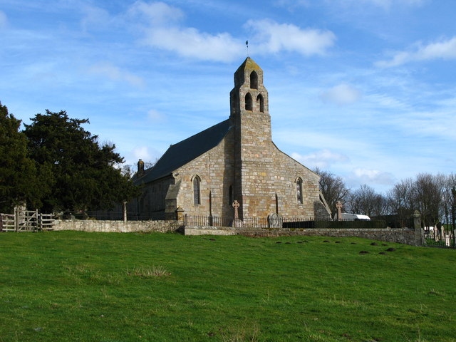
| Church of St Mary the Virgin | 1042179 | II | 1858 | Etal | |
| Church of St Michael and All Angels | 1371006 | II* | C13th | Ford | Restored by John Dobson 1853 |
| Colliery Engine House Chimney | 1154125 | II | C19th | nr. Ford | Ford Moss Colliery |
| Crookham Cottage | 1153900 | II | C17th | Crookham | |
| Crookham Manse and Attached Garden Wall | 1371003 | II | c.1750 | Crookham | |
| East Lodge | 1154360 | II | 1840 | ||
| Encampment Farmhouse | 1042178 | II | 1780 | ||
| Etal Castle Gate Tower, South Curtain Wall and South West Tower | 1153966 | I | C14th | Etal | Licence to crenellate 1342 |
| Etal Castle Great Tower | 1042183 | I | 1341 | Etal | Scheduled Monument (1011644) |
| Etal Manor | 1153945 | II* | 1748 | Etal | |
| Etal Rhodes Farmhouse | 1154010 | II | C18th | Etal | |
| Flodden Lodge | 1042175 | II | 1865 | ||
| Ford Bridge | 1042176 | II | 1809 | Ford | Incorporating an arch from an earlier C16th bridge |
| Ford Castle | 1371004 | I | C14th | Ford | |
| Ford Castle East Gateway, East Forecourt Wall and Handyman's Cottage | 1154087 | II* | 1791 | Ford | Cottage added c.1862 |
| Ford Castle Flagpole Tower and Forecourt Wall Attached to North | 1154034 | I | C14th | Ford | Licence to crenellate 1338 |
| Ford Castle Game Tower with Attached Garden Walls and Carriage Arch | 1154099 | II | C19th | Ford | |
| Ford Castle North Forecourt Wall and Gateway with Laundry and Service Wing Attached to Rear | 1042186 | II* | 1791 | Ford | |
| Ford Castle Portcullis Gate, Armoury Tower and Forecourt Walls to Ford Castle | 1042185 | I | 1791 | Ford | Incorporating earlier materials |
| Ford Castle Terrace Walls to West and North West of Ford Castle | 1303985 | II | 1870 | Ford | |
| Ford Castle the Dene Bridge | 1371005 | II | 1870 | Ford | |
| Ford Castle Walled Garden Circa 60 Yards East of Ford Castle | 1042187 | II | C19th | Ford | |
| Ford Forge | 1042159 | II | 1767 | Ford | |
| Ford Smithy | 1042157 | II | 1863 | Ford | |
| Former Cart Shed Circa 30 Yards West of Heatherslaw Mill | 1303909 | II | C18th | Heatherslaw | |
| Former Presbyterian Church | 1153983 | II | 1800 | ||
| Former Presbyterian Manse | 1042184 | II | C18th | ||
| Garden Wall and Gatepiers Circa 3 Yards North of Number 14 | 1370992 | II | C19th | Ford | |
| Garden Wall and Gatepiers Circa 3 Yards South of Number 13 | 1042154 | II | C19th | Ford | |
| Garden Walls and Gatepiers in Front of Encampment Farmhouse | 1304056 | II | |||
| Gates and Gate Piers Circa 150 Yards North West of Pallinsburn | 1154354 | II | Pallinsburn | ||
| Gates, Gatepiers and Railings Circa 1 Mile South of Etal Manor | 1153954 | II | |||
| Gates, Gatepiers and Steps Circa 50 Yards South of Church of St Michael | 1042152 | II | Ford | ||
| Gingang and Attached Threshing Barn at West Flodden Farmhouse | 1154374 | II | |||
| Gravestone of Louisa, Marchioness of Waterford, Circa 10 Yards West of Church of St Michael | 1042188 | II | Ford | ||
| Heatherslaw Bridge | 1154240 | II | Heatherslaw | ||
| Heatherslaw Mill | 1042160 | II | C18th | Heatherslaw | |
| High Kiln with Attached Gift Shop at Heatherslaw Mill | 1042161 | II | |||
| Joiner's Shop Circa 60 Yards East of Pallinsburn | 1303870 | II | |||
| Jubilee Cottage | 1154205 | II | |||
| Lady Waterford Hall | 1042153 | II* | 1860 | Ford | |
| Mardon Farmhouse | 1154288 | II | |||
| Milepost About 1/4 Mile North East of Ford Village | 1304088 | II | |||
| Milepost at Berryhill Road End | 1042177 | II | |||
| Milepost Beside Ford Castle West Lodge | 1371002 | II | Ford | ||
| Milepost by the Blue Bell | 1304081 | II | |||
| Milepost Circa 1/4 Mile South East of Barelees | 1304073 | II | |||
| Milepost Circa 1/4 Mile South of Pallinsburn | 1371000 | II | |||
| Milepost Circa 100 Yards North of Hay Farm Road End | 1153914 | II | |||
| Milepost Circa 200 Yards West of Mount Pleasant | 1042174 | II | |||
| Milepost Circa 50 Yards North of Junction with B6352 | 1304084 | II | |||
| Milepost in Etal Village | 1042182 | II | Etal | ||
| Monument Circa 50 Yards East of Etal Manor | 1042180 | II | c.1850 | Etal | |
| Old Farmhouse | 1042158 | II | 1780 | ||
| Pallinsburn House | 1042162 | II* | C18th | Pallinsburn | County House |
| Parson's Tower | 1370989 | II | Medieval | Ford | Pele to wer (ruins). Scheduled Monument(1018372) |
| Range of Farmbuildings to North of Old Farmhouse | 1154231 | II | |||
| Stable Block About 40 Yards North of Etal Manor | 1042181 | II | Etal | ||
| Sundial Circa 10 Yards North of Pallinsburn | 1370993 | II | Pallinsburn | ||
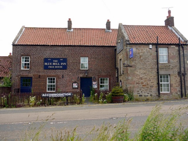
| The Blue Bell | 1371001 | II | C18th | Pallinsburn | |
| The Waterford Fountain | 1154211 | II | c.1860 | Ford | |
| Village Pump Beside the United Reformed Church | 1304052 | II | |||
| Wall and Gatepiers at West Lodge | 1154368 | II | |||
| Wall and Railings Circa 160 Yards North West of Pallinsburn | 1042164 | II | Pallinsburn | ||
| Watchlaw Farmhouse | 1370994 | II | |||
| Well Circa 20 Yards South of Lady Waterford Hall | 1042155 | II | |||
| West Lodge | 1042165 | II | |||
| West Lodge and Gateway to Ford Castle | 1153904 | II | Ford | ||
| Rock art at Goatscrag, 200m north west of Routin Lynn | 1418572 | n/a | Prehistoric | Scheduled Monument | |
| Rock art including four animal carvings at Goatscrag rock shelter, 155m north west of Routin Lynn | 1417671 | n/a | Prehistoric | Scheduled Monument | |
| The King's Stone NW of Crookham Westfield Farm | 1002906 | n/a | Prehistoric | Scheduled Monument. Reputedly where King James IV was killed at the Battle of Flodden. | |
| Hazely Hill round cairn | 1002948 | n/a | Bronze Age | Scheduled Monument. Burial Mound | |
| Defended settlement on White Hill, 700m south east of Kimmerston | 1006408 | n/a | Iron Age | Scheduled Monument | |
| Circular enclosure W of Second Linthaugh | 1006430 | n/a | Scheduled Monument | ||
| Camp 400yds (370m) NNE of Flodden | 1006445 | n/a | Romano-British | Scheduled Monument | |
| Flodden Edge camp | 1006449 | n/a | Iron Age | Scheduled Monument | |
| Flodden camp | 1006481 | n/a | Scheduled Monument | ||
| Fordwood camp, Broomridge Dean | 1006522 | n/a | Iron Age | Scheduled Monument | |
| Two incised rocks on Broom Ridge, Hunter's Moor | 1006554 | n/a | Scheduled Monument |
Primary source: the National Heritage List for England - NHLE is the register of nationally protected historic buildings and sites in England, including listed buildings, scheduled monuments, protected wrecks, registered parks and gardens, and battlefields. The list is maintained by Historic England. Check NHLE for updates and new entries. Secondary sources: British Listed Buildings and Keys to the Past.
Co-Curate Page
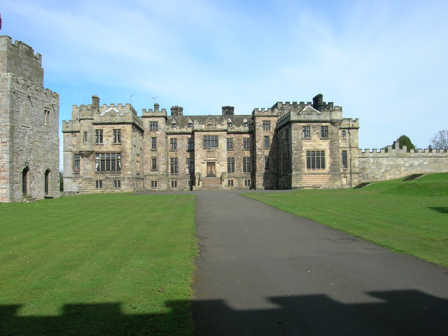
Ford Castle
- Overview About Ford Castle Map Inside Street View "Ford Castle has its origins in the 14th century. Sir William Heron was given permission to fortify his residence here in 1338 …
Co-Curate Page
Etal Castle
- Overview About Etal Castle Map Street View Etal Castle was built c.1341, by Robert Manners. The ruined medieval castle is located in the village of Etal, in Northumberland. Etal castle …
Co-Curate Page
Lady Waterford Hall
- Overview About the Hall Map Street View Lady Waterford Hall is located in Ford in Northumberland. The building was commissioned in 1860 by Louisa Anne, the Marchioness of Waterford, and …
Co-Curate Page
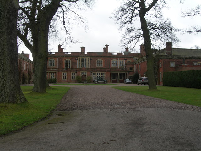
Etal Manor
- Overview Map A large country house in Etal, Northumberland, built in 1748. It was extended in 1767 for William Carr, and again in 1888 for James Laing. The Manor is …
Co-Curate Page
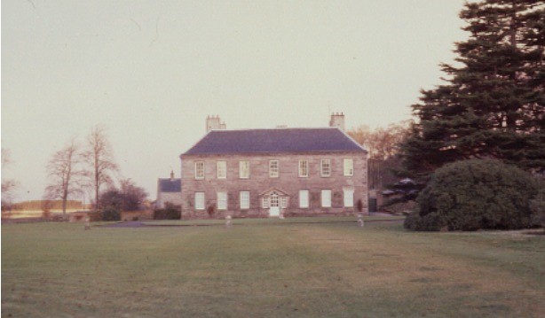
Pallinsburn House
- Overview About Pallinsburn House Map Street View Pallinsburn House is an 18th-century country house situated at Ford, Northumberland. It is Grade II* listed on the National Heritage List for England. …
Co-Curate Page
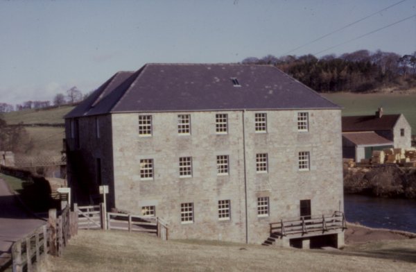
Heatherslaw Mill
- Overview Map Street View An 18th century watermill by the River Till in Heatherlaw, near Etal, in Northumberland. It is a double mill with two water wheels. The mill is …
Co-Curate Page
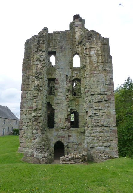
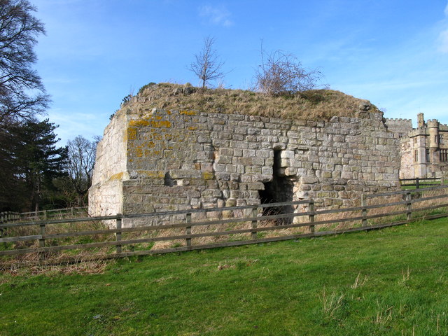
Parson's Tower, Ford
- Overview Map Street View Parson's Tower in Ford, Northumberland, are the remains of a Medieval pele tower. It is located in a field south-west of Ford Castle and north-west of …
Co-Curate Page
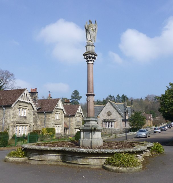
Waterford Fountain, Ford
- Overview Map Street View "This fountain is placed by Louisa Marchioness of Waterford in grateful and affectionate remembrance of her husband Henry 3rd Marquis of Waterford K.P. Born April 25th …

Co-Curate Page
Battle of Flodden, 1513
- Overview About the Battle Map of the Battlefield The Battle of Flodden (or Flodden Field) near Branxton was fought between the English and the invading Scottish army on the 9th …
Co-Curate Page
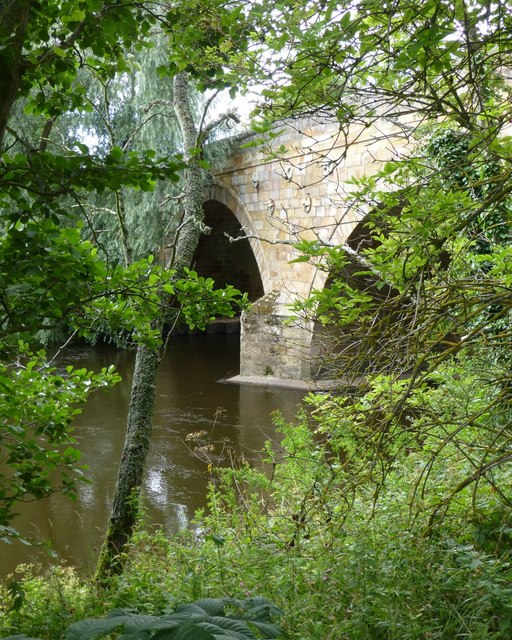
Ford Bridge
- Overview Map Street View Ford Bridge carries the B6353 road over the River Till, about half a mile west of Ford village. The current bridge was built in 1809, but …
Co-Curate Page
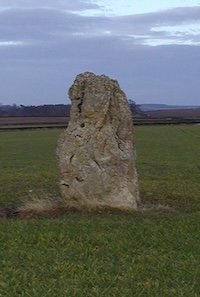
The King's Stone NW of Crookham Westfield
- The King's Stone, to the north-west of Crookham Westfield in Northumberland, is a standing stone of either late Neolithic or early Bronze Age date. It is formed from cherty magnesium …

Co-Curate Page
Defended settlement on White Hill, SE of Kimmerston
- Map showing Kimmerson with the Scheduled Monument area to the south east. The cropmarked remains of a multivallate defended settlement are located 590m south-east of Kimmerston in Northumberland. Situated on …

Co-Curate Page
Ford Colliery
- Scheduled Monument areas - based on Historic England data (Open Government Licence). Ford Colliery was located by Ford Moss, to the east of the village of Ford, in Northumberland. It …

Co-Curate Page
Ford Castle
- Overview About Ford Castle Map Inside Street View "Ford Castle has its origins in the 14th century. Sir William Heron was given permission to fortify his residence here in 1338 …
Co-Curate Page
Etal Castle
- Overview About Etal Castle Map Street View Etal Castle was built c.1341, by Robert Manners. The ruined medieval castle is located in the village of Etal, in Northumberland. Etal castle …
Co-Curate Page
Lady Waterford Hall
- Overview About the Hall Map Street View Lady Waterford Hall is located in Ford in Northumberland. The building was commissioned in 1860 by Louisa Anne, the Marchioness of Waterford, and …
Co-Curate Page
Etal Manor
- Overview Map A large country house in Etal, Northumberland, built in 1748. It was extended in 1767 for William Carr, and again in 1888 for James Laing. The Manor is …
Co-Curate Page
Pallinsburn House
- Overview About Pallinsburn House Map Street View Pallinsburn House is an 18th-century country house situated at Ford, Northumberland. It is Grade II* listed on the National Heritage List for England. …
Co-Curate Page
Heatherslaw Mill
- Overview Map Street View An 18th century watermill by the River Till in Heatherlaw, near Etal, in Northumberland. It is a double mill with two water wheels. The mill is …
Co-Curate Page
Parson's Tower, Ford
- Overview Map Street View Parson's Tower in Ford, Northumberland, are the remains of a Medieval pele tower. It is located in a field south-west of Ford Castle and north-west of …
Co-Curate Page
Waterford Fountain, Ford
- Overview Map Street View "This fountain is placed by Louisa Marchioness of Waterford in grateful and affectionate remembrance of her husband Henry 3rd Marquis of Waterford K.P. Born April 25th …
Co-Curate Page
Battle of Flodden, 1513
- Overview About the Battle Map of the Battlefield The Battle of Flodden (or Flodden Field) near Branxton was fought between the English and the invading Scottish army on the 9th …
Co-Curate Page
Ford Bridge
- Overview Map Street View Ford Bridge carries the B6353 road over the River Till, about half a mile west of Ford village. The current bridge was built in 1809, but …
Co-Curate Page
The King's Stone NW of Crookham Westfield
- The King's Stone, to the north-west of Crookham Westfield in Northumberland, is a standing stone of either late Neolithic or early Bronze Age date. It is formed from cherty magnesium …
Co-Curate Page
Defended settlement on White Hill, SE of Kimmerston
- Map showing Kimmerson with the Scheduled Monument area to the south east. The cropmarked remains of a multivallate defended settlement are located 590m south-east of Kimmerston in Northumberland. Situated on …


