Topics > Northumberland > Civil Parishes in Northumberland > Bamburgh Civil Parish > Historic Buildings and Monuments in Bamburgh
Historic Buildings and Monuments in Bamburgh
This page includes historic buildings, monuments, and sites in Bamburgh Civil Parish in Northumberland, compiled from two sources: a) Listed buildings and scheduled monuments, from the National Heritage List for England[1]. b) the Proposed List of Non designated Heritage Assets of Local Importance ('Local List') from the Bamburgh, Seahouses and Beadnell Neighbourhood Plan.[2] Use the Search in the data table (below) if looking for a specific building / monument.
| Structure | List No. | Grade | Built~ | Notes |
|---|---|---|---|---|
| Nos. 1-6, Armstrong Cottages | 1280180 | II | 1894 | Links Road |
| Nos. 1-7, The Wynding | 1276783 | II | 1906 | The Wynding |
| Nos. 12, 13 and 14, Armstrong Cottages | 1206570 | II | C18th | Front Street |
| Nos. 12 and 13, Front Street | 1276947 | II | 1894 | Links Road |
| Nos. 15 and 16, Armstrong Cottages | 1042268 | II | 1894 | Links Road |
| Nos. 17-22, Front Street | 1232829 | II | 1809 | Front Street |
| No. 5, Radcliffe Road | 1276804 | II | C18th | Radcliffe Road |
| No. 7, Radcliffe Road | 1276951 | II | C18th | Radcliffe Road |
| No. 8, Front Street | 1232744 | II | C18th | Front Street |
| Nos. 9 and 10, Front Street | 1276946 | II | 1699 | Front Street |
| Armstrong House | 1232749 | II | 1925 | Front Street |
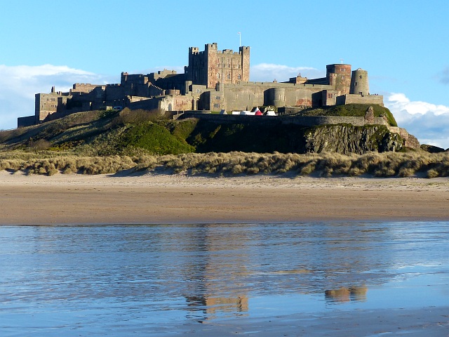
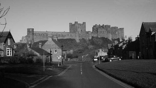
| Bamburgh Castle | 1280155 | I | C12th | Restored C19th for Lord Armstrong |
| Bamburgh Hall | 1232741 | II | C17th | Church Street |
| Bamburgh House | 1232746 | II | c.1840 | Front Street |
| Blacksmiths Forge | 1232751 | II | C18th | Ingram Road |
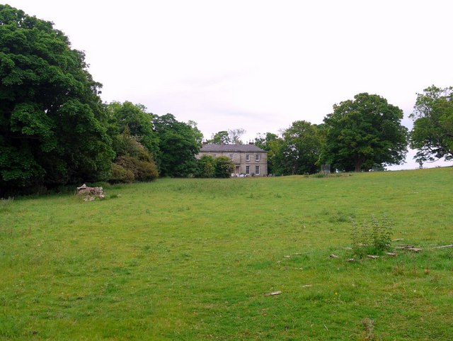
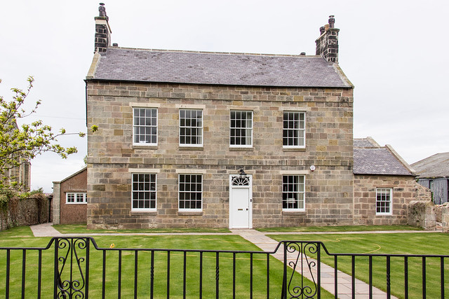
| Budle Hall | 1280158 | II* | 1810 | Budle |
| Canisbay Cottage | 1042267 | II | 1894 | Two cottages |
| Cartshed at Friary Farm | 1276805 | II | C19th | Radcliffe Road |
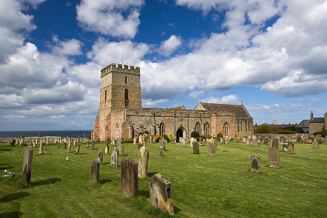
| Church of St Aidan | 1042269 | I | C12th | |
| Churchyard Wall and Gateway East and South of Church of St Aidan | 1042270 | II | Medieval | Church Street |
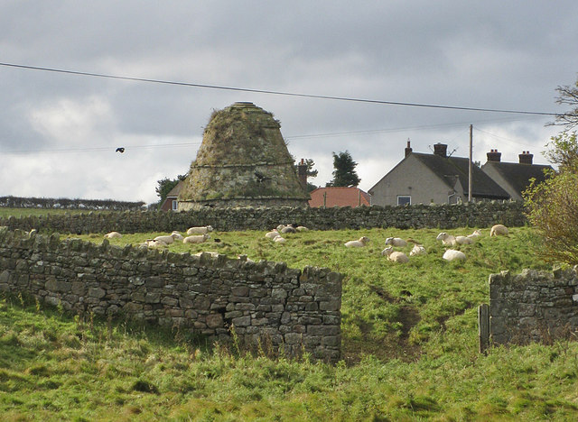
| Dovecote Circa 50 Yards South of Armstrong House | 1232923 | II* | C16th | Scheduled Monument(1006571) |
| Dukesfield Farmhouse | 1232742 | II | c.1820 | |
| Farmbuildings at Friary Farm | 1276913 | II | C18th | Radcliffe Road |
| Farmbuildings Circa 50 Yards North East of Bamburgh Hall | 1276944 | II | C19th | Church Street |
| Garden Wall Attached to South of Number 16 (Bamburgh House) | 1232747 | II | c.1840 | Front Street |
| Gatepiers and Garden Wall Circa 15 Yards East of the Friars | 1276782 | II | C19th | Radcliffe Road |
| Glororum Farmhouse | 1232750 | II | c.1830 | Glororum |
| Mackenzie and Robb Graves Circa 50 Yards South West of Church of at Aidan | 1276943 | II | 1838 | |
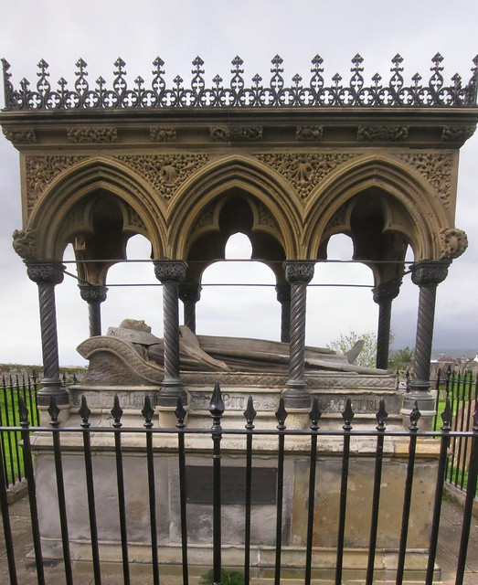
| Monument to Grace Darling Circa 30 Yards West of Church of St Aidan | 1206625 | II* | 1842 | |
| Pant and Trough at East End of the Grove | 1276950 | II | C19th | The Grove |
| The Castle Hotel | 1276945 | II | C18th | Front Street |
| The Friars | 1232752 | II | 1830 | Radcliffe Road |
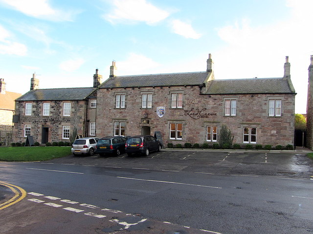
| The Lord Crewe Arms | 1276949 | II | C19th | Front Street |
| The Pinfold | 1233047 | II | C18th | The Wynding |
| The Post Office | 1232748 | II | 1891 | Front Street |
| The Toby Jug Restaurant | 1232849 | II | C19th | Front Street. Now part of The Lord Crewe. |
| The Village House | 1232745 | II | C18th | Front Street, No. 11 |
| The Village Store | 1232846 | II | C18th | Front Street, Nos 25 & 26 |
| Walled Garden at West End of the Grove | 1276803 | II | 1693 | The Grove |
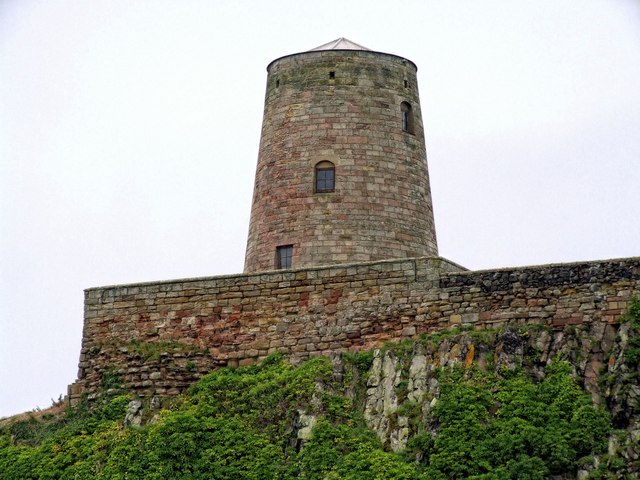
| Windmill at North End of Bamburgh Castle | 1370967 | II | C18th | |
| Wynding House | 1233046 | II | C18th | The Wynding |
| Budle Deserted Medieval Village | - | Local | ||
| Budle Bay Stone Crushing Plant | - | Local | C20th | |
| Newtown Gun Emplacement | - | Local | C20th | |
| Harkness Rocks Pillbox | - | Local | ||
| D Shaped Pillbox | - | Local | ||
| Mound/Hillock | - | Local | ||
| Bowl Hole | - | Local | ||
| Burton Quarry Limekiln | - | Local | ||
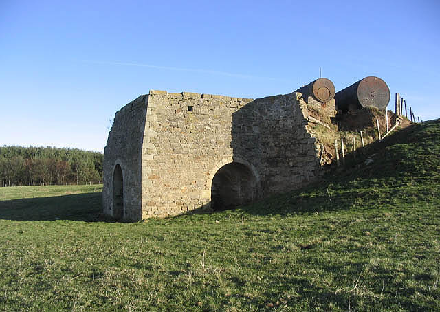
| Glororum Limekiln | - | Local | Glororum | |
| Greenhill Rocks Pillbox | - | Local | ||
| Greenhill Links Pillbox | - | Local | ||
| Royal Observer Corps Monitoring Post | - | Local | ||
| Lozenge Pillbox | - | Local | ||
| Pier in Budle Bay | - | Local | C19th | |
| Harkness Rocks Tank Traps | - | Local | ||
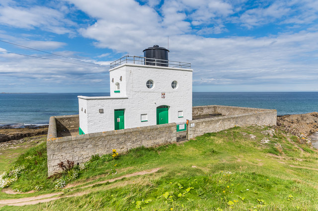
| Blackrocks Point Lighthouse | - | Local | 1910 | |
| Greenhill Links Pillbox Ruins | - | Local | ||
| Bamburgh War Memorial | - | Local | ||
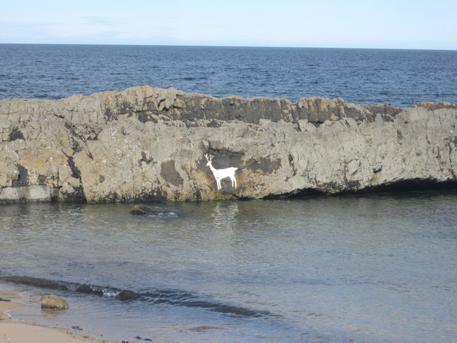
| Stag Rock | - | Local | on Harkess Rocks, Bamburgh | |
| Nos. 1 - 7, Ingram Road | - | Local | ||
| No. 12 Ingram Road | - | Local | ||
| Nos. 1 - 6 South Victoria Terrace | - | Local | ||
| The Victoria | - | Local | C19th | Front Street. Hotel. |
| The Mortuary | - | Local | ||
| Veeras Cottage | - | Local | ||
| Red Barns Farmhouse | - | Local | ||
| The Gas House | - | Local | ||
| Woodbine Cottage | - | Local | ||
| Eightbells Cottages | - | Local | ||
| Coastguard Cottages | - | Local | ||
| Lifeboat House | - | Local | ||
| Bamburgh Golf Clubhouse | - | Local | ||
| Bathing Hut | - | Local | ||
| School House | - | Local | ||
| Rose Cottage | - | Local | ||
| The School House | - | Local | ||
| Grove Cottage | - | Local | ||
| No. 1 Radcliffe Cottage | - | Local | ||
| The Glebe | - | Local | ||
| Bamburgh Conservation Area | - | n/a | - | Conservation Area |
1. Primary source: the National Heritage List for England - NHLE is the register of nationally protected historic buildings and sites in England, including listed buildings, scheduled monuments, protected wrecks, registered parks and gardens, and battlefields. The list is maintained by Historic England. Check NHLE for updates and new entries. Secondary sources: British Listed Buildings and Keys to the Past
2. Non designated Heritage Assets of Local Importance - Bamburgh, Seahouses and Beadnell Neighbourhood Plan, April 2016. Check Bamburgh Parish Council for updates and new entries.
Co-Curate Page
Grace Darling Memorial
- The memorial to Grace Darling (1815 - 1842) stands in the churchyard of St Aidan's Church in Bamburgh. The memorial was built in 1842, in a Gothic Revival style designed by …
Co-Curate Page
Church of St Aidan
- Overview About St Aidan's Church Map Street View St Aiden's Church in Bambrugh was built in the 12th century on the site of an earlier church. According to Bede, St …
Co-Curate Page
Bamburgh Castle
- Overview About Bamburgh Castle Map Inside Street View Bamburgh Castle is a castle on the northeast coast of England, by the village of Bamburgh in Northumberland. It is Grade …
Co-Curate Page
Budle Hall
- Overview Map Street View Budle Hall is a country house in Budle, about 1 mile west of Bamburgh in Northumberland. It was built in c.1810 for Mr. Grieve Smith. Today, …
Co-Curate Page
Blackrocks Point Lighthouse
- Overview About the Lighthouse Map Street View Blackrocks Point Lighthouse (aka Bamburgh Lighthouse) was built by Trinity House in 1910 to guide shipping along the Northumberland coast and in the …
Co-Curate Page
Stag Rock, near Blackrocks Point
- Overview Map Street View Stag Rock is located near the lighthouse at Blackrocks Point, about half mile north-east of Bamburgh. It's exact history is unknown, but the area has been …
Co-Curate Page
Windmill at Bamburgh Castle
- The windmill at the north end of Bamburgh Castle was built in the mid 18th century and is Grade II listed on the National Heritage List for England.
Co-Curate Page
Dovecote
- There is a 16th/17th century dovecote at Bamburgh. The dovecote is Grade II* listed on the National Heritage List for England.
Co-Curate Page
Bamburgh
- Overview About Bamburgh Map Street View Bamburgh is a large village and civil parish on the coast of Northumberland, England. It had a population of 454, decreasing to 414 …
Co-Curate Page
The Lord Crewe, Bamburgh
- Overview Map Street View The Lord Crewe is a hotel and restaurant located on Front Street (No. 27), in Bamburgh. The building dates from the mid 19th century and incorporates …

Co-Curate Page
The Victoria Hotel, Bamburgh
- The Victoria Hotel is located on the corner of Front Street and Ingram Road in Bamburgh. The building appears to be 19th century in origin. The hotel is included in …
Co-Curate Page
Bamburgh Hall
- Overview Map Street View Bamburgh Hall is located on Church Street, next to St Aiden's Church, in Bamburgh. The house dates from the 17th century and was refronted in the …
Co-Curate Page
Burton Quarry Limekiln
- Overview Map There is an old limekiln at Burton, near Bamburgh, by the former Burton Quarry. It appears to be of 19th century in origin, with 3 draw arches, with …

Co-Curate Page
Grace Darling Memorial
- The memorial to Grace Darling (1815 - 1842) stands in the churchyard of St Aidan's Church in Bamburgh. The memorial was built in 1842, in a Gothic Revival style designed by …
Co-Curate Page
Church of St Aidan
- Overview About St Aidan's Church Map Street View St Aiden's Church in Bambrugh was built in the 12th century on the site of an earlier church. According to Bede, St …
Co-Curate Page
Bamburgh Castle
- Overview About Bamburgh Castle Map Inside Street View Bamburgh Castle is a castle on the northeast coast of England, by the village of Bamburgh in Northumberland. It is Grade …
Co-Curate Page
Budle Hall
- Overview Map Street View Budle Hall is a country house in Budle, about 1 mile west of Bamburgh in Northumberland. It was built in c.1810 for Mr. Grieve Smith. Today, …
Co-Curate Page
Blackrocks Point Lighthouse
- Overview About the Lighthouse Map Street View Blackrocks Point Lighthouse (aka Bamburgh Lighthouse) was built by Trinity House in 1910 to guide shipping along the Northumberland coast and in the …
Co-Curate Page
Stag Rock, near Blackrocks Point
- Overview Map Street View Stag Rock is located near the lighthouse at Blackrocks Point, about half mile north-east of Bamburgh. It's exact history is unknown, but the area has been …
Co-Curate Page
Windmill at Bamburgh Castle
- The windmill at the north end of Bamburgh Castle was built in the mid 18th century and is Grade II listed on the National Heritage List for England.
Co-Curate Page
Dovecote
- There is a 16th/17th century dovecote at Bamburgh. The dovecote is Grade II* listed on the National Heritage List for England.
Co-Curate Page
Bamburgh
- Overview About Bamburgh Map Street View Bamburgh is a large village and civil parish on the coast of Northumberland, England. It had a population of 454, decreasing to 414 …
Co-Curate Page
The Lord Crewe, Bamburgh
- Overview Map Street View The Lord Crewe is a hotel and restaurant located on Front Street (No. 27), in Bamburgh. The building dates from the mid 19th century and incorporates …
Co-Curate Page
The Victoria Hotel, Bamburgh
- The Victoria Hotel is located on the corner of Front Street and Ingram Road in Bamburgh. The building appears to be 19th century in origin. The hotel is included in …
Co-Curate Page
Bamburgh Hall
- Overview Map Street View Bamburgh Hall is located on Church Street, next to St Aiden's Church, in Bamburgh. The house dates from the 17th century and was refronted in the …
")
