Topics > Heritage Sites > Scheduled Monument > Scheduled Monuments in Cumberland
Scheduled Monuments in Cumberland
Some of the Scheduled Monuments on this Website which are located in the Cumberland Council area.
Scheduled Monuments are sites of national significance which have been given the top-level of legal protection under the Ancient Monuments and Archaeological Areas Act 1979. They range from archaeological sites (prehistoric, Roman, Medieval etc) to ruins or surviving structures (including some 19th/20th century industrial and military sites).

Co-Curate Page
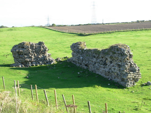
Bastle at Upper Denton
- There is roofless bastle standing two storeys high located at the northern end of the village of Upper Denton. It is constructed of squared coursed rubble with red sandstone dressings. …
Co-Curate Page
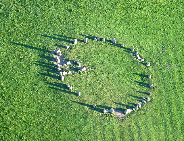
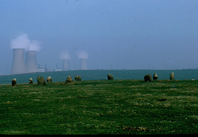
Castlerigg Stone Circle
- Overview About Castlerigg Stone Circle Map Street View Castlerigg Stone Circle, located just over a mile east of Keswick, is one of the earliest stone circles in the UK, thought …
Co-Curate Page
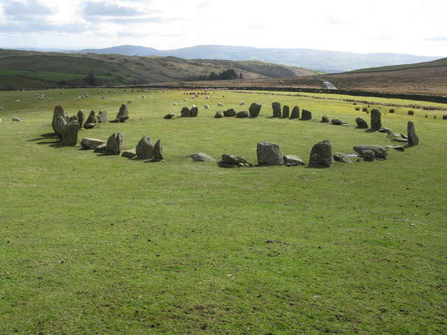
Swinside Stone Circle
- Overview About Swinside Stone Circle Map Street View Swinside Stone Circle (also known as Sunkenkirk Stone Circle) is a stone circle from either the Neolithic or Bronze Age date, located …
Co-Curate Page
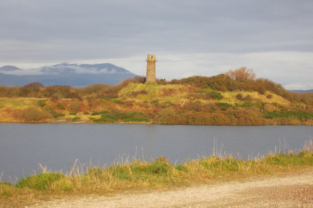
Hodbarrow Old Lighthouse
- The old lighthouse (aka Hodbarrow Beacon) is located 380m north-west of Hodbarrow Point, to the south of Millom. Built in the 19th Century, it is one of the last surviving …
Co-Curate Page
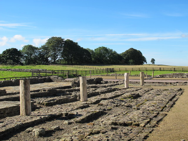
Birdoswald Roman Fort (Banna)
- Overview Map Street View Hadrian's Wall Glossary Birdoswald Roman Fort (known as Banna) is situated on the western part of Hadrian's Wall, about 1 mile west of Gilsland in Cumbria. …
Co-Curate Page
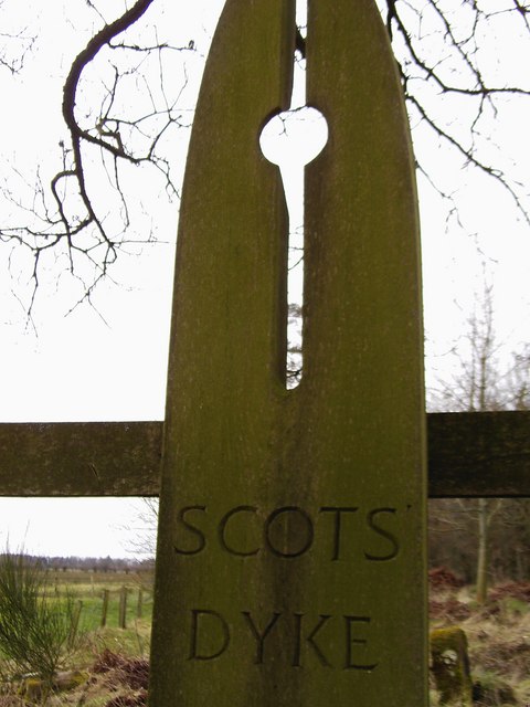
Scots Dyke
- Scots Dyke (aka Scots' Dike) is a 3½ mile long earthwork, constructed by the English and the Scots in 1552 to mark the division of the 'Debatable Lands' which had …
Co-Curate Page
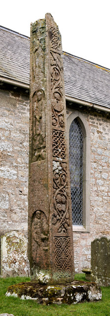
Medieval Bewcastle Cross
- The high cross shaft in the churchyard of St Cuthbert's Church in Bewcastle dates from the 7th century. The Bewcastle Cross is a scheduled monument. The Stone Cross at St …
Co-Curate Page
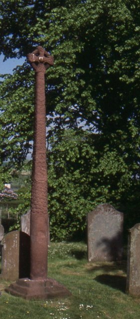
The Gosforth Cross
- Overview About the Gosforth Cross Map Street View The Gosforth Cross is a 10th century high cross standing in the churchyard of St Mary's Church in Gosforth, Cumbria. The carvings …
Co-Curate Page
Grey Croft Stone Circle, near Seascale
- Overview About Grey Croft Stone Circle Map Aerial View Grey Croft Stone Circle (aka Greycroft) is located about half a mile north of the village of Seascale. It was originally …
Co-Curate Page
Burrow Walls Roman Fort
- Overview Map Burrow Walls is located between Workington and Seaton in Cumbria. This Scheduled Monument includes the buried remains of a Roman fort and also visible sections of a wall made …
Co-Curate Page
Triermain Castle (remains)
- Overview Map Street View The remains of a medieval enclosure castle are situated immediately to the east of Triermain Farm and stand on a small glacial mound. The castle was …
Co-Curate Page
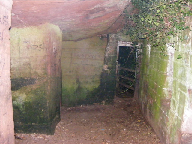
St Constantine's Cells (Wetheral Caves) and rock-cut Roman Graffiti
- Overview Map St Constantine's Cells (aka Wetheral Caves, Wetheral Safeguard, or Constantine's Hermitage) are three chambers cut into the cliff face about 40ft above the River Eden, south of Wetheral. …
Co-Curate Page
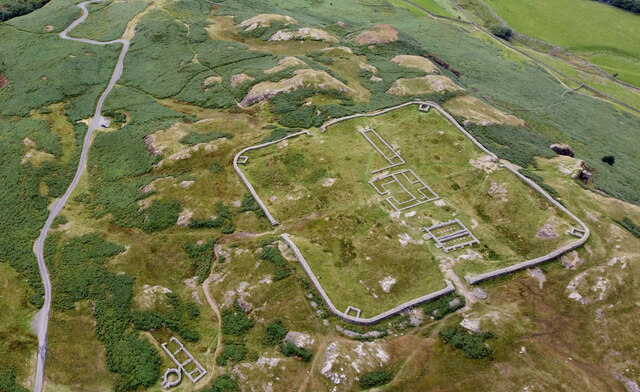
Hardknott Roman Fort
- Overview Map Street View Aerial View The well-preserved remains of Hardknott Roman Fort (Mediobogdum) are located about 5 miles east of the village of Eskdale Green in Cumbria. It was …
Co-Curate Page
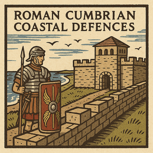
Beckfoot Roman Fort
- The site of Beckfoot Roman Fort (Bibra) is located on the Solway Firth coast, about ½ mile south of the hamlet of Beckford. It formed part of the Roman Cumbrian …

Co-Curate Page
Roman Tile Kilns, near Birks Coppice
- % The site of two Roman tile kilns is located by Birks Coppice in Eskdale, just over 2 miles north-east of Muncaster. The remains of the kilns were first found …
Co-Curate Page
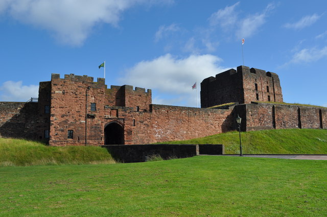
Carlisle Castle
- Overview About Carlisle Castle Map Street View Carlisle Castle is built on the site of a Roman fort (known as Luguvalium). Construction of a motte and bailey castle began in …
Co-Curate Page
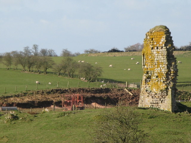
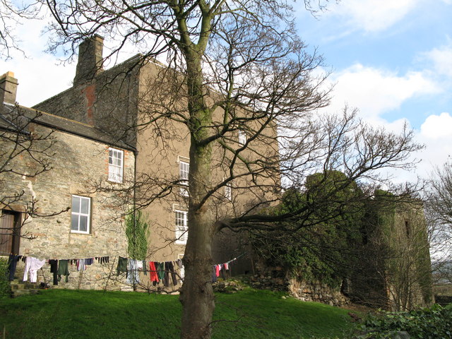
Millom Castle
- Overview About Millom Castle Map Street View About half a mile north of Millom town centre are the ruins of Millom Castle. The site was a moated manor house and …

Co-Curate Page
Priory Gatehouse, Wetheral
- Overview Map Street View The Gatehouse Tower for the former Benedictine Priory at Wetheral dates from the 15th century. The priory was founded in c.1100, but the gatehouse is thought …

Co-Curate Page
Down Hall moated site, Aikton
- Note: Map data from Historic England c/o Open Data UK, under the Open Government Licence, imported into Google MyMaps, March 2026. There is a Medieval moated site, located at Down …
Co-Curate Page
Moated site near Cockbridge
- Scheduled Monument area - map data from Historic England c/o Open Data UK, under the Open Government Licence, imported into Google MyMaps, March 2026. Scheduled Monument (# 1007133 ): Moated …
Co-Curate Page
Four medieval shielings on south bank of White Lyne overlooking confluence with Little Hare Grain
- This group of four Medieval shielings is in a remote area about 3½ miles north of Bewcastle. The remains are situated by the White Lyne in an area which is …
Co-Curate Page
Ten medieval shielings on north bank of White Lyne overlooking confluence with Little Hare Grain
- Scheduled Monument (#1016404): Ten medieval shielings on north bank of White Lyne overlooking confluence with Little Hare Grain Click the headings below to expand (selected extracts from the Historic England …

Co-Curate Page
Bastle at Upper Denton
- There is roofless bastle standing two storeys high located at the northern end of the village of Upper Denton. It is constructed of squared coursed rubble with red sandstone dressings. …
Co-Curate Page
Castlerigg Stone Circle
- Overview About Castlerigg Stone Circle Map Street View Castlerigg Stone Circle, located just over a mile east of Keswick, is one of the earliest stone circles in the UK, thought …
Co-Curate Page
Swinside Stone Circle
- Overview About Swinside Stone Circle Map Street View Swinside Stone Circle (also known as Sunkenkirk Stone Circle) is a stone circle from either the Neolithic or Bronze Age date, located …
Co-Curate Page
Hodbarrow Old Lighthouse
- The old lighthouse (aka Hodbarrow Beacon) is located 380m north-west of Hodbarrow Point, to the south of Millom. Built in the 19th Century, it is one of the last surviving …
Co-Curate Page
Birdoswald Roman Fort (Banna)
- Overview Map Street View Hadrian's Wall Glossary Birdoswald Roman Fort (known as Banna) is situated on the western part of Hadrian's Wall, about 1 mile west of Gilsland in Cumbria. …
Co-Curate Page
Scots Dyke
- Scots Dyke (aka Scots' Dike) is a 3½ mile long earthwork, constructed by the English and the Scots in 1552 to mark the division of the 'Debatable Lands' which had …
Co-Curate Page
Medieval Bewcastle Cross
- The high cross shaft in the churchyard of St Cuthbert's Church in Bewcastle dates from the 7th century. The Bewcastle Cross is a scheduled monument. The Stone Cross at St …
Co-Curate Page
The Gosforth Cross
- Overview About the Gosforth Cross Map Street View The Gosforth Cross is a 10th century high cross standing in the churchyard of St Mary's Church in Gosforth, Cumbria. The carvings …
Co-Curate Page
Grey Croft Stone Circle, near Seascale
- Overview About Grey Croft Stone Circle Map Aerial View Grey Croft Stone Circle (aka Greycroft) is located about half a mile north of the village of Seascale. It was originally …
Co-Curate Page
Burrow Walls Roman Fort
- Overview Map Burrow Walls is located between Workington and Seaton in Cumbria. This Scheduled Monument includes the buried remains of a Roman fort and also visible sections of a wall made …
Co-Curate Page
Triermain Castle (remains)
- Overview Map Street View The remains of a medieval enclosure castle are situated immediately to the east of Triermain Farm and stand on a small glacial mound. The castle was …
Co-Curate Page
St Constantine's Cells (Wetheral Caves) and rock-cut Roman Graffiti
- Overview Map St Constantine's Cells (aka Wetheral Caves, Wetheral Safeguard, or Constantine's Hermitage) are three chambers cut into the cliff face about 40ft above the River Eden, south of Wetheral. …
Co-Curate Page
Hardknott Roman Fort
- Overview Map Street View Aerial View The well-preserved remains of Hardknott Roman Fort (Mediobogdum) are located about 5 miles east of the village of Eskdale Green in Cumbria. It was …
Co-Curate Page
Beckfoot Roman Fort
- The site of Beckfoot Roman Fort (Bibra) is located on the Solway Firth coast, about ½ mile south of the hamlet of Beckford. It formed part of the Roman Cumbrian …
Co-Curate Page
Roman Tile Kilns, near Birks Coppice
- % The site of two Roman tile kilns is located by Birks Coppice in Eskdale, just over 2 miles north-east of Muncaster. The remains of the kilns were first found …
Co-Curate Page
Carlisle Castle
- Overview About Carlisle Castle Map Street View Carlisle Castle is built on the site of a Roman fort (known as Luguvalium). Construction of a motte and bailey castle began in …
Co-Curate Page
Millom Castle
- Overview About Millom Castle Map Street View About half a mile north of Millom town centre are the ruins of Millom Castle. The site was a moated manor house and …
Co-Curate Page
Priory Gatehouse, Wetheral
- Overview Map Street View The Gatehouse Tower for the former Benedictine Priory at Wetheral dates from the 15th century. The priory was founded in c.1100, but the gatehouse is thought …
Co-Curate Page
Down Hall moated site, Aikton
- Note: Map data from Historic England c/o Open Data UK, under the Open Government Licence, imported into Google MyMaps, March 2026. There is a Medieval moated site, located at Down …
Co-Curate Page
Moated site near Cockbridge
- Scheduled Monument area - map data from Historic England c/o Open Data UK, under the Open Government Licence, imported into Google MyMaps, March 2026. Scheduled Monument (# 1007133 ): Moated …
Co-Curate Page
Four medieval shielings on south bank of White Lyne overlooking confluence with Little Hare Grain
- This group of four Medieval shielings is in a remote area about 3½ miles north of Bewcastle. The remains are situated by the White Lyne in an area which is …


