Topics > Tyne and Wear > Newcastle upon Tyne > Newburn > Newburn Then and Now
Newburn Then and Now
 Extract from OS 6 inch map 1888-1913. (CC-BY NLS)
The map above shows Newburn around the turn of the 19th century.
Select 'Now' and 'Then' (above) to switch between the old map and the modern aerial view.
 Newburn - modern aerial view (CC-BY NLS)
Old maps can give us great insights into our history. Some observations:
Newburn Steel Works
The map shows how the east side of Newburn used to be dominated by Spencer's steel works. John Spencer and Sons Ltd. established works at Newburn in 1822, initially based in an old water mill in Walbottle Dene. However, the business grew significantly after further land was purchased in 1830. A section of the New Burn (river) was culverted in the 1850's to allow further growth of the site. By 1900, Spencer's works had expanded to cover 60 acres and employed around 1,800 people.[1] The works specialised in making springs for the railway industry, and later produced steel plate, including that used for the ocean liner Mauretania, which was launched in 1906.
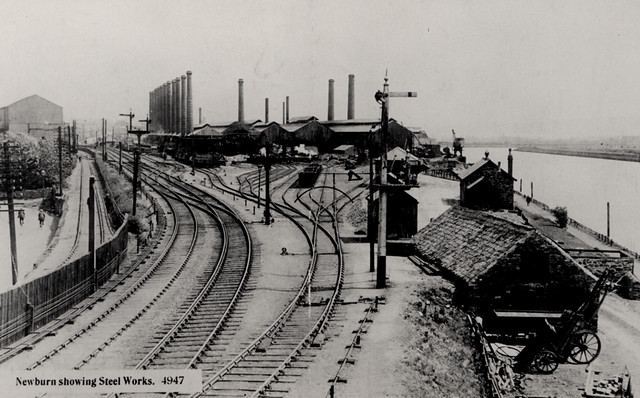
Spencer's Steel Works, c.1920. c/o Newcastle Libraries
The works closed between 1924 and 1926 during the Great Depression, and the main plant and its chimneys were largely demolished by 1933. However, the company did revive after the depression and continued smaller operations until it's final closure in the 1960s.
The footprint of the steel works is evident in today's Newburn (see aerial view). The area is semi-industrial, with several businesses located on the site. A few of the 19th century buildings, including the Rolling Mill, survive and are now used for other purposes. Newburn Industrial Estate has been established by the riverside.
Railway

Newburn Station - West Newcastle Picture History Collection, CC-BY-ND
The map clearly dates from the 'Age of the Railway'. In addition to the main line through Newburn, the map shows extensive railway sidings linked with the Steel Works, North Walbottle Colliery, Newburn Hill sand and gravel quarry, and Newburn Waterworks. The main station in Newburn was opened in 1875. It was on the North Wylam Loop, including trains to Newcastle. The advent of trams, buses and then wider ownership of cars saw use of the trains rapidly decline during the 20th century. The station was closed to passengers in 1958, and to freight in 1965. The station buildings were demolished, but the tracks weren't removed until 1986. Station Road in today's Newburn gives a clue as to where the station was once located! Much of the trackbed of the North Wylam Loop now forms a cycle and walking route.
Newburn Bridge
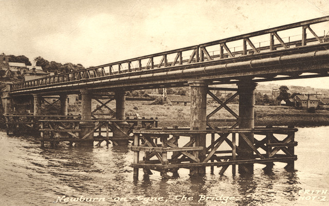
Newburn Bridge c.1920. c/o Newcastle Libraries
It's still the same bridge today - though having needed a number of structural repairs in recent years! The big difference is that the old map shows it as a toll bridge and also shows the Toll House by the bridge. Newburn Bridge over the River Tyne was opened on the 21st of May 1893. It only became free to use after it was purchased by Northumberland County Council in 1947. The bridge had two road lanes up until the 1960s, when the road was narrowed to a single lane to limit weight on the structure. The Toll House no longer exists.
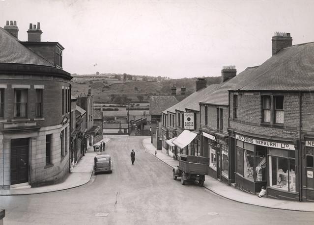
High Street
Newburn High Street,1909. c/o Newcastle Libraries
The High Street looks very different today! Though, the Almshouses shown on the map and in the photo are still there now.
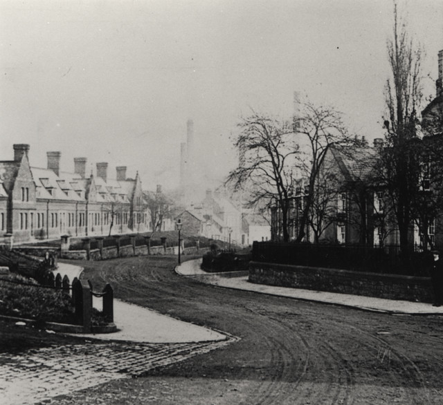
School
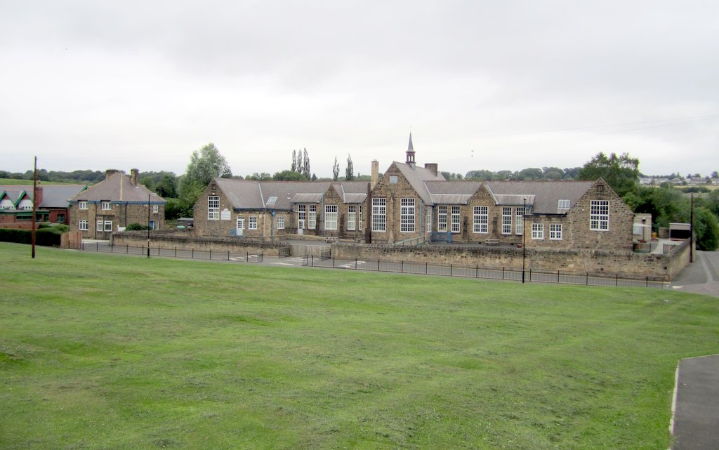
Photo by Andrew Curtis, CC-BY-SA.
The school is still there! The old map shows the school to the north of Newburn on Millfield Lane. It is now Newburn Manor Primary School. The building dates from c.1890, though an earlier school of 1822 is documented in Newburn.
Church and Chapel
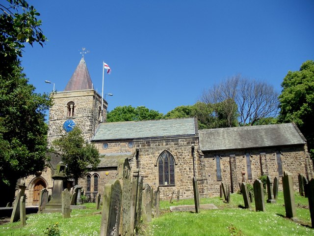
Photo by Bill Henderson, 2012, CC-BY-SA
Unsuprisingly, the map shows the Church of St Michael and All Angels - which has been a constant in Newburn since the 11th century!
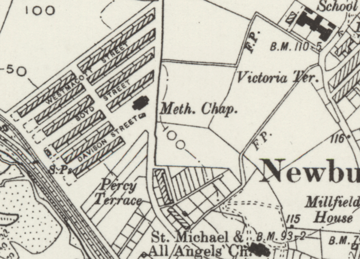
Extract from OS 6 inch map 1888-1913. (CC-BY NLS)
The map also shows a Methodist Chapel on Davison Street, by the terraces on the west side of Newburn. This was originally a Wesleyan Chapel, built in 1898. It was extended, adding a Sunday School in 1905. The chapel closed in 1965 and for a time, the building served as the Tropic Tan Solarium.[2] It was demolished in c.1980, when new housing was built here, but remembered in the new street name: Chapel Court. The layout of the other terraces of houses (Westmacott Street, Boyd Street and Davison Street) near the chapel, look more-or-less the same today.
Newburn Hill Sand Pit
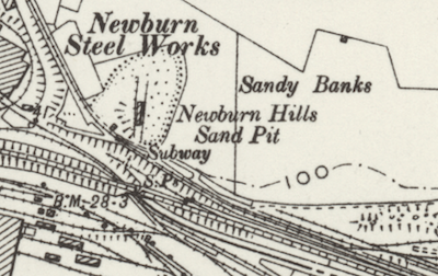
Extract from OS 6 inch map 1888-1913. (CC-BY NLS)
Newburn Hill Sand Pit was located by Sandy Banks to the east of Newburn. It was not a playground for the children of Victorian Newburn!!! Rather, it was a large-scale site for extracting sand and gravel for building and industrial purposes. Today, the site is used by Sandhills Composing Centre (garden waste recycling), run by Newcastle City Council.

from http://twsitelines.info/SMR/4…
Tyne and Wear HER(4231): Newburn, Spencer's Steel Works
- "The firm of John Spencer and Sons Ltd. was founded in the year 1810 by John Spencer who had been an apprentice in the Sheffield Steel Works, and afterwards was …
Added by
Simon Cotterill

Co-Curate Page
Spencer's Steelworks, Newburn (1822-1960's)
- John Spencer and Sons Ltd. established works at Newburn in 1822, initially based in an old water mill in Walbottle Dene. However, the business grew significantly after further land was …
from https://sitelines.newcastle.g…
Newburn Road, Methodist Church
- Wesleyan Chapel built 1898. Extended in 1905 with Sunday School to rear. Gable front. Closed 1965 and ended its days as the Tropic Tan Solarium. Demolished circa 1980. Modern house …
Added by
Simon Cotterill

from http://twsitelines.info/SMR/4…
Tyne and Wear HER(4231): Newburn, Spencer's Steel Works
- "The firm of John Spencer and Sons Ltd. was founded in the year 1810 by John Spencer who had been an apprentice in the Sheffield Steel Works, and afterwards was …
Added by
Simon Cotterill
Co-Curate Page
Spencer's Steelworks, Newburn (1822-1960's)
- John Spencer and Sons Ltd. established works at Newburn in 1822, initially based in an old water mill in Walbottle Dene. However, the business grew significantly after further land was …
from https://sitelines.newcastle.g…
Newburn Road, Methodist Church
- Wesleyan Chapel built 1898. Extended in 1905 with Sunday School to rear. Gable front. Closed 1965 and ended its days as the Tropic Tan Solarium. Demolished circa 1980. Modern house …
Added by
Simon Cotterill