Topics > Northumberland > Civil Parishes in Northumberland > Plenmeller with Whitfield Civil Parish > Historic Buildings and Monuments in Plenmeller with Whitfield
Historic Buildings and Monuments in Plenmeller with Whitfield
Listed buildings and scheduled monuments in Plenmeller with Whitfield Civil Parish, from the National Heritage List for England. In the absence of a published 'local list', some other public buildings of interest may also be included. Use the Search (below) if looking for a specific building / monument.
| Structure | List No. | Grade | Built~ | Locality | Note |
|---|---|---|---|---|---|
| Bath House 120 Metres North West of Whitfield Hall | 1156066 | II | 1930 | Whitfield | |
| Bear's Bridge over the Dewsgreen Burn | 1045426 | II | 1759 | Bearsbridge | |
| Blackett Bridge over the River West Allen | 1045440 | II | 1857 | ||
| Blacksmith's Shop and Adjoining House | 1370238 | II | c19th | ||
| Blueback Bridge over River West Allen | 1045432 | II | c18th | ||
| Boundary Stone on North Side of Road 40 Metres East of Junction | 1045427 | II | 1800 | ||
| Burnmouth Bridge, over Church Burn | 1045423 | II | 1759 | Burnmouth | A686 |
| Byre and Stable Ranges to North of West Plenmeller Farmhouse | 1155903 | II | c19th | ||
| Camp in Oakwood SE of Plenmeller village | 1006484 | n/a | nr. Plenmeller | Scheduled Monument | |
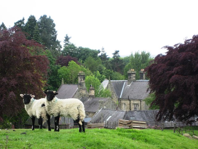
| Church of St John | 1045438 | II | c.1790 | Whitfield | |
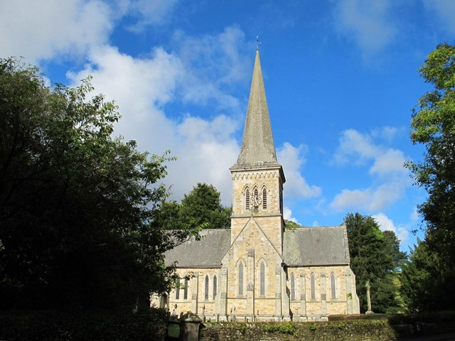
| Church of the Holy Trinity | 1156049 | II* | 1860 | nr. Whitfield | |
| Coach House and Adjacent Buildings at Whitfield Hall | 1045434 | II | 1786 | Whitfield | |
| Cupola Bridge, over the River West Allen | 1370236 | II | 1778 | Bearsbridge | |
| East Unthank Farmhouse, Cottage and Adjoining Outbuilding | 1155927 | II | 1840 | East Unthank | |
| Farmbuildings Adjoining Morley Hill Farmhouse to North-East | 1370237 | II | c19th | ||
| Garden Wall West of Whitfield Hall | 1156095 | II | c18th | Whitfield | |
| Garden Wall West of Whitfield Hall Tennis Courts | 1045435 | II | c18th | Whitfield | |
| Gate Piers, Gate and Garden Wall to West of Unthank Hall | 1370241 | II | c19th | Unthank | |
| Kitchen Wing, Walls and Outbuilding 30 Metres South of Unthank Hall | 1303093 | II | 1860 | Unthank | by John Dobson |
| Limekiln 120 Metres West of Ouston House | 1155879 | II | c19th | Ouston | |
| Limekiln on East Bank of Slatequarry Cleugh | 1045421 | II | c19th | Nr. Whitfield | |
| Morley Hill Farmhouse | 1045424 | II | 1860 | ||
| Noah's Ford - Bridge over Church Burn | 1045422 | II | c18th | ||
| Old Dyke Row Farmhouse | 1045439 | II | c18th | ||
| Old Town Farmhouse | 1370235 | II | 1790 | ||
| Ouston House | 1303158 | II | c18th | Ouston | |
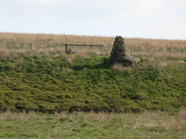
| Plenmeller War Memorial Cairn | 1439867 | II | c20th | Plenmeller | Also known as 'The Currick' |
| Settling Tank and Drain Outlet 120 Metres North West of Unthank Hall | 1045431 | II | c18th | Unthank | |
| Statue of Apenthe to North of Whitfield Hall Tennis Courts | 1045436 | II | 1893 | Whitfield | |
| Statue of Caprice 20 Metres East of Bath House, Whitfield Hall | 1045437 | II | 1891 | Whitfield | |
| Statue of Thorsulus 40 Metres South West of Whitfield Hall | 1303024 | II | 1892 | Whitfield | |
| Sundial 16 Metres South of South West Corner of Church of St John | 1302985 | II | 1756 | Whitfield | |
| Terrace Walls, Balustrades and Steps to North of Unthank Hall | 1303046 | II | c19th | Unthank | |
| The Lion's Mouth - Spring 100 Metres East of Whitfield Hall | 1156125 | II | c18th | Whitfield | |
| The Old Post Office and Adjacent Outbuildings | 1155837 | II | c19th | ||
| The Old Rectory | 1156228 | II | 1762 | Whitfield | |
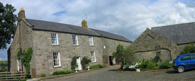
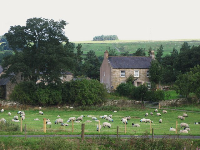
| Unthank Hall | 1155943 | II | 1815 | Unthank | c16th, extended 1815 by John Dobson |
| Wall, Railings and Gate on East Side of Garden at Ouston House | 1370239 | II | c19th | Ouston | |
| West Lodge | 1045430 | II | 1861 | ||
| West Plenmeller Farmhouse and Adjacent Barn | 1045429 | II | c16th | Plenmeller | |
| West Unthank Farmhouse | 1370242 | II | c19th | West Unthank | |
| Western Farmhouse at Shankfoot | 1370240 | II | c17th | Shankfoot | |
| Whitewalls | 1045428 | II | c18th | ||
| Whitfield Hall | 1045433 | II | 1785 | Whitfield | |
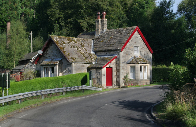
| Whitfield Old Toll House | 1045425 | II | 1832 | Whitfield | |
| Whitfield War Memorial | 1442956 | II | c20th | Whitfield | |
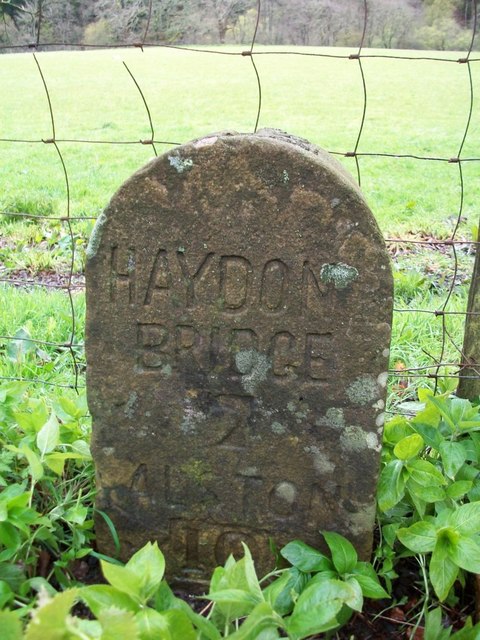
| Milestone north-east of Bearsbridge | not listed | n/a | C18th | Bearsbridge | A686 |
Primary source: the National Heritage List for England - NHLE is the register of nationally protected historic buildings and sites in England, including listed buildings, scheduled monuments, protected wrecks, registered parks and gardens, and battlefields. The list is maintained by Historic England. Check NHLE for updates and new entries. Secondary sources: British Listed Buildings.
Co-Curate Page
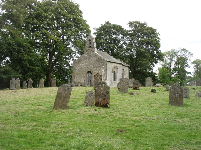
Church of St John
- Overview Map Street View Church in Whitfield, Northumberland, built c.1790. This was the parish church for Whitfield, until the Church of the Holy Trinity was built in 1860.
Co-Curate Page
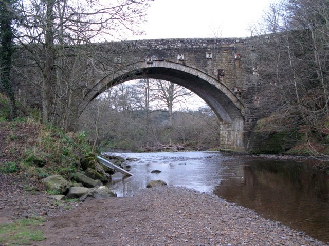
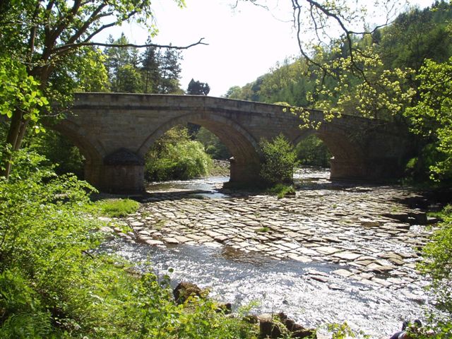
Cupola Bridge
- Overview Map Street View Cupola Bridge is a three arch stone bridge which carries the A686 road over the River Allen, built 1778 and located 1½ miles from Whitfield, Northumberland. …
Co-Curate Page
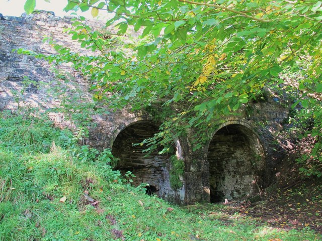
Lime Kiln, west of Whitfield
- There is a well preserved 19th century lime kiln to the west of Whitfield in Northumberland. It is in an isolated location below Dykerow Fell and on the east bank of …
Co-Curate Page
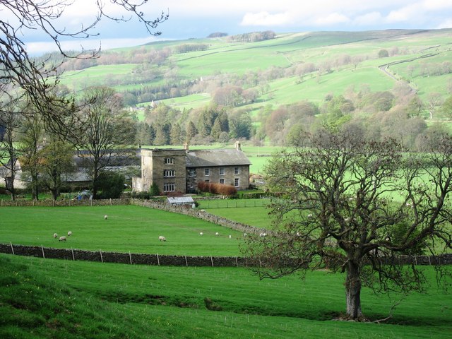
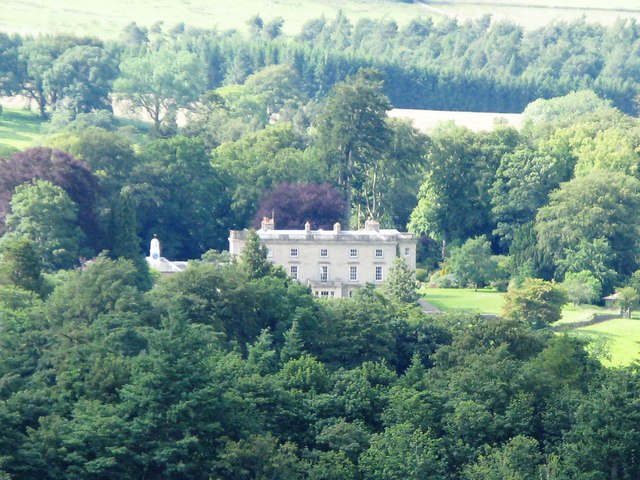
Unthank Hall, nr Plenmeller
- Overview Map Street View Unthank is located on the south banks of the River South Tyne, south-west of Haltwhistle. Unthank is the site of a deserted medieval village[1] and the …
Co-Curate Page
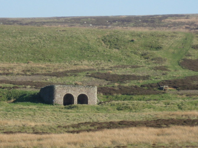
War memorial cairn on Plenmeller Common
- Overview Map A war memorial cairn is located on Plenmeller Common, about 2½ miles south-east of Haltwistle. Also known as 'The Currick', the cairn was built by sheperds before 1939 …
Co-Curate Page
Old Toll House, Whitfield
- This former toll house is located on the West side of the A686 in Whitfield. It is a Grade II listed building on the National Heritage List for England.
Co-Curate Page
East Unthank
- Overview Map East Unthank is a farm, situated near the south banks of the River South Tyne. It is located on Unthank Road, about ½ mile east of Unthank Hall …
Co-Curate Page
West Unthank
- Overview Map West Unthank is a farm, situated on the south banks of the River South Tyne. It is located off Unthank Road, about ½ mile north-west of Unthank Hall, …
Co-Curate Page
Old Milestone, north of Bearsbridge
- There is an old milestone on the south side of the A686 road, near Tarry Back, about half mile north-east of Bearsbridge. It was erected by the Alston Turnpike Trust …

Co-Curate Page
Church of St John
- Overview Map Street View Church in Whitfield, Northumberland, built c.1790. This was the parish church for Whitfield, until the Church of the Holy Trinity was built in 1860.
Co-Curate Page
Cupola Bridge
- Overview Map Street View Cupola Bridge is a three arch stone bridge which carries the A686 road over the River Allen, built 1778 and located 1½ miles from Whitfield, Northumberland. …
Co-Curate Page
Lime Kiln, west of Whitfield
- There is a well preserved 19th century lime kiln to the west of Whitfield in Northumberland. It is in an isolated location below Dykerow Fell and on the east bank of …
Co-Curate Page
Unthank Hall, nr Plenmeller
- Overview Map Street View Unthank is located on the south banks of the River South Tyne, south-west of Haltwhistle. Unthank is the site of a deserted medieval village[1] and the …
Co-Curate Page
War memorial cairn on Plenmeller Common
- Overview Map A war memorial cairn is located on Plenmeller Common, about 2½ miles south-east of Haltwistle. Also known as 'The Currick', the cairn was built by sheperds before 1939 …
Co-Curate Page
Old Toll House, Whitfield
- This former toll house is located on the West side of the A686 in Whitfield. It is a Grade II listed building on the National Heritage List for England.
Co-Curate Page
East Unthank
- Overview Map East Unthank is a farm, situated near the south banks of the River South Tyne. It is located on Unthank Road, about ½ mile east of Unthank Hall …
Co-Curate Page
West Unthank
- Overview Map West Unthank is a farm, situated on the south banks of the River South Tyne. It is located off Unthank Road, about ½ mile north-west of Unthank Hall, …


