Topics > Northumberland > Civil Parishes in Northumberland > Hedgeley Civil Parish > Historic Buildings and Monuments in Hedgeley Civil Parish
Historic Buildings and Monuments in Hedgeley Civil Parish
Listed buildings and scheduled monuments in Hedgeley Civil Parish, Northumberland, from the National Heritage List for England[1]. Use the Search (below) if looking for a specific building / monument.
| Structure | List No. | Grade | Built~ | Notes |
|---|---|---|---|---|
| Archway and Gates Stable Block and Attached Wall to North East of Shawdon Hall | 1374397 | II | ||
| Attached Garden Wall to North East of Bolton Hall | 1366616 | II | ||
| Bolton Chapel | 1055775 | II | C12th | Major restoration in C19th |
| Bolton Hall | 1055758 | II | C17th | Bolton |
| Bolton Mill House | 1371094 | II | C19th | |
| Bridge over River Aln 470 Metres North West of West Brizlee | 1371086 | II | ||
| Coach House and Stables North of Greenfield Cottage | 1374221 | II | ||
| Crawley Tower with Cottage Inside | 1057698 | II* | C14th | Near Powburn. Pele tower. |
| Dean House Farmhouse | 1371091 | II | ||
| Dovecote and Adjacent Outbuilding East of Dean House Farmhouse | 1055765 | II | ||
| Dovecote and Attached Yard Walls to North of Titlington Mount Farmhouse | 1371098 | II | Titlington Mount | |
| Dovecote Henhouse and Attached Shelter Shed on South Side of Road | 1041959 | II | C19th | East Bolton |
| East Lodge and gate screen (Shawdon Hall) | 1041967 | II | ||
| Field House | 1374218 | II | ||
| Garden Wall to North West of Hedgeley Hall | 1371095 | II | ||
| Garden Wall to South West of Bolton Hall | 1371093 | II | ||
| Garden Walls with Attached Outbuildings 200 Metres South East of Shawdon Hall | 1038332 | II | ||
| Gate Piers and Screen Walls to East of Bolton Hall | 1041958 | II | ||
| Gate Screen to Titlington Hall | 1031913 | II | ||
| Greenfield Cottage | 1041963 | II | ||
| Guide Post East of Road Junction North East of Bolton Village | 1057692 | II | ||
| Guide Post on West Side of Road Junction 400 Metres North of Hedgeley Hall | 1039115 | II | ||
| Ha Ha Wall to South of Shawdon Hall | 1041966 | II | ||
| Hall Headstone 7 Metres South of the Chancel of Bolton Chapel | 1041956 | II | ||
| Hedgeley Hall with Screen Wall to South West | 1057652 | II | ||
| Hedgely West Cottages and Linking Walls | 1041954 | II | ||
| Jennys Lantern on Hilltop 1.4 Kilometres South West of East Bolton Farm | 1041960 | II | C18th | |
| Laundry Cottage on West of Stableyard North of Shawdon Hall | 1041965 | II | ||
| Low Hedgeley Farmhouse | 1041961 | II | ||
| Main Group of Farmbuildings to North East of Low Hedgeley Farmhouse | 1039108 | II | ||
| Milepost 370 Metres North of Junction with Road to Glanton | 1041953 | II | ||
| Milepost 520 Metres South of Percy Cross | 1371090 | II | ||
| Old Smithy to East of Main Farmbuilding Group | 1041962 | II | ||
| Outbuilding to West of Bolton Hall | 1041957 | II | ||
| Percys Cross with Enclosing Wall and Railings | 1041952 | II* | C15th | After Battle of Hedgeley Moor, 1464 |
| Plough Inn with Outbuilding to North | 1041964 | II | C18th | Powburn. Closed |
| Ruins of Screen Wall and End Pavilions to South of Hermitage | 1041968 | II | ||
| Screen Wall and Gate Piers at West Entrance to Shawdon Hall | 1038314 | II | ||
| Shawdon Hall | 1038949 | II* | 1779 | Shawdon |
| Shelter Sheds to North East of Main Farmbuilding Group | 1371096 | II | ||
| Shelter Sheds to North of Titlington Mount Farmhouse | 1041929 | II | Titlington Mount | |
| Stable Range to East of Dean House Farmhouse | 1041955 | II | ||
| Stable Range to North East of Titlington Hall | 1041969 | II | ||
| Titlington Hall | 1038290 | II | 1824 | Titlington |
| West Lodge at Shawdon Hall | 1371097 | II | ||
| Percy's Cross, Beanley | 1006578 | n/a | C15th | Scheduled Monument |
| Romano-British enclosed settlement on Beanley Moor, 800m south-east of Broomhouse | 1011548 | n/a | Scheduled Monument | |
| Round cairn, 50m south of Titlington Pike | 1011549 | n/a | Scheduled Monument | |
| Defended settlement on Beanley Moor 780m east of Beanley South Side Farm | 1011550 | n/a | Scheduled Monument | |
| The Ringses camp, group of burial mounds and two cairns, Beanley Moor | 1006594 | n/a | Bronze age | Scheduled Monument |
| Earthwork at Crawley Tower | 1006599 | n/a | Scheduled Monument | |
| Defended settlement, 750m east of Titlington Hall Farm | 1007445 | n/a | Scheduled Monument | |
| Romano-British enclosed settlement, 800m NW of East Bolton | 1007446 | n/a | Scheduled Monument | |
| Defended settlement, 400m west of Titlington Mount | 1007447 | n/a | Scheduled Monument | |
| Round cairn, 190m south-east of Titlington Pike | 1007448 | n/a | Scheduled Monument | |
| Round cairn, 78m south-east of Titlington Pike | 1007449 | n/a | Scheduled Monument | |
| Round cairn on Titlington Pike | 1007450 | n/a | Scheduled Monument | |
| Medieval farmstead, 500m ENE of Titlington Mount | 1007451 | n/a | Scheduled Monument | |
| Romano-British farmstead on Beanley Moor, 500m SSE of Broom House | 1007452 | n/a | Scheduled Monument | |
| Multivallate defended settlement, 350m north-east of Wood House | 1007453 | n/a | Scheduled Monument | |
| Romano-British enclosed settlement and hut-circles on Beanley Moor, 650m south-east of Broomhouse | 1007454 | n/a | Scheduled Monument | |
| Cup and ring marked rock, 1km south-west of East Bolton | 1007519 | n/a | Scheduled Monument | |
| Romano-British farmstead 1km south-west of East Bolton | 1007520 | n/a | Scheduled Monument | |
| Bolton leper hospital | 1008838 | n/a | C13th | Scheduled Monument |
| Defended settlement, Romano-British settlement and field system 100m south and east of Jenny's Lantern | 1008839 | n/a | Scheduled Monument | |
| Ancient settlement Hunterheugh Crags | 1006476 | n/a | Scheduled Monument | |
| Alnwick Castle - grounds (listing includes Hulne Park) | 1001041 | I | C19th | Listed Park and Garden. Hulne Park is partly in this parish |
Primary source: the National Heritage List for England - NHLE is the register of nationally protected historic buildings and sites in England, including listed buildings, scheduled monuments, protected wrecks, registered parks and gardens, and battlefields. The list is maintained by Historic England. Check NHLE for updates and new entries.
Secondary sources: British Listed Buildings and Keys to the Past.
Co-Curate Page
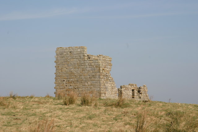
Crawley Tower, near Powburn
- Crawley Tower was built early in the 14th century with a licence to crenelate being granted in 1343.
Co-Curate Page
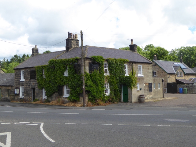
The Plough Inn, Powburn
- The Plough Inn pub and restaurant in Powburn closed in 2015. The Plough dates from the 18th Century and was originally a coaching inn, located on the road (A697) between Newcastle …
Co-Curate Page
Titlington Hall
- Overview Map Street View Tiltington Hall is a large country house at Titlington, built in 1824 for W.M. Pawson.[1] This replaced an earlier house here which was built in 1745 …
Co-Curate Page
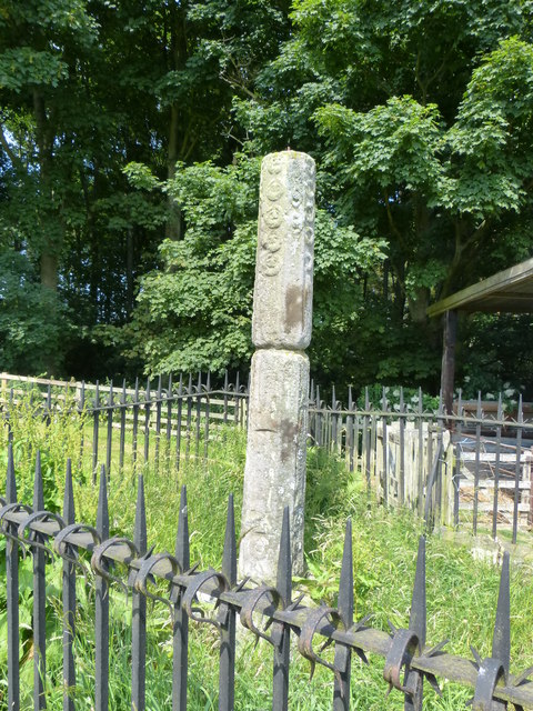
Percy's Cross (between Powburn & Wooperton)
- Overview Map This is a 15th century wayside cross, located close to the A697 road between Powburn and Wooperton in Northumberland. The cross commemorates Sir Ralph Percy who was killed near …
Co-Curate Page
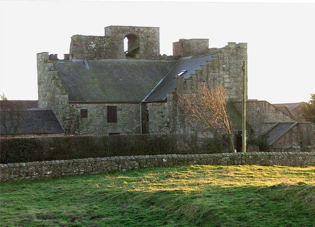
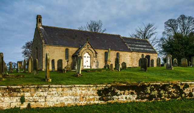
Bolton Chapel, Northumberland
- Overview Map Street View The chapel in Bolton, Northumberland, dates from at least the 12th century. The chapel was extensively restored and extended in c.1868, but retains it's C12th chancel …

Co-Curate Page
Dovecote - henhouse, East Bolton
- There is an unusual combined dovecote and henhouse at East Bolton. The lower part of dovecote has stone wall boxes for hens, the upper part smaller boxes for pigeons. It is …
Co-Curate Page
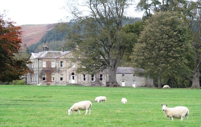
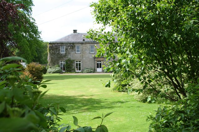
Bolton Hall, Northumberland
- Overview Map Bolton Hall is located in West Bolton in Northumberland. It is a country house, now divided into 2 dwellings. The Hall's north-east range dates from the late 17th …
Co-Curate Page
Bolton Leper Hospital
- Overview Map A leper hopital was established in Bolton, Northumberland, in the 13th century. The site covers a large area to the north of the modern village. There are few …
Co-Curate Page
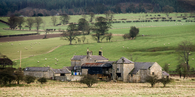
Bolton Mill, Northumberland
- Overview Map Street View Bolton Mill Farm in Northumberland is located by a bend in the River Aln, and is located about 4 miles west of Alnwick and just under …

Co-Curate Page
The Ringses camp, burial mounds and cairns, Beanley Moor
- Scheduled Monument areas - based on Historic England data (Open Government Licence). The Ringses is located on Beanley Moor in Northumberland, about east of Beanley and 1km south-west of Eglingham. …

Co-Curate Page
Crawley Tower, near Powburn
- Crawley Tower was built early in the 14th century with a licence to crenelate being granted in 1343.
Co-Curate Page
The Plough Inn, Powburn
- The Plough Inn pub and restaurant in Powburn closed in 2015. The Plough dates from the 18th Century and was originally a coaching inn, located on the road (A697) between Newcastle …
Co-Curate Page
Titlington Hall
- Overview Map Street View Tiltington Hall is a large country house at Titlington, built in 1824 for W.M. Pawson.[1] This replaced an earlier house here which was built in 1745 …
Co-Curate Page
Percy's Cross (between Powburn & Wooperton)
- Overview Map This is a 15th century wayside cross, located close to the A697 road between Powburn and Wooperton in Northumberland. The cross commemorates Sir Ralph Percy who was killed near …
Co-Curate Page
Bolton Chapel, Northumberland
- Overview Map Street View The chapel in Bolton, Northumberland, dates from at least the 12th century. The chapel was extensively restored and extended in c.1868, but retains it's C12th chancel …
Co-Curate Page
Dovecote - henhouse, East Bolton
- There is an unusual combined dovecote and henhouse at East Bolton. The lower part of dovecote has stone wall boxes for hens, the upper part smaller boxes for pigeons. It is …
Co-Curate Page
Bolton Hall, Northumberland
- Overview Map Bolton Hall is located in West Bolton in Northumberland. It is a country house, now divided into 2 dwellings. The Hall's north-east range dates from the late 17th …
Co-Curate Page
Bolton Leper Hospital
- Overview Map A leper hopital was established in Bolton, Northumberland, in the 13th century. The site covers a large area to the north of the modern village. There are few …
Co-Curate Page
Bolton Mill, Northumberland
- Overview Map Street View Bolton Mill Farm in Northumberland is located by a bend in the River Aln, and is located about 4 miles west of Alnwick and just under …


