Topics > Northumberland > Civil Parishes in Northumberland > Adderstone with Lucker Civil Parish > Historic Buildings and Monuments in Adderstone with Lucker
Historic Buildings and Monuments in Adderstone with Lucker
Listed buildings and scheduled monuments in the Civil Parish of Adderstone with Lucker, Northumberland, from the National Heritage List for England[1]. Use the Search (below) if looking for a specific building / monument.
| Structure | List No. | Grade | Built~ | Note |
|---|---|---|---|---|
| Adderstone Hall | 1370965 | II* | 1819 | Adderstone |
| Bridge over Waren Burn Circa 50 Yards East of Station Cottages | 1206343 | II | 1906 | Lucker |
| Bridge over Waren Burn in Warenford | 1042260 | II | C18th | Warrenford |
| Church of St Hilda | 1042263 | II | C18th | Lucker |
| Garden Wall Attached to Rear of Adderstone Hall | 1206331 | II | 1819 | |
| Garden Walls Gatepiers and Gates to South and South West of the Old Vicarage | 1042265 | II | c.1840 | |
| Gardeners Cottage Circa 300 Yards West of Twizell House | 1206524 | II | C19th | |
| Gatepiers and Screen Wall at Twizell North Lodge | 1042261 | II | C19th | |
| Henhouse and Pigsties Circa 30 Yards North of Hoppen Farmhouse | 1206361 | II | C19th | Hoppen |
| Hoppen Farmhouse | 1370966 | II | C18th | aka Hoppen Hall |
| Limekiln Circa 3/4 Mile West of Adderstone Mains | 1370963 | II | C19th | Adderstone |
| Lucker Mill | 1042264 | II | C18th | Lucker |
| Lucker War Memorial | 1438750 | II | 1920 | Lucker |
| Milepost Circa 100 Yard South East of Twizell North Lodge | 1206309 | II | C19th | |
| Milepost Circa 100 Yards South of Junction with B6348 | 1042259 | II | C19th | |
| Milepost Circa 200 Yards South of Newstead Road End | 1206313 | II | C19th | |
| Paddock Walls and Dovecote Circa 60 Yards North of Lucker Hall | 1206473 | II | C18th | |
| Rayheugh House | 1206325 | II | 1830s | Rayheugh |
| Stable Block Circa 50 Yards North of Adderstone Hall | 1042262 | II | 1819 | |
| The Old Vicarage | 1206484 | II | c.1840 | |
| The Pillars at Junction with B6348 | 1370964 | II | C19th | Bellshill |
| Twizell North Lodge | 1206319 | II | C19th | Twizell House |
| Walled Garden Circa 200 Yards West of Twizell House | 1042266 | II | 1819 | |
| Rosebrough Moor round cairns | 1002911 | n/a | Bronze Age | Scheduled Monument |
| Roundabouts camp | 1003656 | n/a | Iron Age | Scheduled Monument |
| Round cairn cemetery, 820m south west of Stell Plantation | 1006463 | n/a | Bronze Age | Scheduled Monument |
| Isabella's Mount camp | 1006472 | n/a | Iron Age | Scheduled Monument |
| Defended settlement, 1.05 km north west of North Farm | 1006478 | n/a | Iron Age | Scheduled Monument |
| Deserted village of Mousen | 1006452 | n/a | Medieval | Scheduled Monument |
Primary source: the National Heritage List for England - NHLE is the register of nationally protected historic buildings and sites in England, including listed buildings, scheduled monuments, protected wrecks, registered parks and gardens, and battlefields. The list is maintained by Historic England. Check NHLE for updates and new entries. Secondary sources: British Listed Buildings and Keys to the Past.
Co-Curate Page
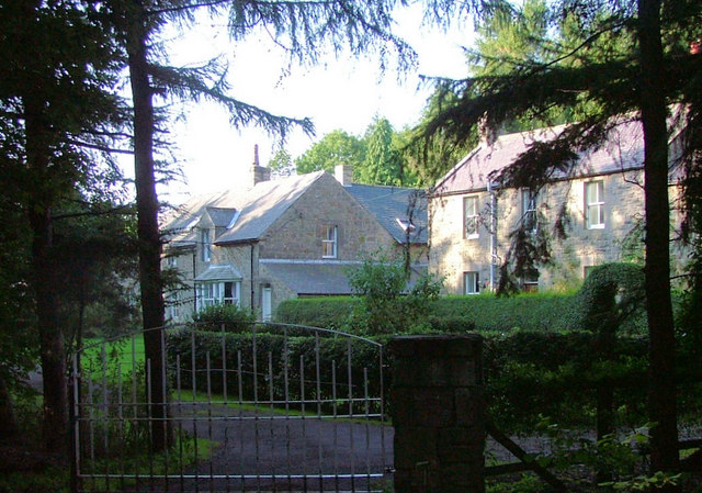
Adderstone Hall
- Overview About Adderstone Hall Map Street View A large Georgian manor house in Adderstone Grange near Lucker in Northumberland. The house, on the site of a much older estate, was built in …
Co-Curate Page
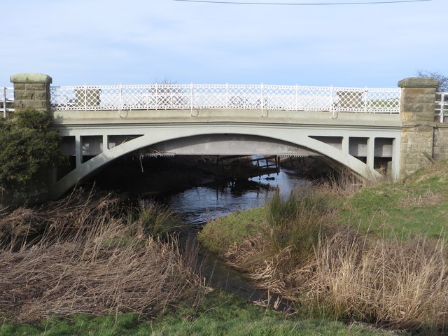
Road Bridge, near Station Cottages
- Overview Map Street View The road bridge over Waren Burn, near Station Cottages, north-west of Lucker, was built in 1906. Built by by Ferro-Concrete Construction, it carries the B1341 road …
Co-Curate Page
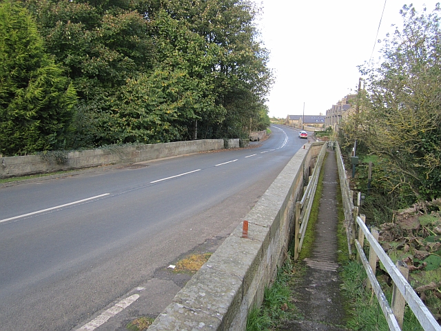
Warenford Bridge
- Overview Map Street View The stone bridge over Waren Burn at Warenford in Northumberland was built in the late 18th or early 19th century and is Grade II listed.[1] The …
Co-Curate Page
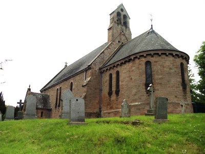
Church of St. Hilda
- Overview Map Street View Saint Hilda's is the parish church in Lucker, Northumberland. It was originally built in the late 18th century, with extensive rebuilding in 1874. The church is …
Co-Curate Page
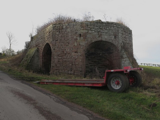
Limekilns, Adderstone Mains
- There are early 19th century Limekilns, located west of Adderstone Mains. Built of sandstone, the limekiln has 3 large arched openings. It is a Grade II listed structure on the …
Co-Curate Page
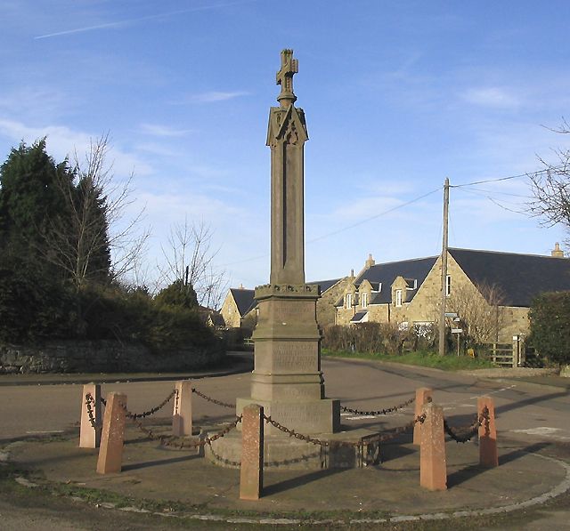
War Memorial
- Overview Map Street View The war memorial in Lucker is located in the centre of village at the junction opposite Church of St. Hilda. The stone cross is 7 ft …
Co-Curate Page
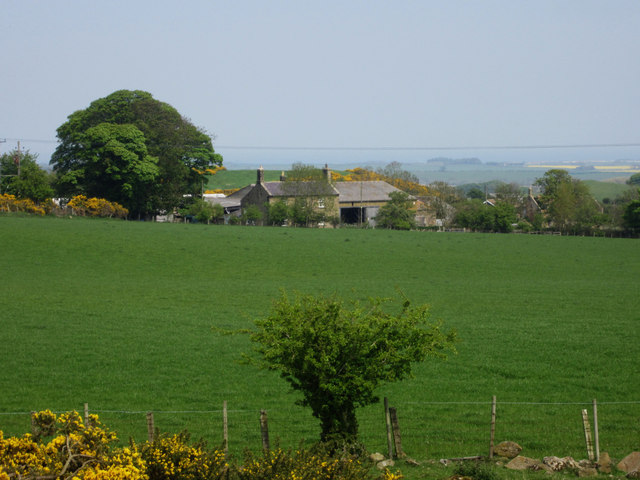
Rayheugh, Northumberland
- Overview Map Street View Rayheugh is a farm / hamlet in Northumberland, located off the A1 road, about 4 miles south-east of Belford and 10 miles north-west of Alnwick. Rayheugh …
Co-Curate Page
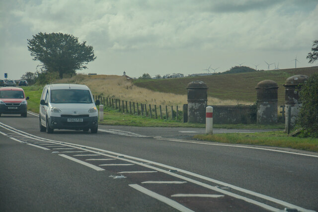
Pillars at junction with B6348
- Overview Map Street View These distinctive gatepiers are located by the B6348 junction with the A1, near Bellshill in Northumberland. They date from the early 19th century and are Grade …

Co-Curate Page
Rosebrough Moor round cairns
- Map showing Rosebrough to the east and the two cairns on Rosebrough to the west. Scheduled Monument (#1002911): Rosebrough Moor round cairns Click the headings below to expand (selected extracts …

Co-Curate Page
Roundabouts camp, east of Bellshill
- Map showing Bellshill, with the Roundabouts camp Scheduled Monument area to the east. About 800m ENE of Bellshill in Northumberland is the site, identified by crop marks, of probable Iron …

Co-Curate Page
Adderstone Hall
- Overview About Adderstone Hall Map Street View A large Georgian manor house in Adderstone Grange near Lucker in Northumberland. The house, on the site of a much older estate, was built in …
Co-Curate Page
Road Bridge, near Station Cottages
- Overview Map Street View The road bridge over Waren Burn, near Station Cottages, north-west of Lucker, was built in 1906. Built by by Ferro-Concrete Construction, it carries the B1341 road …
Co-Curate Page
Warenford Bridge
- Overview Map Street View The stone bridge over Waren Burn at Warenford in Northumberland was built in the late 18th or early 19th century and is Grade II listed.[1] The …
Co-Curate Page
Church of St. Hilda
- Overview Map Street View Saint Hilda's is the parish church in Lucker, Northumberland. It was originally built in the late 18th century, with extensive rebuilding in 1874. The church is …
Co-Curate Page
Limekilns, Adderstone Mains
- There are early 19th century Limekilns, located west of Adderstone Mains. Built of sandstone, the limekiln has 3 large arched openings. It is a Grade II listed structure on the …
Co-Curate Page
War Memorial
- Overview Map Street View The war memorial in Lucker is located in the centre of village at the junction opposite Church of St. Hilda. The stone cross is 7 ft …
Co-Curate Page
Rayheugh, Northumberland
- Overview Map Street View Rayheugh is a farm / hamlet in Northumberland, located off the A1 road, about 4 miles south-east of Belford and 10 miles north-west of Alnwick. Rayheugh …
Co-Curate Page
Pillars at junction with B6348
- Overview Map Street View These distinctive gatepiers are located by the B6348 junction with the A1, near Bellshill in Northumberland. They date from the early 19th century and are Grade …
Co-Curate Page
Rosebrough Moor round cairns
- Map showing Rosebrough to the east and the two cairns on Rosebrough to the west. Scheduled Monument (#1002911): Rosebrough Moor round cairns Click the headings below to expand (selected extracts …


