Topics > Civil Parishes in Cumbria > Greystoke Civil Parish > Greystoke Parish, 1848 > Hutton Soil Township
Hutton Soil Township
Hutton Soil was a township in the ancient parish of Greystoke in Cumberland. The township included the villages of Penruddock and Troutbeck. In 1934, Hutton Soil was combined with Hutton John to form Hutton Civil Parish.[1]
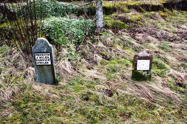
HUTTON-SOIL, a township, in the parish of Greystock, union of Penrith, Leath ward, E. division of Cumberland, 6 miles (W. by S.) from the town of Penrith; containing 359 inhabitants.
Extract from: A Topographical Dictionary of England comprising the several counties, cities, boroughs, corporate and market towns, parishes, and townships..... 7th Edition, by Samuel Lewis, London, 1848.
Co-Curate Page
Penruddock
- Overview About Penruddock Map Street View PENRUDDOCK, a hamlet, in the parish of Greystock, union of Penrith, Leath ward, E. division of Cumberland, 6¼ miles (W. by S.) from Penrith. …

from https://www.cumbriacountyhist…
Hutton Soil
- "Township in Greystoke parish, Leath ward, Cumberland, which included villages of Penruddock and Troutbeck. Combined with Hutton John to form Hutton CP 1934.
Acreage:
4,349 acres [1,760 ha] before acquiring …
Added by
Simon Cotterill

Co-Curate Page
Penruddock
- Overview About Penruddock Map Street View PENRUDDOCK, a hamlet, in the parish of Greystock, union of Penrith, Leath ward, E. division of Cumberland, 6¼ miles (W. by S.) from Penrith. …
from https://www.cumbriacountyhist…
Hutton Soil
- "Township in Greystoke parish, Leath ward, Cumberland, which included villages of Penruddock and Troutbeck. Combined with Hutton John to form Hutton CP 1934.
Acreage:
4,349 acres [1,760 ha] before acquiring …
Added by
Simon Cotterill


