Topics > Civil Parishes in Cumbria > Milnthorpe Civil Parish > Historic Buildings and Monuments in Milnthorpe Civil Parish
Historic Buildings and Monuments in Milnthorpe Civil Parish
Listed buildings and scheduled monuments in Milnthorpe Civil Parish, Cumbria, from the National Heritage List for England[1]. In the absence of a published 'local list', some other public buildings of interest may also be included. Use the Search (below) if looking for a specific building / monument.
Primary source: the National Heritage List for England - NHLE is the register of nationally protected historic buildings and sites in England, including listed buildings, scheduled monuments, protected wrecks, registered parks and gardens, and battlefields. The list is maintained by Historic England. Check NHLE for updates and new entries. Secondary sources: British Listed Buildings.
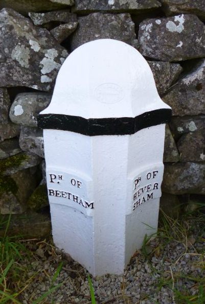
Note: Dalam Tower (building) is in the neighbouring Civil Parish of Beetham.
Co-Curate Page
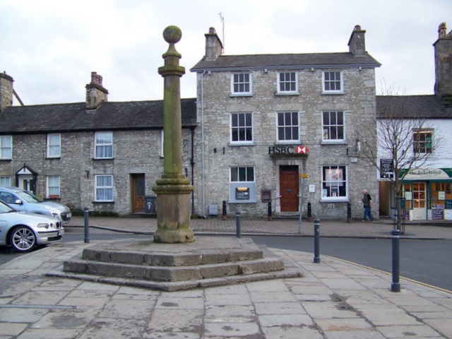
Market Cross, Milnthorpe
- Overview Map Street View The Market Cross in Milnthorpe dates from the 18th century, with the cross repaired or replaced in the early 19th century. In 1845 the cross was …
Co-Curate Page
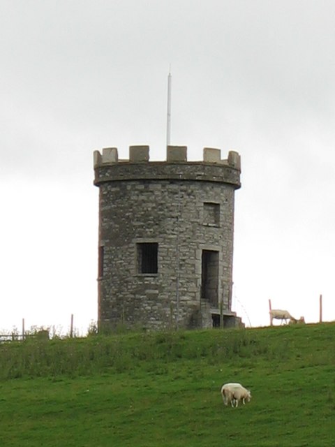
St Anthony's Tower, near Milnthorpe
- Overview Map Street View St Anthony's Tower is a folly / summerhouse, located at the north of Milnthorpe. It is said to have been built to commemorate the Reform Bill …
Co-Curate Page
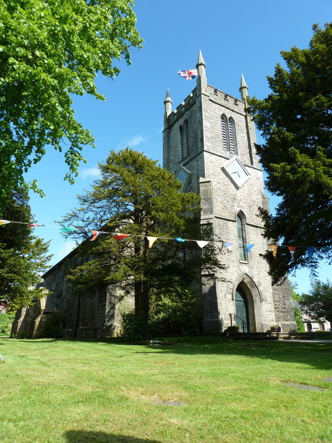
Church of St Thomas, Milnthorpe
- Overview About St Thomas' Church Map Street View St Thomas' Church in Milnthorpe, Cumbria, was built in 1835–1837, designed by George Webster. St Thomas' Church is in the village of …
Co-Curate Page
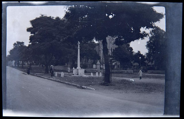
War Memorial, Milnthorpe
- Overview Map Street View The war memorial in Milnthorpe is located on the south side of Main Street, opposite the junction with Police Square, near St Thomas' Church. It was …
Co-Curate Page
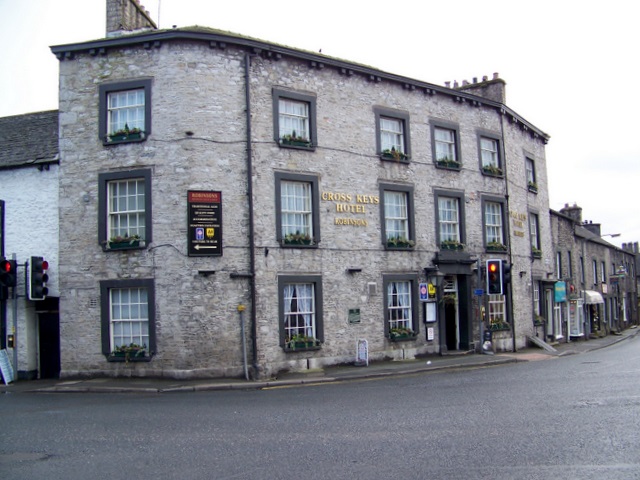
The Cross Keys Hotel, Milnthorpe
- Overview Map Street View The Cross Keys was a hotel and bar on Park Road in Milnthorpe. It closed in October 2022. The building dates from the early 19th century, …
Co-Curate Page
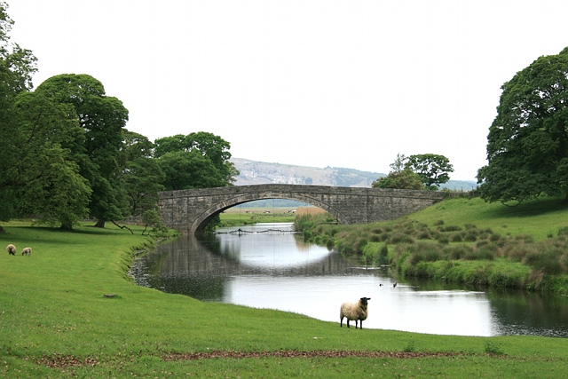
Milnthorpe Bridge
- Overview Map Street View Milnthorpe Bridge is a stone bridge, which carries the B5282 road over the River Bela, which is located about ½ mile west of Milnthorpe. The single …
Co-Curate Page
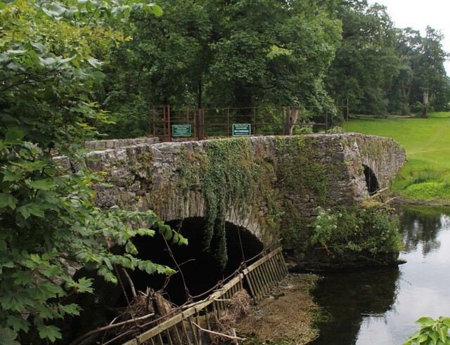
Old Bridge over River Bela, Milnthorpe
- Overview Map Street View The Old Bridge over the River Bela in Milnthorpe is a former road bridge, now a foot bridge. The stone bridge, with two segmental arches, was …
Co-Curate Page
Old Parish Boundary Post, Ackenthwaite
- Overview Map Street View There is an old boundary post at the junction of the B6384 with Paradise Lane, between Ackenthwaite and Whasset. It marked the boundary between the parishes …

Co-Curate Page
Boundary Post, B6385, by Main Line Industrial Estate
- Overview Map Street View There is an old stone boundary post, located a short distance north of the Main Line Industrial Estate. It is inscribed "M H", marking the boundary …

Co-Curate Page
Market Cross, Milnthorpe
- Overview Map Street View The Market Cross in Milnthorpe dates from the 18th century, with the cross repaired or replaced in the early 19th century. In 1845 the cross was …
Co-Curate Page
St Anthony's Tower, near Milnthorpe
- Overview Map Street View St Anthony's Tower is a folly / summerhouse, located at the north of Milnthorpe. It is said to have been built to commemorate the Reform Bill …
Co-Curate Page
Church of St Thomas, Milnthorpe
- Overview About St Thomas' Church Map Street View St Thomas' Church in Milnthorpe, Cumbria, was built in 1835–1837, designed by George Webster. St Thomas' Church is in the village of …
Co-Curate Page
War Memorial, Milnthorpe
- Overview Map Street View The war memorial in Milnthorpe is located on the south side of Main Street, opposite the junction with Police Square, near St Thomas' Church. It was …
Co-Curate Page
The Cross Keys Hotel, Milnthorpe
- Overview Map Street View The Cross Keys was a hotel and bar on Park Road in Milnthorpe. It closed in October 2022. The building dates from the early 19th century, …
Co-Curate Page
Milnthorpe Bridge
- Overview Map Street View Milnthorpe Bridge is a stone bridge, which carries the B5282 road over the River Bela, which is located about ½ mile west of Milnthorpe. The single …
Co-Curate Page
Old Bridge over River Bela, Milnthorpe
- Overview Map Street View The Old Bridge over the River Bela in Milnthorpe is a former road bridge, now a foot bridge. The stone bridge, with two segmental arches, was …
Co-Curate Page
Old Parish Boundary Post, Ackenthwaite
- Overview Map Street View There is an old boundary post at the junction of the B6384 with Paradise Lane, between Ackenthwaite and Whasset. It marked the boundary between the parishes …
")

