Topics > Civil Parishes in Cumbria > Grange-Over-Sands Civil Parish > Historic Buildings and Monuments in Grange-over-Sands
Historic Buildings and Monuments in Grange-over-Sands
Listed buildings and scheduled monuments in Grange-over-Sands Civil Parish, Cumbria, from the National Heritage List for England[1]. In the absence of a published 'local list', some other public buildings of interest may also be included. Use the Search (below) if looking for a specific building / monument.
| Structure | List No. | Grade | Built~ | Note |
|---|---|---|---|---|
| Nos. 1-8, Yewbarrow Terrace | 1269665 | II | C19th | Shops with flats above |
| Abbot Hall | 1269671 | II | 1840s | Kents Bank, Kirkhead Road |
| Abbot Hall Lodge | 1269672 | II | C19th | |
| Animal Shelter to North of Boathouse at Castle Head | 1269678 | II | C19th | |
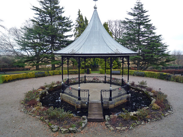
| Bandstand in Park Road Gardens | 1269655 | II | c.1904 | Restored c.1990 |
| Former Barclays Bank | 1269685 | II | c.1905 | Main Street. Now a house. |
| Bay Hall | 1269686 | II | 1849 | Main Street. |
| Blawith Lodge | 1269660 | II | 1890 | Windermere Road |
| Brown Robin (Three Adjoining Cottages of the Same Name) | 1269675 | II | C17th | Lindale Road |
| Castle Head | 1269676 | II | C18th | Large house, near Linsdale |
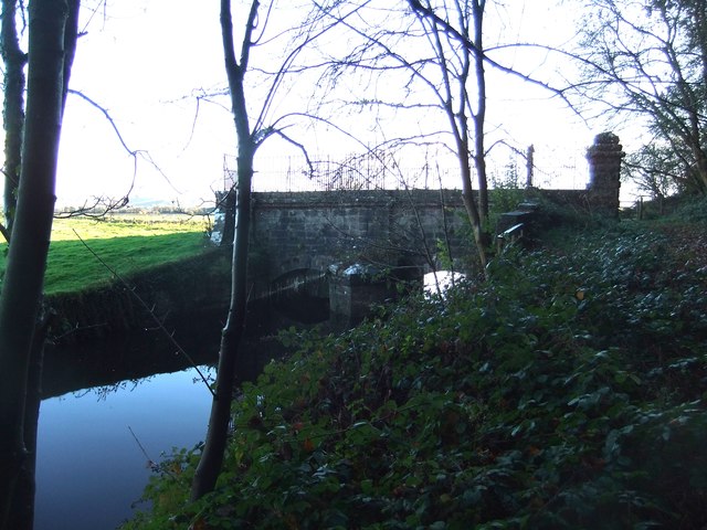
| Castle Head Bridge | 1269679 | II | c.1800 | |
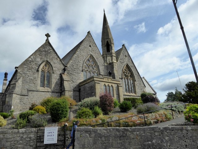
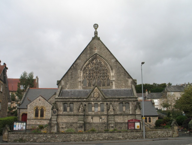
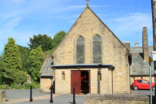
| Church of St Paul | 1269708 | II | 1854 | |
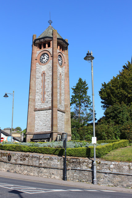
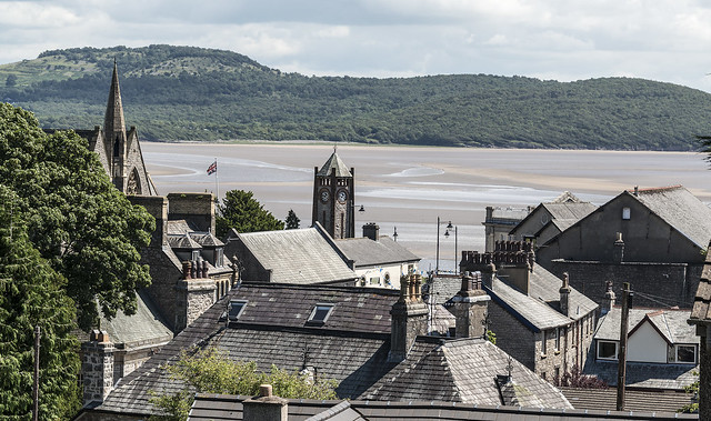
| Clock Tower | 1269687 | II | 1912 | |
| Coffee Pot Cafe | 1269688 | II | C19th | Main Street. Former house. |
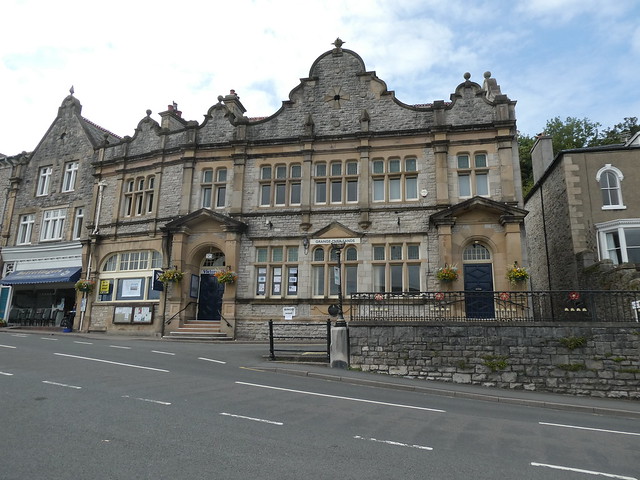
| Council Offices | 1269689 | II | 1901 | Victoria Hall, Main street. |
| Farm Buildings Adjoining to South of Middle Fell Gate Farmhouse | 1269707 | II | C18th | Cartmel Road |
| Farm Buildings to South East of High Farmhouse | 1269710 | II | C18th | Hampsfell Road |
| Fellgate | 1269705 | II | C17th | Cartmel Road |
| Fern Cottage | 1269650 | II | C19th | Main Street |
| Field Gate Between Merlewood Gardens and Farm | 1269662 | II | C19th | Gate and gate piers |
| Former Stable Block at Castle Head | 1269677 | II | 1864 | |
| Former Stable Block to Grange Hotel | 1269658 | II | 1866 | Station Square |
| Garden Temple at Holme Island House to South of House Including Attached Bridge | 1269653 | II | C19th | |
| Gate Piers to South of South Lodge to Castle Head | 1269681 | II | C19th | |
| Grange Hotel | 1269657 | II | 1866 | Station Square. |
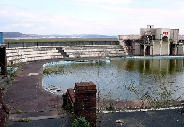
| Grange Over Sands Lido | 1402086 | II | 1932 | Off the Pomonade |
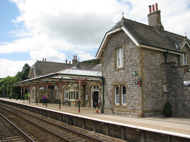
| Grange over Sands Railway Station | 1269659 | II | c.1877 | Replacing earlier station |
| Guides Farmhouse and Attached Farm Buildings | 1269699 | II | C17th | Cart Lane |
| Hardcragg Hall | 1269709 | II | C17th | Grange Fell Road |
| Hawthorne Cottage | 1269700 | II | C19th | Cart Lane |
| Holme Island Lodge | 1269654 | II | C19th | |
| Kents Bank House | 1269673 | II | C19th | Kirkhead Road, Kents Bank |
| Kiln at SD40827826 to the East of Hillside Cottage and to the South of Sandyfield | 1269669 | II | C19th | Hampsfell Road |
| Merlewood | 1269661 | II | 1853 | Windermere Road. House. |
| Merlewood Lodge | 1269663 | II | 1853 | Windermere Road. |
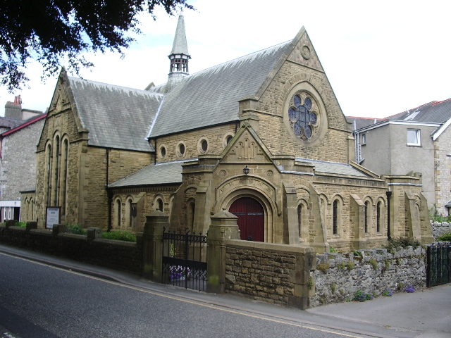
| Methodist Church | 1269670 | II | 1874 | Kents Bank Road |
| Mews Cottage | 1269674 | II | C19th | Kirkhead Road, Kents Bank |
| Middle Fell Gate Farmhouse | 1269706 | II | C18th | Cartmel Road |
| Monks Rest | 1269701 | II | C17th | Cart Lane. House. |
| Morningside Cottage Including Street Nameplate | 1269702 | II | C19th | Cart Lane |
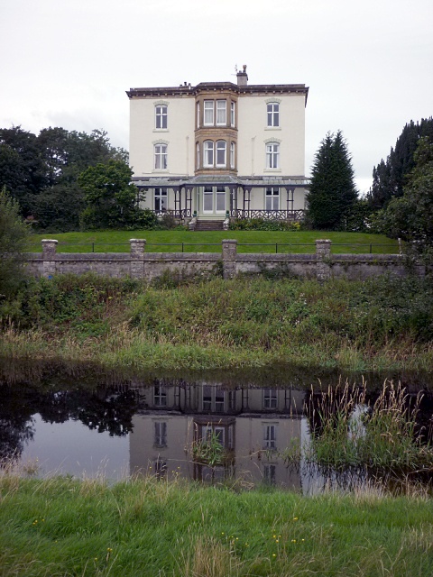
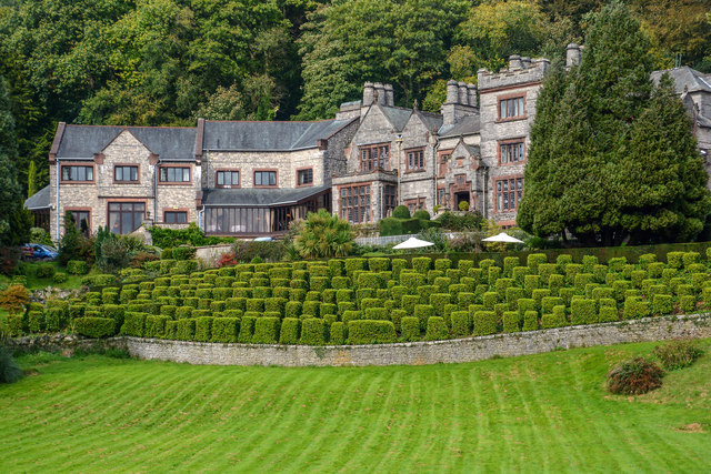
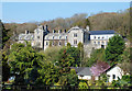
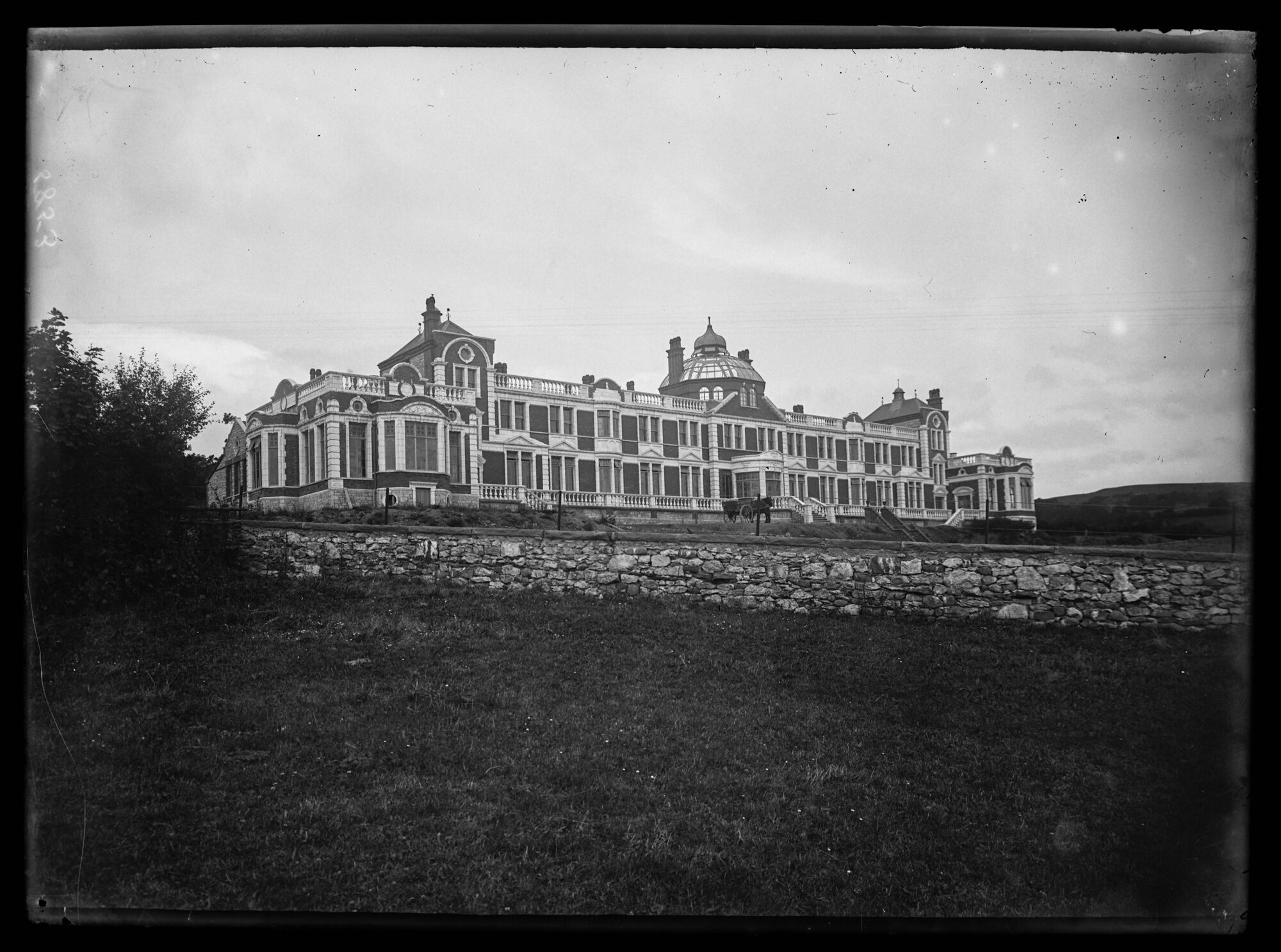
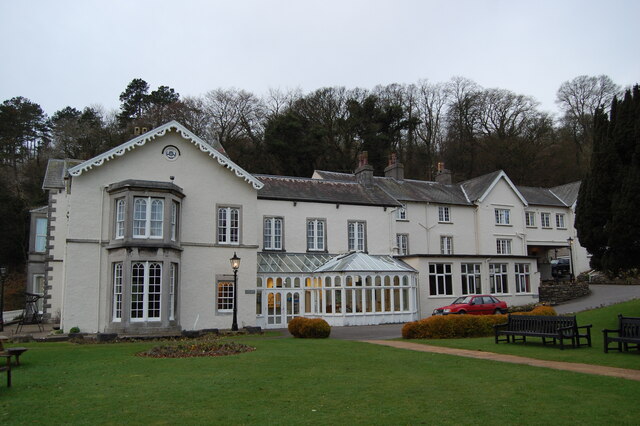
| Netherwood Hotel | 1269682 | II* | 1893 | Lindale Road. |
| Outbarn to the South East of Spring Bank Farmhouse | 1269656 | II | C19th | Spring Bank Road |
| Rose Cottage | 1269651 | II | C19th | Main Street |
| Row of Shop Premises to Right of the Grange Institute (The Institute Not Included) | 1269652 | II | C19th | Main Street |
| Slack House | 1269664 | II | C19th | Windermere Road |
| South Lodge to Castle Head | 1269680 | II | C19th | |
| The Cottage | 1269703 | II | C19th | Cart Lane |
| Two Entrance Piers to Netherwood Hotel | 1269684 | II | c.1893 | Lindale Road |
| Two Follies in Wooded Cliff Above and Belonging to Netherwood Hotel | 1269683 | II | C19th | Lindale Road |
| World War I Memorial at Cartmel Grange | 1393102 | II | c.1919 | Allithwaite Road |
| Yew Tree Farmhouse | 1269704 | II | 1740 | Cart Lane |
| Castlehead Bridge, Grange | 1007108 | n/a | c.1800 | Scheduled Monument |
| Cartmel Grange | not listed | n/a | 1914 | Allithwaite Road |
| War Memorial in Ornamental Gardens near Station Square | not listed | n/a | 1921 | Ornamental Gardens |
| Hazelwood Court | not listed | n/a | 1897 | Lindale Road. |
| United Reformed Church | not listed | n/a | 1894 | Kents Bank Road |
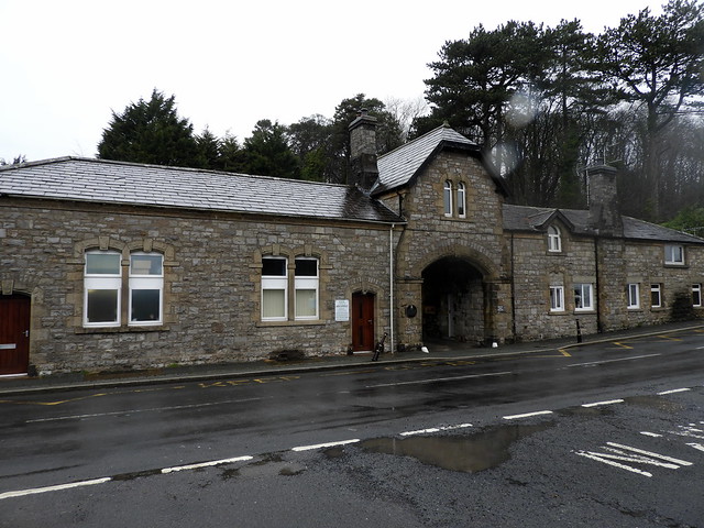
| Kents Bank Railway Station | not listed | n/a | 1865 | |
| Hampsfell Hospice | not listed | n/a | 1842 | |
| RC Church of St Charles | not listed | n/a | 1884 | Kents Bank Road |
| Grange over Sands Conservation Area | - | n/a | Conservation Area |
Primary source: the National Heritage List for England - NHLE is the register of nationally protected historic buildings and sites in England, including listed buildings, scheduled monuments, protected wrecks, registered parks and gardens, and battlefields. The list is maintained by Historic England. Check NHLE for updates and new entries. Secondary sources: British Listed Buildings.
Co-Curate Page
Church of St Paul, Grange-over-Sands
- Overview About St Paul's Church Map Street View St Paul's Church is in Crown Hill, Grange-over-Sands, Cumbria, England. It is an active Anglican parish church in the deanery of …
Co-Curate Page
Grange Lido
- Overview About Grange Lido Map The lido in Grange-over-Sands, accessed off the Promenade, was constructed in 1932 and designed by Mr Bernard Smith, Grange over Sands Urban District Council Surveyor. …
Co-Curate Page
Clock Tower, Grange-over-Sands
- Overview Map Street View The Clock Tower is a prominent landmark in Grange-over-Sands, located on the junction of Main Street and Church Hill. The tower is constructed of locally quarried limestone …
Co-Curate Page
Victoria Hall, Grange-over-Sands
- Overview Map Street View The Victoria Hall is located on Main street in Grange-over-Sands. It was built by public subscription to celebrate Queen Victoria’s Diamond Jubilee, the Hall was officially …
Co-Curate Page
Netherwood Hotel, Grange-over-Sands
- Overview Map Street View The Netherwood Hotel is located on the hillside, by Lindale Road in Grange-over-Sands. Formerly it was a country house known as Blawith, buit in 1893, by …
Co-Curate Page
Bandstand, Park Road Gardens
- Overview Map Street View Inside The ornamental cast iron bandstand is a central feature of Park Road Gardens in Grange-over-Sands. It was built by Harold Porritt, a textile factory director from …
Co-Curate Page
Castle Head Bridge, Grange-over-Sands
- Overview Map Bridge over the River Winster, with sluice gates. c1800. Limestone ashlar and rubble, with iron railings on north parapet. Has 2 segmental arches , with cutwaters projecting to north …
Co-Curate Page
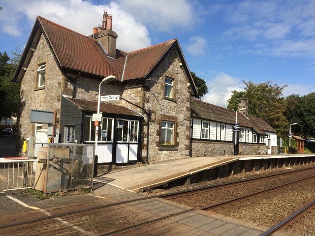
Grange-Over-Sands Railway Station
- Overview Map Street View Inside The railway station was originally opened as 'Grange' on the 27th of August 1857 by the Ulverstone and Lancaster Railway (it became known as Grange-over-Sands' …
Co-Curate Page
Grange Hotel, Grange-over-Sands
- Overview Map The Grange Hotel is located off Station Square in Grange-over-Sands. It was originally built as a railway hotel and stands to the north of the Railway Station. The …
Co-Curate Page
Former Stable Block of the Grange Hotel, Grange-over-Sands
- Overview Map Street View The former stable block to The Grange Hotel is located on Station Square in Grange-over-Sands. It was built in 1866 for the Furness Railway Company, probably …
Co-Curate Page
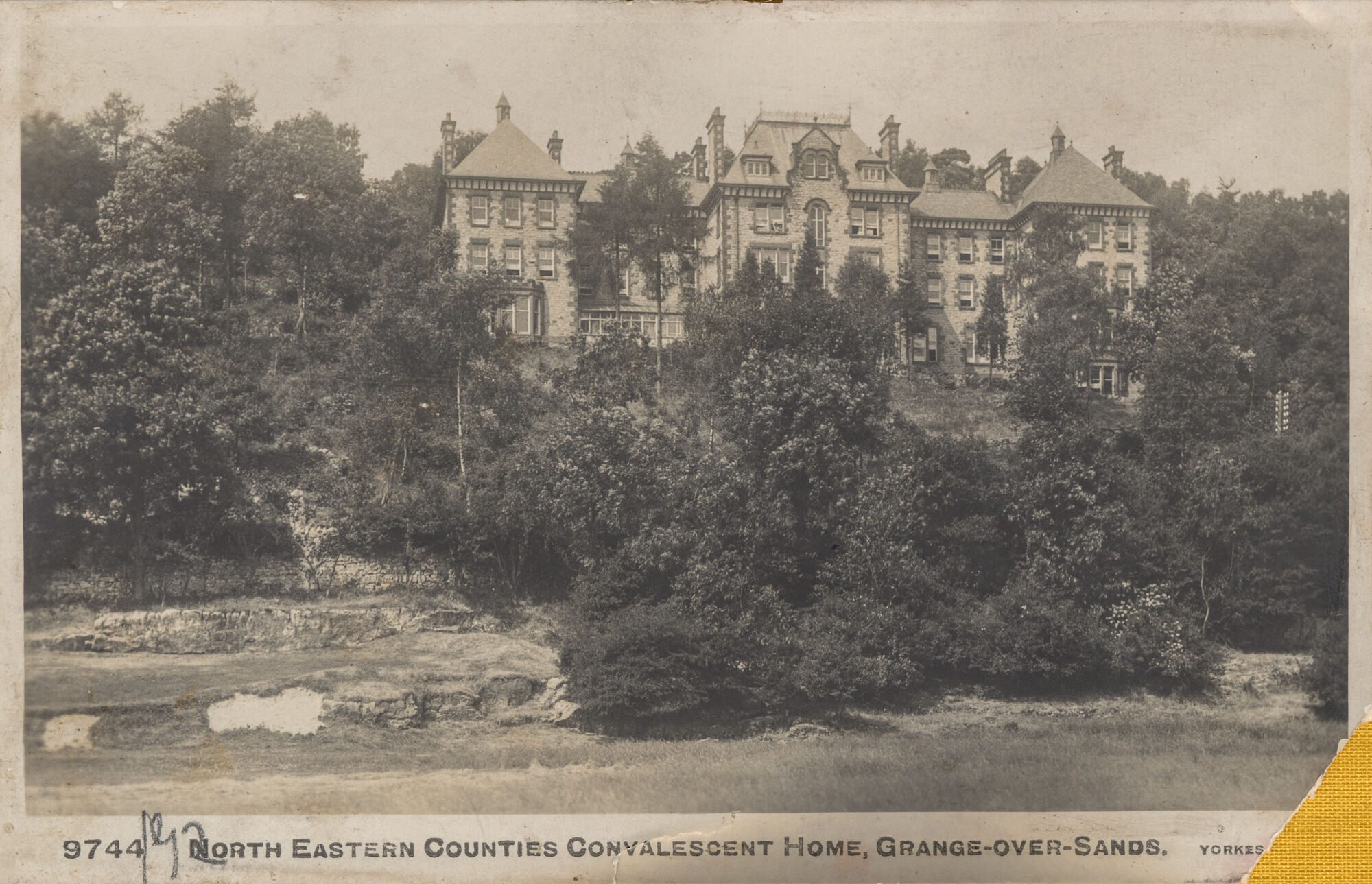
Cartmel Grange Care Home
- Overview Map Street View Cartmel Grange is located on Allithwaite Road in Grange-over-Sands. It was originally built in 1914 as a convalescent home for the Working Men's Club and Institute …
Co-Curate Page
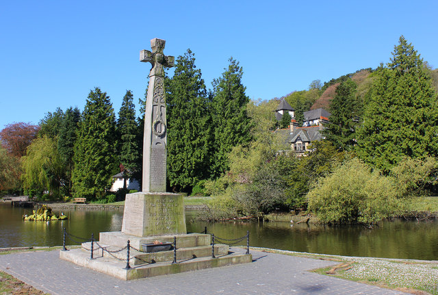
War Memorial, Grange-over-Sands
- Overview Map Street View The War Memorial in Grange-over-Sands is located in the Ornamental Gardens by Station Road. It is in the style of a 7th century Anglian cross with …
Co-Curate Page
Hazelwood Court, Grange-over-Sands
- Overview Map Street View Hazelwood Court is located on the hillside, off Lindale Road, about ½ mile north-east of Grange-over-Sands. This is the originally the North Eastern Counties Friendly Societies …
Co-Curate Page
Grange Methodist Church
- Overview Map Street View Grange Methodist Church is located on Kents Bank Road in Grange-over-Sands. It was originally built as a Wesleyan Methodist chapel, in a Gothic-style, by Ernest Bates. …
Co-Curate Page
United Reformed Church, Grange-Over-Sands
- Overview Map Street View This United Reformed Church is located on Kents Bank Road in Grange-over-Sands. It was originally a Congregational Church built in 1894, replacing an earlier wooden chapel …
Co-Curate Page
Kents Bank Railway Station
- Overview Map Street View The station building at Kents Bank was designed in 1865 by the Lancaster-based architects, Paley and Austin, for the Furness Railway. The station is now unstaffed …
Co-Curate Page
Abbot Hall, Kents Bank
- Overview Map Abbot Hall is located on Kirkhead Road in Kents Bank, Grange-over-Sands. Originally built as a house in the 1840s, by Webster of Kendal, it was extended in c.1870. …
Co-Curate Page
St Charles Borromeo RC Church, Grange-over-Sands
- Overview Map Street View St Charles Borromeo Roman Catholic Church is located on Kents Bank Road in Grange-over-Sands. The church was designed in the Early English style, by E. Simpson …

Co-Curate Page
Church of St Paul, Grange-over-Sands
- Overview About St Paul's Church Map Street View St Paul's Church is in Crown Hill, Grange-over-Sands, Cumbria, England. It is an active Anglican parish church in the deanery of …
Co-Curate Page
Grange Lido
- Overview About Grange Lido Map The lido in Grange-over-Sands, accessed off the Promenade, was constructed in 1932 and designed by Mr Bernard Smith, Grange over Sands Urban District Council Surveyor. …
Co-Curate Page
Clock Tower, Grange-over-Sands
- Overview Map Street View The Clock Tower is a prominent landmark in Grange-over-Sands, located on the junction of Main Street and Church Hill. The tower is constructed of locally quarried limestone …
Co-Curate Page
Victoria Hall, Grange-over-Sands
- Overview Map Street View The Victoria Hall is located on Main street in Grange-over-Sands. It was built by public subscription to celebrate Queen Victoria’s Diamond Jubilee, the Hall was officially …
Co-Curate Page
Netherwood Hotel, Grange-over-Sands
- Overview Map Street View The Netherwood Hotel is located on the hillside, by Lindale Road in Grange-over-Sands. Formerly it was a country house known as Blawith, buit in 1893, by …
Co-Curate Page
Bandstand, Park Road Gardens
- Overview Map Street View Inside The ornamental cast iron bandstand is a central feature of Park Road Gardens in Grange-over-Sands. It was built by Harold Porritt, a textile factory director from …
Co-Curate Page
Castle Head Bridge, Grange-over-Sands
- Overview Map Bridge over the River Winster, with sluice gates. c1800. Limestone ashlar and rubble, with iron railings on north parapet. Has 2 segmental arches , with cutwaters projecting to north …
Co-Curate Page
Grange-Over-Sands Railway Station
- Overview Map Street View Inside The railway station was originally opened as 'Grange' on the 27th of August 1857 by the Ulverstone and Lancaster Railway (it became known as Grange-over-Sands' …
Co-Curate Page
Grange Hotel, Grange-over-Sands
- Overview Map The Grange Hotel is located off Station Square in Grange-over-Sands. It was originally built as a railway hotel and stands to the north of the Railway Station. The …
Co-Curate Page
Former Stable Block of the Grange Hotel, Grange-over-Sands
- Overview Map Street View The former stable block to The Grange Hotel is located on Station Square in Grange-over-Sands. It was built in 1866 for the Furness Railway Company, probably …
Co-Curate Page
Cartmel Grange Care Home
- Overview Map Street View Cartmel Grange is located on Allithwaite Road in Grange-over-Sands. It was originally built in 1914 as a convalescent home for the Working Men's Club and Institute …
Co-Curate Page
War Memorial, Grange-over-Sands
- Overview Map Street View The War Memorial in Grange-over-Sands is located in the Ornamental Gardens by Station Road. It is in the style of a 7th century Anglian cross with …
Co-Curate Page
Hazelwood Court, Grange-over-Sands
- Overview Map Street View Hazelwood Court is located on the hillside, off Lindale Road, about ½ mile north-east of Grange-over-Sands. This is the originally the North Eastern Counties Friendly Societies …
Co-Curate Page
Grange Methodist Church
- Overview Map Street View Grange Methodist Church is located on Kents Bank Road in Grange-over-Sands. It was originally built as a Wesleyan Methodist chapel, in a Gothic-style, by Ernest Bates. …
Co-Curate Page
United Reformed Church, Grange-Over-Sands
- Overview Map Street View This United Reformed Church is located on Kents Bank Road in Grange-over-Sands. It was originally a Congregational Church built in 1894, replacing an earlier wooden chapel …
Co-Curate Page
Kents Bank Railway Station
- Overview Map Street View The station building at Kents Bank was designed in 1865 by the Lancaster-based architects, Paley and Austin, for the Furness Railway. The station is now unstaffed …
Co-Curate Page
Abbot Hall, Kents Bank
- Overview Map Abbot Hall is located on Kirkhead Road in Kents Bank, Grange-over-Sands. Originally built as a house in the 1840s, by Webster of Kendal, it was extended in c.1870. …
Co-Curate Page
St Charles Borromeo RC Church, Grange-over-Sands
- Overview Map Street View St Charles Borromeo Roman Catholic Church is located on Kents Bank Road in Grange-over-Sands. The church was designed in the Early English style, by E. Simpson …


Church of St Paul, Grange-over-Sands

Grange over Sands Conservation Area
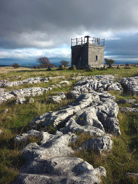
Hampsfell Hospice, Grange-over-Sands
Bandstand, Park Road Gardens, Grange-over-Sands
Grange-Over-Sands Railway Station
War Memorial, Grange-over-Sands
Grange Hotel, Grange-over-Sands
Former Stable Block of the Grange Hotel, Grange-over-Sands
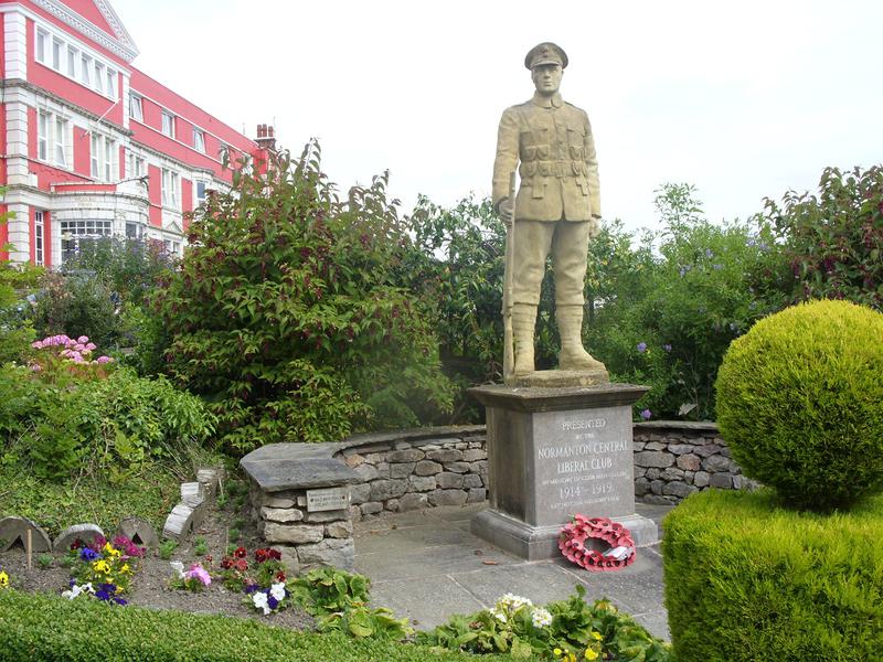
War Memorial at Cartmel Grange
Hazelwood Court, Grange-over-Sands
United Reformed Church, Grange-Over-Sands
Clock Tower, Grange-over-Sands
Victoria Hall, Grange-over-Sands
Netherwood Hotel, Grange-over-Sands


