Topics > County Durham > Burnopfield > Historic Buildings and Monuments in Burnopfield and Dipton Area
Historic Buildings and Monuments in Burnopfield and Dipton Area
Listed buildings and scheduled monuments in Burnopfield and Dipton Electoral Ward (unparished area), County Durham, from the National Heritage List for England[1]. Use the Search (below) if looking for a specific building / monument.
| Structure | List No. | Grade | Built~ | Notes |
|---|---|---|---|---|
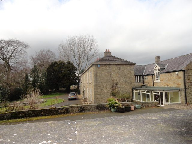
| Lintz Green House | 1240737 | II | C18th | Lintz Green |
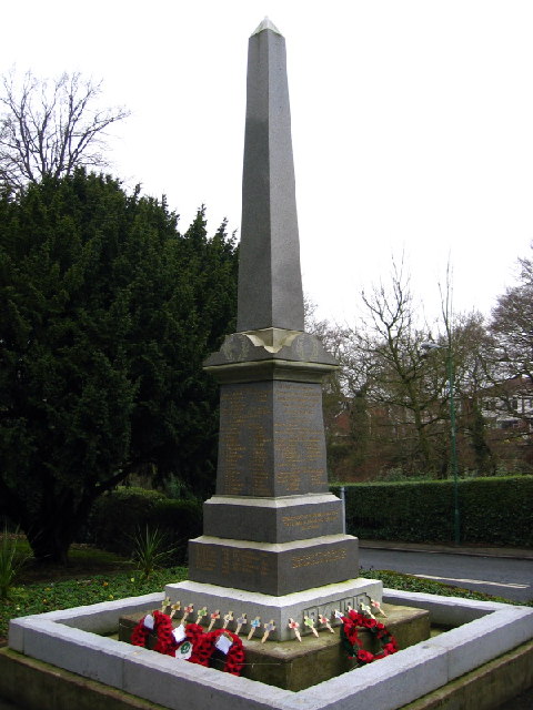
| Burnopfield War Memorial | 1433856 | II | 1921 | Buropfield |
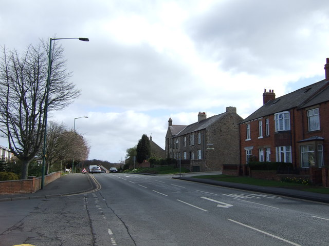
| Nos. 30 and 32, Front Street | 1260824 | II | c.1840 | Buropfield |
| Bridge East of A694 Leading to Lintzford House (T and W Bridge No 766) | 1025173 | II | C18th | Lintzford |
| Burnopfield House | 1240869 | II* | C18th | Buropfield |
| Caretaker's House of Former Leazes Board School | 1240955 | II | 1893 | Buropfield |
| Church of St John | 1240728 | II | 1886 | Dipton |
| Farm Outbuildings East of Leap Mill Farmhouse | 1240814 | II | C18th | Buropfield |
| Former Leazes Board School | 1240954 | II | 1893 | Buropfield. Now Buropfield Community Hall |
| Former Paper Mill | 1260859 | II | c.1840 | Lintzford |
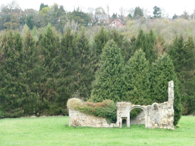
| Friarside Chapel | 1240894 | II* | C14th | Ruins. Scheduled Ancient Monument |
| Gate Piers and Walls in Front of Pontop Hall | 1240731 | II | C18th | |
| Leap Mill Farmhouse and Aqueduct Wall, with Pigsty/Henhouse Attached | 1240813 | II* | C18th | |
| Leazes Hall | 1240738 | II | C18th | Buropfield |
| Lintzford House | 1240733 | II | C18th | Lintzford |
| Mill Race Reservoir Retaining Wall and Sluice South of Leap Mill Farmhouse | 1240815 | II | C18th | Buropfield |
| Mill Race Walls and Sluice with Piers and Sluice Keepers Shelter Adjacent | 1260860 | II | c.1840 | Lintzford |
| Pontop Hall | 1240730 | II* | C17th | nr. Dipton |
| St Patrick's Congregation War Memorial, Dipton | 1430731 | II | 1921 | Dipton |
| Walls and Piers in Front of Number 30 and 32 | 1240818 | II | c.1840 | Buropfield |
| Walls in Front of Former Leazes Board School and Caretaker's House | 1240956 | II | 1893 | Buropfield |
| Walls, Piers and Railings at Entrance to Lintz Green House | 1260854 | II | C19th | Lintz Green |
Primary source: the National Heritage List for England - NHLE is the register of nationally protected historic buildings and sites in England, including listed buildings, scheduled monuments, protected wrecks, registered parks and gardens, and battlefields. The list is maintained by Historic England. Check NHLE for updates and new entries. Secondary sources: British Listed Buildings and Keys to the Past.
Co-Curate Page
Lintz Green House
- Lintz Green House, by the B6310 road at Lintz Green dates from the mid 18th century, with 1828 extensions (dated on rain water heads). The rear stairs are said to …
Co-Curate Page
War Memorial, Burnopfield
- Overview Map Street View The War Memorial is located at the junction of Front Street and New Road in Burnopfield. The memorial was made by W Ayton and Sons of …
Co-Curate Page
Friarside Chapel, nr Burnopfield
- Overview Map High Friarside Hospice was a Medieval leper hospital, located just south of the River Derwent, north of Burnopfield and south of Rowlands Gill, in County Durham. The hospital was founded …
Co-Curate Page
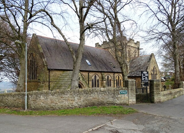
Church of St John, Dipton
- Overview Map Street View St Joh's is a former church on Front Street in Dipton. St John the Evangelist Church was built 1885-1886 to the designs of Oliver and Leeson. …
Co-Curate Page
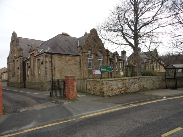
Burnopfield Community Centre
- Overview Map Street View Burnopfield Community Centre is located on Syke Road in Buropfield. The Jacobean style building dates from 1893 and was originally built as Leazes Board School. The school opened …
Co-Curate Page
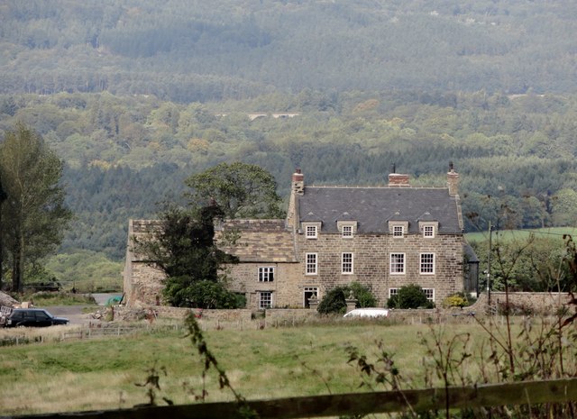
Pontop Hall
- Overview Map Street View Pontop Hall, located a short distance north of Dipton, is a farmhouse which dates from the late 17th century, with later alterantions. The building is Grade II* …

Co-Curate Page
Lintz Green House
- Lintz Green House, by the B6310 road at Lintz Green dates from the mid 18th century, with 1828 extensions (dated on rain water heads). The rear stairs are said to …
Co-Curate Page
War Memorial, Burnopfield
- Overview Map Street View The War Memorial is located at the junction of Front Street and New Road in Burnopfield. The memorial was made by W Ayton and Sons of …
Co-Curate Page
Friarside Chapel, nr Burnopfield
- Overview Map High Friarside Hospice was a Medieval leper hospital, located just south of the River Derwent, north of Burnopfield and south of Rowlands Gill, in County Durham. The hospital was founded …
Co-Curate Page
Church of St John, Dipton
- Overview Map Street View St Joh's is a former church on Front Street in Dipton. St John the Evangelist Church was built 1885-1886 to the designs of Oliver and Leeson. …
Co-Curate Page
Burnopfield Community Centre
- Overview Map Street View Burnopfield Community Centre is located on Syke Road in Buropfield. The Jacobean style building dates from 1893 and was originally built as Leazes Board School. The school opened …