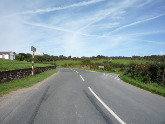
Topics > Civil Parishes in Cumbria > Skelton Civil Parish > Farms in Cumberland
Farms in Cumberland
A few of the many farms (extant and historic) in Cumberland. Work in progress.
| Name | Locality | Civil Parish | Notes |
|---|---|---|---|
| Aikshaw | Holme St Cuthbert | ||
| Birdoswald | Waterhead | Listed, former farmhouse | |
| Bleatarn Park | Irthington | Listed | |
| Bridge End Farm | Boot | Eskdale | |
| Broomhill | Irthington | ||
| Broomwell | Irthington | ||
| Brotherilkeld | Eskdale | Listed | |
| Brunstock Farm and Dairy | Brunstock | Stanwix Rural | Listed |
| Burns Farm | near Hollin Root | St. John's Castlerigg and Wythburn | |
| Cambeckhill | Cambeckhill | Irthington | Listed |
| Cotehill | Cotehill | Brampton | Listed |
| Cumrew | Cumrew | Cumrew | Listed |
| Demesne Farm | Bewcastle | Bewcastle | Listed |
| Dovecote | Dovecote | Burtholme | |
| East Oldwall | Irthington | Listed | |
| Eden Croft | Stanwix Rural | Listed | |
| Eden Steads | Low Crosby | Stanwix Rural | Listed |
| Fawcettlees Farm | NY5651373584 | ||
| Fiddleback | West Woodside | Westward | Listed |
| Forge House | Holmrook | Eskdale | Listed |
| Gallowberry | Irthington | ||
| Gillalees | Askerton | ||
| Goodyhills | Holme St Cuthbert | ||
| Green Farm | Wetheral | Wetheral | Listed |
| Greensburn | Brampton (tbc) | NY5715069957 | |
| Hall Farm | Moorhouse | Burgh by Sands | Listed |
| Heads Wood | NY5033963209 | ||
| High Crosby | High Crosby | Stanwix Rural | Listed |
| Hollins | Hollins | Wasdale | |
| Jericho | Holme St Cuthbert | ||
| John Peel Farm | Greenrigg | Caldbeck | Listed |
| Knowehill | Holme East Waver | Listed | |
| Linefoot Farm | Linefoot | Broughton Moor | |
| Long Rigg Farm | Eskdale Green | Eskdale | Listed |
| Lordstown | Bewcastle | Listed | |
| Low Grains | Bewcastle | Listed | |
| Lowsay Farm | Holme St Cuthbert | Listed | |
| Moor House | Rickerby | Stanwix Rural | Listed. Former farmhouse. |
| Moresby Hall Farm | Moresby Hall | Parton | Listed |
| Muncaster Head | Eskdale | ||
| New Cowper | Holme St Cuthbert | ||
| Newby Demense | Irthington | ||
| Northrigg Hill | Banks | Waterhead | Listed |
| Oak Hose | Stanwix Rural | Listed. Former farmhouse. | |
| Old Wall | Irthington | Listed | |
| Plasketlands | Holme St Cuthbert | ||
| Peel O' Hill | Bewcastle | Listed. Bastle | |
| Prior Rigg | Irthington | Listed | |
| Raughtonhead Hill | Raughton Head | Dalston | Listed |
| Rinnion Hills Farm | Brampton (tbc) | NY5712870008 | |
| Roanstrees | Bewcastle | Listed | |
| Salta | Holme St Cuthbert | ||
| Scare | Irthington | Listed | |
| Schoose Farm and Windmill | Schoose | Workington | Listed |
| Sleetbeck Farm | Bewcastle | Listed | |
| Smithsteads farm | NY56467387 | ||
| Spadeadam | Brampton (tbc) | ||
| Stonewalls | Laversdale | Irthington | Listed |
| Tarraby Farm | Tarraby | Stanwix Rural | Listed |
| The Ash | Oakshaw Ford | Bewcastle | Listed |
| The Beck | Irthington | Listed | |
| The Croft (aka Newby East) | Irthington | Listed | |
| The Flatt | Bewcastle | Listed | |
| The loan | Bewcastle | Listed | |
| The Nook | Irthington | Listed | |
| Town Foot | Bewcastle | Bewcastle | Listed |
| Town Head | Houghton | Stanwix Rural | Listed |
| Wall House | Irthington | Listed | |
| Walby | Walby | Stanwix Rural | Listed |
| Westknowe | Irthington | Listed | |
| Wetheral Abbey Farm | Wetheral | Wetheral | Model farm. Listed |
| Whillanside | Boot | Eskdale | Listed |
| Willowford Farm | Gilsland | Upper Denton | Listed. By Hardian's Wall |
| Whintingstown | Bewcastle | Listed | |
| Wintershields Farm | NY5568072289 | ||
| Wormanby | Burgh by Sands | Listed |
Co-Curate Page
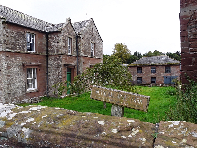
Wetheral Abbey Farm
- This is a Model farm, built in 1857 by James Stewart of Carlisle, incorporating parts of a medieval priory and a post-medieval farmstead. It is Grade II listed on the …
Co-Curate Page
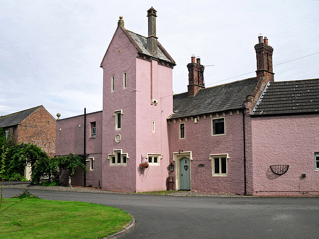
Old Dairy, Brunstock.
- Overview Map Street View The farmhouse and former Dairy to Brunstock House is located on Brunstock Lane in Brunstock. The building dates from the late 1820's with additions dated 1845, …


Co-Curate Page
Green Farm, Wetheral
- The farmhouse of the former Green Farm is located on The Green in Wetheral. The house dates from the late 18th century. It is a Grade II listed building on …

Co-Curate Page
Cambeckhill
- Overview Map Street View Cambeckhill Farm is located about 2 miles north-west of Brampton, in Cumbria. It is situated to the west of Cam Beck (river) and is on the …

Co-Curate Page
Hollins, Wasdale
- Overview Map Hollins is a farm, located about 1 mile south-west of Nether Wasdale and 2 miles east of Gosforth, in Cumbria. The farm is situated to the east of …
Co-Curate Page
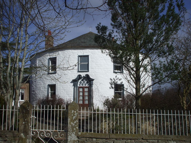
Fiddleback Farmhouse
- Overview Map Street View Fiddleback is a farm and B&B in West Wodside in Cumbria. The farmhouse was built in 1709 and has a distinctive curved walls and shaped like …

Co-Curate Page
Northrigg Hill
- Overview Map Northrigg Hill, is located about ½ mile north-east of the village of Banks in Cumbria. The farmhouse at Northrigg Hill is dated 1836 over it's entrance. The building …

Co-Curate Page
Dovecote, Burtholme
- Overview Map Street View Dovecote is a farm in Cumbria, located about ½mile east of the village of Walton and 1½ miles north of Brampton. It is part of Burtholme …

Co-Curate Page
Wormanby Farm
- Overview Map Street View Wormanby Farm is located about ½mile south-east of Burgh by Sands. The farmhouse at Wormandy is dated 1772, with a further date of 1850 and inscription …

Co-Curate Page
Hall Farm, Moorhouse
- Overview Map Street View Hall Farm is located in Moorhouse. The farmhouse dates from the late 17th century, with 19th century alterations. It is a Grade II listed building on …
Co-Curate Page
Jericho
- Overview Map Street View Jericho is located about 7½ miles north-east of Maryport in Cumberland. It consists of a single residence. Jericho is part of Holme St Cuthbert Civil Parish …

Co-Curate Page
New Cowper
- Overview Map Street View New Cowper is a hamlet and farm in Cumbria, located about 18 miles south-west of Carlisle and 1 mile north-west of the village of Westnewton. Sandylands …
Co-Curate Page
Goodyhills
- Overview Map Street View Goodyhills is a hamlet and farm in Cumbria, located just over a mile east of Mawbray. It is part of Holme St Cuthbert Civil Parish and …
Co-Curate Page
Plasketlands
- Overview Map Street View Plasketlands (aka Plasket Lands) is a dairy farm in Cumbria, located about 1½ miles east of the village of Mawbray. It is situated by Jordan Burn. …

Co-Curate Page
Salta
- Overview Map Street View Salta is a hamlet and farm close to the Solway Firth in Cumbria, loacted about 1 mile SSE of the village of Mawbray, and 6 miles …
Co-Curate Page
Aikshaw
- Overview Map Street View Aikshaw is a hamlet in the Allerdale district of Cumbria, located about 8 miles west of Wigton and 3 miles north of Aspatria. The settlement includes …
Co-Curate Page
Lowsay Farm
- Overview Map Street View Lowsay is a farm in Cumbria, located about 2½ miles south of Siloth and 2 miles north-east of the village of Mawbray. The farmhouse dates from …
Co-Curate Page
Knowehill
- Overview Map Street View Knowehill is a farm in Cumbria, situated by the River Waver, and located about 4½ miles north-west of Wigton and 2½ miles south-west of Newton Arlosh. …
Co-Curate Page
Muncaster Head
- Overview Map Muncaster Head is located in Eskdale (valley) about ¾mile south-east of the village of Eskdale, and 3 miles north-east of Muncaster. An iron bloomery forge was recorded at …

Co-Curate Page
Wetheral Abbey Farm
- This is a Model farm, built in 1857 by James Stewart of Carlisle, incorporating parts of a medieval priory and a post-medieval farmstead. It is Grade II listed on the …
Co-Curate Page
Old Dairy, Brunstock.
- Overview Map Street View The farmhouse and former Dairy to Brunstock House is located on Brunstock Lane in Brunstock. The building dates from the late 1820's with additions dated 1845, …
Co-Curate Page
Green Farm, Wetheral
- The farmhouse of the former Green Farm is located on The Green in Wetheral. The house dates from the late 18th century. It is a Grade II listed building on …
Co-Curate Page
Cambeckhill
- Overview Map Street View Cambeckhill Farm is located about 2 miles north-west of Brampton, in Cumbria. It is situated to the west of Cam Beck (river) and is on the …
Co-Curate Page
Hollins, Wasdale
- Overview Map Hollins is a farm, located about 1 mile south-west of Nether Wasdale and 2 miles east of Gosforth, in Cumbria. The farm is situated to the east of …
Co-Curate Page
Fiddleback Farmhouse
- Overview Map Street View Fiddleback is a farm and B&B in West Wodside in Cumbria. The farmhouse was built in 1709 and has a distinctive curved walls and shaped like …
Co-Curate Page
Northrigg Hill
- Overview Map Northrigg Hill, is located about ½ mile north-east of the village of Banks in Cumbria. The farmhouse at Northrigg Hill is dated 1836 over it's entrance. The building …
Co-Curate Page
Dovecote, Burtholme
- Overview Map Street View Dovecote is a farm in Cumbria, located about ½mile east of the village of Walton and 1½ miles north of Brampton. It is part of Burtholme …
Co-Curate Page
Wormanby Farm
- Overview Map Street View Wormanby Farm is located about ½mile south-east of Burgh by Sands. The farmhouse at Wormandy is dated 1772, with a further date of 1850 and inscription …
Co-Curate Page
Hall Farm, Moorhouse
- Overview Map Street View Hall Farm is located in Moorhouse. The farmhouse dates from the late 17th century, with 19th century alterations. It is a Grade II listed building on …
Co-Curate Page
Jericho
- Overview Map Street View Jericho is located about 7½ miles north-east of Maryport in Cumberland. It consists of a single residence. Jericho is part of Holme St Cuthbert Civil Parish …
Co-Curate Page
New Cowper
- Overview Map Street View New Cowper is a hamlet and farm in Cumbria, located about 18 miles south-west of Carlisle and 1 mile north-west of the village of Westnewton. Sandylands …
Co-Curate Page
Goodyhills
- Overview Map Street View Goodyhills is a hamlet and farm in Cumbria, located just over a mile east of Mawbray. It is part of Holme St Cuthbert Civil Parish and …
Co-Curate Page
Plasketlands
- Overview Map Street View Plasketlands (aka Plasket Lands) is a dairy farm in Cumbria, located about 1½ miles east of the village of Mawbray. It is situated by Jordan Burn. …
Co-Curate Page
Salta
- Overview Map Street View Salta is a hamlet and farm close to the Solway Firth in Cumbria, loacted about 1 mile SSE of the village of Mawbray, and 6 miles …
Co-Curate Page
Aikshaw
- Overview Map Street View Aikshaw is a hamlet in the Allerdale district of Cumbria, located about 8 miles west of Wigton and 3 miles north of Aspatria. The settlement includes …
Co-Curate Page
Lowsay Farm
- Overview Map Street View Lowsay is a farm in Cumbria, located about 2½ miles south of Siloth and 2 miles north-east of the village of Mawbray. The farmhouse dates from …
Co-Curate Page
Knowehill
- Overview Map Street View Knowehill is a farm in Cumbria, situated by the River Waver, and located about 4½ miles north-west of Wigton and 2½ miles south-west of Newton Arlosh. …

