Topics > Northumberland > Northumberland Parishes and Townships - 1855 > Castle Ward, 1855
Castle Ward, 1855
Extract from: History, Topography, and Directory of Northumberland...Whellan, William, & Co, 1855.
CASTLE WARD.
This Ward, occupying the south-eastern corner of the county, is bounded on the north by Morpeth Ward, on the west by Tindale Ward, on the south by the river Tyne, which separates it from Durham, and on the east by the German Ocean. Its length, from east to west, is about fifteen miles, its breadth, from north to south, about fourteen, miles, and it comprises an area of 100,895 statute acres. The population in 1801, was 36,645; in 1841, 68,692; and in 1851, it had increased to 76,413 souls. Castle ward is highly cultivated, productive, and populous, and is well watered by the rivers Tyne, Blyth, and Pont, with their numerous tributary streams. The romantic banks of the Blyth command general admiration, and few places afford more agreeable scenery than the picturesque vale of Tyne. Numerous and extensive manufactories, collieries, ship-yards, coal-staiths, etc., are situated here, and afford employment to great numbers of the inhabitants. This ward is divided into two divisions, East and West, and comprehends fourteen parishes, two parochial chapelries, and one extra-parochial place, of which the following is an enumeration, showing the number of acres and houses, together with the population, in 1851, of each place : -
| Parish etc. | Acres | Houses | Males | Females | Total |
|---|---|---|---|---|---|
| All Saints | 2,201 | 5,142 | 16,522 | 17,070 | 33,592 |
| Cramlington | 3,492 | 651 | 1,810 | 1,557 | 3,367 |
| Dinnington | 5,538 | 155 | 335 | 333 | 668 |
| Earsdon | 11,646 | 2,152 | 6,694 | 5,288 | 10,982 |
| Gosforth | 6,355 | 622 | 1,138 | 1,181 | 2,319 |
| Horton | 5,550 | 692 | 2,313 | 2,136 | 4,449 |
| Long Benton | 9,040 | 1,809 | 4,816 | 4,380 | 9,205 |
| Meldon | 993 | 29 | 71 | 73 | 144 |
| Newburn | 11,566 | 890 | 2,220 | 2,096 | 4,316 |
| Ponteland | 10,073 | 23 | 547 | 590 | 1,137 |
| River Green | 480 | 7 | 20 | 14 | 34 |
| St. Andrew's | 6,035 | 3,145 | 9,848 | 11,351 | 21,199 |
| St. John's | 2,358 | 3,650 | 15,166 | 15,980 | 31,146 |
| Stannington | 10,093 | 209 | 488 | 512 | 1,000 |
| Tynemouth | 7,222 | 4,814 | 14,453 | 16,071 | 30,524 |
| Wallsend | 2,787 | 878 | 2,883 | 2,838 | 5,721 |
| Whalton | 5,918 | 114 | 244 | 217 | 461 |
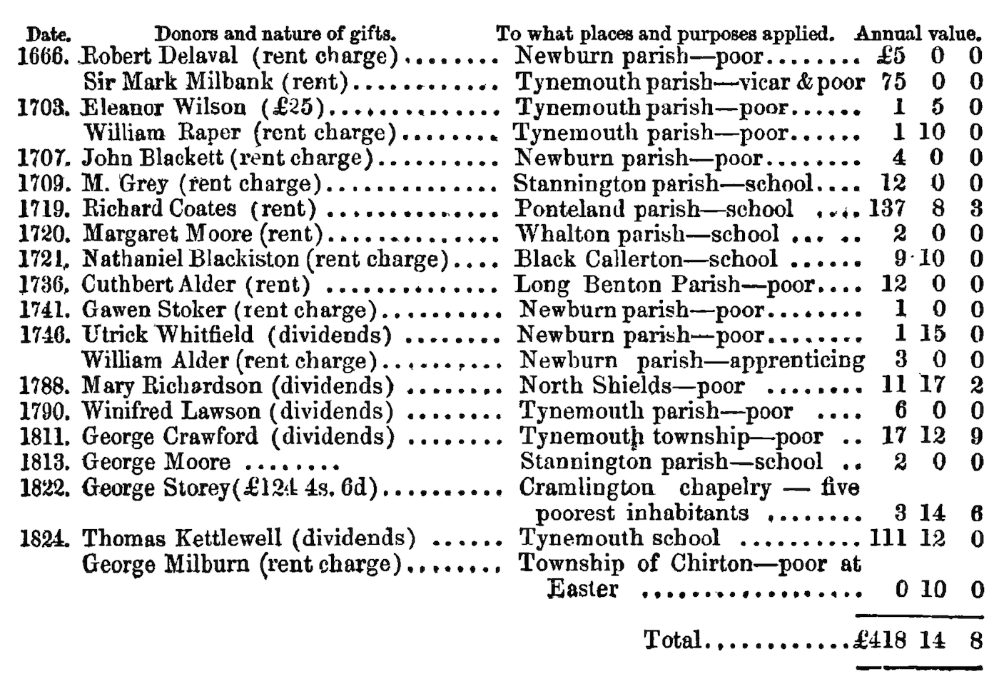
THE CHARITIES OF CASTLE WARD.
With the date of nearly each bequest, the name of the donor, the amount, appropriation, and annual value, as abstracted from the Reports of the Commissioners for inquiring respecting Charities, printed by order of the House of Commons. See also the histories of the parishes, etc.

Co-Curate Page
All Saints' Parish, 1855
- Extract from: History, Topography, and Directory of Northumberland...Whellan, William, & Co, 1855. This parish comprises the townships of All Saints', Byker, and Heaton, the former of which constitutes the eastern …
Co-Curate Page
Cramlington, 1855
- Extract from: History, Topography, and Directory of Northumberland...Whellan, William, & Co, 1855. CRAMLINGTON PAROCHIAL CHAPELRY. This chapelry, forming a portion of the parish of St. Andrew, Newcastle, is bounded on …
Co-Curate Page
Dinnington Parish, 1855
- Extract from: History, Topography, and Directory of Northumberland...Whellan, William, & Co, 1855. DINNINGTON PARISH. DINNINGTON is a parish, comprising the townships of Brenkley, Dinnington, Horton Grange, Mason, Prestwick, and …
Co-Curate Page
Earsdon Parish, 1855
- Extract from: History, Topography, and Directory of Northumberland...Whellan, William, & Co, 1855. EARSDON PARISH EARSDON, a. parish comprising the townships of Backworth, Blyth and Newsham, Burradon, Earsdon, Hartley, Holywell, Seaton …
Co-Curate Page
Gosforth Parish, 1855
- Extract from: History, Topography, and Directory of Northumberland...Whellan, William, & Co, 1855. GOSFORTH PARISH. GOSFORTH parish comprises the townships of East Brunton, West Brunton, Coxlodge, Fawdon, North Gosforth, South …
Co-Curate Page
Horton Parochial Chapelry, 1855
- Extract from: History, Topography, and Directory of Northumberland...Whellan, William, & Co, 1855. HORTON PAROCHIAL CHAPELRY. HORTON is a parochial chapelry comprising the townships oi Bebside, Cowpen, Hartford East, Hartford …
Co-Curate Page
Longbenton Parish, 1855
- Extract from: History, Topography, and Directory of Northumberland...Whellan, William, & Co, 1855. LONG BENTON PARISH LONG BENTON parish comprises the townships of Killingworth, Long Benton, Walker, and Weetslade, whose …
Co-Curate Page
Meldon Parish, 1855
- Extract from: History, Topography, and Directory of Northumberland...Whellan, William, & Co, 1855. MELDON PARISH. MELDON parish is situated in the north-west corner of Castle Ward, and comprises an area …
Co-Curate Page
Newburn Parish, 1855
- Extract from: History, Topography, and Directory of Northumberland...Whellan, William, & Co, 1855. NEWBURN PARISH NEWBURN, a parish in the west division of Castle Ward, and east division of Tindale …
Co-Curate Page
Ponteland Parish, 1855
- Extract from: History, Topography, and Directory of Northumberland...Whellan, William, & Co, 1855. PONTELAND PARISH PONTELAND is a parish comprising the townships of Berwick Hill, Callerton (High), Callerton (Little), Coldcoats, …
Co-Curate Page
River Green, extra parochial liberty, 1855
- Extract from: History, Topography, and Directory of Northumberland...Whellan, William, & Co, 1855. RIVER GREEN is a small extra parochial liberty, situated on the south bank of the river Wansbeck, five …
Co-Curate Page
St Andrew's Parish, Newcastle - 1855
- Extract from: History, Topography, and Directory of Northumberland...Whellan, William, & Co, 1855. ST. ANDREW'S parish comprises the townships of Fenham, Jesmond, and St. Andrew, and the parochial chapelry of Cramlington. …
Co-Curate Page
St John's Parish, Newcastle - 1855
- Extract from: History, Topography, and Directory of Northumberland...Whellan, William, & Co, 1855. ST. JOHN'S PARISH. This parish comprises the townships of Benwell, Elswick, St. John, and Westgate, the two …
Co-Curate Page
Stannington Parish, 1855
- Extract from: History, Topography, and Directory of Northumberland...Whellan, William, & Co, 1855. STANNINGTON PARISH. Stannington parish is divided into three divisions, called respectively Stannington North-East Quarter, Stannington North-West Quarter, …
Co-Curate Page
Tynemouth Parish, 1855
- Extract from: History, Topography, and Directory of Northumberland...Whellan, William, & Co, 1855. TYNEMOUTH parish is bounded on the north and west by the parishes or Earsdon, Long Benton, and Wallsend, …
Co-Curate Page
Wallsend Parish, 1855
- Extract from: History, Topography, and Directory of Northumberland...Whellan, William, & Co, 1855. WALLSEND parish comprises the townships of Howden Pans, Wallsend and Willington, whose united area amounts to 2,787 acres. …
Co-Curate Page
Whalton Parish, 1855
- Extract from: History, Topography, and Directory of Northumberland...Whellan, William, & Co, 1855. WHALTON PARISH. WHALTON is a parish comprising the townships of Newham, Ogle, Riplington and Whalton. It is …

Co-Curate Page
All Saints' Parish, 1855
- Extract from: History, Topography, and Directory of Northumberland...Whellan, William, & Co, 1855. This parish comprises the townships of All Saints', Byker, and Heaton, the former of which constitutes the eastern …
Co-Curate Page
Cramlington, 1855
- Extract from: History, Topography, and Directory of Northumberland...Whellan, William, & Co, 1855. CRAMLINGTON PAROCHIAL CHAPELRY. This chapelry, forming a portion of the parish of St. Andrew, Newcastle, is bounded on …
Co-Curate Page
Dinnington Parish, 1855
- Extract from: History, Topography, and Directory of Northumberland...Whellan, William, & Co, 1855. DINNINGTON PARISH. DINNINGTON is a parish, comprising the townships of Brenkley, Dinnington, Horton Grange, Mason, Prestwick, and …
Co-Curate Page
Earsdon Parish, 1855
- Extract from: History, Topography, and Directory of Northumberland...Whellan, William, & Co, 1855. EARSDON PARISH EARSDON, a. parish comprising the townships of Backworth, Blyth and Newsham, Burradon, Earsdon, Hartley, Holywell, Seaton …
Co-Curate Page
Gosforth Parish, 1855
- Extract from: History, Topography, and Directory of Northumberland...Whellan, William, & Co, 1855. GOSFORTH PARISH. GOSFORTH parish comprises the townships of East Brunton, West Brunton, Coxlodge, Fawdon, North Gosforth, South …
Co-Curate Page
Horton Parochial Chapelry, 1855
- Extract from: History, Topography, and Directory of Northumberland...Whellan, William, & Co, 1855. HORTON PAROCHIAL CHAPELRY. HORTON is a parochial chapelry comprising the townships oi Bebside, Cowpen, Hartford East, Hartford …
Co-Curate Page
Longbenton Parish, 1855
- Extract from: History, Topography, and Directory of Northumberland...Whellan, William, & Co, 1855. LONG BENTON PARISH LONG BENTON parish comprises the townships of Killingworth, Long Benton, Walker, and Weetslade, whose …
Co-Curate Page
Meldon Parish, 1855
- Extract from: History, Topography, and Directory of Northumberland...Whellan, William, & Co, 1855. MELDON PARISH. MELDON parish is situated in the north-west corner of Castle Ward, and comprises an area …
Co-Curate Page
Newburn Parish, 1855
- Extract from: History, Topography, and Directory of Northumberland...Whellan, William, & Co, 1855. NEWBURN PARISH NEWBURN, a parish in the west division of Castle Ward, and east division of Tindale …
Co-Curate Page
Ponteland Parish, 1855
- Extract from: History, Topography, and Directory of Northumberland...Whellan, William, & Co, 1855. PONTELAND PARISH PONTELAND is a parish comprising the townships of Berwick Hill, Callerton (High), Callerton (Little), Coldcoats, …
Co-Curate Page
River Green, extra parochial liberty, 1855
- Extract from: History, Topography, and Directory of Northumberland...Whellan, William, & Co, 1855. RIVER GREEN is a small extra parochial liberty, situated on the south bank of the river Wansbeck, five …
Co-Curate Page
St Andrew's Parish, Newcastle - 1855
- Extract from: History, Topography, and Directory of Northumberland...Whellan, William, & Co, 1855. ST. ANDREW'S parish comprises the townships of Fenham, Jesmond, and St. Andrew, and the parochial chapelry of Cramlington. …
Co-Curate Page
St John's Parish, Newcastle - 1855
- Extract from: History, Topography, and Directory of Northumberland...Whellan, William, & Co, 1855. ST. JOHN'S PARISH. This parish comprises the townships of Benwell, Elswick, St. John, and Westgate, the two …
Co-Curate Page
Stannington Parish, 1855
- Extract from: History, Topography, and Directory of Northumberland...Whellan, William, & Co, 1855. STANNINGTON PARISH. Stannington parish is divided into three divisions, called respectively Stannington North-East Quarter, Stannington North-West Quarter, …
Co-Curate Page
Tynemouth Parish, 1855
- Extract from: History, Topography, and Directory of Northumberland...Whellan, William, & Co, 1855. TYNEMOUTH parish is bounded on the north and west by the parishes or Earsdon, Long Benton, and Wallsend, …
Co-Curate Page
Wallsend Parish, 1855
- Extract from: History, Topography, and Directory of Northumberland...Whellan, William, & Co, 1855. WALLSEND parish comprises the townships of Howden Pans, Wallsend and Willington, whose united area amounts to 2,787 acres. …


, East Pier, Scarborough")


