Topics > Heritage Sites > Hadrian's Wall > Carvoran Roman fort
Carvoran Roman fort
Map showing Carvoran Roman fort (shaded area) within the wider Scheduled Monument area.
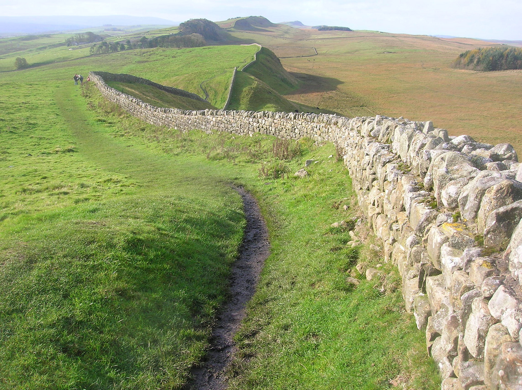
The remains of Carvoran fort, known to the Romans as Magna, are located on Hadrian's Wall (Wall Mile 46), about ½mile north-east of Greenhead in Northumberland. The remains are part of a Scheduled Monument (legally protected), which also includes a section of the vallum of Hadrian's Wall.
Scheduled Monument (#1010991): Carvoran Roman fort and Hadrian's Wall and vallum between the unclassified road to Old Shield and the field boundary west of the fort in wall miles 45 and 46
Click the headings below to expand (selected extracts from the Historic England scheduling)
Carvoran Roman fort, known to the Romans as Magna, is situated near the crest of the steep west facing slope overlooking the gap in the Tipalt valley. It guards both this important gap and river crossing and also the junction of the Stanegate and Maiden Way. The fort probably originates from the same period as the Stanegate, around AD 80, and was later included in the Hadrianic frontier, started in AD 122. It is not actually attached to Hadrian's Wall, but lies about 220m to the south of the Wall and 160m south of the vallum.
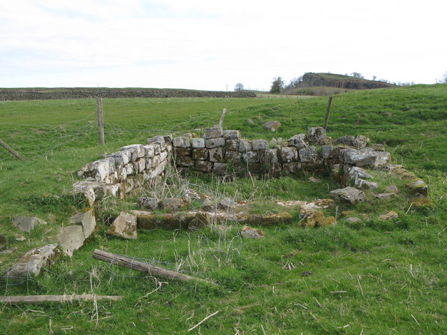
The stone fort is visible as a turf covered platform with some exposed masonry at the north west angle tower. This fort measures 135m by 111m over the ramparts, enclosing an area just under 1.5ha. Antiquaries who visited the site from 1599 onwards all record the presence of substantial buildings and streets within the stone wall of the fort. A bath house with plastered walls was observed within the south wall near the south west angle.
Aerial photography has revealed the south west corner of a larger predecessor to the visible stone fort between the south west corner of the stone fort and the B6318 road. A faint crop mark running north-south observed south east of Carvoran House may also be associated with this large fort. The Roman name, Magna, is not appropriate for the relatively small stone fort and suggests that it replaced an earlier larger fort. Further Roman ditches were located in 1985 east of Carvoran House which may belong to a third fort.
The pre-Hadrianic history of Carvoran is clearly complex, with the possibility that, like Vindolanda, it consisted initially of a smallish fort which was replaced by one or more larger forts before the construction of the visible small stone fort. As there has been no organised excavation at this site most of what is known comes from chance finds across the site and aerial photography. A number of altars and inscriptions testify to the various detachments which were stationed at the fort at one time or other. These included Hamian archers from Syria and the first cohort of Batavians. Probably the most interesting find to date is the inscription on a stone tablet of a metrical hymn dedicated to the Virgin of the Zodiac, now in the Museum of Antiquities at Newcastle. A well within the fort yielded a set of stag's antlers and an iron javelin head, both in very good condition.
The civil settlement outside the fort, usually referred to as a `vicus', was very extensive according to the accounts of the antiquaries who visited the remains. Horsley, writing in 1732, states clearly that the remains of the vicus were located to the south and west of the fort. No visible remains of the vicus to be seen above ground today, but its remains survive as buried features. The vicus is also testified to, by the numerous dedications to the god Vitiris. A bronze measuring container, or `modius', weighing 26 pounds was discovered in 1915 just north of the north east corner of the fort. It is inscribed and names the emperor Domitian under whom it was made. Domitian died in 96 AD, implying that the Roman occupation at Carvoran probably predated the Wall.
from https://www.geograph.org.uk/p…
Carvoran (Magna) Roman Fort - tower at northwest corner (2)
- Photo by Mike Quinn, 22 April, 2009, Geograph, CC-Y-SA 2.0
Added by
Simon Cotterill

from https://historicengland.org.u…
Carvoran Roman fort and Hadrian's Wall and vallum between the unclassified road to Old Shield and the field boundary west of the fort in wall miles 45 and 46 - List Entry
- .....The monument includes the Roman fort at Carvoran and Hadrian's Wall and vallum and their associated features between the road to Old Shield in the east and the field boundary …
Added by
Simon Cotterill
from https://www.geograph.org.uk/p…
Carvoran (Magna) Roman Fort - west boundary (2)
- Photo by Mike Quinn, 22 April, 2009, Geograph, CC-BY-SA 2.0
Added by
Simon Cotterill
from https://www.geograph.org.uk/p…
Carvoran (Magna) Roman Fort
- The name means stone or rock. Carvoran lies at the junction of the Stanegate and the Maiden Way. The fort measures 129 m by 123 m and covers about 1.65 …
Added by
Simon Cotterill

from https://www.geograph.org.uk/p…
Carvoran (Magna) Roman Fort - tower at northwest corner (2)
- Photo by Mike Quinn, 22 April, 2009, Geograph, CC-Y-SA 2.0
Added by
Simon Cotterill
from https://historicengland.org.u…
Carvoran Roman fort and Hadrian's Wall and vallum between the unclassified road to Old Shield and the field boundary west of the fort in wall miles 45 and 46 - List Entry
- .....The monument includes the Roman fort at Carvoran and Hadrian's Wall and vallum and their associated features between the road to Old Shield in the east and the field boundary …
Added by
Simon Cotterill
from https://www.geograph.org.uk/p…
Carvoran (Magna) Roman Fort - west boundary (2)
- Photo by Mike Quinn, 22 April, 2009, Geograph, CC-BY-SA 2.0
Added by
Simon Cotterill
from https://www.geograph.org.uk/p…
Carvoran (Magna) Roman Fort
- The name means stone or rock. Carvoran lies at the junction of the Stanegate and the Maiden Way. The fort measures 129 m by 123 m and covers about 1.65 …
Added by
Simon Cotterill