Topics > Heritage Sites > Hadrian's Wall > Wall Mile 4
Wall Mile 4
Hadrian's Wall - Wall Mile 4
Hadrian's Wall stretches from the east to west coast of England and was an important frontier of the Roman Empire. Building of the wall began in AD 122 and took six years to complete it's 84 mile (80 Roman mile) length. Soldiers were garrisoned along the line of the wall in large forts, smaller milecastles, and intervening turrets. The Vallum, a large ditch with mounds on either side, ran along the south side of the wall, protecting the rear of the frontier. Hadrian's Wall was designated as a World Heritage Site in 1987.
Wall Mile 4:
- Milecastle 4 (Westgate Road) - remains exist beneath nos. 67-75 Westgate Road
- Turret 4a - never found
- Turret 4b - never found
Wall Mile 4 runs through parts of Newcastle city centre and begins to head west up Westgate Road. It is a built-up area which has been heavily modified over the centuries, so not surprisingly there are no visible remains of Hadrian’s Wall. The foundations of a suspected Milecastle and old wells were discovered in 1984, during conversion of the old buildings from 67 to 75 Westgate Road into Newcastle Arts Centre. This put into doubt the long-assumed location of Milecastle 4, and subsequently Milecastles 5 & 6, all of which had been calculated, but never actually found. No turrets have been found either. However, a section of the curtain wall was uncovered in 1952 near the Mining Institute on Westgate Road.
The ditch, measuring twelve feet deep, was first identified in 1929, west of St. Nicholas Buildings, with its edges traced at various points along Westgate Road in subsequent decades. The ditch’s southern lip suggest its northern edge lies beneath the centre of Westgate Road.[1] As it’s name implies, the West Gate to the Medieval Town Walls were located here. It is highly likely that stone from Hadrian’s Wall were reused in the town walls, when they were built in the 13th and 14th centuries. Later, Westgate Road became the starting point for the Newcastle to Carlise Turnpike road, which was initially built in the 1750s as the Military Road, following the Jacobite Rising. Other sections of the Military Road are known to have been built directly on the foundations of Hadrian’s Wall, so that might possibly have been the case here.


from https://historicengland.org.u…
Hadrian's Wall in wall mile 4, sections of wall between Crawhall Road and Jubilee Road
Added by
Simon Cotterill

from Geograph (geograph)
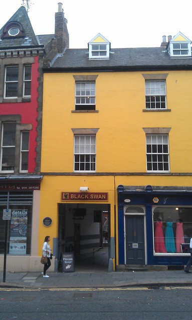
Black Swan Court, Westgate Road, Newcastle upon Tyne
Pinned by Simon Cotterill

from https://www.twsitelines.info/…
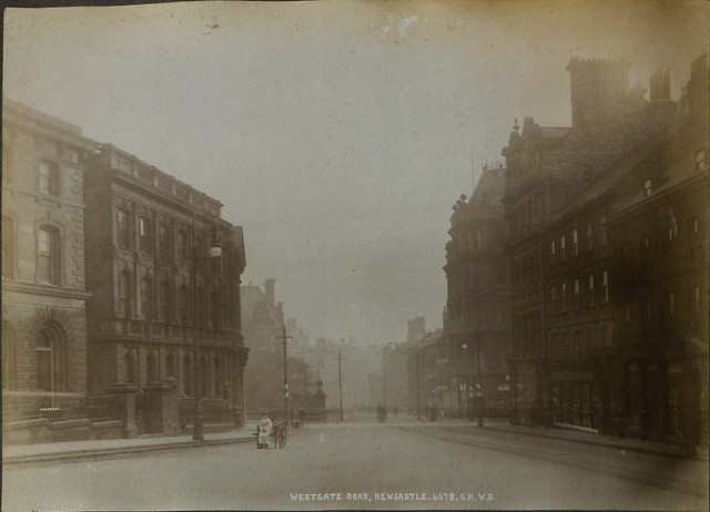
Hadrian's Wall, Dean Street to the Big Lamp (Wall mile 4)
- In this mile the Wall is supposed to have run from Milecastle 4 (not found) to Milecastle 5 (Quarry House), of which traces were reported by Horsley but which has …
Added by
Simon Cotterill
from https://www.twsitelines.info/…
Hadrian's Wall, Westgate Road, Milecastle 4
- Stone foundations, interpreted as part of a milecastle, were uncovered in 1985 in the yards behind 67-75 Westgate Road. They consisted of flagged foundations 2.90 m wide, part of the …
Added by
Simon Cotterill

from https://perlineamvalli.wordpr…
Wall Mile 4
- Wall Mile 4 (May 15, 2012). Mike Bishop's PLV blog about walking Hadrian’s Wall written from an archaeologist’s point of view. "....we reach the site of Milecastle 4 (Westgate Road), …
Added by
Simon Cotterill

from https://historicengland.org.u…
Hadrian's Wall in wall mile 4, sections of wall between Crawhall Road and Jubilee Road
Added by
Simon Cotterill
from Geograph (geograph)
Black Swan Court, Westgate Road, Newcastle upon Tyne
Pinned by Simon Cotterill
from https://www.twsitelines.info/…
Hadrian's Wall, Dean Street to the Big Lamp (Wall mile 4)
- In this mile the Wall is supposed to have run from Milecastle 4 (not found) to Milecastle 5 (Quarry House), of which traces were reported by Horsley but which has …
Added by
Simon Cotterill
from https://www.twsitelines.info/…
Hadrian's Wall, Westgate Road, Milecastle 4
- Stone foundations, interpreted as part of a milecastle, were uncovered in 1985 in the yards behind 67-75 Westgate Road. They consisted of flagged foundations 2.90 m wide, part of the …
Added by
Simon Cotterill
from https://perlineamvalli.wordpr…
Wall Mile 4
- Wall Mile 4 (May 15, 2012). Mike Bishop's PLV blog about walking Hadrian’s Wall written from an archaeologist’s point of view. "....we reach the site of Milecastle 4 (Westgate Road), …
Added by
Simon Cotterill

")

