Topics > Tyne and Wear > Newcastle upon Tyne > Jesmond > Historic Buildings and Monuments in Jesmond
Historic Buildings and Monuments in Jesmond
| Structure | List No. | Grade | Built~ | Locality | Note |
|---|---|---|---|---|---|
| No. 21, Brandling Park | 1355233 | II | C19th | Jesmond | |
| Akhurst School (Jesmond Cottage) and Gas Lamp at Door | 1024845 | II | 1831 | Jesmond | Former school, originally a house |
| All Saints' Cemetery Gate, Walls, Piers, Gates and Railings | 1299067 | II | 1856 | Jesmond | |
| All Saints' Cemetery Mortuary Chapels | 1024857 | II | 1856 | Jesmond | |
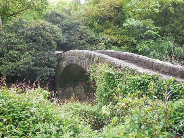
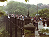
| Armstrong Bridge | 1355205 | II | 1878 | Jesmond Dene | |
| Banqueting House with added gatehouse and other extensions | 1024855 | II | 1862 | Jesmond Dene | By John Dobson. Ruins of. |
| Boundary Stone in Wall in Front of Number 7 | 1087036 | II | C19th | Jesmond | |
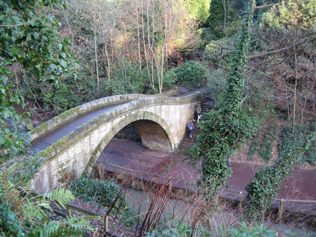
| Bridge to West of Jesmond Dene Mill | 1186739 | II | 1862 | Jesmond Dene | |
| Chapel of St Mary | 1325172 | II* | C12th | Jesmond | Ruins of. |
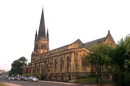
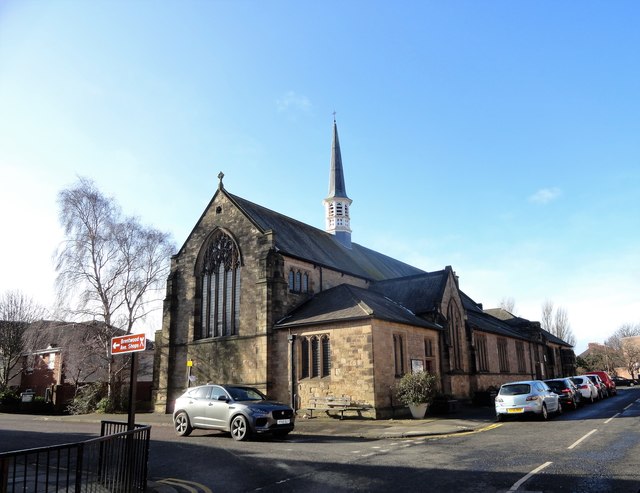
| Church of St George | 1024784 | I | 1888 | Jesmond | |
| Church of the Holy Trinity | 1024942 | II* | 1908 | Jesmond | |
| Drinking Fountain at Corner of Clayton Road | 1355246 | II | 1901 | Jesmond | |
| Entrance Archway, Pair of Chapel Lodges, Walls and Gates to Jesmond Cemetery | 1186766 | II* | 1836 | Jesmond | By John Dobson |
| Fairless Harrison Tomb About 100 Metres East of Jesmond Cemetery Gateway | 1024825 | II | 1906 | Jesmond | |
| Fleming Memorial Hospital | 1242077 | II | 1887 | Jesmond | |
| Footbridge North East of Banqueting Hall | 1024856 | II | 1870 | Jesmond Dene | |
| Gates and Gate Piers to South of Fleming Memorial Hospital | 1242086 | II | 1887 | Jesmond | |
| Hall and School of Church of St George | 1355280 | II | 1887 | Jesmond | |
| House and garden wall at 33 Brandling Park; part of garden wall to number 32 | 1355234 | II | 1820s | Jesmond | |
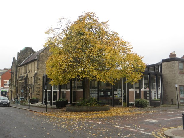
| Jesmond Branch Library | 1323708 | II | 1963 | Jesmond | |
| Jesmond Church of St Hilda | 1024758 | II | 1905 | Jesmond | Thornleigh Road |
| Jesmond Dene Mill | 1024854 | II | C19th | Jesmond Dene | |
| Jesmond Parish Church and Choir Vestry Attached | 1115542 | II | 1861 | Jesmond | By John Dobson |
| Jesmond United Reformed Church and Hall Attached | 1319998 | II | 1888 | Jesmond | |
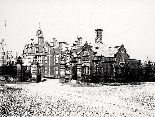
| La Sagesse School, Jesmond Towers | 1024954 | II* | C19th | Jesmond | Private mansion (former school) |
| Lodge to South of Fleming Memorial Hospital | 1260185 | II | 1887 | Jesmond | |
| Memorial to Dr William Rea | 1392258 | II | 1906 | Jesmond | in Jesmond Old Cemetery |
| No. 22 and wall attached | 1024926 | II | C19th | Jesmond | Brandling Park |
| Piers from Hospital of the Virgin Mary of Royal Grammar School | 1024894 | II | C13th | Jesmond | |
| Pillar Box North of Number 4 | 1325922 | II | 1879 | Jesmond | Osbourne Avenue |
| South Lodge, Gateway, Walls and Gates to Jesmond Cemetery | 1024860 | II* | 1836 | Jesmond | By John Dobson |
| St Mary's Well | 1355270 | II | C17th | Jesmond | Off The Grove, Jesmond |
| Sunday School Attached to Church of St Hilda | 1121525 | II | 1900 | Jesmond | |
| The Carriage Public House | 1355276 | II | c1864 | Jesmond | Former Jesmond Station |
| The Lodge | 1389144 | II | 1883 | Jesmond | |
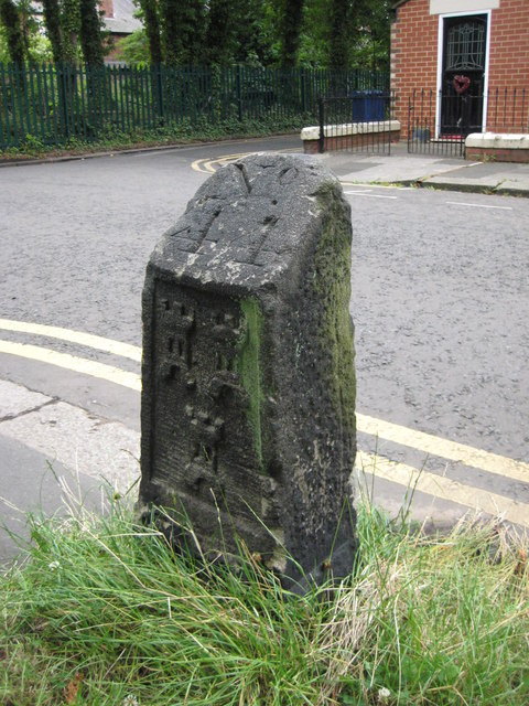
| Town Moor Boundary Stone Opposite Number 73 | 1145896 | II | C18th | Jesmond | Highbury |
| Jesmond Dene House | 1024853 | II | 1822 | Jesmond | By John Dobson |
| Patient Shelter | Not listed | n/a | 1928 | Local List, Clayton Road |
Co-Curate Page
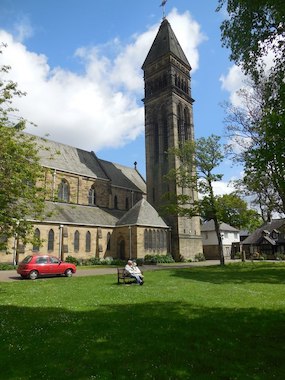
St George's Church
- History Map The Church of St George, off Osborne Road in Jesmond is a Grade I listed building. The church was designed by designed by Thomas Ralph Spence and its 154 ft …
Co-Curate Page
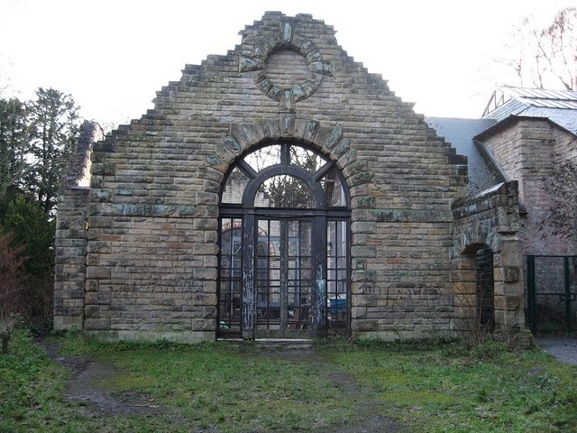
Banqueting House (ruins)
- Overview Map Street View The Banqueting Hall in Jesmond Dene, was built 1860-1862, designed by John Dobson for William Armstrong. It was extended to provide a gatehouse (off Jesmond Dene …

Co-Curate Page
St Mary's Chapel
- Overview Map Street View Pilgrim Street in Newcastle is so named because of the many pilgrims traveling that way to St Mary's Chapel in Jesmond; "THERE was an Inn in …
Co-Curate Page
Jesmond Library
- Overview Map Street View Jesmond Library was originally opened on the 30th of May 1963, the circular building on St George’s Terrace in West Jesmond was designed by Henry Faulkner …
Co-Curate Page
Armstrong Bridge
- Overview Map Armstrong Bridge is an iron bridge which spans Jesmond Dene. Originally open to traffic it is now restricted to pedestrians. The bridge hosts an arts and crafts fair …
Co-Curate Page
Church of the Holy Trinity
- Overview Map Street View The Holy Trinity Church in Jesmond is located on the corner of Jesmond Road and Churchill Gardens. The Parish church was built in 1908 by Hicks …
Co-Curate Page
Fleming Memorial Hospital (1888 - 1988)
- Overview Map Street View The Fleming (business centre) is located off Burdon Terrace in Jesmond, Newcastle. It was originally The Fleming Memorial Hospital, which was officially opened by Lord Armstrong …

Co-Curate Page
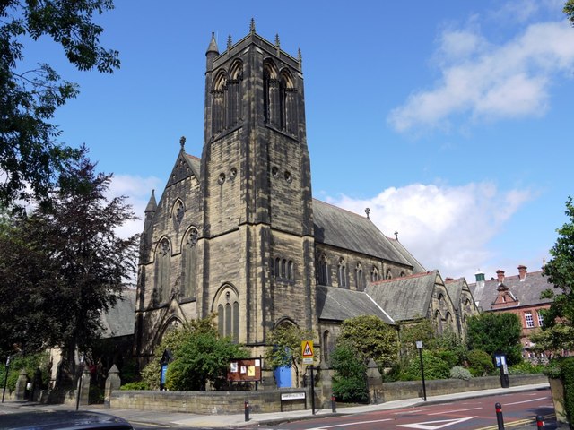
Jesmond Parish Church
- Summary Map Street View Jesmond Parish Church is located in Brandling Village in the suburb of Jesmond in Newcastle. The Gothic style church was designed by John Dobson and consecrated …
Co-Curate Page
Jesmond United Reformed Church
- Overview Map Street View A non-conformist church built 1887-1888, designed by W.L. Newcombe. The church is located on Burdon Terrace, in the Brandling Village area of Jesmond, a suburb of …
Co-Curate Page
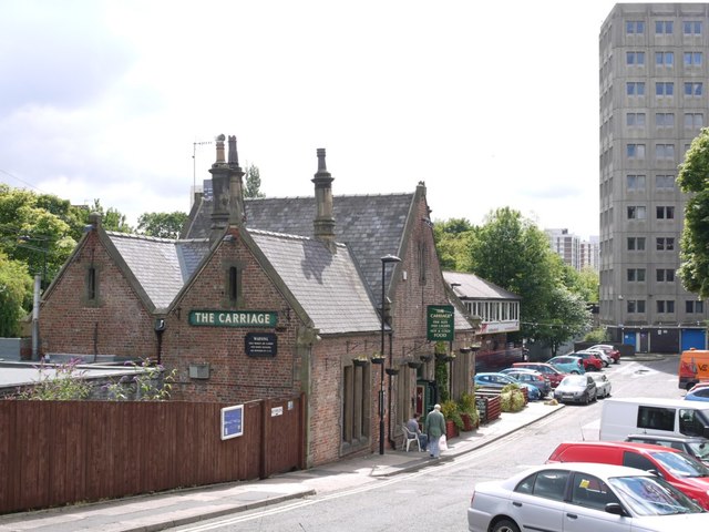
The Carriage
- Overview Map Street View The Carriage is a public house in Jesmond. It was originally Jesmond Station, which was opened in 1864 by the Blyth & Tyne Railway. It was …
Co-Curate Page
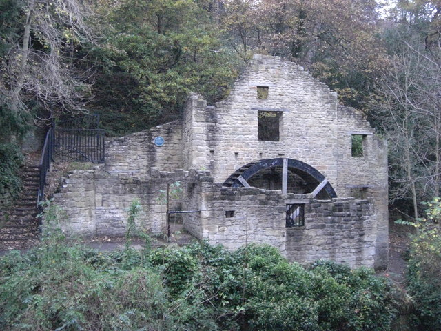
Jesmond Dene Mill
- The old water mill is located by the Ouseburn (river) in Jesmond Dene. A water mill was first recorded here in 1739, at that time known as 'Mabel's Mill'; in the …
Co-Curate Page
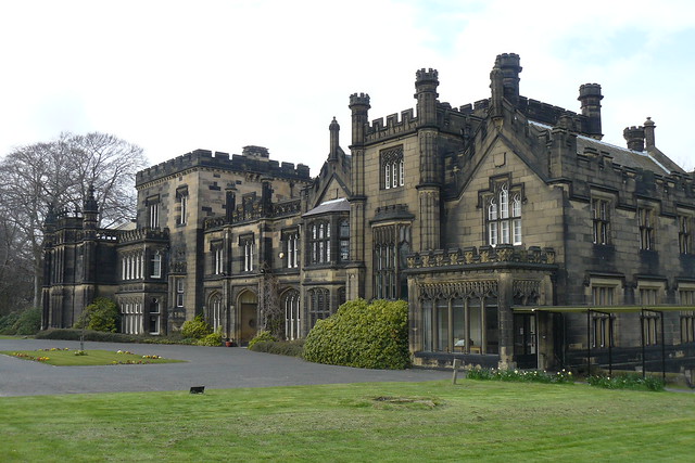
Jesmond Towers
- Overview Map Jesmond Towers is a Gothic-style mansion house located to the north of Bemersyde Drive, off Jesmond Dene Road, in Jesmond. It was built in the early 19th century …
Co-Curate Page
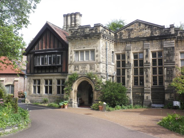
Jesmond Dene House
- Overview Map Street View Jesmond Dene House is a hotel on Jesmond Dene Road in Jesmond, Newcastle. The original Georgian house, designed by John Dobson, was built in 1822 for for …
Co-Curate Page
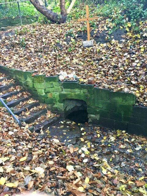
St Mary's Well, Jesmond
- Overview Map Street View St Mary's Well is located in a small fenced enclosure on the north side of The Grove in Jesmond. It as a holy well, probably dating …
Co-Curate Page
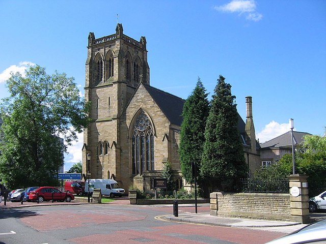
Church of St Hilda, Jesmond
- Overview Map Street View St Hilda's Church is located on Thornleigh Road, Jesmond. The Parish church, originally a daughter church of St. George, Jesmond, was built 1900-1905, by Hicks and …

Co-Curate Page
W.D. Stephens Memorial Fountain
- Overview Map Street View This memorial drinking fountain is located by the junction of the Great North Road and Clayton Road in Jesmond, Newcastle. It was erected by public subscription, …
Co-Curate Page
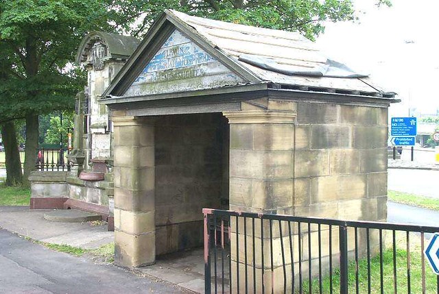
Fleming Memorial Patients' Shelter
- Overview Map Street View This Patients Shelter of the former Fleming Memorial Hospital is located by the junction of the Great North Road and Clayton Road in Jesmond, Newcastle. It …
Co-Curate Page
Town Moor boundary stone, Higbury, Jesmond
- Overview Map Street View This Town Moor boundary stone is located opposite No.73, Highbury in Jesmond, by the footpath to Jesmond Dene Road. The boundary stone dates from the 18th …

Co-Curate Page
St George's Church
- History Map The Church of St George, off Osborne Road in Jesmond is a Grade I listed building. The church was designed by designed by Thomas Ralph Spence and its 154 ft …
Co-Curate Page
Banqueting House (ruins)
- Overview Map Street View The Banqueting Hall in Jesmond Dene, was built 1860-1862, designed by John Dobson for William Armstrong. It was extended to provide a gatehouse (off Jesmond Dene …
Co-Curate Page
St Mary's Chapel
- Overview Map Street View Pilgrim Street in Newcastle is so named because of the many pilgrims traveling that way to St Mary's Chapel in Jesmond; "THERE was an Inn in …
Co-Curate Page
Jesmond Library
- Overview Map Street View Jesmond Library was originally opened on the 30th of May 1963, the circular building on St George’s Terrace in West Jesmond was designed by Henry Faulkner …
Co-Curate Page
Armstrong Bridge
- Overview Map Armstrong Bridge is an iron bridge which spans Jesmond Dene. Originally open to traffic it is now restricted to pedestrians. The bridge hosts an arts and crafts fair …
Co-Curate Page
Church of the Holy Trinity
- Overview Map Street View The Holy Trinity Church in Jesmond is located on the corner of Jesmond Road and Churchill Gardens. The Parish church was built in 1908 by Hicks …
Co-Curate Page
Fleming Memorial Hospital (1888 - 1988)
- Overview Map Street View The Fleming (business centre) is located off Burdon Terrace in Jesmond, Newcastle. It was originally The Fleming Memorial Hospital, which was officially opened by Lord Armstrong …
Co-Curate Page
Jesmond Parish Church
- Summary Map Street View Jesmond Parish Church is located in Brandling Village in the suburb of Jesmond in Newcastle. The Gothic style church was designed by John Dobson and consecrated …
Co-Curate Page
Jesmond United Reformed Church
- Overview Map Street View A non-conformist church built 1887-1888, designed by W.L. Newcombe. The church is located on Burdon Terrace, in the Brandling Village area of Jesmond, a suburb of …
Co-Curate Page
The Carriage
- Overview Map Street View The Carriage is a public house in Jesmond. It was originally Jesmond Station, which was opened in 1864 by the Blyth & Tyne Railway. It was …
Co-Curate Page
Jesmond Dene Mill
- The old water mill is located by the Ouseburn (river) in Jesmond Dene. A water mill was first recorded here in 1739, at that time known as 'Mabel's Mill'; in the …
Co-Curate Page
Jesmond Towers
- Overview Map Jesmond Towers is a Gothic-style mansion house located to the north of Bemersyde Drive, off Jesmond Dene Road, in Jesmond. It was built in the early 19th century …
Co-Curate Page
Jesmond Dene House
- Overview Map Street View Jesmond Dene House is a hotel on Jesmond Dene Road in Jesmond, Newcastle. The original Georgian house, designed by John Dobson, was built in 1822 for for …
Co-Curate Page
St Mary's Well, Jesmond
- Overview Map Street View St Mary's Well is located in a small fenced enclosure on the north side of The Grove in Jesmond. It as a holy well, probably dating …
Co-Curate Page
Church of St Hilda, Jesmond
- Overview Map Street View St Hilda's Church is located on Thornleigh Road, Jesmond. The Parish church, originally a daughter church of St. George, Jesmond, was built 1900-1905, by Hicks and …
Co-Curate Page
W.D. Stephens Memorial Fountain
- Overview Map Street View This memorial drinking fountain is located by the junction of the Great North Road and Clayton Road in Jesmond, Newcastle. It was erected by public subscription, …
Co-Curate Page
Fleming Memorial Patients' Shelter
- Overview Map Street View This Patients Shelter of the former Fleming Memorial Hospital is located by the junction of the Great North Road and Clayton Road in Jesmond, Newcastle. It …


